Good Morning!
At the end of 2021 a large earthquake swarm started to the west of the Ok shield volcano in Iceland. At the time of writing the swarm is ongoing. The Icelandic Meteorological Office (IMO) reported on their Icelandic site on 1st February 2022 that there is no evidence of magma intrusion.
The swarm is occurring west of Ok in Borgarfjörður in a low temperature region outside the main volcanic and rift area. The earthquakes are thought to be rifting caused by horizontal tension in the crust, here of the North American Plate. The swarm is the largest to date in the region and is continuing at the time of writing. So off we trotted to plot the earthquakes.
What’s in the Area?
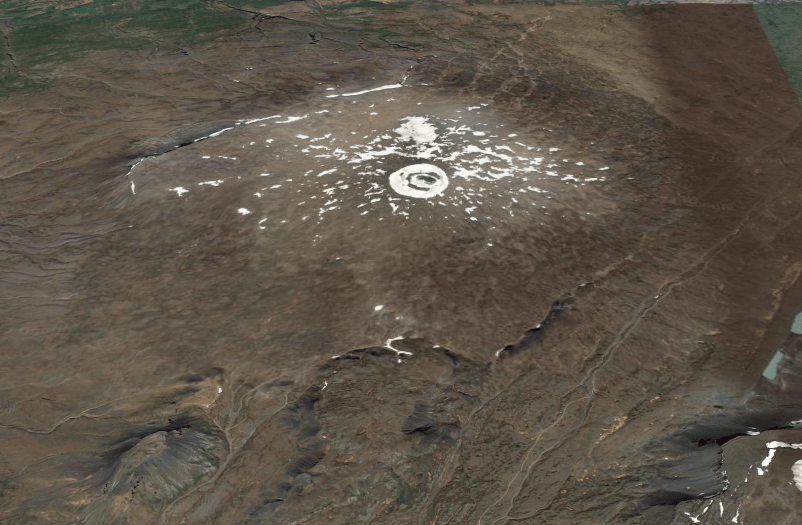
We looked at the area 64.2°N, 19.2°W to 65.3°N, 21.8°W which contains the Langjökull ice cap, two Holocene volcanic systems and several Pleistocene volcanic systems.
The Langjökull ice cap is the second largest ice cap in Iceland located at the northern end of the Western Volcanic Zone (WVZ). The WVZ is a slow spreading rift that forms the western boundary of the south Iceland microplate. Sinton et al.’s study in 2005 showed that there is no evidence for the decline in the WVZ in the Holocene; the shield eruptions are long duration with low effusion rates fed by magma from the mantle. c. 40 eruptive units have been located in the WVZ; we are focussing on those in the Langjökull area in the northern part of the zone.
Holocene Volcanoes
| Volcano | Latitude | Longitude | Last Known Eruption | Dominant Rock Type |
| Prestahnúkur | 64.583 | -20.666 | 3350 BCE | Basalt / Picro-Basalt |
| Langjökull | 64.85 | -19.7 | 950 CE | Basalt / Picro-Basalt |
Prestahnúkur is west of the Geitlandsjökull glacier in the south west part of Langjökull. It is a 90 km ling 15 km wide fissure system with a rhyolitic peak, on a Pleistocene basaltic plateau. The central volcano is a hyaloclastite massif; it has shield forming olivine tholeiite basaltic effusive eruptions, with some rhyolite. The fissures extend southwest-north east, reaching under the Þórisjökull and Geitlandsjökull glaciers. There is a parallel sub swarm of tuyas 4–6 km west of the main swarm. The last significant eruption of the central volcano was in the Pleistocene and on the fissures c.900 CE. The Holocene eruptions occurred on rift zones to the north and south west of the volcano.
Langjökull comprises the Hveravellir central volcano and a 100 km long and 20 km wide fissure system. A 600m thick ice cap partly covers the system. The central volcano is another hyaloclastic massif with a silicic component. It has had six recorded Holocene eruptions: 2 VEI 2, Hallmundahraun 950 CE and Kjalhraun 5850 BCE; and, 4 VEI 0, Lambahraun 2050 BCE, Krákshraun 2550 BCE, Strytuhraun 3550 BCE and Leggjarbrjótur 8600 BCE. The Hallmundahraun lava flow covers 240 km2 . Kjalhraun is a shield which erupted 11km3 lava 7,800 years ago. The dominant magmas are olivine tholeiite basalt.
Skjaldbreiður is a shield volcano that lies in the southern part of the Langjökull system. It erupted 13km3 of basaltic lava in the early Holocene. The lava flows formed the basin of Þingvallavatn and Þingvellir, where Iceland’s parliament, the Alþing, was founded in 930.
Pleistocene Volcanoes
| Volcano | Latitude | Longitude | Primary Volcano Type |
| Geysir | 64.32 | -20.3 | Stratovolcano |
| Hlöðufell | 64.93 | -20.53 | Tuya |
| Þórisjökull | 64.53 | -20.7 | Subglacial |
| Ok | 64.62 | -20.88 | Shield |
| Eiríksjökull | 64.77 | -20.4 | Tuya |
| Hrútfell | 64.73 | -19.72 | Tuya |
| Bláfell | 64.492 | -19.87 | Tuya |
| Hreppar | 64.42 | -19.5 | Fissure vent(s) |
The Geysir geothermal area lies in the Haukadalur basin near the southern end of the Langjökull system. Earthquake activity in June 2000 temporarily activated the normally somnolent Grand Geysir
Eiríksjökull is Iceland’s largest tuya.
Ok erupted during interglacials in the Pleistocene. It used to have a summit glacier, the Okjökull, whose disappearance has been attributed to climate change. Local volcanologists have reminded us that the ash from the 2010 Eyjafjalljökull eruption would have contributed to ice loss. “Not Ok” was a documentary about the lost glacier. Ok overlies some of the tuyas of the sub swarm to the west of Prestahnúkur.
Hreppar is two NE-SW trending ridges which extend from the rhyolitic Kerlingarfjöll volcano located SW of the Hofsjökull ice cap.
Recent Seismic Activity
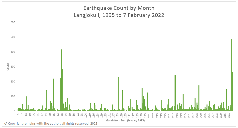
As we have extended our database of Icelandic earthquakes back to 1995, we have plotted the earthquakes for the period from 1995 to 7th February 2022 for the area 64.2°N 19.2°W to 65.3°N 21.8°W.
There is a relatively low level of background activity compared to the other volcanic regions of Iceland. However, the following months each saw more than 200 earthquakes: 55 (July 1999) near Þórisjökull and Prestahnúkur , 66 (June 2000) near Geysir, 67 (July 2000) near Geysir, 69 (September 2000) near Geysir, 155 (November 2007) near Hveravellir and Geysir, 240 (December 2014) near Geysir, 325 (January 2022) near Ok and 326 (February 2022) near Ok. Note: that February 2022 is only one week.
We noted six warms to the west of Ok, including the current swarm. They appear to be aligned along a rift / fissure. The current swarm near Ok is one of the largest in the database to date.
Our geoscatter and scatter plots (including a rotating 3D scatter plot of the earthquakes to the west of Ok) are contained in the following video.
It’s not clear from the plots, themselves, whether or not there is any magma movement associated with the current swarm or, indeed, any of the other activity identified. The size of the current swarm indicates that something may be going on near Ok. Only time will tell if volcanic activity will ensue. In the mean time, the plots do shed some light on the activity along rifts associated with plate seperation.
Armchair Volcanologist
© Copyright remains with the author; all rights reserved, 2022.
Sources and Further Reading
Icelandic Meteorological Office: www.vedur.is for raw earthquake data
Kristján Sæmundsson (Iceland GeoSurvey) (2019). Prestahnúkur. In: Oladottir, B., Larsen, G. & Guðmundsson, M. T. Catalogue of Icelandic Volcanoes. IMO, UI and CPD-NCIP. Retrieved from http://icelandicvolcanoes.is/?volcano=PRE
Guðrún Larsen and Magnús T. Guðmundsson (Institute of Earth Sciences – Nordvulk, University of Iceland) (2016): Langjökull, Hveravellir. n: Oladottir, B., Larsen, G. & Guðmundsson, M. T. Catalogue of Icelandic Volcanoes. IMO, UI and CPD-NCIP. Retrieved from http://icelandicvolcanoes.is/?volcano=LAN
John Sinton, Karl Grönvold, Kristján Sæmundsson, “Postglacial eruptive history of the Western Volcanic Zone, Iceland”, Geochemistry, Geophysics, Geosystems, AGU, Volume 6, Issue 12, December 2005, https://doi.org/10.1029/2005GC001021
For the Pleistocene volcanoes we consulted Wikipedia and the Smithsonian Institution – Global Volcanism (www.volcano.si.edu/)
