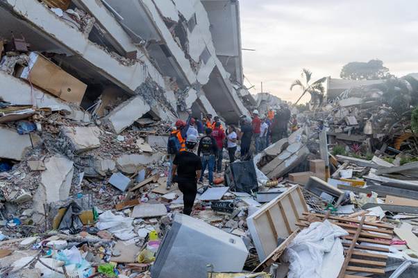
On 24th June 2026, two large shallow doublet earthquakes with magnitudes of 7.2 and 7.5 and depths of 20 km and 11.1 km, resp., struck northern Venezuela within 39 seconds of each other. The death toll at the time of writing is 3,811 with 16,740 injured, tens of thousands reported missing and 17,854 who have lost their homes. Roughly, 60,000 buildings were destroyed. USGS modelling for each shock predicts higher numbers of fatalities and significant economic loss of between 4 to 20% of Venezuela’s GDP. Our thoughts are with all those who have lost their lives, livelihoods, friends or homes, and also with those involved with the relief effort.
Fig 1: Photo of rescuers inLa Guaira, Venezuela, June 28, 2026. Attribution:U.S. Marines 24MEU by Cpl. Daniel Garcia, Public domain, via Wikimedia Commons
The first shock occurred 21 km ENE of San Felipe at 23:04:34 and the second occurred 20 km ESE of Yumare at 23:05:11. Because the earthquakes occurred such a short time period apart the deformation from each is hard to distinguish. Some organisations report them as a single event, e.g. INGV reports the earthquakes as a single event of magnitude 7.6 with two bursts of high energy release, having analysed the deformation from satellite data (Sentinel – 1). In the first burst, slip occurred along a 210 km by 30 km section of the fault ,moving with a velocity of 3 – 3.5km per second to north east of Caracus; it started with 2.5 m of slip t a depth of 20km near Morón. The second burst had a maximum slip of 3.6m north of Catia La Mar at a depth of 11.1km.
The earthquakes occurred on or near the San Sebastián fault system which is part of the larger Boconó– San Sebastián – El Pilar fault system. The Bonocó Fault is 500 km long strike slip fault located in the Eastern Ranges of northeastern Colombia and the Mérida Andes of northwestern Venezuela; it has been active since the Early Holocene. It is part of the boundary between the North Andes Plate and the South American Plate. The San Sebastián Fault Zone is 500 km long, located mostly offshore in the Caribbean Sea north of Venezuela. It is right-lateral strike-slip, forming part of the boundary between the Caribbean and South American tectonic plates. The El Pilar Fault System is 700 km long, located in state of Sucre in northern Venezuela. The fault system is of right-lateral strike-slip type with an east–west orientation and also forms part of the transform plate boundary between the Caribbean and South American plates.
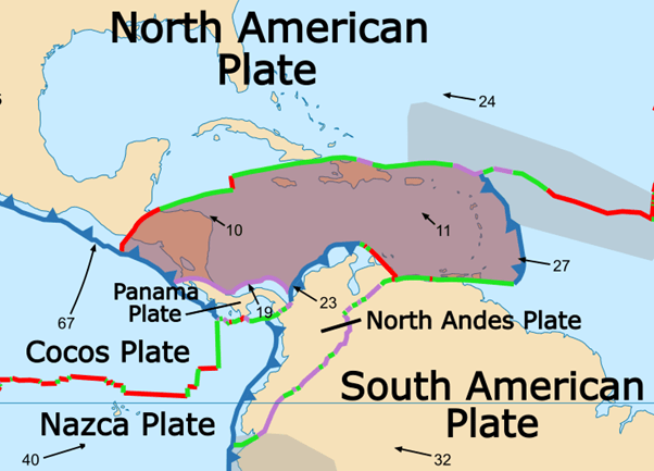
The South American Plate is moving west at a rate of 32 mm per year, the North Andes Plate north west at a rate of 23 mm per year and the Caribbean Plate north west at a rate of 11 mm per year. Because movement the Caribbean Plate is slower than the North Andes Plate, it subducts under the northwest margin of North Andes Plate; the North East margin is extensional. The boundary between the Caribbean Plate and South American Plate comprises transform faults.
Fig 2: Caribbean (brown shaded area) and surrounding plates by Alataristarion, published under CC BY-SA 4.0, via Wikimedia Commons.
The San Sebastian fault system has produced large earthquakes in the past. In 1812 the Caracas earthquake with magnitude 7.7 caused 15,000 to 20,000 fatalities. It is thought to have involved two sub-events, the first on the Boconó Fault and the second on the western part of the San Sebastián Fault. In 1900 San Narciso earthquake with magnitude 7.7 is thought to have been caused by rupture along the San Sebastián Fault to the east of Caracas. Before the recent earthquakes geophysicists had calculated that the accumulated slip deficit on the Bonocó fault could produce a 7.0 – 7.6 magnitude earthquake and likewise the San Sebastián fault might produce a 7.1 magnitude earthquake.
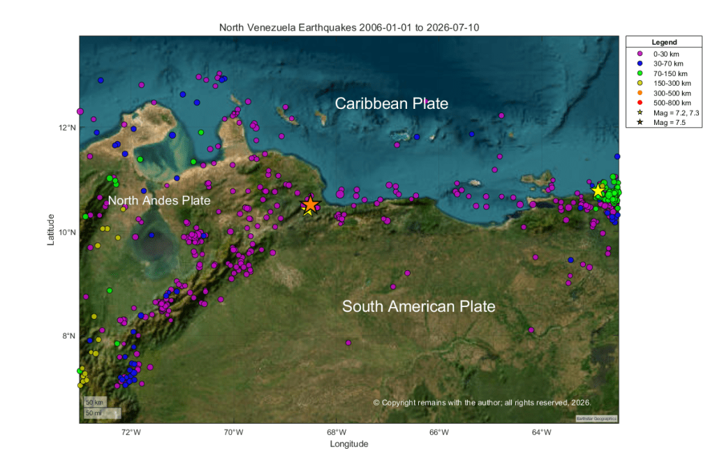
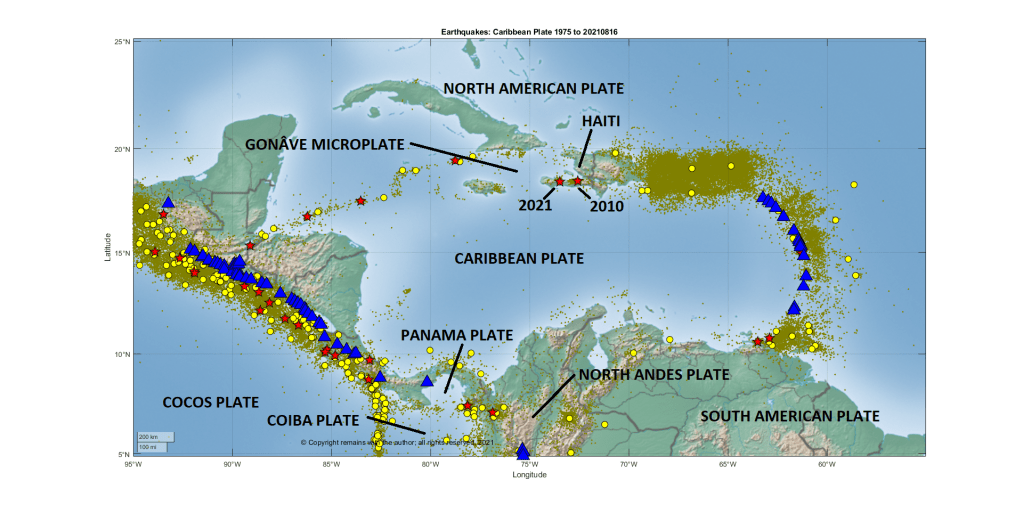
We have plotted the earthquakes between in the region between 15.0°N, 73.0 ° W and 7 ° N, 62.5 ° W from 1st January 2006 to 10th July 2026. In addition to the area of interest, this picks up part of the subduction of the Caribbean Plate under the North Andes Plate to the west of the plots and also the subduction of the South American Plate under the Caribbean Plate to the east of the plot. The latter includes a 7.3 magnitude earthquake at depth. Seismic activity in the area where the recent 7.2 and 7.5 earthquakes occurred tends to comparatively shallow, consistent with a transform plate margin.
Our first plot is a geoscatter plot. In this plot we can see that the doublet earthquakes occur near the junction of the three plates: Caribbean Plate, North Andes Plate and South American Plate.
Time to check out the current status of the volcanoes we have been following, especially as the situation has changed for some.
Askja
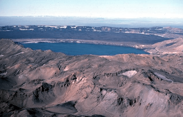
Fig 1: Image of Askja caldera by M Ryan, USGS, public domain.
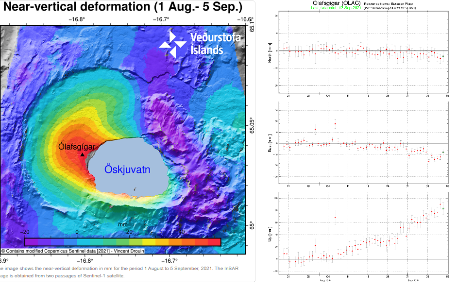
Inflation, thought to be caused by a magma intrusion at a depth of 2km-3 km, started in early August. GPS data and satellite images detected uplift of 5cm per month; the uplift centred on the western edge of the Öskjuvatn caldera.
The aviation code was raised to yellow on 9 September 2021, following near vertical uplift of 7cm.
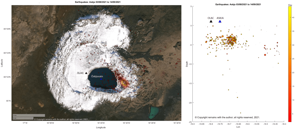
The epicentres of current earthquake swarm are mostly to the east of the Öskjuvatn caldera following a near linear route, starting at, or near, the area of maximum earthquake density for the period 1995 to 09.09.2021, and heading for the Viti explosion crater; seismic activity is on the opposite side from the area of maximum uplift.
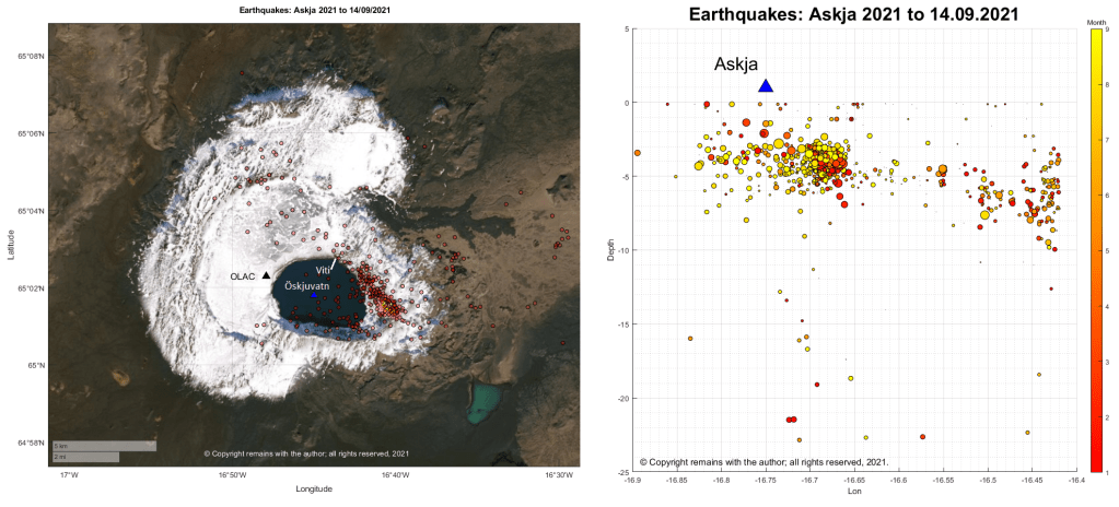
Seismicity for 2021 looks pretty similar; the current swarm follows the pattern of earlier seismicity.
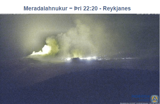
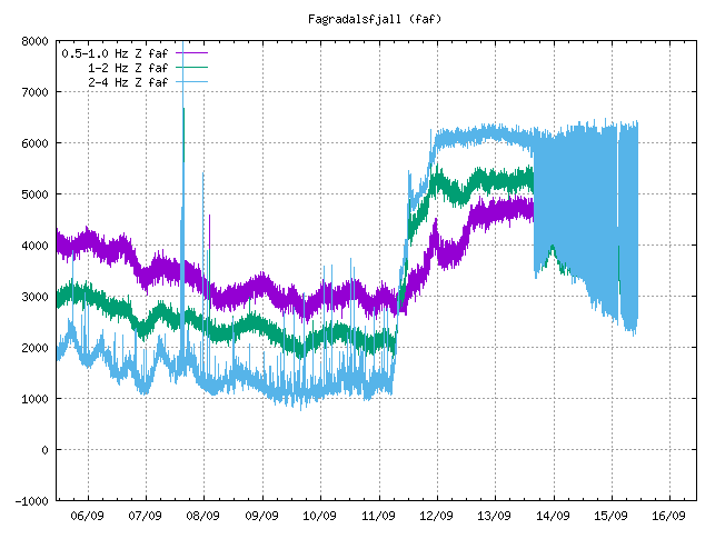
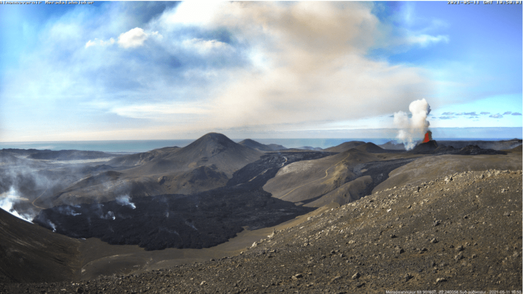
Fig 4a: Crater at Fagradalsfjall erupting on 14 September 2021.
The crater at fissure 5 has grown considerably since we last posted about it; it now dominates the surround hills. The eruption paused on 2nd September 2021, taking a well-earned break; steam and gas emissions continued. The eruption resumed a couple of days ago. The aviation code remains orange.
Fig 5: Merapi 2011 with Prambanan in the foreground, cropped from an image of Prambanan by Arabsalam, published under CC BY-SA 4.0. Source: Prambanan Java243. Prambanan is an 8th Century Hindu temple compound located approximately 17 kilometres (11 mi) northeast of the city of Yogyakarta and designated a UNECSO World Heritage Site.
Both lava domes situated below the south west caldera rim continue to grow, producing numerous pyroclastic flows and avalanches.
The alert level remains at thee and there is a 3km – 5km exclusion zone.
Grímsvötn
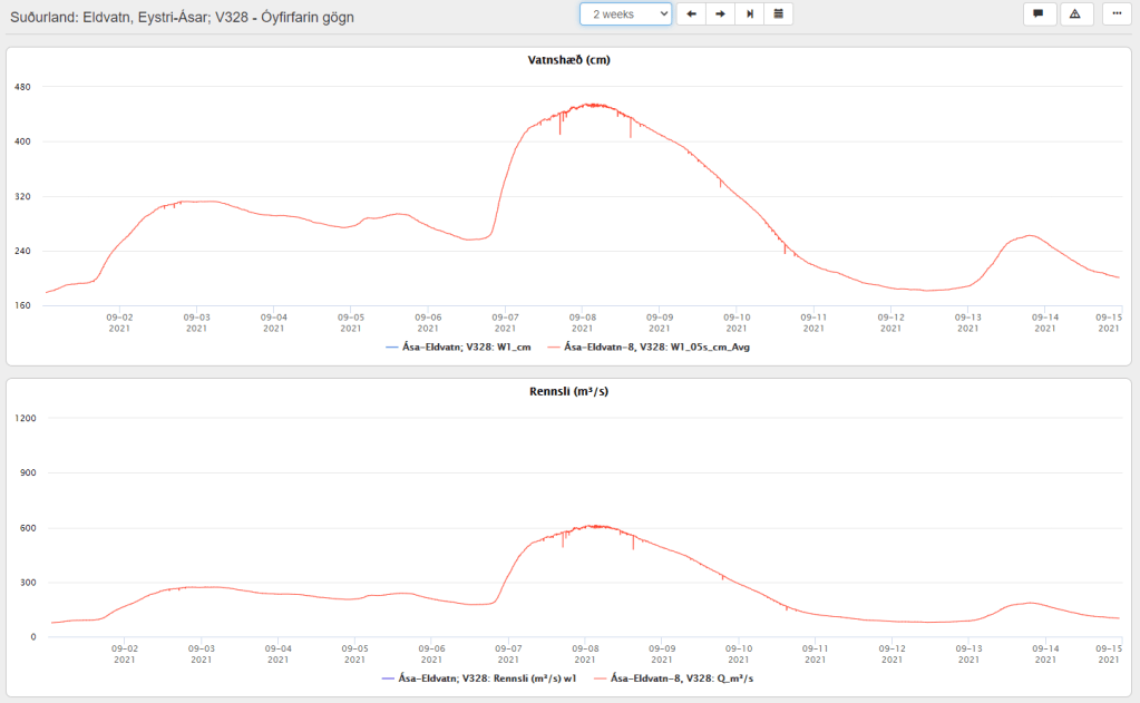
A jökulhlaup started on 1 September 2021 from the western Skaftlá caldera; the peak flow rate reached 520 m3/s on 2 September 2021. Warnings were issued of the hazard from H2S from water draining from the caldera lake. The ice-shelf had subsided 1m by 5 September 2021.
On 6 September 2021, the peak flow rate increased to 610 m3/s, thought to be due to a second release of water from the caldera lake – this time on the eastern side.
The aviation code remains at yellow.
Fig 6: Top image shows the water levels reached at Eldvatn and the lower one, flow rate. Source: IMO
La Soufrière St. Vincent
The last ash emissions were on 22 April 2021. Seismicity has since remained low. Gas and steam plumes have been observed rising from the crater.
The alert level remains at orange.
Mount Pelée
Volcano-tectonic earthquakes are still occurring in the edifice at depths between 0.2km to 1.2km. The area of discoloured, downgraded, burned and dead vegetation remains on the south west flanks.
At the end of July 2021 underwater gas emissions started between St Pierre and the Prêcheur. This will be investigated to ascertain how it links with the volcano.
The aviation code remains at yellow.
Mount Nyiragongo
The volcano is still active. A [gravitational] collapse in the crater caused and ash plume; ash reached Goma. Incandescence was seen on 26th July 2021 and a gas and ash plume emerged on 4th August 2021.
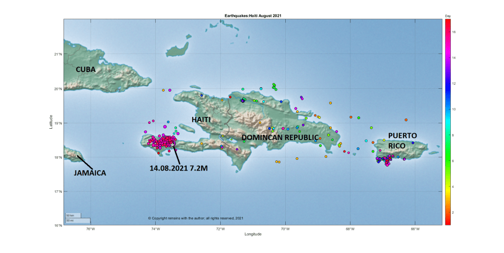
Our thoughts are with Haiti. Tragically, on 14 August 2021 at 8:29am (local time), a shallow (10km) earthquake of 7.2M occurred on the South West peninsula of Haiti 13 kilometres southeast of Petit Troup de Nippes. The earthquake was felt across the region, including Haiti, Dominican Republic, Jamaica, Cuba, and Puerto Rico. Over one million people may have been exposed to very strong or severe shaking.
A one-month state of emergency has been declared for Haiti. As of 16 August 2021, 1,419 are believed to have lost their lives, more than 6,000 injured and many thousands displaced. Tropical Depression Grace is likely to pass over the stricken area at the time of writing, bringing with it the risk of heavy rains, flooding, landslides and further loss of life.
Aftershocks are occurring, and may do so for some time. There is a small risk that this event is a foreshock to another event.
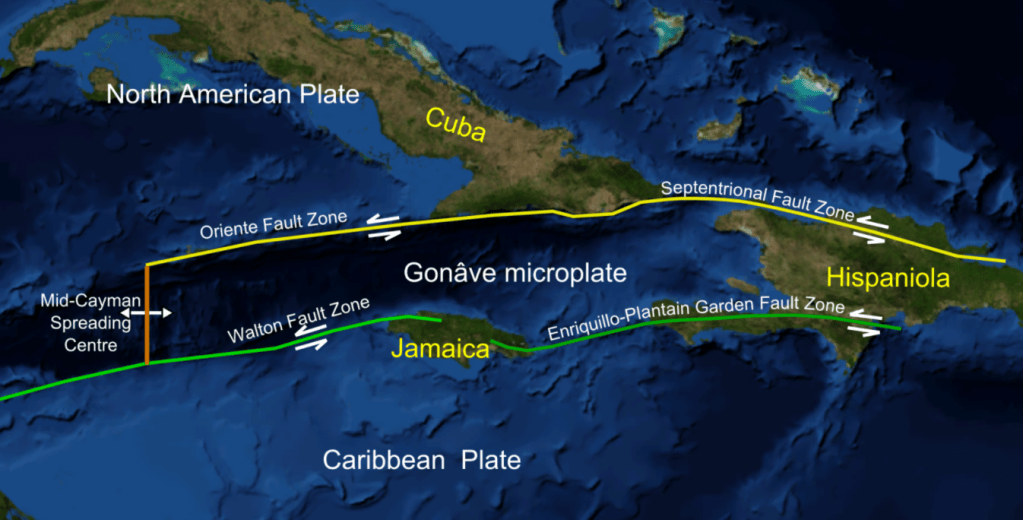
Haiti is located on the western side island of Hispaniola in the Greater Antilles Archipelago; the Dominican Republic occupies the eastern side of the island. Two large fault zones cross the island: the Septentrional-Orient fault in the north and the Enriquillo-Plantain Garden Fault Zone in the south.
Fig 2: Cropped image from one digitally altered by Mikenorton of the Gonâve Microplate (plate boundaries, main faults, islands and plates were added). Source: Gonâve microplate.
Hispaniola was formed from the collision of volcanic arcs with the North American Plate; the island is made up of 11 former island arcs. Haiti has an estimated population of 11.4 million (2018). The country is poor, politically unstable and yet to recover from the 2010 earthquake.
While the island has a volcanic past, there has not been any reported volcanic activity in the Holocene. There are two Pleistocene volcanoes in Haiti, the nepheline basalt scoria cones of Morne la Vigie, north of Port au Prince, and Thomazeau, east north east of Port-au-Prince, both of which were active around 1.5 million years ago; and, three in the Dominican Republic, the basaltic cinder cones of San Juan, trachyandesite lava domes and flows of the Dos Hermanos volcanic field and the rhyolitic to basalt Valle Nuevo volcanic field. The presence of picrite in the Duarte Complex in central Hispaniola and enriched basalts in southern Haiti are thought to be indicative of earlier hotspot activity
Tektites have been found in the Beloc Formation, Haiti, which are thought to have originated from the asteroid impact in Yucatán Peninsula, Mexico, which caused the K-Pg mass extinction event 66 million years ago.
2021 7.2 M Earthquake
The earthquake occurred in the Enriquillo-Plantain Garden Fault zone on the transform plate boundary between the Caribbean Plate and the North American Plate. The faulting mechanism for this earthquake indicates oblique thrust faulting along the fault zone. This fault zone accommodates 7mm per year of the 20mm per year of the relative plate motion. It is likely that this earthquake occurred in the same fault system as the devastating January 2010 7.0M earthquake which occurred near Port-au-Prince, the capital.
According to the DEC, the January 2010 earthquake not only caused significant loss of life and damage but also severally impacted Haiti’s government and infrastructure: 25% civil servants died, 60% government buildings, 80% schools in Port-au-Prince and 60% schools in the South and West departments were destroyed. In all, over 220,000 were killed, more than 300,000 injured and around 300,000 homes damaged or destroyed.
USGS note that four other large earthquakes are known to have occurred in the region: October 1751 in the Gulf of Azua at the eastern end of the Enriquillo-Plantain Garden fault zone; November 1751 at Plaine du Cul-de-Sac which destroyed Port-au-Prince; June 1770 which also destroyed Port-au-Prince; and, April 1860 which also caused a tsunami.
It is expected that there will be a request for international aid. If you wish to help / donate to the aid effort, refer to your favourite international aid agency, in the first instance.
At the time of writing the eruption at Fagradalsfjall is not only continuing unabated but getting stronger. After the opening of five new fissures, eruptive activity has focused on one crater, fissure 5. Lava now covers the Geldingadalur valley floor and threatens to engulf the first cones; lava has been flowing steadily into Meradalir since 24 April 2021.
Eruptive activity changed from continuous fountaining with effusive lava flows to periodic jetting after midnight on 2 May 2021. The change is thought to be due to degassing of the magma in the upper part of the eruption channel where a small chamber may have formed. Each jet is now accompanied by strong gas emissions. Lava flow, itself, is mostly being carried in lava channels under the crater rim, rather than ejected in the current jets so periodic jetting has not adversely impacted the output.
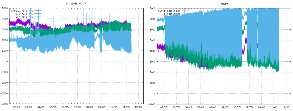
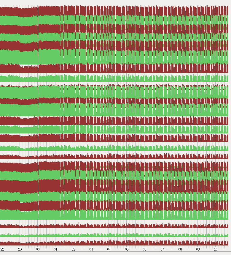
The onset of jetting can be seen in the tremor plots from local stations. We have included KRI because, being further away, we can see more of the lower frequency lines.
Fig 2: Tremor plots for KRI and MER showing the onset of jetting on 02 May 2021. Source: IMO
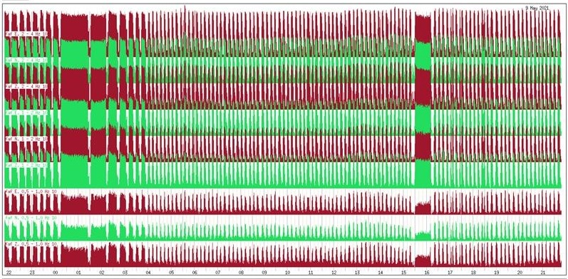
Fig 3: Unrest seen on seismometers near the eruption sites with pulses in volcanic activity from midnight on 2 May 2021. Source: IMO
Fig 4: This image shows the unrest on days 8-9. May. Source: IMO
Area of the Geldingadalsgos lava field: 1.78 Km2 (1.41Km2, 03 May 2021)
Volume of erupted lava: 30.7 million m3 (23.0 million m3, 03 May 2021)
Lava discharge rate: 12.9m3/s, (7.5m3/s, 03 May 2021)
Mg0: varies from 8.5 to 9.8
K20/Ti202 ratio: increasing from 0.1 to 0.3
In the first two weeks of the eruption lava flow decreased steadily from 7-8m3/s to 4-5m3/s. In the second two weeks, five new fissures opened with lava flow varying between 5 – 8m3/s. In the two weeks to 3 May 2021, one crater dominated with lava flow increasing. In the week to 10 May 2021, there has been a large increase in the output of lava to 12.9m3/s; the lava field now covers an area of 1.78km2 with a volume of 30.7 million m3. It is thought that the increase in output reflects changes in the lava channel from the mantle to the surface; it has widened over time.
Changes in chemical composition may mean that materials are mixing in the upper mantle before ascent or there is less partial mantle melt in the magma. If the latter, the eruption will end when the mantle source is sufficiently reduced.
Geldingadalsgos is still a toddler compared to Holuhraun; Geldingadalsgos’ eruption rate is 5% – 10% of the average eruption rate at Holuhraun between September 2014 and February 2015. Let’s hope it stays that way as it is a lot closer to residential areas.
La Soufrière St. Vincent
The alert status was lowered to orange after a period of relative quiescence on 6 May 2021; only a few long period events and volcano-tectonic earthquakes are occurring each day. People are allowed back into the orange zone but the red zone remains an exclusion zone.
The last explosive event was on 22 April 2021. However, a possible lava spine was spotted on photos on 27 April 2021. Tephra fills the crater, increasing the risk of pyroclastic flows should eruptive activity pick up again. In the meantime, lahars are the main hazard.
Mount Pelée
Mount Pelée remains on alert level yellow. Volcano tectonic events are occurring and seismic activity remains at above baseline level. An area of brown and dead vegetation was confirmed on 8 February 2021 caused by diffuse CO2 emissions; the vegetation has not recovered. The volcano is slowly reawakening.
This update is based on news reported from St Vincent and The Grenadines and Barbados up to 14 April 2021 (edited 16.04.2021).
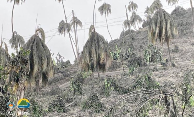
Fig 1: Ash covering vegetation in the red zone. Image by Prof. Richard Robertson, UWI-SRC.
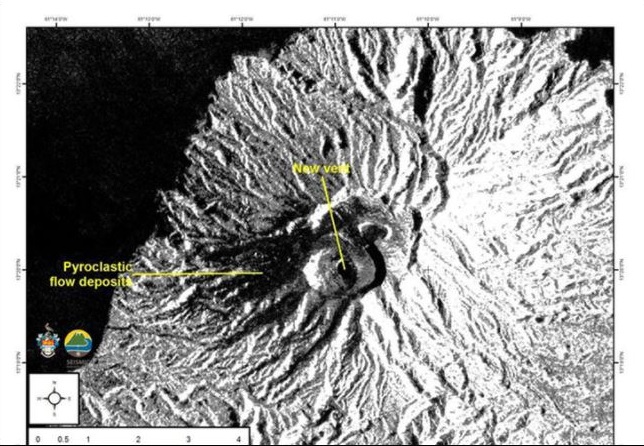
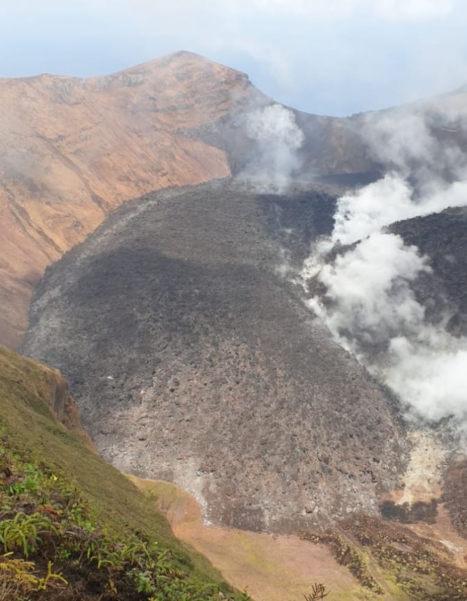
A new crater and vent were observed by satellites on 12 April 2021. Both lava domes have been destroyed.
Fig 2: Satellite image from the European Space Agency of the new crater and vent. The new vent and pyroclastic flows have been marked by UWI-SRC.
The North East of the island has been devastated; the agricultural area has been described by the Deputy Prime Minister of St Vincent & the Grenadines, Montgomery Daniel, as non-existent; trees and farms have been destroyed – only tree stumps are standing. He likens the damage to that caused by Hurricane Thomas. The crops lost include bananas, breadfruit, coconuts, mangos, soursop, plantains, arrowroot, dasheen and ginger and yams. The island’s economy is heavily dependent on the export of bananas and tourism.
Pyroclastic flows caused by ash columns collapse occurred on 13 April 2021, hitting the eastern side of the volcano. Areas at risk are Georgetown, Sandy Bay, Owia, Fancy and other settlements. Lahars have been reported by Sandy Bay.
Pyroclastic flows on 12 April were observed on the western and southern flanks of the volcano, reaching the sea at Morne Ronde, Larikai and Trois Lopues Bay.
Water supplies were contaminated by ashfall. The water supply has been restored to most of the island excluding the red zone (Owia, Sandy Bay, Fancy and Heritage), having cleaned ash out of the supply systems. Bottled water has been supplied from Barbados (although Barbados is suffering from ashfall as well). Several other nations have sent water. Water testing kits have been supplied by the World Health Organisation and Pan American Health Organisation.
Loss of power supplies were reported on 11 April 2021. No mention has been made of their status since. But it can be assumed that every effort would have been made to restore them.
Venezuela is providing humanitarian support. Guyana, Grenada and others have also sent supplies. Financial aid has been sent by other Caribbean islands, the UK (among others), the UN and the World Bank.
Barbados continues to get ashfall. The opening of schools has been delayed to allow for a cleaning up operation (ash got in via ventilators and windows). Ash has impacted water supplies in the north.
Explosions were occurring roughly 14 hours apart, with swarms of small long period earthquakes in between. It had been hoped that the explosive activity had waned for a while after a longer gap and that the continuing long period and hybrid earthquakes signified growth of a new lava dome, but another explosion occurred at 06:15 this morning (16.04.2021). SO2 levels indicate that fresh magma is arriving from a deeper source. The eruption is currently categorised as a VEI 4. It is expected to continue for some time, following the pattern of the 1902 eruption.
The United Nations have stated that this humanitarian crisis could go on for some time and that it may extend to other nearby islands.
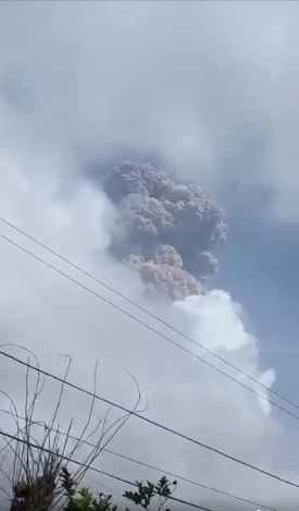
At the time of writing, there have been several explosive eruptions now from La Soufrière St. Vincent. The island has experienced extensive ashfall. The emergency evacuation has extended to the orange zone. Ash has reached 51,000 feet (38,000 feet, latest VAA) according to the volcanic ash alerts and the ash cloud has drifted over Barbados.
Fig 3: Ash plume from the first explosion. Photo from NEMO
Most of the new lava dome has been destroyed and the 1979 lava dome has suffered some damage. Removal of the rock has given magma a more open pathway. The eruption is expected to be larger than the 1979 eruption and to continue for some time; explosions are expected to be the same or greater magnitude. As far as we know, there have not been any pyroclastic flows but they are expected.
More than 3,000 people are in emergency accommodation and others are staying with friends or relatives. Saint Lucia, Grenada, Antigua and Barbados have offered to take refugees. Carnival Cruise Lines and the Royal Caribbean Group will send cruise ships to transport people to other islands. Venezuela has sent humanitarian aid and risk experts.
The north and west of Barbados have been hard hit by ash; the skies turned dark and ash is falling. Residents have been advised to stay indoors, except for essentials or a medical emergency. Beaches, parks and fish markets are closed for the time being. People with respiratory disorders have been advised to have their medication with them at all time. The airport and airspace is closed at the moment.
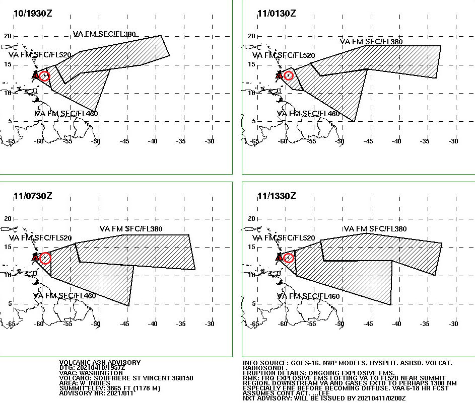
Latest VAA forecast:
Fig 4: Volcanic ash forecast from Washington VAAC Volcanic Ash Advisory (noaa.gov). The volcano is coloured in red and Barbados is in the red circle.
An explosive eruption started at La Soufrière St. Vincent around 12:40 pm GMT today, sending an ash column 8 km into the sky. The ash cloud reached 20,000 feet, drifting eastwards. Ashfall has been observed at Argyle International Airport.
Scientists warn that further larger eruptions are possible.
The evacuation from the red zone (northern end of the island) is still in progress at the time of writing.
Increasing gas emissions and seismic activity, including long period events, indicate that new magma is ascending at La Soufrière St. Vincent and an eruption could be imminent. An immediate evacuation order was given earlier today (c.1:00 am GMT) for the red zone in the north of the island, impacting 16,000 people.
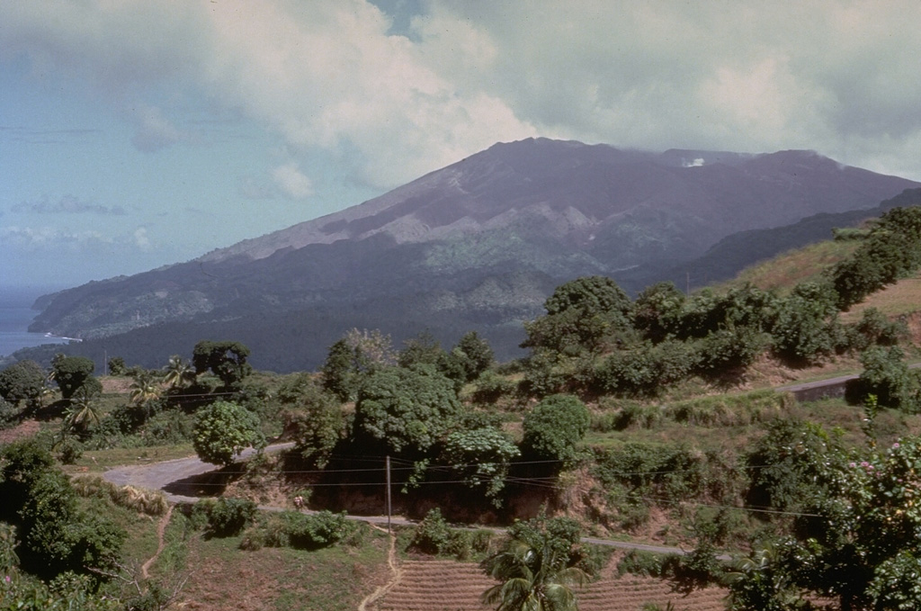
Fig 1: La Soufrière St. Vincent, seen here from the south. Photo by Richard Fiske, 1980 (Smithsonian Institution).
The new lava dome has been steadily growing since it emerged in December 2020. The emission of gas and stream from the centre of the dome and its border with the 1979 dome increased on 8 April 2021. A preliminary VAA noted that a well-defined hotspot was visible in the SW. Incandescence from the dome was visible in St Lucia.
A swarm of volcano-tectonic earthquakes started on 6 April 2021 beneath the volcano at a depth of around 6 km. Long period earthquakes have also been observed, indicating that new magma is ascending.
Fig 2: New lava dome on 19 March 2021 between the 1979 lava dome on the right of the image and the crater wall on the left. Photo NEMO.
Background
Volcanic activity, here, is driven by the subduction of the South American Plate under the Caribbean Plate.
La Soufrière St. Vincent is a 1,234m high stratovolcano located in the north of St. Vincent Island, which rides on the Caribbean Plate. She is the youngest volcano on the island. At the summit there is a 1.6 km wide crater with a younger crater formed in the 1812 eruption, located in a 2.2 km wide Somma crater. Her lavas are typical of a subduction zone setting: andesite / basaltic andesite and basalt / picro-basalt.
GVP records 23 Holocene eruptions, the largest of which were VEI 4s in 1812 and 1902. The 1902 eruption devastated much of the northern end of the island. A lava dome was extruded in the eruption of 1971, which was destroyed to be replaced by a new dome in 1979 in a series of explosive eruptions. The 1902 eruption devastated much of the northern end of the island. Pyroclastic flows from eruptions in 1812, 1902, and 1979 reached the coast.
For advice and the status of La Soufrière St. Vincent, please consult NEMO or follow their Face Book page (links below).
Thoughts with those impacted by the evacuation and eruption.
On 4 December 2020 the alert level for Mt. Pelée was raised to yellow due to increasing seismicity above background levels; and, on 29 December 2020 the alert level for La Soufrière St. Vincent was raised to orange following an increase in seismic activity, changes seen in the lake and fumaroles and a new growing lava dome emerging in the summit crater.
This led us to look into what drives volcanism in the area, notably the interaction of the Caribbean Plate with its surrounding plates.
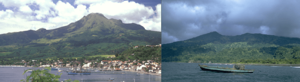
Fig 1: Mt. Pelée on the left with St. Pierre, photo by Lee Siebert, 2002 (Smithsonian Institution); Soufrière St. Vincent on the right, photo by William Melson, 1972 (Smithsonian Institution).
Mt. Pelée is famous for destroying the town of Saint- Pierre and its inhabitants plus visitors – a total of 29,000 people – in a matter of minutes on the morning of 8 May 1902 in a pyroclastic flow during a VEI 4 eruption. La Soufrière St. Vincent also erupted around the same time. Both volcanoes are located in the Lesser Antilles on the Caribbean Plate.
Mt. Pelée
Mt. Pelée is located on Martinique. She is a 1,400m high stratovolcano located in the caldera of an earlier volcano; edifice failures have breached the south west section of the caldera. Her lava types are andesite, basaltic andesite, dacite and basalt, picro basalt.
54 Holocene eruptions are recorded by GVP. Her historic eruptions include 1792 (VEI 1), 1851 (VEI 2), 1902 (VEI 4) and 1929 (VEI 3). Two lava domes were emplaced in the summit crater, l’Etang Sec, during the 1902 and 1929 eruptions.
1902 Eruption
Prior to the 1902 eruption, Mt Pelée’s known eruptions had been mild. Activity at the volcano started to ramp up gradually with fumaroles in the summit crater in 1889 to March 1902. From 23 April 1902 phreatic activity cleared out old rock, starting with minor explosive activity. By 4 May 1902 ash was raining down on Saint- Pierre. On 5 May, 23 people were killed when near boiling water from the crater heated by rising magma overran a distillery in a lahar in the Rivière Blanche valley.
On 6 May 1902, new lava emerged creating a lava dome. During 7 May 1902, small parts of the dome collapsed. At 07:50 on 8 May 1902, explosions were heard and a large black cloud seen to emerge and flow down the volcano, engulfing Saint-Pierre and some of the ships in the harbour. Most of the casualties were killed by hot gases and dust from the blast. Several pyroclastic flows followed: on 20 May 1902 a second pyroclastic current swept over Saint-Pierre destroying several of the remaining buildings; the Rivière Blanche valley saw several PDCs over the ensuing months; and, Morne Rouge was destroyed and 2,000 people killed by a pyroclastic current on 30 August 1902. During this activity a 300m lava spine emerged. After this eruptive activity continued until 1903. The lava spine has since been eroded.
Saint-Pierre had not been evacuated prior to 8 May 1902 for a couple of reasons: it was not known at the time that the volcano produced pyroclastic flows so the danger was not understood; and, an election was due on 11 May 1902, which politicians were keen should go ahead. No evacuation order was given.
When activity ramped up again prior to the 1929 eruption, people were evacuated in time.
La Soufrière St. Vincent
La Soufière St. Vincent can be found on St Vincent Island. She is a 1,234m high stratovolcano with crater lake and lava domes. The 1.6km wide summit crater is located on the south west edge of a 2.2km wide Somma crater; slope failure caused a breach in the Somma crater. Her lava types are andesite, basaltic andesite and basalt, picro basalt.
22 Holocene eruptions are recorded by GVP. Her historic eruptions include 1718 (VEI 3), 1812 (VEI 4), 1902 (VEI 4), 1971 (VEI 0) and 1979 (VEI 3). The 1902 eruption occurred on 6 May 1902, killing 1,680 people. The 1812 eruption produced a new crater, cutting through the summit crater. 1971 eruption extruded a lava dome in the summit crater, which erupted explosively in 1979 to be replaced by another dome.
Tectonic Setting
As noted above, both Mt. Pelée and La Soufrière St. Vincent are located on the Caribbean Plate in the Lesser Antilles. The Caribbean Plate is thick oceanic crust located between the North American and South American Plates. The northern boundary of the Caribbean Plate is a transform boundary with the North American plate, running from Central America to the Virgin Islands. The Gonâve microplate and Puerto Rico Trench form part of the northern boundary. At the eastern boundary, the South American Plate subducts under the Caribbean Plate in the Lesser Antilles. At the western boundary, the Cocos Plate subducts under the Caribbean Plate, forming the Central American Volcanic Arc. The southern boundary with the South American plate is a complex, comprising a convergent margin with the Panama Plate, a subduction zone with the North Andes Plate and a transform boundary with the South American Plate. The main plates velocities relative to the African Plate are noted below.
Plate
Direction
Velocity
North American Plate
West
25 mm per year
Cocos Plate
North east
67 mm per year
Caribbean Plate
North west
10 mm per year
Panama Plate
North west
19 mm per year
Coiba and Malpelo Plates
East
North Andes Plate
North west
23 mm per year
Nazca Plate
North east
40 -53 mm per year
South American Plate
West
27 – 34 mm per year
The origins of the Caribbean Plate are debated. There are two main theories which attempt to explain why the less dense but thicker crust of the plate overrides the Cocos and South American Plates. It may have evolved millions of years ago from the Caribbean large igneous province, formed at the Galapagos hotspot, drifting to its current location as the plates moved to accommodate the widening of the Atlantic Ocean. Alternatively, it may have formed from an old hotspot in the Atlantic. These theories are based on the relative motions of the plates. The first theory works on the basis that the Caribbean Plate is moving eastward compared to the North and South American Plates, whereas the latter uses the actual westward motion of the Caribbean Plate.
Recent Seismicity
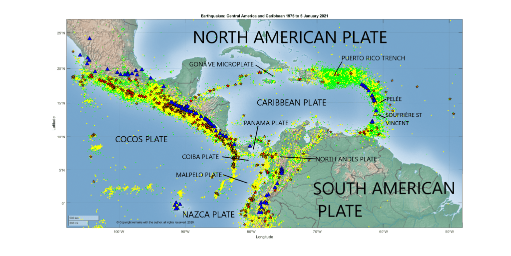
Yes, we’ve downloaded earthquakes for the region from USGS’s earthquake search, taking a larger area than the Caribbean Plate in order to pick up the subduction zones. In this case, it was not really necessary as most subduction is beneath the Caribbean Plate, but it was fun to find several microplates in the process: the Gonâve, Panama, Coiba and Malpelo Plates. The Malpelo Plate was first identified as late as 2017 by Tuo Zhang, Richard G Gordon et al of Rice University.
The coordinates selected were: 3.760°S, 107.051°W to 26.838°N, 48.867°W for earthquakes with magnitudes of 2.5 or more between 1 January 1975 and 5 January 2021. This picked up 80,751 earthquakes.
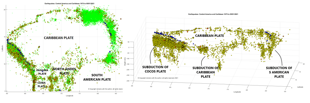
From Figs 2, 3 and 4 below, we can see the plate boundaries and the subduction zones on the western and eastern margins of the Caribbean plate are well marked by earthquakes and volcanoes; the subduction of the Caribbean Plate under the North Andes Plate is also visible (lower centre of the depth plot); and, the Puerto Rico Trench is also tectonically very active. The Puerto Rico Trench has produced some large earthquakes and tsunamis.
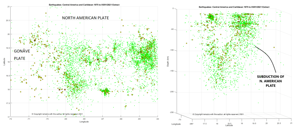
Fig 4 shows subduction of the North American Plate on the right of the depth plot. But there is also a line of earthquakes on the left of the plot which appears to indicate another subduction zone. Neither subduction zone here, despite being seismically active, has active volcanoes associated with it. It’s possible that there is another microplate here, but this is conjecture on our part until we can find an explanation or confirmation.
If you are interested or concerned by the alert statuses of Mt Pelée and La Soufrière St Vincent, you can find more information at L’Observatoire Volcanologique et Seismologique de Martinique, the National Emergency Management Organisation (NEMO) or GVP.
Hope you enjoyed our little tour. We will be looking in more detail at points of interest in the future.
Zhang, Tuo; Richard G. Gordon; Jay K. Mishra, and Chengzu Wang. 2017. The Malpelo Plate Hypothesis and implications for nonclosure of the Cocos-Nazca-Pacific plate motion circuit, 1. AGU Fall Meeting, New Orleans. Accessed 2018-06-06.
“Volcanoes”, Peter Francis and Clive Oppenheimer, Oxford University Press, Second Edition, 2004.

