Category Archives: La Soufrière St. Vincent

Update on Askja, Fagradalsfjall, Mount Merapi, Grímsvötn, La Soufrière St. Vincent, Mount Pelée, Mount Nyiragongo

Good Afternoon!

Time to check out the current status of the volcanoes we have been following, especially as the situation has changed for some.  
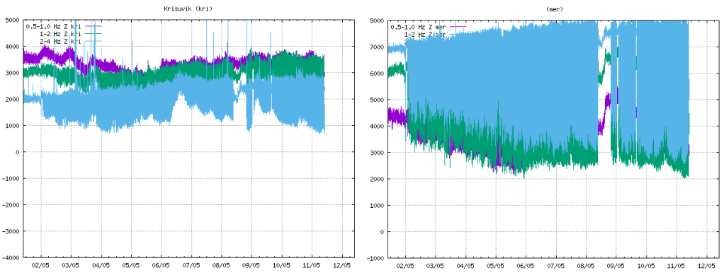
Askja

Fig 1: Image of Askja caldera by  M Ryan, USGS, public domain.

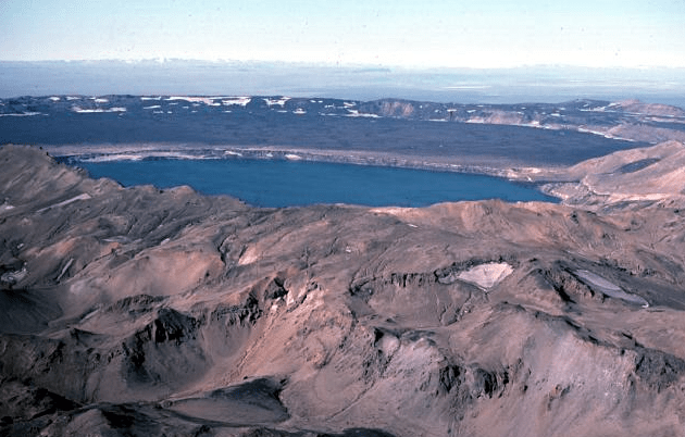
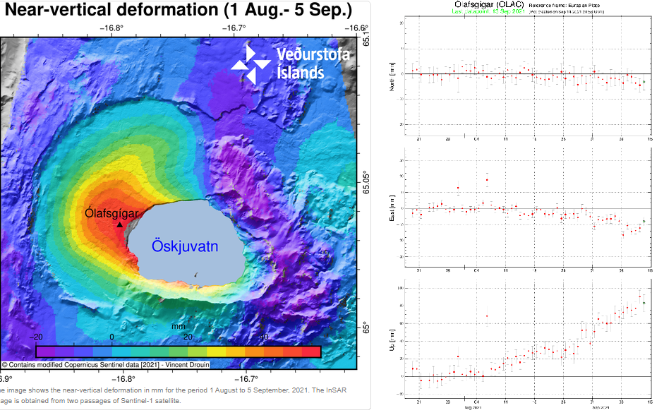
Inflation, thought to be caused by a magma intrusion at a depth of 2km-3 km, started in early August.  GPS data and satellite images detected uplift of 5cm per month; the uplift centred on the western edge of the Öskjuvatn caldera.

The aviation code was raised to yellow on 9 September 2021, following near vertical uplift of 7cm.

Fig 2: Deformation.  Sources: IMO and GPS tímaraðir (vedur.is)

We will take a quick look at local seismicity.  Raw earthquake data was downloaded from IMO for the period 1995 to 14.09.2021 for our plots.

Fig  3a: Left: Geodensity plot of earthquakes from 1995 to 09.09.2021, overlain with earthquakes from 03.08.2021 to 14.09.2021.  Right: scatter plot of earthquakes from 03.08.2021 to 14.09.2021 (colour denotes day from start).  All plots by the author. © Copyright remains with the author; all rights reserved, 2021

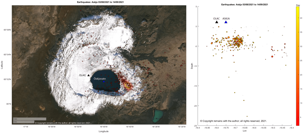
The epicentres of current earthquake swarm are mostly to the east of the Öskjuvatn caldera following a near linear route, starting at, or near, the area of maximum earthquake density for the period 1995 to 09.09.2021, and heading for the Viti explosion crater; seismic activity is on the opposite side from the area of maximum uplift. 

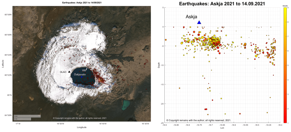
Seismicity for 2021 looks pretty similar; the current swarm follows the pattern of earlier seismicity. 

Fig  3b: Left: Geodensity plot of earthquakes from 01.01.2021 to 09.09.2021, overlain with earthquakes from 01.01.2021 to 14.09.2021.  Right: scatter plot of earthquakes from 01.01.201 to 14.09.2021 (colour denotes month).  All plots by the author. © Copyright remains with the author; all rights reserved, 2021.

More information on earlier seismicity can be found in our earlier article: Askja and Herðubreið, The Start of Our Exploration of the Northern Volcanic Zone, Iceland
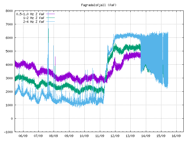
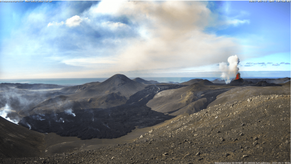
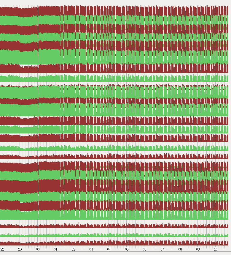
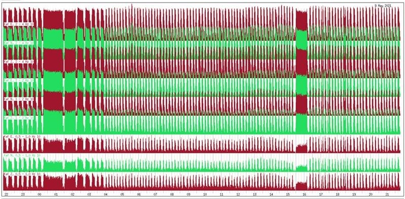
Fagradalsfjall

Fig 4a: Crater at Fagradalsfjall erupting on 14 September 2021. 

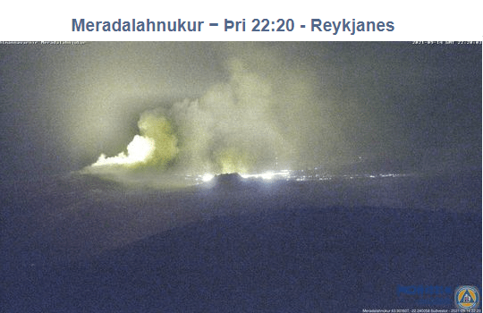
The crater at fissure 5 has grown considerably since we last posted about it; it now dominates the surround hills.  The eruption paused on 2nd September 2021, taking a well-earned break; steam and gas emissions continued.  The eruption resumed a couple of days ago.  The aviation code remains orange.
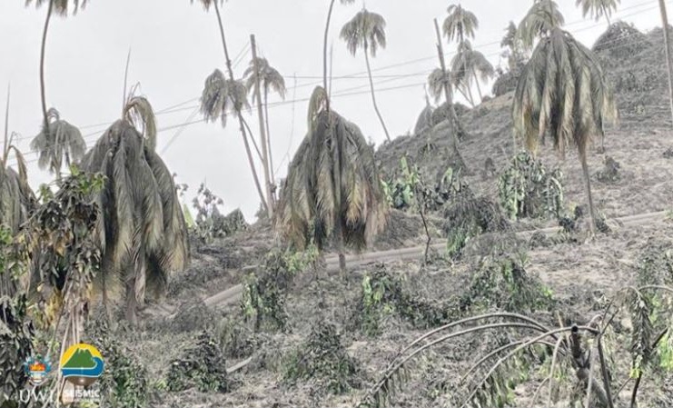
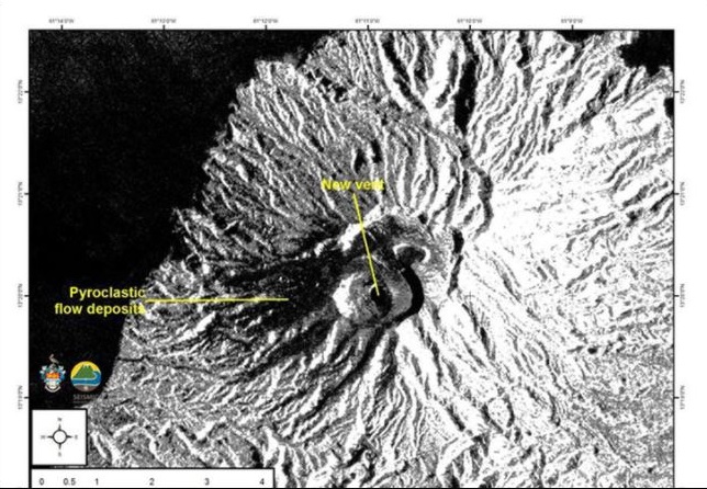
Fig 4b: Tremor plot, Fagradalsfjall (faf).  Source: IMO

Mount Merapi

Fig 5:  Merapi 2011 with Prambanan in the foreground, cropped from an image of Prambanan by Arabsalam, published under CC BY-SA 4.0.  Source: Prambanan Java243.  Prambanan is an 8th Century Hindu temple compound located approximately 17 kilometres (11 mi) northeast of the city of Yogyakarta and designated a UNECSO World Heritage Site.

Both lava domes situated below the south west caldera rim continue to grow, producing numerous pyroclastic flows and avalanches.

The alert level remains at thee and there is a 3km – 5km exclusion zone.
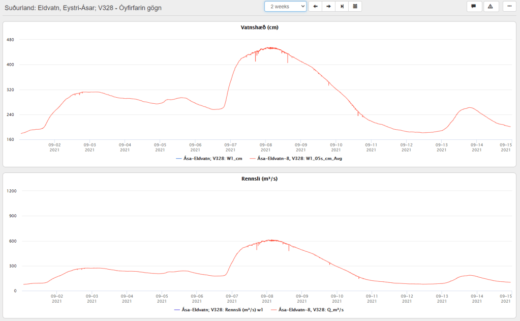
Grímsvötn

A jökulhlaup started on 1 September 2021 from the western Skaftlá caldera; the peak flow rate reached 520 m3/s on 2 September 2021.  Warnings were issued of the hazard from H2S from water draining from the caldera lake.  The ice-shelf had subsided 1m by 5 September 2021. 

On 6 September 2021, the peak flow rate increased to 610 m3/s, thought to be due to a second release of water from the caldera lake – this time on the eastern side.

The aviation code remains at yellow.

Fig 6:  Top image shows the water levels reached at Eldvatn and the lower one, flow rate.  Source: IMO

La Soufrière St. Vincent

The last ash emissions were on 22 April 2021.  Seismicity has since remained low.  Gas and steam plumes have been observed rising from the crater.

The alert level remains at orange.

Mount Pelée

Volcano-tectonic earthquakes are still occurring in the edifice at depths between 0.2km to 1.2km.  The area of discoloured, downgraded, burned and dead vegetation remains on the south west flanks. 

At the end of July 2021 underwater gas emissions started between St Pierre and the Prêcheur.  This will be investigated to ascertain how it links with the volcano.

The aviation code remains at yellow.

Mount Nyiragongo

The volcano is still active. A [gravitational] collapse in the crater caused and ash plume; ash reached Goma.  Incandescence was seen on 26th July 2021 and a gas and ash plume emerged on 4th August 2021.

Armchair Volcanologist

© copyright remains with the author; all rights reserved, 2021.

Sources:

The Smithsonian Institution’s Global Volcanism Program: GVP

Icelandic Met Office: IMO

Update on the eruptions at Fagradalsfjall and La Soufrière St Vincent, and status of Mount Pelée

Good Afternoon!

Fig 1: Image from Civil Protection / Webcam 11.05.2021

Fagradalsfjall

At the time of writing the eruption at Fagradalsfjall is not only continuing unabated but getting stronger.  After the opening of five new fissures, eruptive activity has focused on one crater, fissure 5. Lava now covers the Geldingadalur valley floor and threatens to engulf the first cones; lava has been flowing steadily into Meradalir since 24 April 2021.

Eruptive activity changed from continuous fountaining with effusive lava flows to periodic jetting after midnight on 2 May 2021. The change is thought to be due to degassing of the magma in the upper part of the eruption channel where a small chamber may have formed.  Each jet is now accompanied by strong gas emissions.  Lava flow, itself, is mostly being carried in lava channels under the crater rim, rather than ejected in the current jets so periodic jetting has not adversely impacted the output.

The onset of jetting can be seen in the tremor plots from local stations. We have included KRI because, being further away, we can see more of the lower frequency lines.

Fig 2: Tremor plots for KRI and MER showing the onset of jetting on 02 May 2021. Source: IMO
Fig 3: Unrest seen on seismometers near the eruption sites with pulses in volcanic activity from midnight on 2 May 2021.  Source: IMO
Fig 4: This image shows the unrest on days 8-9. May. Source:  IMO

Some stats as at 10 May 2021 (Source: Institute of Earth Sciences (hi.is))

  • Area of the Geldingadalsgos lava field: 1.78 Km2 (1.41Km2, 03 May 2021)
  • Volume of erupted lava: 30.7 million m3 (23.0 million m3, 03 May 2021)
  • Lava discharge rate: 12.9m3/s, (7.5m3/s, 03 May 2021)
  • Mg0: varies from 8.5 to 9.8
  • K20/Ti202 ratio: increasing from 0.1 to 0.3

In the first two weeks of the eruption lava flow decreased steadily from 7-8m3/s to 4-5m3/s.  In the second two weeks, five new fissures opened with lava flow varying between 5 – 8m3/s.  In the two weeks to 3 May 2021, one crater dominated with lava flow increasing.  In the week to 10 May 2021, there has been a large increase in the output of lava to 12.9m3/s; the lava field now covers an area of 1.78km2 with a volume of 30.7 million m3.  It is thought that the increase in output reflects changes in the lava channel from the mantle to the surface; it has widened over time.

Changes in chemical composition may mean that materials are mixing in the upper mantle before ascent or there is less partial mantle melt in the magma.  If the latter, the eruption will end when the mantle source is sufficiently reduced.

Geldingadalsgos is still a toddler compared to Holuhraun; Geldingadalsgos’ eruption rate is 5% – 10% of the average eruption rate at Holuhraun between September 2014 and February 2015. Let’s hope it stays that way as it is a lot closer to residential areas.

La Soufrière St. Vincent

The alert status was lowered to orange after a period of relative quiescence on 6 May 2021; only a few long period events and volcano-tectonic earthquakes are occurring each day.  People are allowed back into the orange zone but the red zone remains an exclusion zone.

The last explosive event was on 22 April 2021.  However, a possible lava spine was spotted on photos on 27 April 2021.  Tephra fills the crater, increasing the risk of pyroclastic flows should eruptive activity pick up again.  In the meantime, lahars are the main hazard.

Mount Pelée

Mount Pelée remains on alert level yellow.  Volcano tectonic events are occurring and seismic activity remains at above baseline level.  An area of brown and dead vegetation was confirmed on 8 February 2021 caused by diffuse CO2 emissions; the vegetation has not recovered.   The volcano is slowly reawakening.

Armchair Volcanologist

© Copyright remains with the author; all rights reserved, 2021.

Sources and Further Reading:

In the text and:

Iceland

Icelandic Met Office: https://en.vedur.is/ (English site)

Icelandic Met Office: https:// vedur.is/ (Icelandic site)

Reykjavik Grapevine: https://grapevine.is/

Department of Civil Protection and Emergency Management | Almannavarnir

La Soufrière St. Vincent

St Vincent and the Grenadines:  https://news784.com/

Barbados: https://www.nationnews.com/

Mt Pelée

Observatoire volcanologique et sismologique de Martinique (OVSM – IPGP): http://www.ipgp.fr/fr/ovsm/observatoire-volcanologique-sismologique-de-martinique-ovsm-ipgp

La Soufrière St. Vincent Eruption: The North East of St Vincent Island Has Been Devastated

Good Afternoon!

This update is based on news reported from St Vincent and The Grenadines and Barbados up to 14 April 2021 (edited 16.04.2021).

Fig 1: Ash covering vegetation in the red zone.  Image by Prof. Richard Robertson, UWI-SRC.

A new crater and vent were observed by satellites on 12 April 2021.  Both lava domes have been destroyed.

Fig 2: Satellite image from the European Space Agency of the new crater and vent.  The new vent and pyroclastic flows have been marked by UWI-SRC.

The North East of the island has been devastated; the agricultural area has been described by the Deputy Prime Minister of St Vincent & the Grenadines, Montgomery Daniel, as non-existent; trees and farms have been destroyed – only tree stumps are standing. He likens the damage to that caused by Hurricane Thomas. The crops lost include bananas, breadfruit, coconuts, mangos, soursop, plantains, arrowroot, dasheen and ginger and yams. The island’s economy is heavily dependent on the export of bananas and tourism.

Pyroclastic flows caused by ash columns collapse occurred on 13 April 2021, hitting the eastern side of the volcano.  Areas at risk are Georgetown, Sandy Bay, Owia, Fancy and other settlements.  Lahars have been reported by Sandy Bay.

Pyroclastic flows on 12 April were observed on the western and southern flanks of the volcano, reaching the sea at Morne Ronde, Larikai and Trois Lopues Bay.

Water supplies were contaminated by ashfall.  The water supply has been restored to most of the island excluding the red zone (Owia, Sandy Bay, Fancy and Heritage), having cleaned ash out of the supply systems.  Bottled water has been supplied from Barbados (although Barbados is suffering from ashfall as well).  Several other nations have sent water. Water testing kits have been supplied by the World Health Organisation and Pan American Health Organisation.

Loss of power supplies were reported on 11 April 2021. No mention has been made of their status since. But it can be assumed that every effort would have been made to restore them.

Venezuela is providing humanitarian support.  Guyana, Grenada and others have also sent supplies. Financial aid has been sent by other Caribbean islands, the UK (among others), the UN and the World Bank.

Barbados continues to get ashfall.  The opening of schools has been delayed to allow for a cleaning up operation (ash got in via ventilators and windows).  Ash has impacted water supplies in the north.

Explosions were occurring roughly 14 hours apart, with swarms of small long period earthquakes in between. It had been hoped that the explosive activity had waned for a while after a longer gap and that the continuing long period and hybrid earthquakes signified growth of a new lava dome, but another explosion occurred at 06:15 this morning (16.04.2021). SO2 levels indicate that fresh magma is arriving from a deeper source. The eruption is currently categorised as a VEI 4.  It is expected to continue for some time, following the pattern of the 1902 eruption.

The United Nations have stated that this humanitarian crisis could go on for some time and that it may extend to other nearby islands.

For updates, please use the sources below.

The Armchair Volcanologist

© Copyright remains with the author; all rights reserved, 2021.

Sources and Updates

St Vincent and the Grenadines:  News784 • St Vincent’s #1 News Source

Barbados: NationNews Barbados — nationnews.com