Sadly the death toll from Mount Semeru now stands at c.40 as of noon today (local time). Over 100 have been injured.
The lava dome collapsed from 1st to 6th December 2021 generating both lava and pyroclastic flows. The largest dome collapse occurred around 14:47 on 4th December 2021 to be followed by pyroclastic flows from 15:10, causing the fatalities. Rescue efforts have been hampered by later eruptive activity.
Fig 1: Image from 1985 eruption of Semeru, cropped from a photo by Tom Casadevall, 1985 (U.S. Geological Survey). Source: GVP
Sadly, 13 people have been killed, 7 missing and c. 100 injured, at the time of writing, following the collapse of the lava dome on Mount Semeru on 4 December 2021. Ash rose to a height of 50,000 feet, covering 11 villages. Flows of hot gas and lava travelled 800m at least twice on Saturday, reaching a nearby river. Two bridges were destroyed, including one connecting Lumajang to Malang. 900 people have been evacuated. 10 trapped in mines were rescued. Heavy rain and a thunderstorm had led to destabilisation of the lava dome. The volcano had been on alert level II (Waspada).
Mount Semeru is 3,657m high a stratovolcano with pyroclastic cones and fissure vents. Lake-filled maars follow a N-S trend cutting through the summit. She is located in the Lumajang district, East Java. Java lies above the subduction zone where the Indo-Australian Plate subducts under Sunda Plate . Her lavas are Andesite / Basaltic Andesite and Basalt / Picro-Basalt. Over 1m people live within 30km of the volcano.
GVP records 65 Holocene eruptions since 1818, which range from VEI 1 to VEI 3.
Time to check out the current status of the volcanoes we have been following, especially as the situation has changed for some.
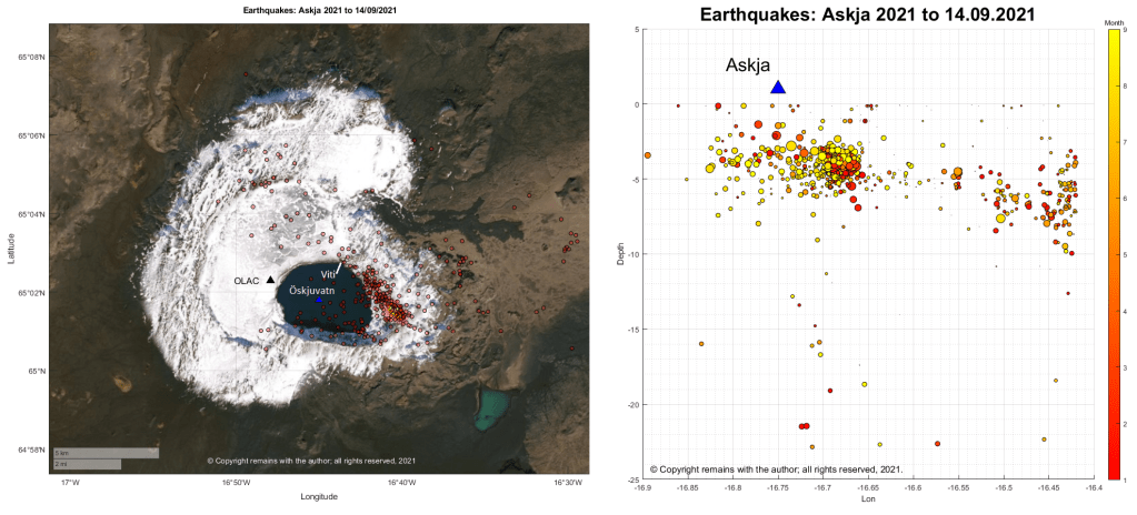
Askja
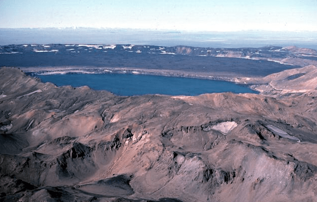
Fig 1: Image of Askja caldera by M Ryan, USGS, public domain.
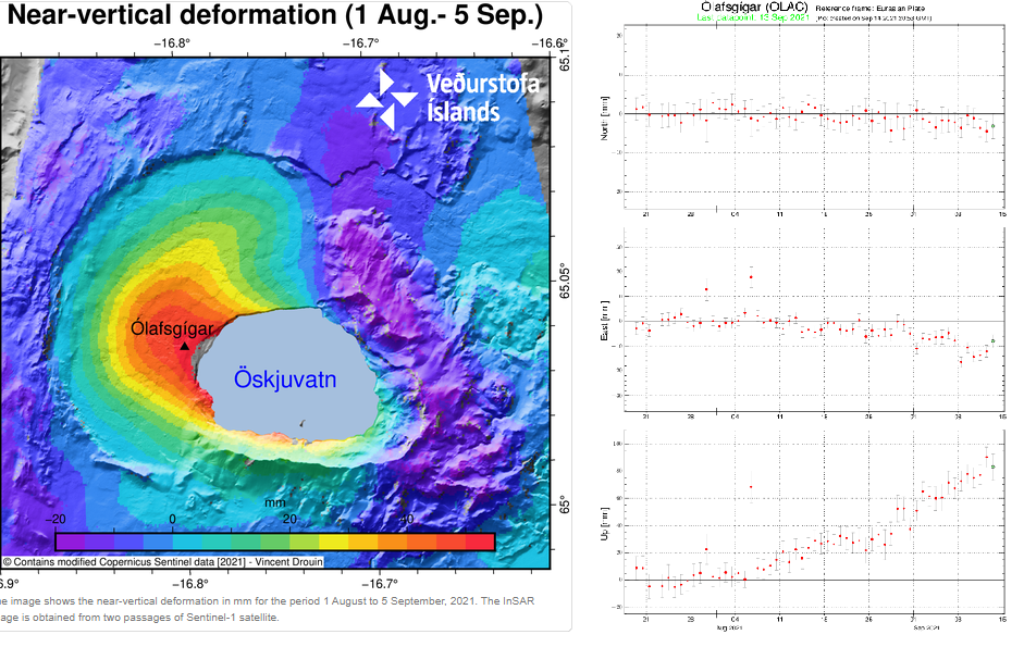
Inflation, thought to be caused by a magma intrusion at a depth of 2km-3 km, started in early August. GPS data and satellite images detected uplift of 5cm per month; the uplift centred on the western edge of the Öskjuvatn caldera.
The aviation code was raised to yellow on 9 September 2021, following near vertical uplift of 7cm.
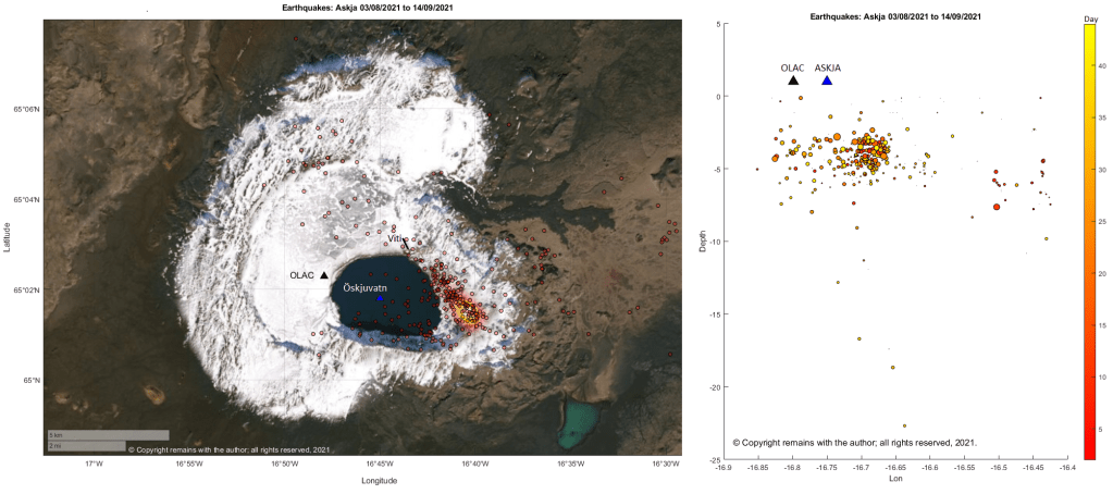
The epicentres of current earthquake swarm are mostly to the east of the Öskjuvatn caldera following a near linear route, starting at, or near, the area of maximum earthquake density for the period 1995 to 09.09.2021, and heading for the Viti explosion crater; seismic activity is on the opposite side from the area of maximum uplift.
Seismicity for 2021 looks pretty similar; the current swarm follows the pattern of earlier seismicity.
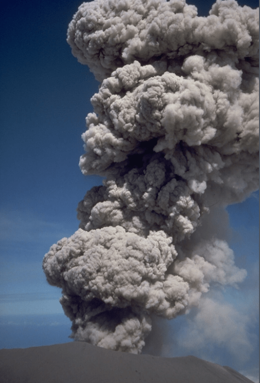
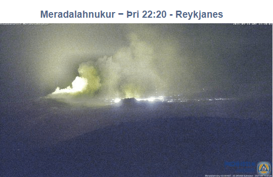
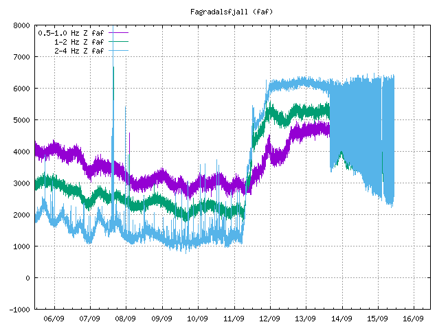
Fig 4a: Crater at Fagradalsfjall erupting on 14 September 2021.
The crater at fissure 5 has grown considerably since we last posted about it; it now dominates the surround hills. The eruption paused on 2nd September 2021, taking a well-earned break; steam and gas emissions continued. The eruption resumed a couple of days ago. The aviation code remains orange.
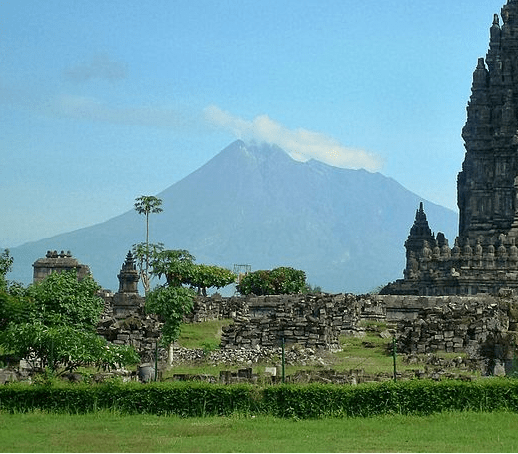
Fig 5: Merapi 2011 with Prambanan in the foreground, cropped from an image of Prambanan by Arabsalam, published under CC BY-SA 4.0. Source: Prambanan Java243. Prambanan is an 8th Century Hindu temple compound located approximately 17 kilometres (11 mi) northeast of the city of Yogyakarta and designated a UNECSO World Heritage Site.
Both lava domes situated below the south west caldera rim continue to grow, producing numerous pyroclastic flows and avalanches.
The alert level remains at thee and there is a 3km – 5km exclusion zone.
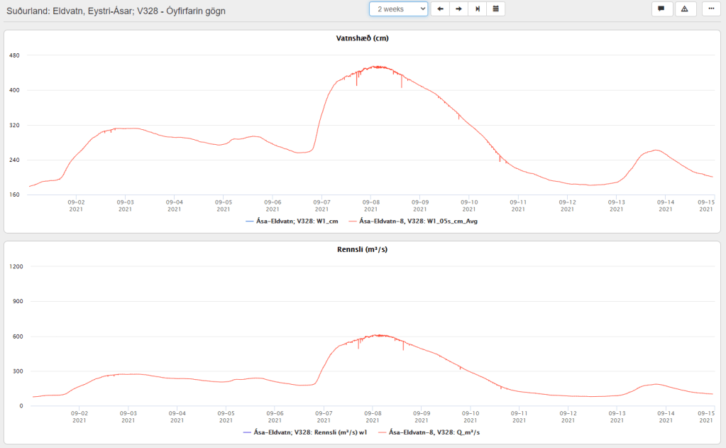
Grímsvötn
A jökulhlaup started on 1 September 2021 from the western Skaftlá caldera; the peak flow rate reached 520 m3/s on 2 September 2021. Warnings were issued of the hazard from H2S from water draining from the caldera lake. The ice-shelf had subsided 1m by 5 September 2021.
On 6 September 2021, the peak flow rate increased to 610 m3/s, thought to be due to a second release of water from the caldera lake – this time on the eastern side.
The aviation code remains at yellow.
Fig 6: Top image shows the water levels reached at Eldvatn and the lower one, flow rate. Source: IMO
La Soufrière St. Vincent
The last ash emissions were on 22 April 2021. Seismicity has since remained low. Gas and steam plumes have been observed rising from the crater.
The alert level remains at orange.
Mount Pelée
Volcano-tectonic earthquakes are still occurring in the edifice at depths between 0.2km to 1.2km. The area of discoloured, downgraded, burned and dead vegetation remains on the south west flanks.
At the end of July 2021 underwater gas emissions started between St Pierre and the Prêcheur. This will be investigated to ascertain how it links with the volcano.
The aviation code remains at yellow.
Mount Nyiragongo
The volcano is still active. A [gravitational] collapse in the crater caused and ash plume; ash reached Goma. Incandescence was seen on 26th July 2021 and a gas and ash plume emerged on 4th August 2021.
Today we are taking a trip to Java, Indonesia, away from the gentle effusive eruption at Fagradalsfjall, Iceland, and what looks like the growth of a shield volcano, to the more explosive activity at the subduction zone between the Indo-Australian Plate and the Sunda Plate, focussing on Gunung Merapi.
Merapi has been erupting since the start of the year, with the growth of two lava domes, block and ash falls and pyroclastic flows generated from partial collapses of the lave domes. The current alert level is 3 (Siaga) and the aviation code is orange. (Siaga translates as, using Google Translate, “Stand By” (There was a significant increase in volcanic activity. Eruption is most likely to occur and the area of potential eruption hazard is in the area of Disaster-Prone Areas (KRB) II. The community is prohibited from carrying out activities in the KRB II area). The exclusion zone extends 5km from the summit).
Fig 1: Merapi 2011 with Prambanan in the foreground, cropped from an image of Prambanan by Arabsalam, published under CC BY-SA 4.0. Source: Prambanan Java243. Prambanan is an 8th Century Hindu temple compound located approximately 17 kilometres (11 mi) northeast of the city of Yogyakarta and designated a UNECSO World Heritage Site.
Background
Merapi is a 2,968 m high stratovolcano located 25 km north of the city of Yogyakarta on the island of Java, Indonesia. Volcanic activity at Merapi is believed to have started around 170,000 years ago. Since then, activity alternated between effusive and explosive, the latter with lava domes and pyroclastic flows. While her eruptions are comparatively modest (VEI 1 to 4), her proximity to a large metropolis means she has the potential to do a lot of damage, hence her status as a Decade Volcano. Over 4 million people live within 30 km of the volcano and over 24 million people live within 100 km of the volcano.
Yogyakarta, itself, is a densely populated city in the Special Region of Yogyakarta. 373,589 people live in the city (Census 2020) and over 4 million in the metropolitan area. It is a sophisticated centre for Javanese fine arts, culture and education. Yogyakarta has been home to the seat of power for the Medang Kingdom between the 8th and 10th century and Mataram Sultanate between 1587 and 1755. Explosive eruptions from Merapi, which destroyed many Buddhist and Hindu temples built between 732 AD and 900 AD (and presumably caused other significant damage), may have been a factor in the migration of the Mataram Kingdom to East Java in 928 AD or 929 AD.
Tectonic Setting
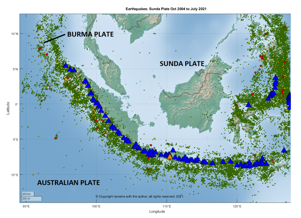
Volcanic activity on Java is driven by the northward subduction of the Australian Plate under the Sunda Plate at the Sunda Trench. The western, southern and eastern boundaries of the Sunda Plate are tectonically very active.
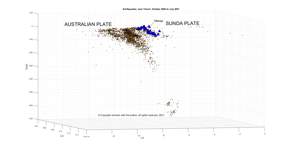
We downloaded earthquake data from EMSC for the period October 2004 to July 2021 between 14.04°S 86.16°E to 12.66°N 127.48°E to take a look. This area is larger than the area under discussion to make sure that subduction zone was captured. The following images are from extracts of that data.
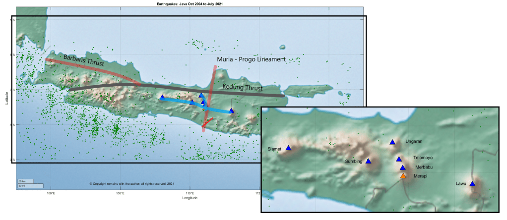
Merapi is located at the intersection of two volcanic lineaments: the north – south trending Ungaran-Telomoyo-Merbabu-Merapi; and the east – west trending Lawu – Merapi – Sumbing – Sindoro – Slamet. Ungaran-Telomoyo-Merbabu-Merapi is a double chain volcanic arc, with Ungaran as the back arc and Telomoyo-Merbabu-Merapi as the trench side volcanoes. Merapi is also bounded by two faults: the north – south Merapi – Merbabu fault and the Baribis – Semarang – Kendeng fault.
Merapi formed in the late Pleistocene and Holocene in three stages: Proto-Merapi, Old Merapi and New Merapi.
Proto-Merapi emerged after 170 ka and includes Gunung Bibi, dated to 190 ± 60 ka, Gunung Turgo, 138 ± 3 ka, and Gunung Plawangan ,135 ± 3 ka.
Gunung Plawangan was home to a volcano observatory until the 1990s but was abandoned due to nuée ardentes from the current cone.
The summit of Gunung Turgo is home to sacred graves including that of Sheikh Jumadil Qubro, a direct descendant of the Islamic prophet, Muhammad.
Old Merapi started to grow around 30 ka, reaching a height slightly more than the current cone; growth ended with flank failures 4.8 ± 1.5 ka. Collapse of the caldera with debris avalanche flows to the south and west left a Somma rim on the eastern slope.
Gunung Batulawang and Gunung Kendil are part of Somma – Merapi. Gunung Batulawang is the highest peak of Old Merapi. Lake Borobudur formed c 3,400 14C years BP.
The latest Somma collapse was around 1,900 14C years BP.
New Merapi, the current cone, grew soon after the growth of Old Merapi ended. Partial edifice collapse of New Merapi may have occurred 1,130 ± 50 14C years BP.
Gunung Selokopo Ngisor, Gunung Pusunglondon, Gunung Patukalapalap, Gunung Dengkeng, Gungung Selokopo Duwur and Gunung Gadjah Mungkur are hills which are thought to belong to New Merapi.
Volcanic Activity
Merapi’s lavas are typical for a subduction zone, being andesite / basaltic andesite, trachyandesite, basaltic trachyandesite with some basalt / picro basalt and trachybasalt / tephrite basanite. Her lavas have evolved over time. Her early lavas were effusive basaltic. The K2O content of the lava has increased over time; Old Merapi had lower K2O lavas than New Merapi and nearby Gunung Telomoyo and Gunung Merbabu.
According to GVP, there have been 111 Holocene eruptions, ranging from VEI 1 to 4. The most recent eruption, currently a VEI 1, started on 31 December 2020, with new lava domes extruded in January and February 2021, and, at the time of writing is ongoing. The most recent VEI 4 was the devastating October 2010 to July 2012 eruption in which partial dome collapse caused pyroclastic flows that destroyed villages, led to the evacuation of more than 300,000 people and caused 386 fatalities; the ash plume reached 18km between 4-6 November; and, the largest pyroclastic flows occurred on 26 October 2010 and 5 November 2010 – the latter produced the widest pyroclastic flow seen in Indonesia for 100 years. By mid-November, eruptive activity subsided, to be followed by lahars as the main hazard.
The 26 October eruption started 19 hours after tsunamis caused by earthquakes on the Sunda Trench swept away villages on the Mentawai Islands, killing 428 people and displacing thousands. The earthquakes were a 7.7 M, preceded by a 5.8 M and followed by aftershocks that included a 6.1 M and 6.2 M. Whether or not the earthquakes triggered the eruption, itself, is open to debate; the volcano was ready to erupt. Since 2007 swarms of volcanic earthquakes had been occurring; deformation and gas emissions increased in September 2010; and, seismicity increased between 15 – 26 October, ramping up during 20 – 26 October. The alert levels were raised to level 2 on 20 September 2010, level 3 on 21 October 2020 and level 4 on 25 October 2020.
A phreatic eruption on 11 May 2018, heralded a new phase of lava dome growth. In November 2020, evacuations were ordered due to decreasing stability of the lava dome. Eruptions commenced on 4 January 2021, leading to further evacuations in the Yogyakarta region.
Here’s hoping the current eruption remains a VEI 1.
The Smithsonian Institution’s Global Volcanism Program (GVP): Merapi
Ralf Gertisser, Silvain J. Charbonnier, Jörg Keller, Xavier Quidelleur, “The geological evolution of Merapi volcano, Central Java, Indonesia”, Bulletin of Volcanology (2012) 74: 1213=1233. DOI: 10.1007/s00445-012-0591-3
Newhall, C. G., Bronto, S., Alloway, B., Banks, N. G., Bahar, I., del Marmol, M. A., Hadisantono, R. D., Holcomb, R. T., McGeehin, J., Miksic, J. N., Rubin, M., Sayudi, S. D., Sukhyar, R., Andreastuti, S., Tilling, R. I., Torley, R., Trimble, D., Wirakusumah, A. D., “10,000 Years of explosive eruptions of Merapi Volcano, Central Java: archaeological and modern implications”, Journal of Volcanology and Geothermal Research 100 (2000) 9 – 50. DOI:10.1016/S0377-0273(00)00132-3
Krakatau’s VEI 6 eruption of 1883 is the next in our series of famous eruptions. We have also included a summary of birth of Anak Krakatau from the caldera, and the December 2018 cone collapse and resulting tsunami.
The 1883 eruption is not only famous for the catastrophic destruction of Krakatau Island, pyroclastic flows, global cooling, devastating tsunamis and a death toll of between 36,164 to 120,000 people, but it is also the first major eruption to have been reported globally by telegraph. A typo in the telegraph led to the west calling the volcano Krakatoa.
The 2018 eruption, cone collapse and tsunami are well-documented by various sources. Our go-to resource here was primarily GVP.
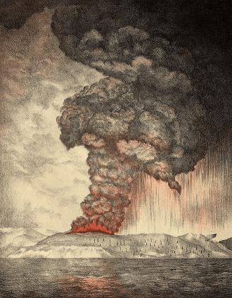
Fig 1: Lithograph: Parker & Coward, Britain. 1888. Public Domain
Geological Setting
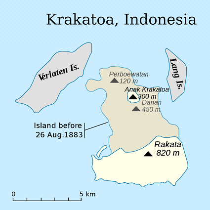
Katakatau lies to the west of the Sunda Strait between Sumatra and Java. It is the site of a much larger 7 km wide caldera which may have been formed during eruptions in 416 AD or 535 AD. The edges of the caldera are marked by Verlaten and Lang Islands.
Before the 1883 eruption, Krakatau was a 9 km long verdant, wooded island formed from three volcanoes, Rakata, Danan and Perbuwatan in the caldera. Another small island in the group was Polish Hat. The islands were uninhabited but used by local fishermen, woodcutters and the Dutch and British navies.
Fig 2: Map by ChrisDHDR showing Krakatau Island before the eruption and the site of Anak Krakatau, Public Domain
Eruptive History
GVP records 56 known Holocene eruptive periods for Krakatau, of which only 10 precede the 1883 eruption. The evidence for the 10 is historical observations from 250 AD to 1684, so perhaps earlier activity has been lost under the debris from more recent events. Activity after 1883 relates to building of Anak Krakatau.
The 535 AD eruption of Krakatau may have caused the volcanic aerosol veil that dimmed the Sun (filtered out sunlight) for eighteen months, causing crop failures, cooling and hiding Canopus, a bright star used by Chinese astronomers to mark the seasons – more likely if the eruption was a large caldera forming event. The other contender (preferred by some) is the 408 AD – 536 AD Tierra Blanca Joven eruption of Ilopango, El Salvador. On the other hand, why exclude one? Both may have contributed in some way.
Krakatau’s lavas are typical of a subduction zone: andesite, basaltic andesite, dacite, trachyte and trachydacite; and, also basalt and picro basalt. The last mentioned indicates that there may be more rapid magma ascent through extensional faulting in the area.
The 1883 Eruption: 100 Days of Activity
The Intro
The only known precursors to the 1883 eruptions are a large earthquake on 1 September 1880 followed by a period of increasing seismicity. Unfortunately, the area is seismically very active, being near the convergent margin between the Sunda Plate and the descending Indo-Australian Plate so, without modern instrumentation, there was insufficient information to interpret escalating events.
On the 20 May 1883 eruptive activity started at the Perbuwatan crater with series of loud explosions audible 150 km away. Light ashfall covered the area and a column of steam was visible. Activity continued for a few days then calmed down enough for a party to charter a boat to the island on 27 May 1883; they were the only witnesses to the Perbuwatan crater, then about 1 km in diameter, 50 m deep, with a small pit generating a steam column and small explosions every 5 to 10 minutes. By the end of June 1883, the summit of Perbuwatan had been destroyed and a second eruption column was visible at the centre of the island.
Captain Ferzenaar, a surveyor for the Dutch government, collecting ash samples on 11 August 1883, found a thick covering of tephra, all vegetation stripped bar a few tree trunks; three active eruption columns (one at Perbuwatan and the other two near the centre of the island); and, at least eleven other sites with some activity. However, upwind of the eruption, he was unable to see more beyond the steam and ash.
The Cataclysmic Eruption
The main event occurred over 26 and 27 August 1883. There were very few survivors so it took while for Dutch investigators, led by Rogier D.M. Verbeek, a mining engineer and geologist, and British investigators from the Royal Society to reconstruct the events. Their information came from various sources, including ships caught in the Sunda Strait, pressure gauges at the Batavia gasworks on Java, Dutch officials living in Batavia and Buitenzorg, and requests for information from the Royal Society for data further afield, including one printed in The Times.
Three days before 26August, there had been a marked increase in activity on the island. By 13: 00 on 26 August explosions were loud enough to be heard 150 km away. By 14:00 a 25 km high black eruption column was visible. By 17:00 activity was audible throughout Java and pumice was raining down on vessels in the Strait. By 19:00 a Plinian eruption column with intense volcanic lightening was witnessed. Several ships were among those caught up in the eruption, one of which, the Charles Bal, trapped by poor visibility had to sail within sight of the volcano to keep its bearings amid hot ash fall, volcanic gases, lightening and St Elmo’s Fires (static electricity which lit up the mastheads).
The eruption escalated on 27 August with large explosions at 05:30, 06:44, 10:02 and 10:52 in the morning (local time). The noise from these woke people 3,224 km away in Australia; and, further away at a distance of 4,811 km, it was confused with gunfire. Atmospheric pressure changes were detected globally. These explosions generated a 40 km high Plinian eruption column that cut out the sun for up to two days in the vicinity; further away in Batavia, full loss of light lasted for just over an hour and a half. There is some debate on what caused the large explosions, including the possibility of sea water reaching either the magma chamber or ascending hot magma.
Pyroclastic density currents (PDCs) made it to southern Sumatra, killing 2,000 people. The inhabited islands of Sebesi and Sebuku between Krakatau and Sumatra were devastated, with no survivors. Hot ash from the PDCs burned people as far away as Kalimbang, Sumatra.
The tsunamis caused the most of the remaining fatalities (estimates of the total number of fatalities vary from c. 36,000 to 120,000). A series of tsunamis devasted the shores of the Sunda Strait; waves reached a height of 25m on the coast of Sumatra and 40m on Java. The town of Anjer was washed away. The largest tsunami wave at Batavia was detected at 12:36 on 27 August. The waves reached as far as Auckland, New Zealand. The tsunamis may have been caused by displacement of large amounts of seawater from the rapid deposit of ash in the caldera form discrete explosions, collapse of the eruption columns or edifice collapse. As you will see later, the edifice failure of Anak Krakatau in December 2018 caused a catastrophic tsunami.
The eruption calmed down after the four large explosions, with some outbreaks of minor activity, to be quiet after 28 August 1883.
The Immediate Aftermath
Two thirds of Krakatau Island had disappeared – either blown apart by the eruption or sunk as part of the creation of a 300m deep caldera; only the southern section of Rakata remained. Pumice and a small rock were all that remained of the northern part of the island.
20 km3 of dacite pyroclastic material had been erupted as tephra, pyroclastic density currents and the rest deposited into the sea and on surrounding islands. Deposits enlarged Verlaten and Lang Islands and two new islands were formed: Steers and Calmeyer. Polish Hat, however, had disappeared. Steers and Calmeyer were later eroded by sea water.
The 40 km high eruption column had reached into the stratosphere, where ash was spread round the globe, initially in the tropics but then migrating northwards and southwards, lingering for a couple of weeks. Aerosols filtered sunlight resulting in vivid sunsets; the sun is reported as appearing as green or blue, depending on its angle in the sky. Filtering of the sunlight caused global cooling probably in the order of 0.34°C in 1884.
The Birth, Collapse and Regrowth of Anak Krakatau
Krakatau has remained active with over 40 eruptive episodes since the 1883 eruption. Anak Krakatau (Child of Krakatau) emerged in 1927 from the caldera and had reached a height of 338m by 2018, only to lose a large part of the new cone in December 2018 when a relatively small eruptive episode (VEI 3), which started in June 2018, caused edifice failure. The edifice collapse was preceded by an eruption at 21:03. Øystein Lund Andersen, a photographer, recorded that by 21:05 a dark plume obscured the volcano and earlier incandescence. At 21:27 the first tsunami wave hit the shore, travelling 15m inland; at 21:31 a second much larger wave followed.
Two thirds of Anak Krakatau had been destroyed. The tsunamis killed 437 people, injured 31,943, displaced a further 16,198 and damaged 186 miles of the shore line in Sumatra and Java. Ash and gases cleared Kecil Island and a large part of Anak Krakatau, itself, of vegetation.
This edifice collapse had been predicted. Volcanologists from the University of Oregon had noted in January 2012 that the cone, formed on a steep slope of the 1883 caldera, was vulnerable to edifice collapse, especially on the western side.
The eruptive activity has continued, initially underwater, producing Surtseyan activity. Cone rebuilding is continuing with both submarine and subaerial activity. Recently, there was a small magmatic eruption in April 2020, producing two ash columns that reached 14 km and 11 km height and lava fountains.
Recent Seismicity
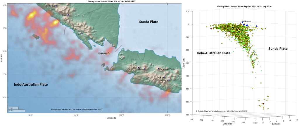
Volcanism in the area is driven by the subduction of the Indo-Australian Plate under the Sunda Plate. The Sunda Strait is seismically very active, possibly because it is accommodating the change in direction between the northern and eastern arms of the plate boundary. Krakatau, itself, lies in the bend of the Arc above the Wadati-Benioff zone.
We looked at the earthquakes in the region 8.67°S 101.00°E to 3.94°S 110.09°E for the period 1971 to 14 July 2020; this area includes the southern end of Sumatra, the Sunda Strait and the western end of Java. We downloaded the earthquake data from IRIS’s earthquake browser. The download comprised mostly earthquakes with magnitude over 4.0; smaller volcanic / tectonic earthquakes were not included in the data set.
Our plots show the subduction zone in the curve of the Sunda Volcanic Arc, with more intense seismic activity in the northern arm of the arc. The intense areas of activity in the northern arm starts in 2000, preceding the 2004 Banda Aceh earthquake, which is north of the area in our plot, and continuing for a few years afterwards.
Tambora produced one of the largest known eruptions in recorded history with a climate impacting VEI 7 and possibly the largest Holocene eruption (other contenders for a VEI 7 being Kurile Lake, 6440 BC, Mazama, 5700 BC, Kikai Caldera, 4300 BC, Cerro Blanco, 2300 BC, Thera (Santorini), 1620 BC, Taupo, 180 AD, Baekdu, 946 AD, and Samalas (Rinjani), 1257 ).
Tambora’s once proud 4,300 m stratovolcano lost around a third of its height and acquired a 1 km deep, 6 km wide caldera over the space of a few days in April 1815. Sumbawa and the surrounding islands were devastated. Climate abnormalities (cooling and severe storms) were noted round the northern hemisphere along with crop failure and famine. Tambora is accredited as the cause of the 1816 “year without a summer”. The eruption released 50 km3 of magma, 150 km3 of tephra, 80 million tonnes of sulphur dioxide and 18 mega tonnes of fluorine, along with water vapour and other aerosols.
The eruption was chronicled by local eye witnesses. However, the then lieutenant governor of Java, Sir Stamford Raffles, keen to develop trade in the area, was not so keen to broadcast it further afield to potential investors; outside the region, the eruption went largely unnoticed by the West, already distracted by the Napoleonic wars.
Geological Setting
Before the eruption, Sumbawa Island was a pleasant prosperous island, trading mung beans, corn, rice, coffee, pepper, cotton, wood and horses. Despite a wealth of natural resources, the people to farm them were in short supply so there was also a large slave trade and piracy.
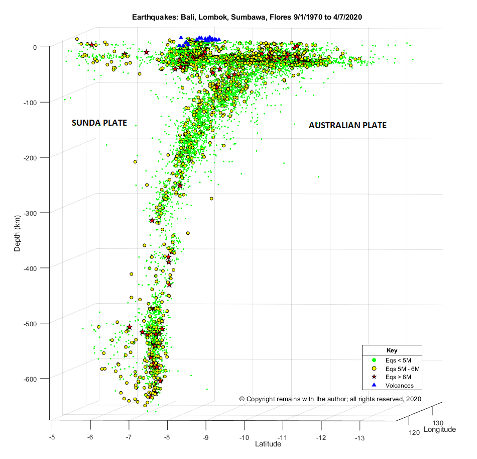
Tambora occupies the entire Sanggar Peninsula on Sumbawa Island in the Sunda Arc of the Indonesian Archipelago. Here the Australian Plate subducts beneath the Sunda Plate at a convergence rate of 7.8 cm per year. Plotting the earthquakes in the region for 1972 to date clearly shows the Wadati-Benioff zone, with volcanoes sitting around 70km above the descending plate.
Tambora is a 60 km wide stratovolcano with trachybasalt and trachyandesite lavas. She formed a caldera c.43,000 years ago which was in-filled by Pleistocene lava flows. During the Holocene her eruptions have been explosive: three eruptions in the Holocene occurred before the 1815 event, identified by radiocarbon dating, 740 AD, 3050 BC, and 3910 BC; three further smaller eruptions have been observed since the 1815 event, 1819 VEI 2, 1880 VEI 2 and 1967 VEI 0, which extruded lava domes and small lava flows on the caldera floor.
1815 eruption
Tambora had been dormant for over a thousand years; magma cooling and fractional crystallisation had been occurring along with the exsolving of high-pressure magma; over pressurisation was happening. Tambora awoke in 1812 with minor activity during the period 1812 to 1815 while magma ascended from the reservoir c.4 km below the edifice.
The 1815 eruption proper started with a short Plinian eruption on 5 April 1815 of trachyandesite, lasting two hours, producing a 33 km eruption column; the explosions were heard as far away as Sumatra and were confused with gun fire. Following this, between 5 April and 10 April, there was a relatively low level of activity.
On the evening of 10 April, a second short Plinian eruption occurred, lasting three hours, producing a 44 km eruption column. Pumice rained down on local villages for 2 hours. Volcanic winds destroyed trees and property. The eruption column collapsed as the vent was eroded. Pyroclastic density currents (PDCs) raged over the next three to four days, creating phoenix ash clouds, covering the area in ash and destroying villages, along with inhabitants. During this phase the volcano, no longer supported by magma, subsided, creating the current caldera.
Tsunamis were generated when the PDCs reached the sea. Sanggar was engulfed in a four-metre high tsunami at around 10 pm on 10 April; this tsunami reached Java a couple of hours later with a height of two metres.
Explosions were heard during the night of 10 to 11 April up to 2,600 km away. Locations within a 600km radius suffered darkness for a couple of days and a chilling of the atmosphere while sunlight was blocked.
Seven or more ignimbrite layers were deposited during the second phase of the eruption. Only 2.6 km3 of deposits remain on dry land; the heavier ejecta ended up in the sea and lighter aerosols were scattered round the globe. Pumice rafts up to 5 km wide and trees trunks littered the Flores Sea, providing a hazard for shipping for several months.
Eruptive activity continued intermittently up to August 1819.
Local and global impact of the eruption
Sumbawa was stripped of its vegetation. The death toll in Sumbawa and neighbouring Lombok was in the order of 60,000, 10,000 from the eruption itself with the remainder from disease and famine from polluted water and loss of crops and livestock. Children were sold into slavery in order for them to survive or apparently killed to avoid a slow death from starvation or worse.
The effects were also global. The volcano had lobbed 50 km3 of matter plus gases into the stratosphere. Larger particles fell back to Earth but smaller aerosols hung around for three years causing adverse weather phenomena (e.g. storms), global cooling, failed harvests, famine and disease in much of the northern hemisphere.
The global effects were exacerbated, according to ice-core sampling, by another large catastrophic eruption in 1809. The source for the 1809 has yet to be identified; the volcano and eye witnesses may not have survived the eruption. However, the 1809 and 1815 eruptions together caused a little ice age.
Can this happen again?
VEI 7 eruptions are rare. As mentioned earlier, there are currently only eight other contenders in the Holocene. That is not to say they won’t happen again in the future.
My guess is that to get another large event, not only do you need a large magma source and a build-up of pressure but also an element of edifice failure. The largest part of the Tambora eruption in terms of magma output was while the PDCs were in full swing; these occurred as or after the vent eroded. We will see in the accounts of other eruptions, there was some edifice failure.
In the meantime, Mount Tambora and her Indonesian sisters are well-monitored.
The Armchair Volcanologist
6 July 2020 (updated 23/08/2020 & 25/08/2020 to include more potential VEI 7s (the list is getting longer!)


