Good Afternoon!
The eruption at La Palma is continuing unabated, sadly with more evacuations for areas in the path of the lava.
Let’s take a moment to look at her fellow island, El Hierro. La Palma and El Hierro occupy the same N-S line at the western end of the Canary Island archipelago: La Palma to the north and El Hierro to the south. El Hierro experienced a N-S aligned fissure eruption between October 2011 and March 2012.
Background
El Hierro is a shield volcanic island which formed around 1.2 million years ago. It is made up of three volcanoes, Tiñor, El Golfo, and, later rift volcanism.
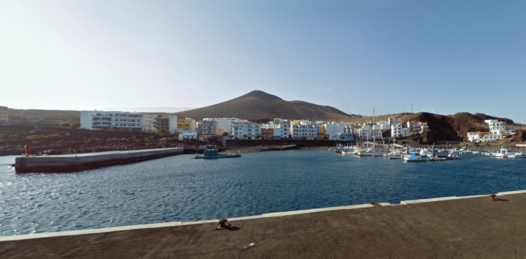
The island has a population of c. 10,000. The capital is Valverde, located near the eastern end of the island. The earliest known inhabitants were the Bimbaches, thought to be descendants of the Guanches who had migrated from Tenerife. Sadly, many of the Bimbaches were sold as slaves by the son of the first Spanish conquistador. The island was then populated by both the Spanish and Normans. Some the slaves were later returned to the island having won their freedom.
The island’s climate is influenced by the Trade Winds. Warm moist air is deposited on the northern side of the island. The climate varies from warm-summer Mediterranean climate in the centre of the island, to mild semi-arid and to a tropical mild, desert climate on the coasts.
The island, home to endemic species such as the endangered El Hierro giant lizard, has been designated as a Biosphere by UNESCO to preserve its natural and cultural diversity.
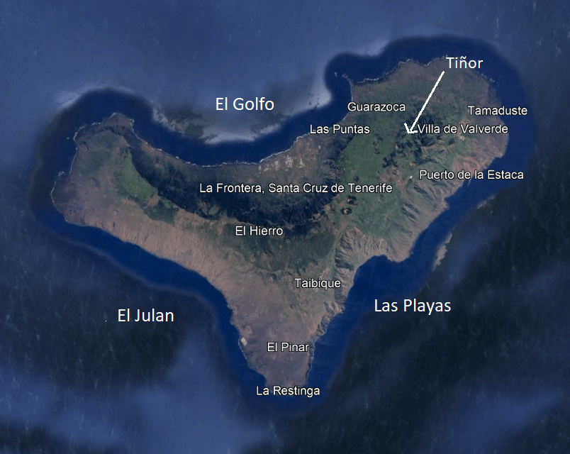
Tiñor was the first subaerial volcano to emerge, comprising primitive basalts to trachybasalts and tephrites. It is dated between 1.2 – 0.88 million years old, having developed rapidly in the Lower and Middle Pleistocene. It has three units: the lowest unit with steep sides and thin steep-dipping lava flows; a middle unit of thicker lavas; and, an uppermost unit, the Ventejis Group, with craters After the emergence of the Ventejis Group, the north western flank of Tiñor suffered a large gravitational collapse which may have taken out more than half of the Tiñor edifice.
The El Golfo volcano emerged c. 545,000 years ago, located near the current town of Frontera. This volcano has two identifiable layers: a lower unit made up of basalt Strombolian and Surtseyan pyroclasts with dykes implying the presence a triple rift system; and, the upper unit made of lava flows, overlain with trachybasalts and trachyte lava flows and block-ash deposits. The youngest lavas are the trachyte, aged at c. 176,000 years. Gravitational collapse of the southwestern flank of the volcano occurred at El Julan.
The San Andrés fault system on the north east rift developed between 545,000 -176,000 years ago. The presence of cataclasites and pseudotachylytes, rocks typically found in the early stages of volcanic collapse indicate that there was incipient gravitational collapse that did not develop further. Cataclasites are formed through faulting or fracturing in the upper crust. Pseudotachylytes may be formed by frictional melting of the wall rocks during rapid fault movement during an earthquake.
The impressive El Golfo embayment resulted from gravitational collapse of the El Golfo volcano. This may have occurred in a single or multiple events. One possible is scenarios is that an initial subaerial lateral collapse of the volcanic edifice occurred 130,000 years ago and a second one occurred 17,000 – 9,000 years ago affecting the submarine lava platform.
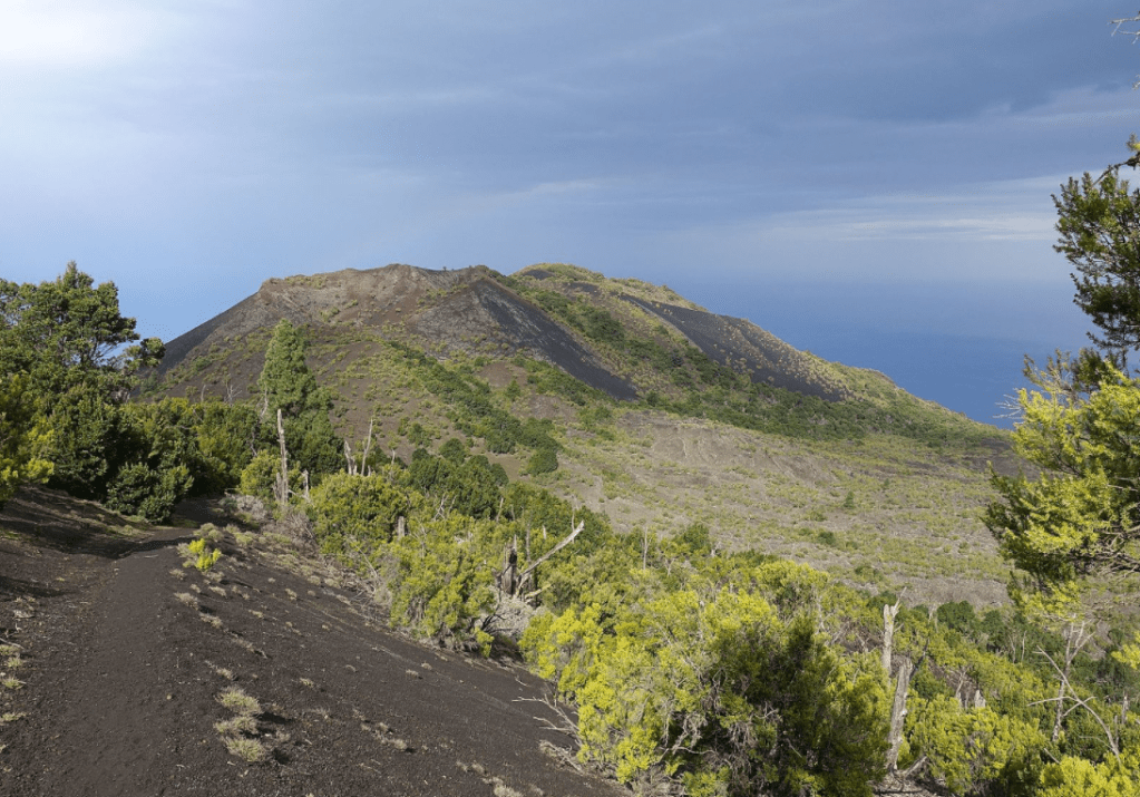
Rift volcanism, defined as when the three arms of the rift were active at the same time without a central vent, occurs along the three arms of the island, with vents occur along the ridges of the rifts. Before the 2011-2012 eruption, rift volcanism had been dated to between 134,000 years ago to 500BC. GVP lists 6 eruptions prior to the 2011-2012 eruption: 3 confirmed in 550BC, 950BC and 4790 BC; and, 3 unconfirmed in 1793, 1692 and 1677. The associated lavas are alkaline picro-basalts, basanites and tephrites.
2011 -2012 Submarine Eruption
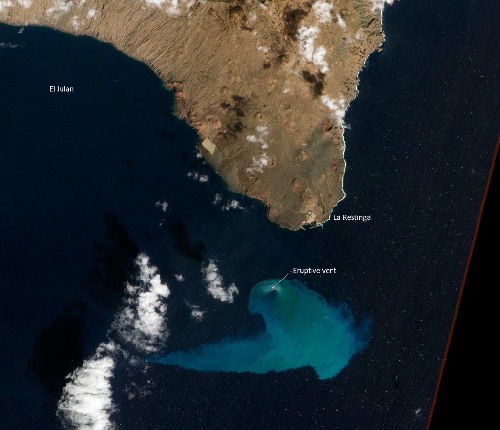
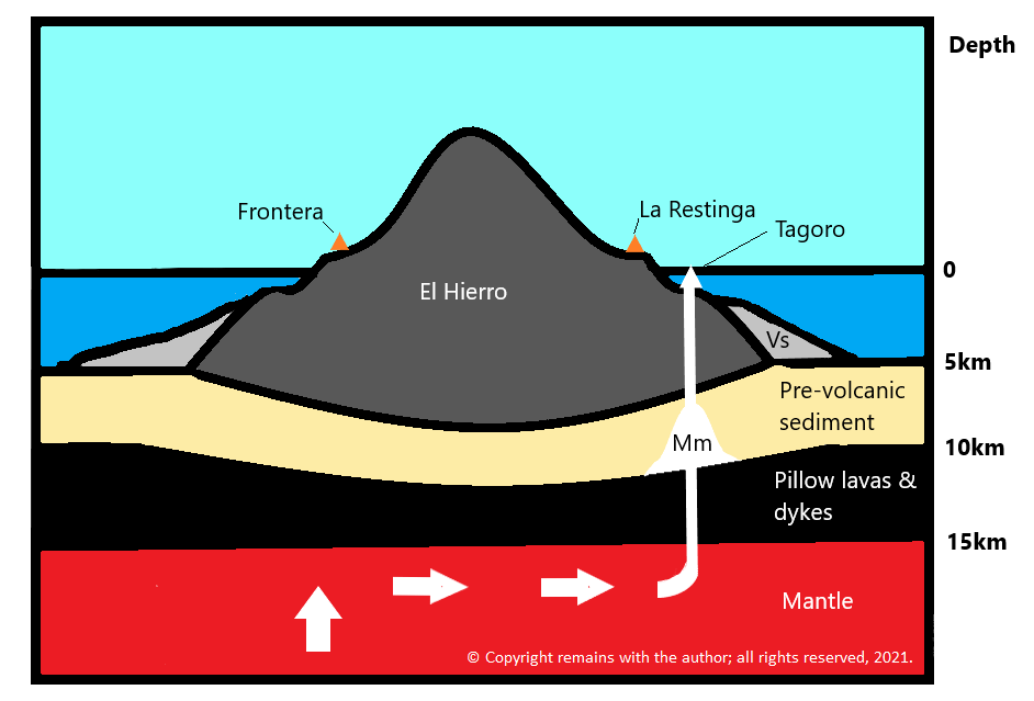
In 2011 a submarine flank eruption commenced, preceded by an intense seismic swarm. The submarine cone has been named Tagoro, from the Guanche language for meeting place or circular enclosure of stones.
Build up to the eruption
Before the eruption, El Hierro had been quiet since a seismic episode in 1793, which may or may not have been connected to an eruption. In the absence of eye-witness accounts then, it has been suggested that there was an eruption of Lomo Negro volcano, a submarine eruption or a magma intrusion.
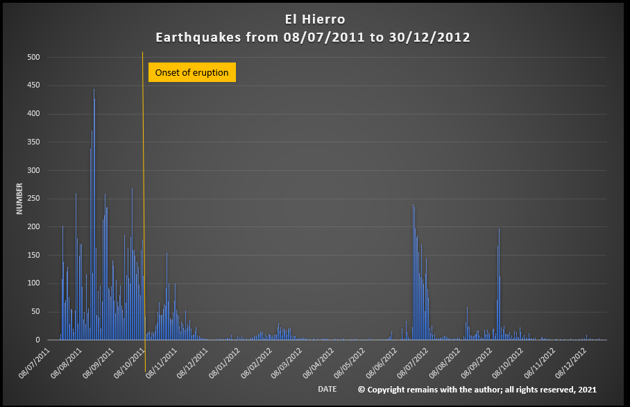
In July 2011, a seismic swarm started under El Golfo at a depth of 20-25km. Seismicity then ascended to 11±3km and headed southward across the island, after which it ascended to 3km between 8-9 October prior to the eruption on 10 October 2011. A 4.4M earthquake at a depth of 10km 1.5km south of La Restinga preceded the eruption. Magma had risen under Tanganasoga, the main volcano on El Hierro, to migrate south towards La Restinga.
Basanite fractionation and magma replenishment may have occurred during these seismic swarms while magma was being injected into the lower crust.
The eruption
The eruption occurred in phases. The lavas in the first phase were evolved basanites. The second phase was more primitive lava with 8-9 wt% MgO.
A harmonic tremor started on 10 October 2011 between 04:15 and 04:20 and is thought to indicate the start of the eruption. Magma had risen from the base of the ocean crust to the vent in c. 30 hours. Areas of discoloured, sulphurous-smelling water and dead fish were seen off the coast of La Restinga. Vigorous bubbling in the sea resembling a jacuzzi was observed above the vent, caused by gas emissions and heat from the vent; bubbling reached several metres high on occasion.
On 15 October 2011, lava bombs were observed. These comprised white to grey pumice encased in black basanite lava. Basanites are typical of the western Canary Islands. A small amount of U-depleted rhyolite was found in the lava bombs, though to have originated from differentiated trachyte incorporating quartz-rich sediment during melting when mobilised by the basanite. The boundary between old oceanic crust, continental crust and volcanic island may act as a magma trap where sediments can be assimilated. A few days later basanite lava balloons were emitted.
The second phase of the eruption started in November 2011 with seismicity at depths of 10-15km and a decrease in tremor intensity. This correlated with the eruption of more primitive lavas.
During November 2011, the eruption was confirmed as Surtseyan. Several plumes of material aligned N-S were visible from the air, confirming a fissure eruption. Tanganasoga experienced rapid inflation and released CO2. On 24th November a sulphur smell was reported in El Golfo. On 4th December 2011, vigorous phreatic bubbling (“the jacuzzi”) was observed. In December 2011, there was a temporary lull: the harmonic tremor and seismicity decreased.
The eruption picked up again in January 2012 with increased seismicity, a larger area of eruption and pumice clasts. In late February 2012, seismic activity, deformation and gas emissions decreased. The eruption was declared over in March 2012.
Tagoro’s cone was found to be 85m below sea level in April 2012. The eruption has been classified as a VEI 2.
Post eruption
Magma movements were detected from seismic swarms. In June 2012,accompanied by rapid inflation, magma moved south-westward towards El Julan-La Dehesa, northwest of the submarine vent. Earthquakes picked up again in September 2012 indicating magma movement under Tanganasoga.
The last reported seismicity was in March 2013 when another swarm occurred near the NW tip of the island, initially at 20km depth, migrating westward at a depth of 12-15km. The swarm was accompanied by inflation and CO2 emissions.
Plotting Seismicity
We have downloaded the earthquake data from IGN’s publicly available database and plotted the earthquake swarms for the period July 2011 to December 2012. The results are shown in the video below.
Only time, and a lot of work by the various scientists studying the eruption on La Palma, will tell how many similarities are shared between the two eruptions.
Armchair Volcanologist
© Copyright remains with the author; all rights reserved, 2021.
Sources & Further Reading
“Classical Geology in Europe 4: Canary Islands”, Juan Carlos Carracedo, Simon Day, Terra Publishing, 2011 (reprint).
The Smithsonian Institution’s Global Volcanism Program: Global Volcanism Program | La Palma (si.edu)
Instituto Geografíco Nacional: Instituto Geográfico Nacional (ign.es) (link for La Palma)
El Hierro: Wikipedia
