Good Morning
A major eruption occurred on the island of Hunga Tonga-Hunga Ha’Apai on 15th January 2022 at 04:14:45 am (UTC). As with Krakatau, news of the eruption arrived before the pressure wave from the blast due to modern technology (now the internet, then the telegraph). The eruption was preceded by a smaller one at the end of 2021 which ended 11th January 2022. Activity picked up again on 14th January 2022. Our thoughts are with all those affected.
2021 Eruption
Hunga Tonga-Hunga Ha’Apai has been erupting since 20th December 2021. The initial eruption produced a large plume (height unknown) and was heard up to 2,000 km away in New Zealand. Activity died down and the eruption was declared over on 11th January 2022.
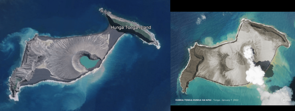
This eruption added to the land created during the 2009 and 2014/15 eruptions which links the islands of Hunga Tonga and Hunga Ha’Apai.
January 2022 Eruption
Activity resumed on 14th January 2022 with a 20 km high ash cloud. Geologists from Tonga reported large explosions and a 5 km wide ash column. Their report can be found here Tongan geologists observe stunning eruptions at Hunga | Matangitonga . At the time of writing this is the last update from the news source in relation to the eruption.
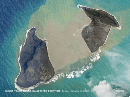
An image from @Planet taken, it is believed, two hours before the 15th January 2022 shows that the 14th January 2022 eruption had removed a lot of the subaerial land bridge between the two islands.
On 15th January 2022, a much larger eruption occurred which was heard as far away as Alaska and Canada. USGS estimate the surface wave magnitude as 5.8. The pressure wave has travelled round the globe: it was measured as 7hPa in New Zealand, 2.5hPa in Switzerland and 2hPa in the UK.
The eruption covered the surrounding islands in ash, blocking out the sun in Tongatapu, the main island in Tonga. Tonga lost its internet connection, probably due to damage to underwater cables so an assessment of the damage has not been possible. The Australian and New Zealand Governments have offered assistance, including over-flights to assess the damage; the flights are hindered by the ash cloud.
Known Impact
A large amount of material is thought to have been ejected into the stratosphere. This may cause temporary climate cooling in the region and possibly globally. New land linked the islands of Hunga Tonga and Hunga Ha’Apai was cut through during the activity on 14th January 2022; how much remains has not been confirmed at the time of writing, but it is expected that more of the subaerial edifice has been lost.
A Pacific-wide tsunami was generated which reached heights of 0.3m (Mexico), 1.3m (California), 2m (Chile), 2.5m (Vanuatu) and 1.5m (Tonga). Low lying islands such as Atata Island were submerged by the tsunami. Tsunami warning systems worked; the known fatalities are low. Although closer to the volcano where residents had only minutes to flee to higher ground, the toll is not known.
The cause of the tsunami is not known. It may have been due to one or more of the following: edifice failure allowing to sea water to reach the magma chamber causing a large explosion; a large volume of pyroclastic material dumped into the ocean; or, a submarine landslip. We will have to wait until the experts have had a chance to assess.
Background
Tonga is an archipelago of 169 flat low-lying coral limestone islands, some with volcanic bases, of which 36 are inhabited. It is home to 105,000 people, of which 70% live on Tongatapu. Tongatapu has a wealth of archaeological remains, including traces of Lapita pottery from the earliest known settlers, the Lapita. Tonga was also the seat of the Tongan Empire which emerged in 950 AD and declined after 1500 AD; it is now a kingdom with a constitutional monarchy. Hunga Tonga-Hunga Ha’Apai lies 65 km to the north of Tongatapu.
Hunga Tonga-Hunga Ha’Apai is two volcanic islands joined by a land bridge created during the 2009 eruption. Hunga Tonga is the island on the right of the images and Hunga Ha’Apai the one on the left. The islands are the subaerial manifestation of the caldera of a submarine volcano. Its lavas are andesitic. Five Holocene eruptions are recorded by GVP: 1912, 1937, 1988, 2009, and 2014; all were VEI 2, except for the VEI 0 1988 eruption. Other eruptions evidenced by rock and ash deposits, including evidence of pyroclastic flows, occurred in 1040 – 1180 CE and 1108 CE; the latter is believed to have formed the caldera and caused 1°C global cooling.
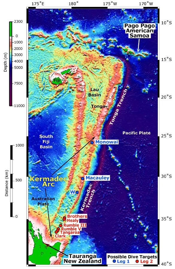
The volcano is situated 100km above the subducting Pacific Plate on the Tonga Plate in the Tonga Kermadec Volcanic Arc. The Tonga Plate is a microplate which lies between the Pacific Plate, the Niuafo’ou Plate and the Kermadec Plate.
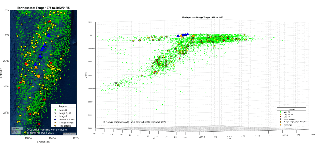
The Tonga Kermadec Volcanic Arc lies on the 3,000 km long 100 Ma old Tonga Kermadec Ridge. The ridge has two segments: the Tonga Ridge in the north and the Kermadec Ridge in the south. There are two back arc basins to the west of the ridge: the 6 Ma old Lau Basin and 2Ma old Havre Trough, that began opening at 6 Ma and 2 Ma respectively. The Tonga Kermadec Ridge moves independently of the Indo-Australian and Pacific Plates to its west and east, resp.
Armchair Volcanologist
© Copyright remains with the author; all rights reserved, 2022.
Sources:
Raw earthquake data: USGS Earthquakes | U.S. Geological Survey (usgs.gov)
