A major eruption occurred on the island of Hunga Tonga-Hunga Ha’Apai on 15th January 2022 at 04:14:45 am (UTC). As with Krakatau, news of the eruption arrived before the pressure wave from the blast due to modern technology (now the internet, then the telegraph). The eruption was preceded by a smaller one at the end of 2021 which ended 11th January 2022. Activity picked up again on 14th January 2022. Our thoughts are with all those affected.
2021 Eruption
Hunga Tonga-Hunga Ha’Apai has been erupting since 20th December 2021. The initial eruption produced a large plume (height unknown) and was heard up to 2,000 km away in New Zealand. Activity died down and the eruption was declared over on 11th January 2022.
This eruption added to the land created during the 2009 and 2014/15 eruptions which links the islands of Hunga Tonga and Hunga Ha’Apai.
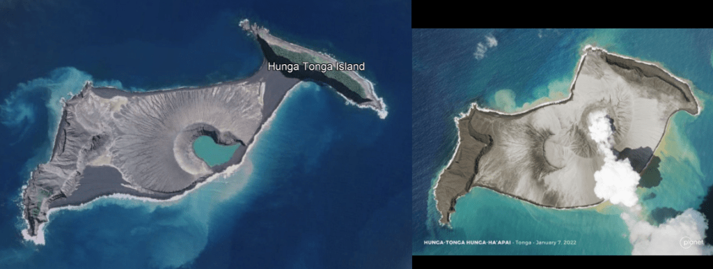
Fig 1: Hunga Tonga-Hunga Ha’Apai pre the December 2021 eruption (image from Google Earth) on the left and Hunga Tonga-Hunga Ha’Apai on January 7, 2022 on the right (image from Planet (@planet) / Twitter)
January 2022 Eruption
Activity resumed on 14th January 2022 with a 20 km high ash cloud. Geologists from Tonga reported large explosions and a 5 km wide ash column. Their report can be found here Tongan geologists observe stunning eruptions at Hunga | Matangitonga . At the time of writing this is the last update from the news source in relation to the eruption.
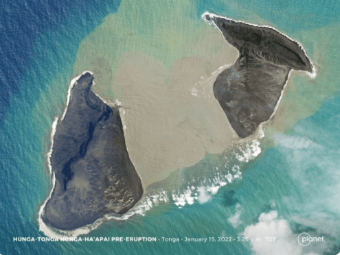
An image from @Planet taken, it is believed, two hours before the 15th January 2022 shows that the 14th January 2022 eruption had removed a lot of the subaerial land bridge between the two islands.
On 15th January 2022, a much larger eruption occurred which was heard as far away as Alaska and Canada. USGS estimate the surface wave magnitude as 5.8. The pressure wave has travelled round the globe: it was measured as 7hPa in New Zealand, 2.5hPa in Switzerland and 2hPa in the UK.
The eruption covered the surrounding islands in ash, blocking out the sun in Tongatapu, the main island in Tonga. Tonga lost its internet connection, probably due to damage to underwater cables so an assessment of the damage has not been possible. The Australian and New Zealand Governments have offered assistance, including over-flights to assess the damage; the flights are hindered by the ash cloud.
Known Impact
A large amount of material is thought to have been ejected into the stratosphere. This may cause temporary climate cooling in the region and possibly globally. New land linked the islands of Hunga Tonga and Hunga Ha’Apai was cut through during the activity on 14th January 2022; how much remains has not been confirmed at the time of writing, but it is expected that more of the subaerial edifice has been lost.
A Pacific-wide tsunami was generated which reached heights of 0.3m (Mexico), 1.3m (California), 2m (Chile), 2.5m (Vanuatu) and 1.5m (Tonga). Low lying islands such as Atata Island were submerged by the tsunami. Tsunami warning systems worked; the known fatalities are low. Although closer to the volcano where residents had only minutes to flee to higher ground, the toll is not known.
The cause of the tsunami is not known. It may have been due to one or more of the following: edifice failure allowing to sea water to reach the magma chamber causing a large explosion; a large volume of pyroclastic material dumped into the ocean; or, a submarine landslip. We will have to wait until the experts have had a chance to assess.
Background
Tonga is an archipelago of 169 flat low-lying coral limestone islands, some with volcanic bases, of which 36 are inhabited. It is home to 105,000 people, of which 70% live on Tongatapu. Tongatapu has a wealth of archaeological remains, including traces of Lapita pottery from the earliest known settlers, the Lapita. Tonga was also the seat of the Tongan Empire which emerged in 950 AD and declined after 1500 AD; it is now a kingdom with a constitutional monarchy. Hunga Tonga-Hunga Ha’Apai lies 65 km to the north of Tongatapu.
Hunga Tonga-Hunga Ha’Apai is two volcanic islands joined by a land bridge created during the 2009 eruption. Hunga Tonga is the island on the right of the images and Hunga Ha’Apai the one on the left. The islands are the subaerial manifestation of the caldera of a submarine volcano. Its lavas are andesitic. Five Holocene eruptions are recorded by GVP: 1912, 1937, 1988, 2009, and 2014; all were VEI 2, except for the VEI 0 1988 eruption. Other eruptions evidenced by rock and ash deposits, including evidence of pyroclastic flows, occurred in 1040 – 1180 CE and 1108 CE; the latter is believed to have formed the caldera and caused 1°C global cooling.
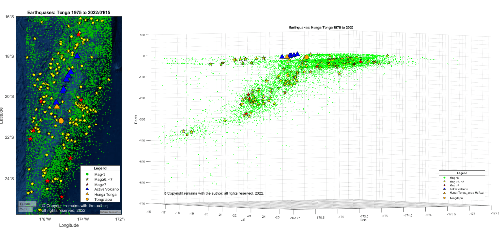
The volcano is situated 100km above the subducting Pacific Plate on the Tonga Plate in the Tonga Kermadec Volcanic Arc. The Tonga Plate is a microplate which lies between the Pacific Plate, the Niuafo’ou Plate and the Kermadec Plate.
The Tonga Kermadec Volcanic Arc lies on the 3,000 km long 100 Ma old Tonga Kermadec Ridge. The ridge has two segments: the Tonga Ridge in the north and the Kermadec Ridge in the south. There are two back arc basins to the west of the ridge: the 6 Ma old Lau Basin and 2Ma old Havre Trough, that began opening at 6 Ma and 2 Ma respectively. The Tonga Kermadec Ridge moves independently of the Indo-Australian and Pacific Plates to its west and east, resp.
Krakatau’s VEI 6 eruption of 1883 is the next in our series of famous eruptions. We have also included a summary of birth of Anak Krakatau from the caldera, and the December 2018 cone collapse and resulting tsunami.
The 1883 eruption is not only famous for the catastrophic destruction of Krakatau Island, pyroclastic flows, global cooling, devastating tsunamis and a death toll of between 36,164 to 120,000 people, but it is also the first major eruption to have been reported globally by telegraph. A typo in the telegraph led to the west calling the volcano Krakatoa.
The 2018 eruption, cone collapse and tsunami are well-documented by various sources. Our go-to resource here was primarily GVP.
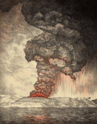
Fig 1: Lithograph: Parker & Coward, Britain. 1888. Public Domain
Geological Setting
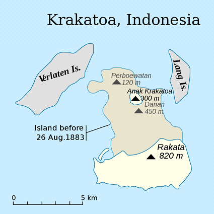
Katakatau lies to the west of the Sunda Strait between Sumatra and Java. It is the site of a much larger 7 km wide caldera which may have been formed during eruptions in 416 AD or 535 AD. The edges of the caldera are marked by Verlaten and Lang Islands.
Before the 1883 eruption, Krakatau was a 9 km long verdant, wooded island formed from three volcanoes, Rakata, Danan and Perbuwatan in the caldera. Another small island in the group was Polish Hat. The islands were uninhabited but used by local fishermen, woodcutters and the Dutch and British navies.
Fig 2: Map by ChrisDHDR showing Krakatau Island before the eruption and the site of Anak Krakatau, Public Domain
Eruptive History
GVP records 56 known Holocene eruptive periods for Krakatau, of which only 10 precede the 1883 eruption. The evidence for the 10 is historical observations from 250 AD to 1684, so perhaps earlier activity has been lost under the debris from more recent events. Activity after 1883 relates to building of Anak Krakatau.
The 535 AD eruption of Krakatau may have caused the volcanic aerosol veil that dimmed the Sun (filtered out sunlight) for eighteen months, causing crop failures, cooling and hiding Canopus, a bright star used by Chinese astronomers to mark the seasons – more likely if the eruption was a large caldera forming event. The other contender (preferred by some) is the 408 AD – 536 AD Tierra Blanca Joven eruption of Ilopango, El Salvador. On the other hand, why exclude one? Both may have contributed in some way.
Krakatau’s lavas are typical of a subduction zone: andesite, basaltic andesite, dacite, trachyte and trachydacite; and, also basalt and picro basalt. The last mentioned indicates that there may be more rapid magma ascent through extensional faulting in the area.
The 1883 Eruption: 100 Days of Activity
The Intro
The only known precursors to the 1883 eruptions are a large earthquake on 1 September 1880 followed by a period of increasing seismicity. Unfortunately, the area is seismically very active, being near the convergent margin between the Sunda Plate and the descending Indo-Australian Plate so, without modern instrumentation, there was insufficient information to interpret escalating events.
On the 20 May 1883 eruptive activity started at the Perbuwatan crater with series of loud explosions audible 150 km away. Light ashfall covered the area and a column of steam was visible. Activity continued for a few days then calmed down enough for a party to charter a boat to the island on 27 May 1883; they were the only witnesses to the Perbuwatan crater, then about 1 km in diameter, 50 m deep, with a small pit generating a steam column and small explosions every 5 to 10 minutes. By the end of June 1883, the summit of Perbuwatan had been destroyed and a second eruption column was visible at the centre of the island.
Captain Ferzenaar, a surveyor for the Dutch government, collecting ash samples on 11 August 1883, found a thick covering of tephra, all vegetation stripped bar a few tree trunks; three active eruption columns (one at Perbuwatan and the other two near the centre of the island); and, at least eleven other sites with some activity. However, upwind of the eruption, he was unable to see more beyond the steam and ash.
The Cataclysmic Eruption
The main event occurred over 26 and 27 August 1883. There were very few survivors so it took while for Dutch investigators, led by Rogier D.M. Verbeek, a mining engineer and geologist, and British investigators from the Royal Society to reconstruct the events. Their information came from various sources, including ships caught in the Sunda Strait, pressure gauges at the Batavia gasworks on Java, Dutch officials living in Batavia and Buitenzorg, and requests for information from the Royal Society for data further afield, including one printed in The Times.
Three days before 26August, there had been a marked increase in activity on the island. By 13: 00 on 26 August explosions were loud enough to be heard 150 km away. By 14:00 a 25 km high black eruption column was visible. By 17:00 activity was audible throughout Java and pumice was raining down on vessels in the Strait. By 19:00 a Plinian eruption column with intense volcanic lightening was witnessed. Several ships were among those caught up in the eruption, one of which, the Charles Bal, trapped by poor visibility had to sail within sight of the volcano to keep its bearings amid hot ash fall, volcanic gases, lightening and St Elmo’s Fires (static electricity which lit up the mastheads).
The eruption escalated on 27 August with large explosions at 05:30, 06:44, 10:02 and 10:52 in the morning (local time). The noise from these woke people 3,224 km away in Australia; and, further away at a distance of 4,811 km, it was confused with gunfire. Atmospheric pressure changes were detected globally. These explosions generated a 40 km high Plinian eruption column that cut out the sun for up to two days in the vicinity; further away in Batavia, full loss of light lasted for just over an hour and a half. There is some debate on what caused the large explosions, including the possibility of sea water reaching either the magma chamber or ascending hot magma.
Pyroclastic density currents (PDCs) made it to southern Sumatra, killing 2,000 people. The inhabited islands of Sebesi and Sebuku between Krakatau and Sumatra were devastated, with no survivors. Hot ash from the PDCs burned people as far away as Kalimbang, Sumatra.
The tsunamis caused the most of the remaining fatalities (estimates of the total number of fatalities vary from c. 36,000 to 120,000). A series of tsunamis devasted the shores of the Sunda Strait; waves reached a height of 25m on the coast of Sumatra and 40m on Java. The town of Anjer was washed away. The largest tsunami wave at Batavia was detected at 12:36 on 27 August. The waves reached as far as Auckland, New Zealand. The tsunamis may have been caused by displacement of large amounts of seawater from the rapid deposit of ash in the caldera form discrete explosions, collapse of the eruption columns or edifice collapse. As you will see later, the edifice failure of Anak Krakatau in December 2018 caused a catastrophic tsunami.
The eruption calmed down after the four large explosions, with some outbreaks of minor activity, to be quiet after 28 August 1883.
The Immediate Aftermath
Two thirds of Krakatau Island had disappeared – either blown apart by the eruption or sunk as part of the creation of a 300m deep caldera; only the southern section of Rakata remained. Pumice and a small rock were all that remained of the northern part of the island.
20 km3 of dacite pyroclastic material had been erupted as tephra, pyroclastic density currents and the rest deposited into the sea and on surrounding islands. Deposits enlarged Verlaten and Lang Islands and two new islands were formed: Steers and Calmeyer. Polish Hat, however, had disappeared. Steers and Calmeyer were later eroded by sea water.
The 40 km high eruption column had reached into the stratosphere, where ash was spread round the globe, initially in the tropics but then migrating northwards and southwards, lingering for a couple of weeks. Aerosols filtered sunlight resulting in vivid sunsets; the sun is reported as appearing as green or blue, depending on its angle in the sky. Filtering of the sunlight caused global cooling probably in the order of 0.34°C in 1884.
The Birth, Collapse and Regrowth of Anak Krakatau
Krakatau has remained active with over 40 eruptive episodes since the 1883 eruption. Anak Krakatau (Child of Krakatau) emerged in 1927 from the caldera and had reached a height of 338m by 2018, only to lose a large part of the new cone in December 2018 when a relatively small eruptive episode (VEI 3), which started in June 2018, caused edifice failure. The edifice collapse was preceded by an eruption at 21:03. Øystein Lund Andersen, a photographer, recorded that by 21:05 a dark plume obscured the volcano and earlier incandescence. At 21:27 the first tsunami wave hit the shore, travelling 15m inland; at 21:31 a second much larger wave followed.
Two thirds of Anak Krakatau had been destroyed. The tsunamis killed 437 people, injured 31,943, displaced a further 16,198 and damaged 186 miles of the shore line in Sumatra and Java. Ash and gases cleared Kecil Island and a large part of Anak Krakatau, itself, of vegetation.
This edifice collapse had been predicted. Volcanologists from the University of Oregon had noted in January 2012 that the cone, formed on a steep slope of the 1883 caldera, was vulnerable to edifice collapse, especially on the western side.
The eruptive activity has continued, initially underwater, producing Surtseyan activity. Cone rebuilding is continuing with both submarine and subaerial activity. Recently, there was a small magmatic eruption in April 2020, producing two ash columns that reached 14 km and 11 km height and lava fountains.
Recent Seismicity
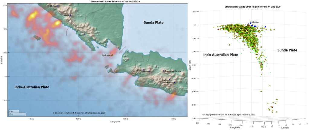
Volcanism in the area is driven by the subduction of the Indo-Australian Plate under the Sunda Plate. The Sunda Strait is seismically very active, possibly because it is accommodating the change in direction between the northern and eastern arms of the plate boundary. Krakatau, itself, lies in the bend of the Arc above the Wadati-Benioff zone.
We looked at the earthquakes in the region 8.67°S 101.00°E to 3.94°S 110.09°E for the period 1971 to 14 July 2020; this area includes the southern end of Sumatra, the Sunda Strait and the western end of Java. We downloaded the earthquake data from IRIS’s earthquake browser. The download comprised mostly earthquakes with magnitude over 4.0; smaller volcanic / tectonic earthquakes were not included in the data set.
Our plots show the subduction zone in the curve of the Sunda Volcanic Arc, with more intense seismic activity in the northern arm of the arc. The intense areas of activity in the northern arm starts in 2000, preceding the 2004 Banda Aceh earthquake, which is north of the area in our plot, and continuing for a few years afterwards.
