Part 1: Tectonic Setting and History
Good Afternoon!
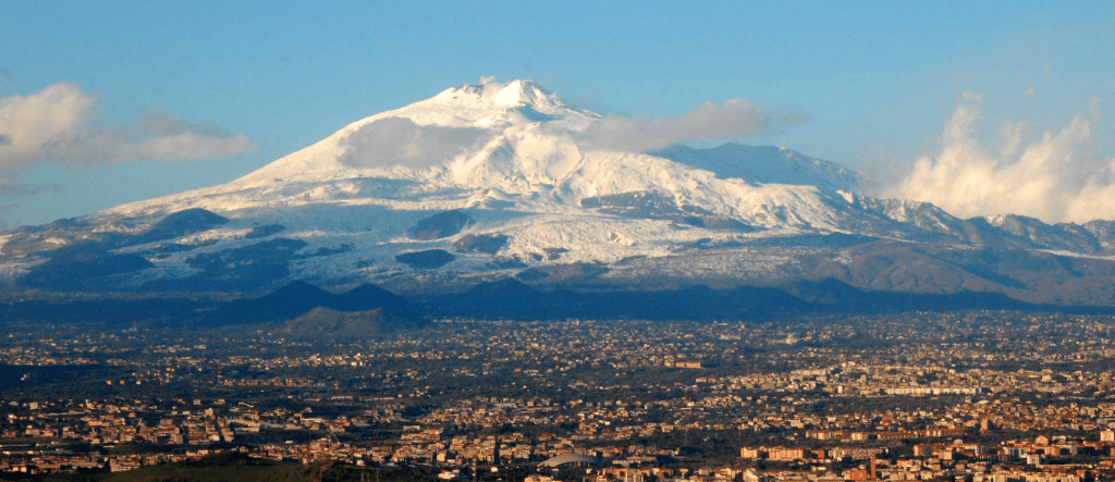
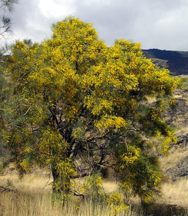
Today we are looking at Mount Etna, Europe’s largest and most active volcano, sited on the eastern side of Sicily. Sicily has been at the heart of many Mediterranean trading routes. As a result, the volcano has been widely studied. Etna has been designated a Decade Volcano by the UN. She is home to indigenous species, Etna Broom, which thrives on its lower slopes. In 2013, she was designated a UNESCO World Heritage Site.
Apart from the widely reported recent activity, she caught our eye because of the interesting tectonic setting between the African Plate, Eurasian Plate, Adriatic Plate and additional micro-plates. The area has some of the deepest subduction in the Mediterranean region. We start with her tectonic setting.
Mount Etna is a c.3,320m high complex volcano with four summit craters: the North East, Voragine, Bocca Nuova and the South East Craters and many cinder cones. The volcano is made up of an old shield volcano, topped by stratovolcanoes, Ellittico and Mongibello. It is truncated by small nested calderas.
The volcano has erupted basalts, viscous granitic lava, trachyte and again basalt. The last is rich in iron with microscopic gold particles. The basalt is used for building and sculpture. Until health and safety concerns banned it, the fluid lava was collected to be made into souvenirs for tourists.
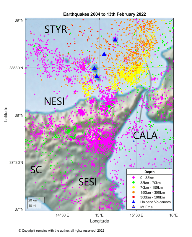
The source for Etna’s lavas is not clear. You will see from our earthquake plots below that there is little evidence of subduction beneath Etna, herself, although there is clear evidence of subduction beneath the neighbouring Aeolian Arc. Various theories have been proposed: rifting; a hot spot; and, the intersection of breaks in the crust associated with the subduction of the African Plate under the Eurasian Plate, providing a channel for magma.
Tectonic Setting
The collision of the Eurasian and African Plate has a complex history. In the vicinity of Sicily, the Tyrrhenian and Ionian Seas opened, the Aeolian – Calabrian Arc suffered subduction, bending and compression and the edge of the Eurasian Plate was thrust over the edge of the African Plate. The Adriatic Plate broke off and the Ionian Plate was subducted under the Tyrrhenian Sea.
Sicily
The main tectonic features of Sicily are the crystalline units of the Calabrian arc; the Neogene Maghrebian fold and thrust belt created during the opening of the Tyrrhenian Basin; the Catania – Gela foredeep; and the Hyblean Plateau.
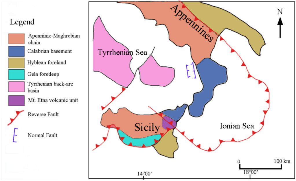
The Calabrian Arc unit is located in the north eastern part of Sicily. It is the tectonic unit that connects the Apennines with the North African Maghrebide. The Arc migrated to the south east, driven by the subduction of the Ionian slab east of Sicily. In the early Miocene, Calabria was attached to Sardinia. Trench roll back to the east and extension in the middle Miocene, caused Calabria to break off from Sardinia. By the early Pliocene, back arc volcanism relating to subduction of the Ionian slab had created new crust in the Tyrrhenian Sea. From the Pleistocene, the eastern portion of the Arc formed the Apennine mountains in Italy, while the Calabrian block had migrated to Sicily. The migration is ongoing. Palaeozoic igneous and metamorphic basement rocks are exposed at this part of the island. Triassic late Cretaceous carbonate is overlain by Paleogene – Middle Miocene turbidites, Middle Miocene to – Messinian rift deposits, Messinian evaporites and early Pliocene chalk.
The Maghrebian fold and thrust belt, part of a subduction regime, comprises frontal accretion and detached nappes of Mesozoic carbonate, which has been folded in to a syncline, underlying the anticline of the Caltanissetta region.
The Catania – Gela foredeep extends from the northern margin of the Hyblean Plateau to the offshore Gela basin of southwestern Sicily. It was formed due to bending of the carbonate platform caused by loading at the front of the Gela nappe. In the late Miocene – Pleistocene sediments were deposited, including limestones, evaporites and sandy clays.
The Hyblean Plateau is on the Nubian Plate. In the early Miocene, regional uplift caused by thrusting and volcanism resulting in the emergence of a carbonate platform in the eastern Hyblean Plateau. In the late Miocene, sea level fall and uplift caused the deposition of evaporites in the Mediterranean basin. This was followed by subsidence in the foreland and deposition of sediments. In the late Miocene – early Pleistocene, basaltic volcanic activity occurred; alkaline basalts were erupted during the late Miocene. In the late Pliocene, large volumes of tholeiitic basalt was erupted and the foredeep north of the Hyblean foreland collapsed.
Mastrolembo et al(1) found evidence for independent lithospheric blocks by studying GPS velocities relative to the Eurasian and Nubian Plates. The Sicilian domain rotates clockwise with respect to Eurasia and is fragmented into three distinct blocks: the south eastern, the central and the north eastern Sicily blocks, which move independently from the African Plate.
Deep faults transect the island. Currently, the Tyrrhenian side of Sicily is being compressed and the Ionian side extended. Mount Etna, itself, is located near to the junction of three major lithospheric faults which may reach the mantle: the east to west Mt Kumeta -Alcantara fault; the north -northeast to south-southwest Messina – Giardini fault which delimits the north coast of Etna; and, the Aeolian-Maltese fault which extends from Vulcano to Malta.
Mount Etna’s History
Mount Etna is a complicated volcanic system; she is thought to have evolved in four stages: 1) tholeiitic basalt; 2) Timpe shield-building; 3) Valle del Bove Central Volcanoes; and 4) Stratovolcanoes.
Tholeiitic Basalt Stage
Earliest activity at Etna has been identified as being the sporadic eruption of tholeiitic pillow lavas from fissures more than 500,000 years ago in the submarine environment of the Gela-Catania foredeep basin at Aci Castello. 300,000 years ago, Na affinity lavas were erupted in fissure eruptions on the alluvial plain of the Simento River, forming a lava plateau.
Timpe Shield Building Stage
220,000 years ago, extension tectonics of the NNW-trending Timpe fault system drove activity. Sub alkaline – Na alkaline were lavas erupted in fissures along the Ionian coast built a 22 km NNW -SSE aligned shield volcano. Volcanic activity also occurred to the south west and south east of the location of the now current edifice. 129,000 to 126,000 years ago, activity shifted to a location at the central portion of the location of the current volcano.
A 15km horseshoe depression in the east flank of the edifice was created during this period. The edifice rested on basement rocks of Miocene argillaceous turbidites in the north and west, but on Pleistocene clay rich marine sediments to the south and the east. The clays were unable to support the weight of the edifice, resulting in slippage and subsidence to the east.
Valle Del Bove Central Volcanoes Stage
During this period magma ascent through the crust became more localised, allowing the building stratovolcanoes. Several monogenetic volcanoes are visible in the Valle del Bove scars. Na-alkaline lavas were erupted.
121,000 years ago, effusive eruptions occurred on the southern edge of the volcano in the N – S aligned Tarderia and Rocce volcanoes in the Valle Del Bove area. Activity at Tarderia and Rocce ended between 106,000 and 102,000 years ago, respectively.
Trifoglietto volcano was also active at this time. While the onset of activity at Trifoglietto is not known (there are no rocks outcropping to date), activity is believed to have ended c. 99,000 years ago with explosive benmoreitic Plinian eruptions.
Activity then shifted to Monte Cerasa, Giannicola, Salifizio and Cuvigghiuni volcanoes. Monte Cerasa volcano is a large composite stratocone in the central part of the present Valle del Bove with explosive eruptions and pyroclastic flows which transitioned to more effusive eruptions. Activity ceased here 93 ka ago. Giannicola volcano is a 300 m neck intruded in the northern flank of Trifoglietto volcano about 85 ka ago followed by alternating pyroclastic deposits and lava flows. The main vent Salifizio volcano was located 1 km east of Trifoglietto. She produced effusive lavas that covered the eastern sides of Trifoglietto and Monte Cerasa. Cuvigghiuni erupted intrusive bodies into the western side of Trifloglietto, followed by lava flows , spatter deposits and pyroclastic flows between c. 80,000 and 65,0000 years ago. The final stage of her activity was effusive lava flows.
The Valle Del Bove, itself, was created during this period. Subsidence of the Trifloglietto volcano to the east led to reduction in magma pressure, successive violent hydro-magmatic eruptions and debris avalanche flows which carved out the Valle.
Stratovolcanoes Stage
In the fourth phase of growth , c. 60,000 years ago, Etna’s magmatic plumbing system had stabilised at its current position. Two overlapping stratovolcanoes were formed, which form the current upper edfice: Ellittico between 60,000 and 15,000 years ago and Mongibello from 15,000 years ago to present. Ellittico erupted trachybasalt, followed by mugearites, benmoreites and trachytes, reaching a height of 3,700m before 4 caldera-forming Plinian eruptions signalled the end of activity at Ellittico.
From 15,000 years ago to present, activity at Mongibello has been a mix of lava flows and a few Plinian to sub-Plinian eruptions of basaltic / picritic magma. Silicic eruptions occurred in 8,460, 7100, 6100, 5000 and 4280 years ago. In 122BC a Plinian eruption formed the Cratere del Piano, the summit caldera. Other eruptions were basaltic, filling the caldera and building the cone.
GVP lists 241 Holocene eruptions for Etna, of which 196 have been confirmed. These include 2 VEI 5, 1 VEI 4, 26 VEI 3, and 167 VEI 2 or less. The VEI 5’s are the 122BC Cratere del Piano and another in 1500 BC.
Subsidence is continuing on the eastern flanks of the edifice, creating a series of rift faults and fault scarps.
Recent Seismicity
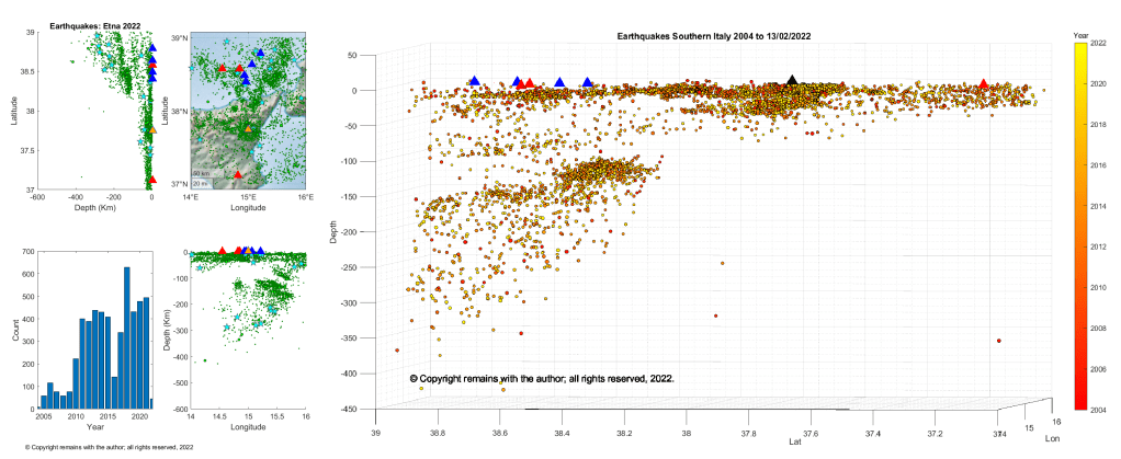
We have plotted earthquakes downloaded from EMSC for the period 1st October 2004 to 13th February 2022 for the area 37°N, 14°E to 39°N, 16°E.
There is little evidence of a Wadati-Benioff zone under Etna, although the area is seismically active. Our plots clearly show the subducted Ionian slab under the South Tyrrhenian Sea.
An Armchair Volcanologist
© Copyright remains with the author; all rights reserved, 2022
Sources & Further Reading
There is no shortage of reading matter about Mount Etna. A quick internet search will probably fund you what you want. Here are the resources we used:
- 1. Brunella Mastrolembo Ventura, Enrico Serpelloni, Andrea Argnani, Alessandro Bonforte, Roland Bürgmann, Marco Anzidei, Paolo Baldi, Giuseppe Pulisi, “Fast geodetic strain-rates in eastern Sicily (southern Italy): New insights into block tectonics and seismic potential in the area of the great 1693 earthquake – ScienceDirect”, Earth and Planetary Science Letters 404 (20 14) 77-88.
- Stefano Branca, Mauro Coltelli, Emanuela De Beni & Jan Wijbrans , Geological evolution of Mount Etna volcano (Italy) from earliest products until the first central volcanism (between 500 and 100 ka ago) inferred from geochronological and stratigraphic data | SpringerLink
- Alwyn Scarth, Jean-Claude Tanguy, “Volcanoes of Europe”, Terra Publishing, 2001
- Geology of Sicily – Wikipedia
- Mount Etna – Wikipedia
- Raw earthquake data: https://www.emsc-csem.org/

.svg)