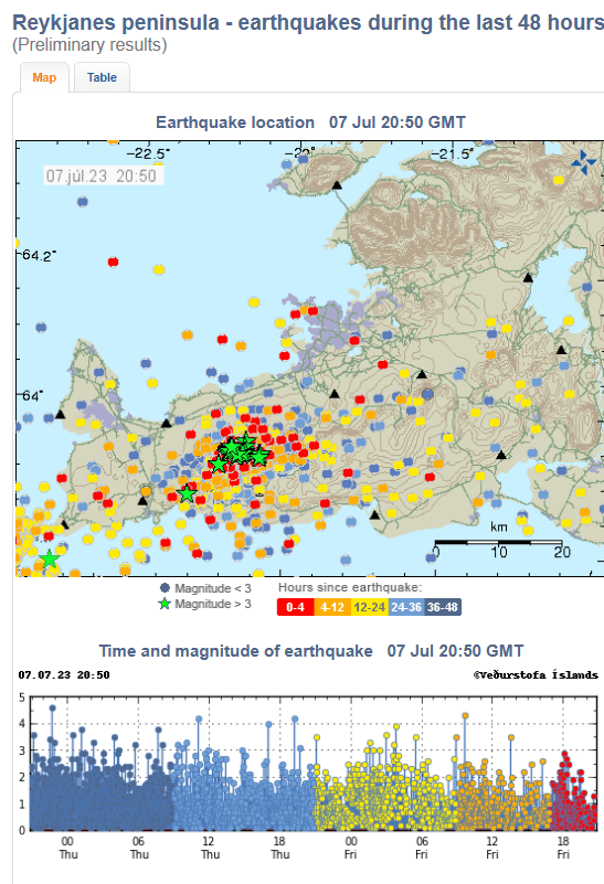
The earthquake swarm which started on 4th July 2023 is continuing vigorously as we write, with 7,000 earthquakes detected. InSAR has confirmed that there is a dike intrusion between Fagradalsfjall and Kelir. IMO have said that magma is likely to have reached a depth of around 1 km by 6th July, causing a fracture of a 2.8 km length between Fagradalsfjall and Keilir, centred a little north of Litli-Hrútur. The expectation is that, if an eruption occurs, it will be in hours or days. The eruption may be short but bigger in its initial stages than the 2021 and 2022 eruptions. The alert level remains at orange.
A smaller swarm is also ongoing southwest of the peninsula on the Reykjanes ridge, near the island of Eldey. This may be due to crustal accommodation of the magma intrusion between Fagradalsfjall and Kelir and/or it may be independent activity. The alert level has been raised to yellow. We will look at this in later posts.
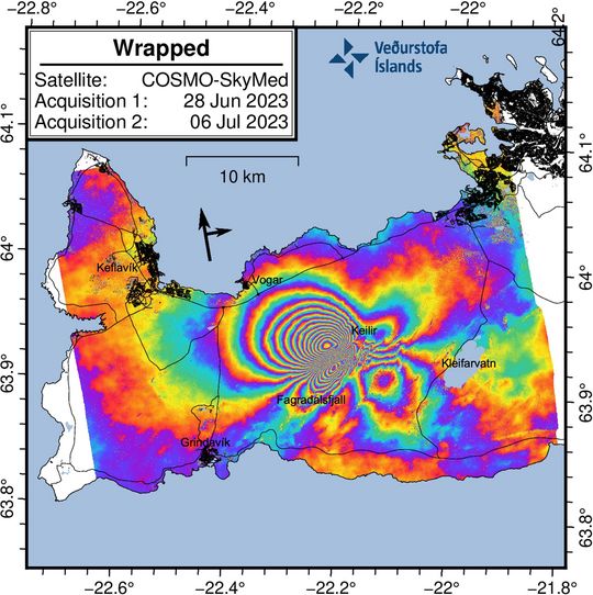
From IMO, Earthquake activity in Fagradalsfjall area | News | Icelandic Meteorological office (vedur.is), “COSMO-SkyMed interferogram covering the period 28 June to 6 July 2023.
The wrapped image (Fig 2) clearly shows a series of multicolored fringes centered bewtween Fagradalsfjall and Keilir. These fringes show ground deformation caused by the new dike intrusion which commenced on 4 July 2023. The maximum observed deformation related to the dike intrusion is up to 18 cm in the satellite‘s line-of-sight (los) in the NW direction.
Although the deformation signal extends over a large area of the western Reykjanes Peninsula, this does not mean there is magma beneath this entire region. The magma intrusion is situated bewteen Fagradalsfjall and Keilir. There is no indication of additional magma movements outside this area.
Several small lineaments are also visible in the interferogram which cut across the fringes. These represent fault movements/earthquakes that were triggered during the dike propagation.”
We have updated our earthquake plots to this morning, 7th July 2023 09:37 using the published earthquakes from https://skjalftalisa.vedur.is .
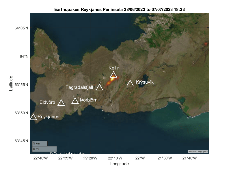
Fig 5: Geodensity plot by the author of earthquakes occurring in the current swarm on the Reykjanes Peninsula. © Copyright remains with the author; all rights reserved, 2023.
Time will tell whether and where lava emerges with the current swarm.
Our thanks go again to the Icelandic Met Office, IMO, https://www.vedur.is/, for the raw earthquake data. For updates, please visit IMO.
Armchair Volcanologist
© Copyright remains with the author; all rights reserved, 2023
