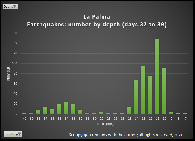
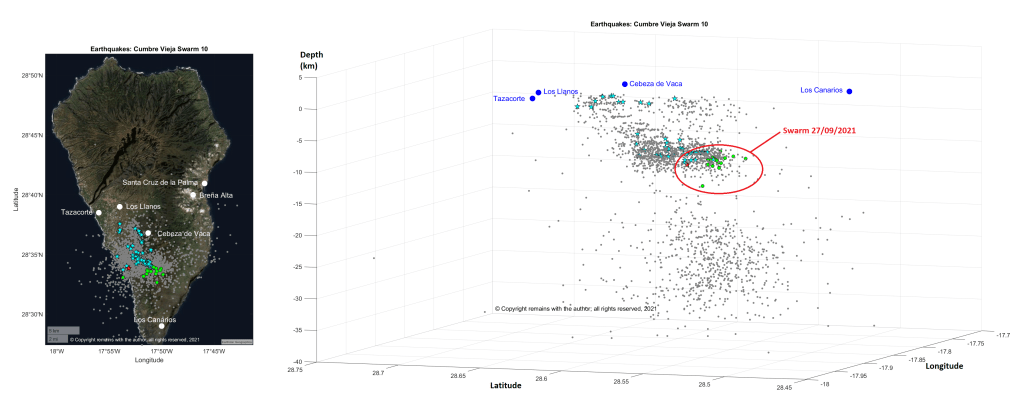
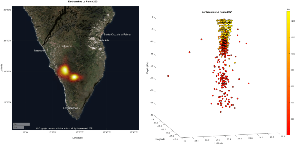
We have updated our earthquake plots to 19.10.2021 8:41:10. Since our previous update there has been more seismic activity, mainly between depths of 9-15km and 32- 42km. The former is consistent with the initial and subsequent stages of the swarm; the latter is consistent with the deeper earthquakes which started on day 21 (1.10.2021).
We’ve Googled around to see what’s likely to be going on at these depths. The 1585, 1949 and 1971 eruptions may shed some light on this. Researchers have found that the erupted lavas are formed by fractional crystallisation and stored in the upper mantle; during ascent, these lavas stall in the lower crust or near the Moho; there are no long-lived shallow magma reservoirs.
Fractional crystallisation is an indicator of the depths at which magma stalls in reservoirs. Earthquakes tend to occur around magma reservoirs or during the ascent of magma in response to the stresses on rock that changes in magma produce. Hence our interest in them.
The 1585 eruption produced 0.03km3 of lava, which was composed of basanites, tephrites, tephriphonolites and phonolite. The eruption is famous for the extrusion of phonolitic spines, named “Devil’s horns” by eye-witnesses, at the start of the eruption. Examination of the 1585 lavas indicate that the more evolved lavas were the result of fractional crystallisation. Magma differentiated at three levels: in the deeper mantle, c.20km depth, basanite evolved to tephrite 1550 to 1750 years, collecting in more than one reservoir, before the eruption; basanite also stagnated at the base of the crust, c.14km depth, to differentiate to tephrite; and, differentiation also occurred in the edifice. Further evolution of to tephriphonolite / phonolite may have occurred in the lower crust and upper crust. The basanite erupted may have originated from a different batch of magma than the erupted tephrite. 14km is the depth of the Moho under La Palma.
The 1949 eruption started on 24 June 1949 and ended on 30 July 1949. It had been preceded by weak seismic activity from 1936. Seismic activity picked up in February 1949, being felt mostly at the southern tip of the island and accompanied by ground cracking. Stronger seismicity and ground cracking immediately preceded the opening of the first vent. The primary melt was sourced at depths between 80-100km. Fractional crystallisation occurred at 20 to 26km with some possibly at 26-36km. Magma was stored temporarily in the crust before eruption. Magma mixing occurred in the mantle three months prior to eruption, causing a dike to propagate southwards. A 3km long fissure eruption started with the Duraznero crater emitting tephrite for 14 days. This was followed by the Llano Blanco crater opening to erupt tephrite for three days, followed by basanite for three days. The Hoyo Negra crater opened 4 days later to erupt basanite, tephrite and phonotephrite, during which the Llano Blanco crater continued to erupt basanite. The Duraznero crater then erupted basanite. The eruption started on 24 June 1949 and ended on 30 July 1949. The primary melt was sourced at depths between 80-100km. Fractional crystallisation occurred at 15 to 26km with some possibly at 36km. Magma mixing occurred in the mantle three months prior to eruption, causing a dike to propagate southwards. Magma was stored temporarily in the crust between 7-14km before eruption. Later calculations put the depth of fractional crystallisation at 35-45km.
In 1971 Cumbre Vieja erupted again, this time at Teneguía, emitting 135,000 m2 of lava and created a 290,000 m2 lava platform – 40 million m3 of lava in total. This eruption produced basanitic to phonolitic lavas. The eruption was Strombolian and in two phases: initially a 300m fissure opened on 26th October 1971, producing effusive lava flows from vents; and, new vents opened on 8th November 1971, with rhythmic explosions, lapilli, scoria and lava bombs. CO and CO2 were emitted; these gases were thought to be the cause of death for the eruptions two fatalities. Examination of the lavas showed that magma stalled at two depths: clinopyroxene and plagioclase crystallised at depths of 20-45km; and the crystallisation of aluminium augite indicated that magma then ascended to 20-35km. Variations in the samples tested indicates that magma formed in batches over a range of depths in the lithospheric mantle to combine before ascent.
Taburíente, Cumbre Nueva and Bejenado each have zones of clinopyroxene crystallisation between 25-45km. Earlier Cumbre Vieja eruptions had shallower zones of 15-30km, before the deeper zones of the 1949 and 1971 eruptions (35-45km and 25-45km, resp.). In the earlier Cumbre Vieja eruptions magma stalled beneath the Moho and the in the later eruptions magmas depths were more in line with Taburíente, Cumbre Nueva and Bejenado.
How does this Compare to the Current Earthquakes?
To make any conclusions we need to wait until there is a detailed analysis of the erupted lavas. However, we can note that the current earthquakes are at two distinct depth ranges: 7 -16km and 30 to 42km, with not much in between. 7-16km correlates to a possible zone of magma storage beneath the crust and magma migration through the crust. 30 to 42km correlates to part of the lower zone of fractional crystallisation of the 1949 and 1971 magmas.
Time will tell how this eruption will pan out. In the meantime, the eruption is still going strong. Our thoughts continue to be with those affected.
Kursten Galipp, Andreas Klügel, Thor Hansteen, “Changing depths of magma fractionation and stagnation during the evolution of an oceanic island volcano: La Palma (Canary Islands)”, Journal of Volcanology and Geothermal Research Volume 155, Issues 3–4, 15 July 2006, Pages 285-306. Link: Source
T. S. Johansen F. Hauff K. Hoernle , A. Klügel, T.F. Kokfelt, “Basanite to phonolite differentiation within 1550–1750 yr: U-Th-Ra isotopic evidence from the A.D. 1585 eruption on La Palma, Canary Islands”, Geology; November 2005; v. 33; no. 11; p. 897–900. Link: Source
Andreas Klügel , Kaj A. Hoernle, Hans-Ulrich Schminck , James D. L. White, “The chemically zoned 1949 eruption on La Palma (Canary Islands): Petrologic evolution and magma supply dynamics of a rift zone eruption”, Journal of Geophysical Research, Vol 105, No. B3, Pages 5997-6016. Link: Source
Abigail K. Barker, Valentin R. Troll, Juan Carlos Carracedo, Peter A. Nicholls, “The magma plumbing system for the 1971 Teneguía eruption on La Palma, Canary Islands”, Contributions to Mineralogy and Petrology 170, Article number: 54 (2015). Link: Source
Our thoughts are with those impacted by the eruption. While no lives have been lost, the economic damage and personal impact could be huge.
The official source for updates is IGN. You can find them on Twitter at IGN-CNIG @IGNSpain.
Update 27.09.2021
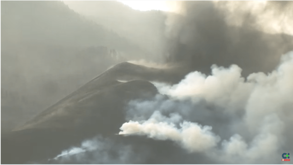
Fig 10: The volcano taking a short break this morning, looking deceptively tranquil. The main cone is in the centre of the image. Source: screen shot from TV Canarias: www.youtube.com
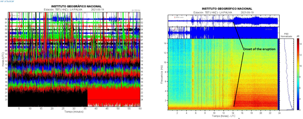
The eruption is now in its ninth day. The volcano took a break for a couple of hours today, to resume with a thick ash column and a few explosions. The new seismic swarm today may indicate that the volcano is recharging. It would be unusual for an eruption here to be so short.
The airport was closed for a period over the weekend while ash was cleared.
The cone broke in its southern section releasing a new lava which flowed over the older flow. The new lava reached speeds of 250 – 300 metres per second. Sadly, the church and other buildings in Todoque were razed.
Lava may now reach the sea. It is now between 800m and 1,000m from the sea, reaching the outskirts of Tazacorte. People in San Borondón, Marina Alta, Marina Baja and La Condesa are confined to their homes with their doors and windows closed due to the risk of ash and gases. We can only imagine the stress they are under right now.
There have been up to 4 eruptive centres and two lava flows. New emission points emerged in the NE section of the cone; they have since merged.
On 26 September 2021, the lava covered an area of 2.62 km2, with an average thickness of 12.1 metres a maximum thickness of 50 metres and a volume of 31 million cubic metres. The latest estimate of damage at the time of writing is that over 500 homes and 237.5 hectares of land are now covered by lava. 18.9 km of roads have been destroyed. 1,507 hectares of land are covered by ash.
The Ramón Margalef is to carry out a survey of the sea floor to check for submarine emissions.
The explosive phase, combined with the opening of new vents on the south west of the cone, has led to the evacuation of Tajuya, Tacande de Arriba and Tacande de Abaja.
The total number of evacuated is now 6,200.
Large pyroclastic materials are being ejected, and highly fluid lava with speeds of 60-80m/s is being discharged from the new vents.
There are fears that the main cone may collapse as a result of new vents and more explosions. This would lead to high-speed pyroclastic flows. You cannot outrun a pyroclastic flow.
The eruption column reaches 6km above sea level.
Although airspace is still open, Iberia, CanaryFly and Binter have suspended flights to / from La Palma, and Vueling has cancelled its Saturday flight from Barcelona to La Palma.
The Roque de los Muchachos Observatory has closed its telescopes to protect the mirrors from ash; it is still monitoring the gas and ash clouds from the volcano.
Lava covers 190 hectares; 420 buildings and 15.2 km of roads have been lost.
The area impacted by the volcano to be formally been declared a disaster zone.
It is thought that the older lava flows are slow due to the gradients they are on; they may speed up if they hit a higher gradient.
The eruptive style has changed from effusive to more explosive: of the two lava flows, the northern flow has nearly stopped and the southern is c.2,100 metres from the sea, advancing at 4 metres per hour having fanned out. It is now thought that it is unlikely that lava will reach the sea. IGN have reported several large explosions.
The aviation code for La Palma has been raised from orange to red, due to gas and ash. Airspace remains open except for two restricted areas. Airlines are advised to get flight plans checked before planes depart.
2 more fissures have opened since our previous update.
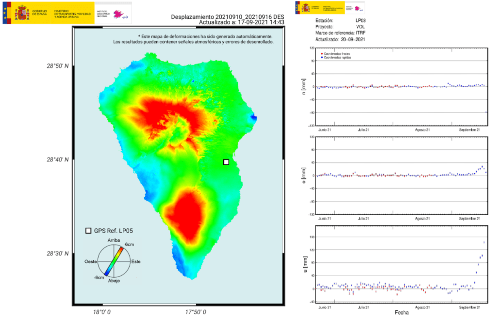
Ground uplift is now c. 24cm.
26 million cubic metres of lava have been emitted, razing 220 hectares of land and covering 180.1 hectares. The northern flow is 12m thick at the front and the southern flow, 10m thick.
390 properties and 14km of roads have been destroyed.
Banana harvesting has been suspended in the area to allow people to collect their belongings.
Farmers in restricted areas require permission from PEVOLCA to irrigate their crops.
More than 6,000 people have been evacuated to date.
The Official College of Psychology of Santa Cruz de Tenerife has reminded us that those losing property to the eruption are suffering trauma; they are not helped by seeing images of this repeated multiple times on social media.
Sources: El Mundo (link below) & IGN-CNIG (link above)
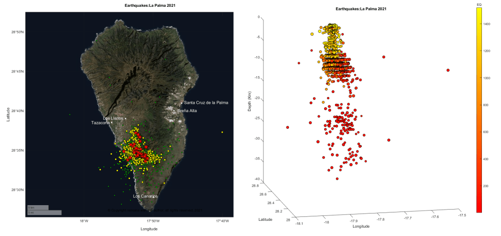
We have updated our earthquake plots for the current swarm. We have put them together in a short video.
Air traffic is not affected; the airport remains open. Visitors are encouraged to the island.
166 homes have been confirmed as lost. More than 6,000 have now been evacuated.
Land covered by lava will not be cultivatable; to date, 103 hectares of land are covered. Contaminated soil may take 20 years or more to be usable. Loss of land is expected to cause considerable poverty.
Lava is approaching the Todoque in Los Llanos de Aridane.
Several roads are closed in the vicinity of the eruption: LP-211, LP-212, LP-213, LP-215 and LP-2.
At the time of writing lava has not been reported as reaching the sea. When it does, clouds of toxic and acid vapours, including chlorine, sulphur, carbon and hydrogen sulphides, hydrochloric acid, carbonic acid and CO2, will be released, forcing further evacuations.
SO2 emissions reached between 7,997 – 10,665 tons per day on the second day. SO2 emissions have reached the cost of Africa.
It is too early to say how long the eruption will last. The 1971 Teneguía eruption lasted 24 days and the 1949 Cumbre Vieja eruption lasted 33 days.
20.09.2021
No lives have been lost or injuries reported.
The airport remains open. Air traffic is not currently affected.
2 fissures had opened 200m apart, with 8 vents.
The temperature of the lava is over 1,000°C (last reported: 1,113°C).
The ground is continuing to inflate; more earthquakes are possible.
The south west coast of the island is at risk of landslides and rock falls.
The lava discharge rate is 0.7km per hour. The lava is expected to reach the ocean at c.8:00pm (has not happened yet; the lava slowed and diverted). When the lava reaches the ocean, toxic vapours will be released due to the chemical reactions between the hot lava and sea water; the areas impacted would be Tazacorte, near Playa Nueva, Los Guirres.
Between 6,000 and 9,000 tons per day of SO2 were emitted on the first day.
5,500 people evacuated.
A 3.8M earthquake signalled the opening of a new vent (the 10th) 900m from the main vent. The new stream of lava led to the evacuation of Tacando.
An earthquake swarm which started on 11 September 2021, accompanied by uplift, resulted in PEVOLCA raising the alert level for La Palma to yellow on 13 September 2021.
The eruption, itself, started on 19 September 2021 at 2:15pm (UTC) in Cabeza de Vaca, El Paso; the alert level is now red. c.5,000 people have been evacuated. To date, no lives have been reported as lost, property damage is yet to be assessed. Our thoughts are with those affected.
Fig 1b: Displacement and ground deformation measured pre-eruption. On the left, displacement is for the period 10/09/2021 and on the right, deformation is for the period June 2021 to September 2021 (to date). Source: IGN (link below).
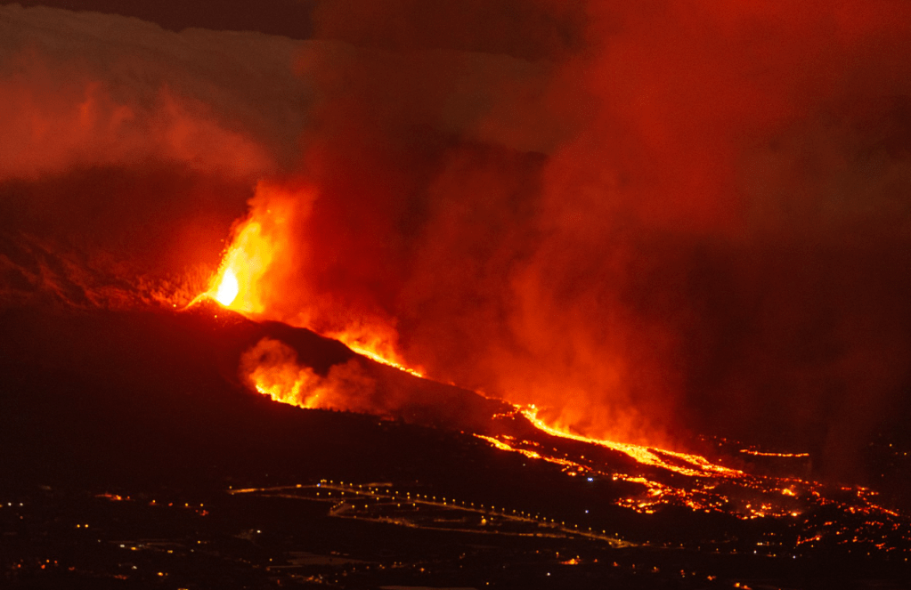
At the time of writing, there are lava fountains and a large lava flow that is threatening people’s homes.
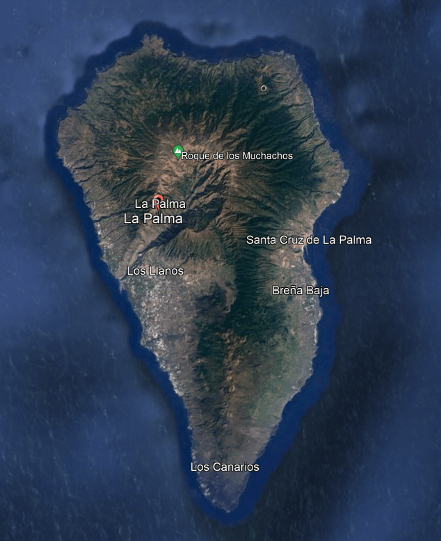
La Palma is a volcanic island with an area of 708 km2, located at the northwest end of the Canary Island archipelago above the Canary Island hotspot. The population of the island is c85,840; 15,720 live in the capital Santa Cruz de la Palma and 20,470 in Los Llanos de Aridane. The climate is tropical semi-arid. Its economy relies on agriculture and tourism; banana cultivation is centred in the valley of Los Llanos de Aridane; and, other crops include oranges, avocados and grapes. Fishermen operate from Tazacorte, Puerto Naos and Santa Cruz de la Palma. The island has abundant flora and fauna.
The island is comprised of many volcanoes, including an extinct Pliocene – Pleistocene northern shield volcano and the active Pleistocene – Holocene Cumbre Vieja. Cumber Vieja is the most active volcano in the Canary Islands, last erupting in 1971.
The northern shield lavas comprise basanites, alkali basalts, tephrites, phonolites and trachytes, reflecting magma evolution during the shield-building stage. The younger Cumbre Vieja volcano has more basaltic lavas.
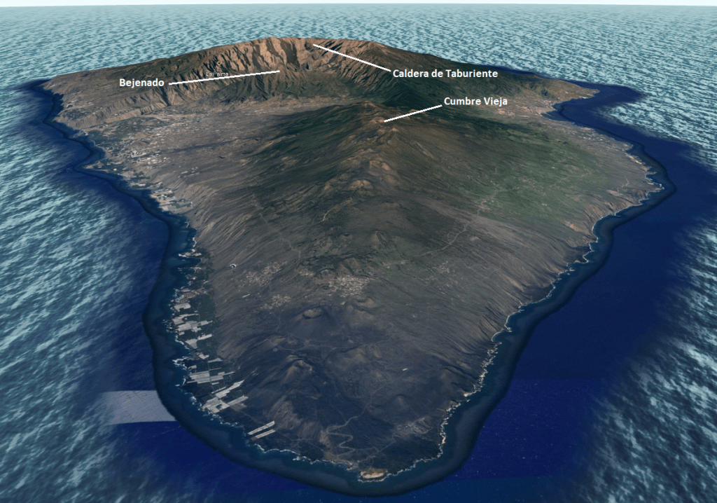
Fig 3: Caldera de Taburiente, Bejenado and Cumbre Vieja. Source: Google Earth
Building the Island
The island emerged in five stages: the initial submarine-building of a seamount, followed by the creation of four volcanoes during the shield-building stage, as shown below.
Time scale
Volcano
Lavas
Pliocene
Sea-mount
Basalt, trachybasalt, phonolite, trachyte
1.7Ma -1.2Ma
Garafía
Basalt
1.2Ma – 0.4Ma
Taburiente
Basalt, tephrite, phonolite
0.56-0.49ka
Bejenado
Basalt, tephrite, phonolite
125ka-present
Cumbre Vieja
Basalt, basanite, trachyte, phonolite
Garafía is covered by the later Taburiente volcano; its rocks being visible only in a few outcrops. Around 1.2Ma gravitational collapse of its southern flank left debris avalanche deposits in the sea.
Activity at Taburiente volcano commenced without a break following the collapse at Garafía. Its growth included the development of triple rift zones – parallel swarms of dikes at c 120° angles, indicative of magma doming. Activity then migrated southwards.
A landslide, clearly visible on maps, occurred between the building of Taburiente and Bejenado, and was responsible for the creation of the Caldera de Taburiente. Bejendo volcano is a small volcano that emerged to fill the collapse embayment. Subsequent erosion enlarged the caldera.
Cumbre Vieja emerged after activity had ceased in the north. From c. 125,000 years ago, volcanic activity built the north-south ridge until 80,000 – 20,000 years ago when activity declined. From 20,000 – 8,000 years ago activity picked up again, focusing on the north-south rift and also north-west and north-east rifts. Activity now focuses on the north-south rift. There is concern that another flank collapse could occur following the emergence of west facing normal faults during the 1949 eruption.
Eruptive History
GVP records 13 Holocene eruptions for La Palma, seven of which were VEI 2s, with mild explosive activity and lava flows that caused property damage (the remaining 6 have not been assigned a VEI number). Eruptions during the last 7,000 years have formed cinder cones and craters along the north – south axis of Cumber Vieja. Lava flows reached the sea in 1585, 1646, 1677-78, 1712, 1949, and 1971; a large lava field emplaced during the 1677-78 eruption covers the southern tip of the island.
GVP lists the lava types as Trachybasalt / Tephrite Basanite, Phono-tephrite / Tephri-phonolite, Phonolite, Basalt / Picro-Basalt, Trachyte / Trachydacite.
Seismic Activity
The current swarm was preceded by others: one in 2017, one in 2018, five in 2020, and three in 2021. The earthquakes in the previous swarms were deeper, between 20 and 30 km, and were less intense than the current swarm.
We have downloaded the earthquake data from IGN for 2021 to 19.09.2021 11:09 to see what has been going on. While these are only the earthquakes that have been located (there are thousands that have not), the plots clearly indicate magma ascent.
We do not have a precise location for the vents of the current eruption so are unable to compare it to the earthquake plots.
If you wish to follow the eruption as it progresses, IGN has up to date information on the eruption at La Palma on: Instituto Geográfico Nacional (ign.es).
