Tag Archives: fractional crystallisation

La Palma, 2021: Earthquakes and Magma Plumbing

Fig 1: Screenshot of the main cone of the current eruption, taken 19 October 2021. Source: TV Canarias, https://www.youtube.com/channel/UCTQrUTmzCWIfG6h4EVCdOCQ

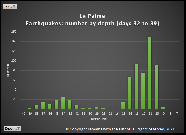
We have updated our earthquake plots to 19.10.2021 8:41:10.  Since our previous update there has been more seismic activity, mainly between depths of 9-15km and 32- 42km.  The former is consistent with the initial and subsequent stages of the swarm; the latter is consistent with the deeper earthquakes which started on day 21 (1.10.2021).

Fig 2: Analysis of earthquakes, number by day, by the author for days 32 (12.10.2021) to 39 (19.10.2021) at La Palma.  © Copyright remains with the author; all rights reserved, 2021.

Update earthquake plots are contained in the following video.

Fig 3: Video by the author of geoscatter plots and scatter plots by day of the earthquake swarm on La Palma from day 1 (11.09.2021) to day 39 (19.10.2021).  Note: day 19 is not a complete day.  © Copyright remains with the author; all rights reserved, 2021.

Magma Plumbing under Cumbre Vieja

We’ve Googled around to see what’s likely to be going on at these depths.  The 1585, 1949 and 1971 eruptions may shed some light on this.  Researchers have found that the erupted lavas are formed by fractional crystallisation and stored in the upper mantle; during ascent, these lavas stall in the lower crust or near the Moho; there are no long-lived shallow magma reservoirs.  

Fractional crystallisation is an indicator of the depths at which magma stalls in reservoirs.  Earthquakes tend to occur  around magma reservoirs or during the ascent of magma in response to the stresses on rock that changes in magma produce. Hence our interest in them.

The 1585 eruption produced 0.03km3 of lava, which was composed of basanites, tephrites, tephriphonolites and phonolite.  The eruption is famous for the extrusion of phonolitic spines, named “Devil’s horns” by eye-witnesses, at the start of the eruption.  Examination of the 1585 lavas indicate that the more evolved lavas were the result of fractional crystallisation.  Magma differentiated at three levels: in the deeper mantle, c.20km depth, basanite evolved to tephrite 1550 to 1750 years, collecting in more than one reservoir, before the eruption;  basanite also stagnated at the base of the crust, c.14km depth, to differentiate to tephrite; and, differentiation also occurred in the edifice.  Further evolution of to tephriphonolite / phonolite may have occurred in the lower crust and upper crust. The basanite erupted may have originated from a different batch of magma than the erupted tephrite.  14km is the depth of the Moho under La Palma.

The 1949 eruption started on 24 June 1949 and ended on 30 July 1949. It had been preceded by weak seismic activity from 1936.  Seismic activity picked up in February 1949, being felt mostly at the southern tip of the island and accompanied by ground cracking.  Stronger seismicity and ground cracking immediately preceded the opening of the first vent. The primary melt was sourced at depths between 80-100km.  Fractional crystallisation occurred at 20 to 26km with some possibly at 26-36km. Magma was stored temporarily in the crust before eruption. Magma mixing occurred in the mantle three months prior to eruption, causing a dike to propagate southwards. A 3km long fissure eruption started with the Duraznero crater emitting tephrite for 14 days.  This was followed by the Llano Blanco crater opening to erupt tephrite for three days, followed by basanite for three days.  The Hoyo Negra crater opened 4 days later to erupt basanite, tephrite and phonotephrite, during which the Llano Blanco crater continued to erupt basanite. The Duraznero crater then erupted basanite.  The eruption started on 24 June 1949 and ended on 30 July 1949. The primary melt was sourced at depths between 80-100km.  Fractional crystallisation occurred at 15 to 26km with some possibly at 36km. Magma mixing occurred in the mantle three months prior to eruption, causing a dike to propagate southwards. Magma was stored temporarily in the crust between 7-14km before eruption.  Later calculations put the depth of fractional crystallisation at 35-45km.

In 1971 Cumbre Vieja erupted again, this time at Teneguía, emitting 135,000 m2 of lava and created a 290,000 m2 lava platform – 40 million m3 of lava in total.  This eruption produced basanitic to phonolitic lavas.  The eruption was Strombolian and in two phases: initially a 300m fissure opened on 26th October 1971, producing effusive lava flows from vents; and, new vents opened on 8th November 1971, with rhythmic explosions, lapilli, scoria and lava bombs.  CO and CO2 were emitted; these gases were thought to be the cause of death for the eruptions two fatalities.   Examination of the lavas showed that magma stalled at two depths:  clinopyroxene and plagioclase crystallised at depths of 20-45km; and the crystallisation of aluminium augite indicated that magma then ascended to 20-35km.  Variations in the samples tested indicates that magma formed in batches over a range of depths in the lithospheric mantle to combine before ascent.

Taburíente, Cumbre Nueva and Bejenado each have zones of clinopyroxene crystallisation between 25-45km.  Earlier Cumbre Vieja eruptions had shallower zones of 15-30km, before the deeper zones of the 1949 and 1971 eruptions (35-45km and 25-45km, resp.).  In the earlier Cumbre Vieja eruptions magma stalled beneath the Moho and the in the later eruptions magmas depths were more in line with Taburíente, Cumbre Nueva and Bejenado.

How does this Compare to the Current Earthquakes?

To make any conclusions we need to wait until there is a detailed analysis of the erupted lavas. However, we can note that the current earthquakes are at two distinct depth ranges:  7 -16km and 30 to 42km, with not much in between.  7-16km correlates to a possible zone of magma storage beneath the crust and magma migration through the crust.  30 to 42km correlates to part of the lower zone of fractional crystallisation of the 1949 and 1971 magmas. 

Time will tell how this eruption will pan out.  In the meantime, the eruption is still going strong.  Our thoughts continue to be with those affected.

Armchair Volcanologist

© Copyright remains with the author; all rights reserved, 2021

Sources and Further Reading:

Raw earthquake data: Instituto Geográfico Nacional (ign.es)

Kursten Galipp, Andreas Klügel, Thor Hansteen, “Changing depths of magma fractionation and stagnation during the evolution of an oceanic island volcano: La Palma (Canary Islands)”, Journal of Volcanology and Geothermal Research Volume 155, Issues 3–4, 15 July 2006, Pages 285-306. Link: Source

T. S. Johansen F. Hauff K. Hoernle , A. Klügel, T.F. Kokfelt, “Basanite to phonolite differentiation within 1550–1750 yr: U-Th-Ra isotopic evidence from the A.D. 1585 eruption on La Palma, Canary Islands”, Geology; November 2005; v. 33; no. 11; p. 897–900. Link: Source

Andreas Klügel , Kaj A. Hoernle, Hans-Ulrich Schminck , James D. L. White, “The chemically zoned 1949 eruption on La Palma (Canary Islands): Petrologic evolution and magma supply dynamics of a rift zone eruption”,  Journal of Geophysical Research, Vol 105, No. B3, Pages 5997-6016. Link: Source

Abigail K. Barker, Valentin R. Troll, Juan Carlos Carracedo, Peter A. Nicholls, “The magma plumbing system for the 1971 Teneguía eruption on La Palma, Canary Islands”, Contributions to Mineralogy and Petrology 170, Article number: 54 (2015).  Link: Source

Tambora 1815

This is the first of out famous eruptions series.  Why not start with one of the largest?

Fig 1: Tambora’s caldera by Tisquesusa, 2017; published under CC BY 4.0

Tambora produced one of the largest known eruptions in recorded history with a climate impacting VEI 7 and possibly the largest Holocene eruption (other contenders for a VEI 7 being Kurile Lake, 6440 BC, Mazama, 5700 BC, Kikai Caldera, 4300 BC, Cerro Blanco, 2300 BC, Thera (Santorini), 1620 BC, Taupo, 180 AD, Baekdu, 946 AD, and Samalas (Rinjani), 1257 ).

 Tambora’s once proud 4,300 m stratovolcano lost around a third of its height and acquired a 1 km deep, 6 km wide caldera over the space of a few days in April 1815.  Sumbawa and the surrounding islands were devastated. Climate abnormalities (cooling and severe storms) were noted round the northern hemisphere along with crop failure and famine.  Tambora is accredited as the cause of the 1816 “year without a summer”. The eruption released 50 km3 of magma, 150 km3 of tephra, 80 million tonnes of sulphur dioxide and 18 mega tonnes of fluorine, along with water vapour and other aerosols.

The eruption was chronicled by local eye witnesses.  However, the then lieutenant governor of Java, Sir Stamford Raffles, keen to develop trade in the area, was not so keen to broadcast it further afield to potential investors; outside the region, the eruption went largely unnoticed by the West, already distracted by the Napoleonic wars.

Geological Setting

Before the eruption, Sumbawa Island was a pleasant prosperous island, trading mung beans, corn, rice, coffee, pepper, cotton, wood and horses.  Despite a wealth of natural resources, the people to farm them were in short supply so there was also a large slave trade and piracy.

Tambora occupies the entire Sanggar Peninsula on Sumbawa Island in the Sunda Arc of the Indonesian Archipelago.  Here the Australian Plate subducts beneath the Sunda Plate at a convergence rate of 7.8 cm per year.  Plotting the earthquakes in the region for 1972 to date clearly shows the Wadati-Benioff zone, with volcanoes sitting around 70km above the descending plate. 

Fig 2: Scatter plot of the earthquakes showing the subduction zone (Wadati-Benioff zone) where the Australian Plate meets the Sunda Plate by the author.  Green dots represent earthquakes < 5M, yellow circles, 5M to 6M, red stars, >6M, blue triangles, some volcanoes. © All rights reserved, 2020

Tambora is a 60 km wide stratovolcano with trachybasalt and trachyandesite lavas.  She formed a caldera c.43,000 years ago which was in-filled by Pleistocene lava flows.  During the Holocene her eruptions have been explosive: three eruptions in the Holocene occurred before the 1815 event, identified by radiocarbon dating, 740 AD, 3050 BC, and 3910 BC; three further smaller eruptions have been observed since the 1815 event, 1819 VEI 2, 1880 VEI 2 and 1967 VEI 0, which extruded lava domes and small lava flows on the caldera floor.

1815 eruption

Tambora had been dormant for over a thousand years; magma cooling and fractional crystallisation had been occurring along with the exsolving of high-pressure magma; over pressurisation was happening. Tambora awoke in 1812 with minor activity during the period 1812 to 1815 while magma ascended from the reservoir c.4 km below the edifice. 

The 1815 eruption proper started with a short Plinian eruption on 5 April 1815 of trachyandesite, lasting two hours, producing a 33 km eruption column; the explosions were heard as far away as Sumatra and were confused with gun fire. Following this, between 5 April and 10 April, there was a relatively low level of activity. 

On the evening of 10 April, a second short Plinian eruption occurred, lasting three hours, producing a 44 km eruption column.  Pumice rained down on local villages for 2 hours.  Volcanic winds destroyed trees and property.  The eruption column collapsed as the vent was eroded.  Pyroclastic density currents (PDCs) raged over the next three to four days, creating phoenix ash clouds, covering the area in ash and destroying villages, along with inhabitants.  During this phase the volcano, no longer supported by magma, subsided, creating the current caldera.

Tsunamis were generated when the PDCs reached the sea.  Sanggar was engulfed in a four-metre high tsunami at around 10 pm on 10 April; this tsunami reached Java a couple of hours later with a height of two metres. 

Explosions were heard during the night of 10 to 11 April up to 2,600 km away.  Locations within a 600km radius suffered darkness for a couple of days and a chilling of the atmosphere while sunlight was blocked. 

Seven or more ignimbrite layers were deposited during the second phase of the eruption.  Only 2.6 km3 of deposits remain on dry land; the heavier ejecta ended up in the sea and lighter aerosols were scattered round the globe.  Pumice rafts up to 5 km wide and trees trunks littered the Flores Sea, providing a hazard for shipping for several months.

Eruptive activity continued intermittently up to August 1819. 

Local and global impact of the eruption

Sumbawa was stripped of its vegetation. The death toll in Sumbawa and neighbouring Lombok was in the order of 60,000, 10,000 from the eruption itself with the remainder from disease and famine from polluted water and loss of crops and livestock.  Children were sold into slavery in order for them to survive or apparently killed to avoid a slow death from starvation or worse. 

The effects were also global.  The volcano had lobbed 50 km3 of matter plus gases into the stratosphere.  Larger particles fell back to Earth but smaller aerosols hung around for three years causing adverse weather phenomena (e.g. storms), global cooling, failed harvests, famine and disease in much of the northern hemisphere.

The global effects were exacerbated, according to ice-core sampling, by another large catastrophic eruption in 1809.  The source for the 1809 has yet to be identified; the volcano and eye witnesses may not have survived the eruption.  However, the 1809 and 1815 eruptions together caused a little ice age.

Can this happen again?

VEI 7 eruptions are rare.  As mentioned earlier, there are currently only eight other contenders in the Holocene. That is not to say they won’t happen again in the future. 

My guess is that to get another large event, not only do you need a large magma source and a build-up of pressure but also an element of edifice failure.  The largest part of the Tambora eruption in terms of magma output was while the PDCs were in full swing; these occurred as or after the vent eroded.  We will see in the accounts of other eruptions, there was some edifice failure.

In the meantime, Mount Tambora and her Indonesian sisters are well-monitored.

The Armchair Volcanologist

6 July 2020 (updated 23/08/2020 & 25/08/2020 to include more potential VEI 7s (the list is getting longer!)

© Copyright remains with the author; all rights reserved, 2020

Sources and Further Reading

“Volcanoes, Earthquakes and Tsunamis”, David A. Rothery, Teach Yourself, 2010.

“Volcanoes”, Second Edition, Peter Francis, Clive Oppenheimer, Oxford University Press, 2004

“Tambora: The Eruption That Changed the World”, Gillen D’Arcy Wood, Princeton University Press, 2014

Mount Tambora – Wikipedia, https://en.wikipedia.org/wiki/Mount_Tambora

Earthquake data from Incorporated Research Institutions for Seismology (IRIS) Earthquake Browser: http://ds.iris.edu/ieb

Plot by the author.

The Magic of Magma

Good Afternoon!

Magma is the molten source of many of the rocks at the Earth’s surface; the others come from meteorites or other terrestrial processes.  Here, we look at how magma is generated and how it affects volcanic eruptions.   This is a long one; you may want to dip into it as a reference rather than read it all in one go, but bear with me.

Fig 1: Holuhraun on 4 September 2014 by peterhartree.  Published under CC BY-SA 2.0. Note the fire fountains, effusive lava flows and gas emissions.

There are several different types of volcanic eruption, varying from effusive to explosive.  The type is determined by the magma composition- both its silica content and its volatile (gas) content.

How is magma generated?

From our earlier post, we know that the heat required to generate magma comes from nuclear reactions at the Earth’s core.  This heat makes its way to the surface via conduction, convection and radiation.  The surface rocks are cold enough to be solid.  However, we saw that the heat from the core drives plate tectonics; it is the variations in temperature and pressure caused by plate motion, combined with changes in rock composition, that create the conditions for rocks to melt and create magma.

Effusive Continental Rifts / Ocean Ridges

Effusive eruptions (think Hawaiian eruptions such as Kilauea) tend to occur at rifts or fissures, cracks in the Earth’s crust that let magma reach the surface relatively quickly and allow gases to escape gently.  Such fissures are common at constructive plate boundaries (continental rifts or mid ocean ridges), caused by plate separation.  Magma is generated in a process called decompression melting; as the plates move apart the overlying pressure is reduced, which in turn reduces the melting temperature of the mantle.  Because magma ascends relatively rapidly there is less time for it to mix with other magma or the crust.  This magma tends to be basic basalt. 

Magma ascent at ocean ridge
Fig 2:  Magma ascending at a Mid Ocean Ridge by the author after the many examples available.  Arrows denote plate motion.  Not to scale. © All rights reserved, 2020.

More Explosive Subduction Zones

Magma may also be generated at what is called subduction zones.  Subduction zones occur where plates meet: a denser oceanic lithosphere descends beneath either a less dense continental lithosphere or other oceanic lithosphere. These zones were discovered by two scientists independently researching earthquakes, Hugo Benioff and Kiyoo Wadati. Earthquake foci delineate the descending slab; this zone may be referred to as the Wadati-Benioff zone.   Magma is created from the descending slab by a process called hydration melting: as the slab descends water is squeezed out which mixes with the overlying asthenosphere, lowering its melting temperature.  Hydration melting occurs between 50 km to 200 km, with volcanoes accumulating at around 70 km above the descending slab.  

Magma mixes with the asthenosphere and the crust which increases its silica content. Partial melting of the mantle results in basalts (<52% silica); partial melting of the descending ocean crust provides andesites (52% to 65% silica); and, partial melting of the continental crust gives rhyolites (> 65% silica).  Increasing the silica content of the magma increases its viscosity and the explosivity of eruptions.

These plate boundaries are called destructive boundaries; it is believed that the descending plate is destroyed in the process. 

Fig 3:  Magma generation at a subduction zone by the author, after the many sources available.  Large arrow denotes plate motion; stars, the site of hydration melting; and, the smaller arrow, magma ascent.  The accretionary wedge is rock scraped off as the plates meet. Earthquake foci, not shown, would indicate the path of the descending plate. Not to scale. © All rights reserved, 2020.

Obduction

There is another process where plates meet called obduction; one plate rides over the other.  It is mentioned because obduction revealed the origins of oceanic crust.  Ophiolites, the remnants of old oceanic crust, show that this crust is made up of peridotites from the mantle overlain by old magma chambers, sheet dyke complexes, pillow lavas and sediments.  The magma was sourced from partial melting of the peridotite.  Sheet dyke complexes are complexes of vertical magma intrusions where magma has filled gaps caused by extension from plate separation.  Pillow lavas occur when basalt is erupted underwater.

Magma Evolution

We know that not all magma is basic basalt: there are others, including andesite and rhyolite.  These are formed from basalt by a process called magma evolution.

Magma rises slowly under its natural buoyancy, being around 10% less dense than the surrounding rock.  It tends to accumulate in magma chambers / reservoirs at depths of around 5 km to 20 km below the volcano.  Magma evolves by one or more of the following:

  • Magma mixing: one batch of magma mixes with another in the magma reservoir;
  • Assimilation: the rising magma collects surrounding rock during its ascent;
  • Fractional crystallisation: as magma rises, it cools, which causes the components with higher melting points to crystallise out.

Evolution tends to increase the silicate content of the magma and increase its viscosity; the higher the viscosity, the slower magma moves.

The table below shows a comparison of rock and magma compositions for some its key elements.  The convention for magma composition is based on the oxide equivalents of the elements, presumably on the basis that oxygen does not occur on its own in rock. 

Fig 4:  Comparison of key elements in the composition of different magmas by the author after various sources.  © All rights reserved, 2020.

So how does magma get to the surface?

The short answer is plate tectonics. Distortions in the crust from plate motion either squeeze magma out via existing or new fractures, or provide a wide enough pathway for the magma to ascend.  This is why we see so many volcanoes around plate boundaries.

Eruption Style

Magma contains dissolved gases (e.g. water, carbon dioxide, sulphur, and halogens: chlorine and fluorine).  When the constraining pressure decreases, the gases are released from solution: e.g. carbon dioxide exsolves at depths of several kilometres and sulphur at around 1 km.   This is a process called degassing (think of carbon dioxide released from a fizzy drink when the cap is loosened.) These gases may be held in the magma as bubbles or it may escape via fractures in the crust to the surface.  Measuring gas emissions around volcanoes indicates whether or not new magma is close to the surface.  We have seen with Grímsvötn that Icelandic scientists have reported the presence of sulphur dioxide near the caldera rim, indicating that Grímsvötn may be heading for a new eruption.

Effusive eruptions tend to occur with the less viscous basaltic magmas from which gases can escape gently.  More explosive eruptions are caused when the gases are trapped in more viscous magma and accumulate either as foam or as bubbles; it is their rapid expansion causes an explosive eruption. If a degassing event is large enough, less viscous magmas may also produce explosive eruptions.

When gas bubbles coalesce and expand, large bubbles form which rise with the magma.  If the magma reaches the vent, the bubbles explode with the reduction in constraining pressure, throwing out chunks of lava and ash; some of the chunks can be large boulders.  If gas bubbles get trapped in the magma chamber, when the accumulated pressure is high enough, the gas is forced out as a jet strong enough to cause fire fountains from less viscous basaltic magmas or ash / shards from fractured more viscous magma.  Fire fountains are / were visible in some of Etna’s eruption, in the 2014 eruption at Holuhraun or in the 1783 eruption of Laki. Famous explosive eruptions include Pinatubo, 1991, Krakatau, 1883, and Vesuvius, 79AD,

Impact of ground water or ice

We have seen explosive eruptions from some of Iceland’s basaltic volcanoes.  Another source of volatiles is ground water (aquifers) or glaciers.  When magma gets close enough to these, the heat from the magma flashes the water to steam; the rapid expansion of the water / steam results in an explosive eruption.  If only old rock is involved, the eruption is referred to as phreatic; if new magma is involved, the eruption is referred to as phreatomagmatic.  Phreatic eruptions may be a vehicle to clear the vent / provide a pathway for new magma to reach the surface. Recent phreatic eruptions include White Island, 2019, Mount Ontake, 2014; both caused loss of life because of the unpredictable nature of this eruption type.

Future Topics

There is another important process for magma that we have not touched here: mantle plumes.  We will look at this later.

We will also look in more detail the various locations for volcanoes, including the earthquake foci plots that indicate activity (usually tectonic).  Our Icelandic posts show the influence of the Mid Atlantic Ridge; others will look at subduction zones.

We may get diverted / distracted on the way to look at current events of interest.  (Probably, no “may” about it 😉 ).

Thank you for staying with me,

The Armchair Volcanologist

1 July 2020

© Copyright remains with the author; all rights reserved, 2020

Sources and Further Reading

“Volcanoes, Earthquakes and Tsunamis”, David A. Rothery, “Teach Yourself”, 2010

“Volcanoes”, Peter Francis, Clive Oppenheimer, Oxford University Press, 2004

“Volcanoes Global Perspectives”, John P. Lockwood and Richard W. Hazlett, Wiley-Blackwell, 2010

“Wadati-Benioff zone”, Wikipedia: https://en.wikipedia.org/wiki/Wadati%E2%80%93Benioff_zone

“Igneous rock”, Wikipedia: https://en.wikipedia.org/wiki/Igneous_rock

“Magma”, Wikipedia: https://en.wikipedia.org/wiki/Magma