Tag Archives: African Plate

Türkiye-Syria Earthquakes, 6th February 2023

Fig 1: Rescue workers in in Osmaniye, Turkey.  Cropped from image by Onur Erdoğan, Public Domain, Wiki Commons

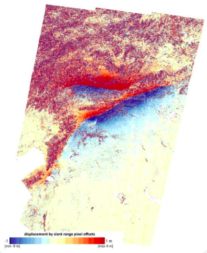
It’s approximately one month on from 6th February 2023 when a 7.8 magnitude earthquake struck on the south western end of the East Anatolian Fault Zone at 01:18 UTC (04:18 local time) 32.4km west northwest of the town of Gaziantep.  This, followed by large aftershocks, including a very shallow 7.5 magnitude earthquake to the north of the first quake, caused catastrophic damage in central and southern Turkey, and northern and western Syria.  The 7.5 earthquake signalled the rupturing of a second fault zone, the Sürgü-Misis Fault.  The final fatality number is not yet available but, at the time of writing, fatalities exceeded 50,000, with hundreds of thousands injured and millions displaced.  Our thoughts are with the victims, including those facing a long road to recovery.

We have taken a look at the earthquakes surrounding the Anatolian Plate from the start of January 2023 to 1st March 2023. 

Tectonic Settings

The Anatolian Plate lies between the Eurasian Plate, Arabian Plate and African Plate.  The African Plate is moving at a rate of 2.15cm per year in a north easterly direction, the Eurasian Plate is moving south, relative to the African Plate, at a rate of 7-14mm per year, the Arabian Plate is moving northward at a rate of 15-20mm per year and the Anatolian Plate is moving south west at the rate of 21mm per year. The relative motions are accommodated by the North Anatolian Fault, East Anatolian Fault, Bitlis – Zagros Fold and Thrust Belt and Dead Sea Transform Fault System.

Fig 2: Image by Roxy – Own work, CC BY-SA 3.0, Wiki Commons

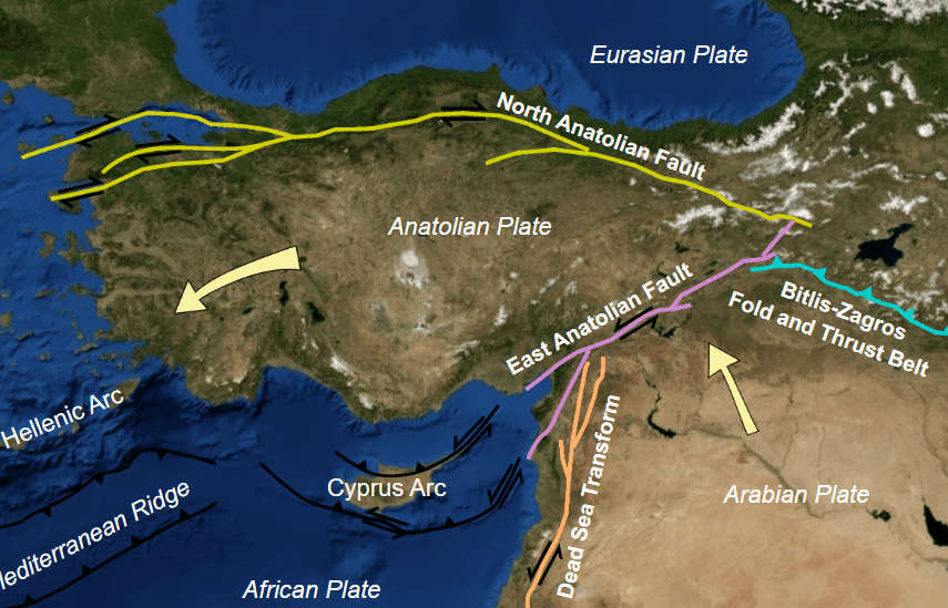
The East Anatolian Fault is a 500km long fault zone which marks the plate boundary between the Anatolian and Arabian Plates; the boundary is a transform one with left lateral strike slip seismic activity and a slip rate of 10mm per year. The Anatolian Plate is pushed westward by the Arabian Plate moving northwards towards the Eurasian Plate. 

The East Anatolian Fault is a single fault between Karliova and Çelikhan.  After Çelikhan the fault zone splits into north and south strand, both of which include multiple faults.  The Sürgü-Misis Fault makes up the northern strand; it is a 380km long stretching between Çelikhan and Karataş; the eastern parts of the east-west section are made up of the Çardak and Sürgü faults; the sytem changes direction at the Göksun bend dividing into seven north east trending fault systems – the Karataş, Yumurtalık, Toprakkale, Savrun, Misis, Çokak and Düziçi-İskenderun faults.  The Sürgü-Misis Fault system connects to the Cyprus Arc via the Misis-Kyrenia fault system.   The southern strand of the East Anatolian Fault is less certain; the East Anatolian Fault may extend to the north of Cyprus; and, the NNE trending Türkoğlu-Amik section (the Karasu Fault Zone) may be a separate fault, linking the Dead Sea Transform to the East Anatolian Fault. The Karasu Rift has had Quaternary volcanic activity on northern part and sides of the rift between Kirikhan, Reyhanli and Fevzipaşa in an area 94km long and 12-25km wide.

The North Anatolian Fault, another strike slip fault, accommodates the relative motion between the Anatolian Plate and the Eurasian Plate.  The North Anatolian Fault and the East Anatolian Fault meet the Bitlis – Zagros Fold and Thrust Belt, where the Arabian Plate subducts under the Eurasian Plate, at the Karliova Triple Junction.

Not very far to the west, the African Plate is subducting under the Anatolian Plate at the Cyrpus Arc.  The Dead Sea Transform Fault System to the south marks the transform boundary between the Arabian and African Plates.  The East Anatolian Fault meets the Dead Sea Transform Fault System at the Maras Triple Junction.

Earthquake Plots

We initially plotted the earthquakes from 1 January 2023 to 25 February 2023 for the area 34.47361°N, 25.22222°E to 42.25833°N, 44.45056°E.  We then looked at 35.3122°N, 32.50944°E to 41.21667°N, 42.70056°E, focussing on the East Anatolian Fault. The results are shown in the following videos and earthquake density plot.

Fig 3:  Video by the author of earthquake plots from 1 January 2023 to 1st March 2023, latitude v depth, Geoscatter, earthquake count and longitude v depth.  Key: cyan circles denote current earthquakes <4.5M, green stars, current earthquakes between 4.5M and 5.5K, yellow stars, current earthquakes between 5.5M and 6.5M and red stars, current  earthquakes over 6.5M; and, grey circles denote previous earthquakes <4.5M, green stars, previous earthquakes between 4.5M and 5.5K, yellow stars, previous  earthquakes between 5.5M and 6.5M ,and red stars, previous  earthquakes over 6.5M.  © copyright remains with the author, 2023; all rights reserved.
Fig 4. Video by the author of the Geoscatter plot of the East Anatolian Fault and by earthquakes in groups of 10 from 6 February 2023 to 1st March 2023.  Key: red circles denote current earthquakes <7.0M and red stars denote current earthquakes >7.0M, and dark red circles, previous earthquakes <7.0M and black stars, previous earthquakes >7.0M. © copyright remains with the author, 2023; all rights reserved.
Fig 5: Video of a rotating 3D scatter plot of the earthquakes in the East Anatolian Fault for the period 6 February 2023 to 1st March 2023. Colour denotes age: red, the oldest, and yellow, the newest. © copyright remains with the author, 2023; all rights reserved

The geodensity plot shows that most activity occurred on the Sürgü-Misis Fault to the west and east of the 7.5M earthquake.

Fig 6: Geodensity plot by the author of earthquakes occurring between 35.3122°N, 32.50944°E to 41.21667°N, 42.70056°E, from 6th February 2023 and 1st March 2023. Red triangles denote volcanoes with dated activity in the Holocene and blue triangles denote volcanoes with activity in the Holocene of unknown date. © copyright remains with the author, 2023; all rights reserved.
Fig 7: Surface rupture from the two earthquakes as shown by analysing before and after satellite images. The first rupture on the East Anatolian Fault was 190km long and the second on the Sürgü-Misis Fault was 38km long (Image credit: Copernicus/NERC/COMET)

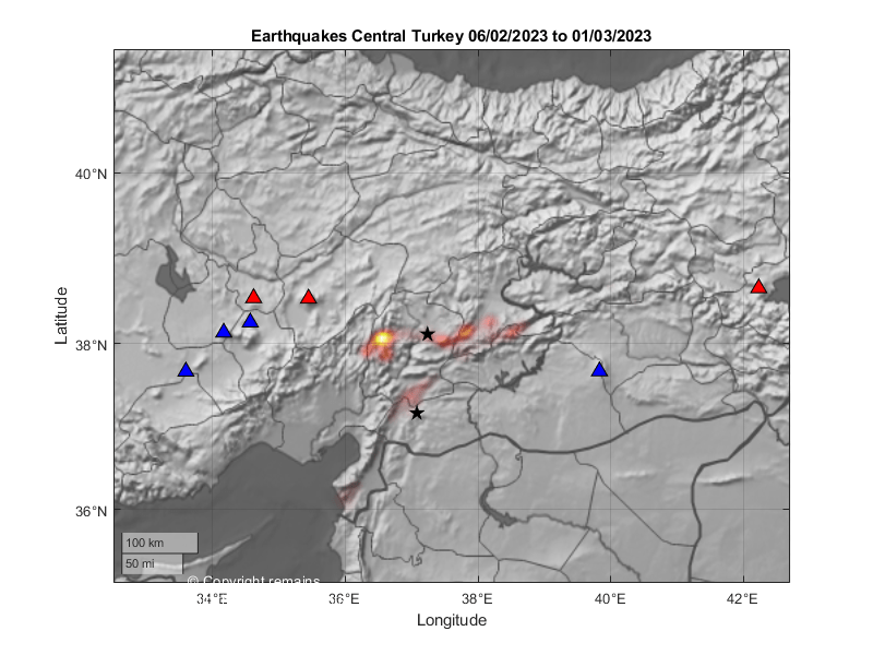
Most of the faults within the East Anatolian Fault Zone seem to have moved in the period we looked at. However, the scale of our plots may be misleading. Our plots do show a tenuous link between the East Anatolian Fault and the Cyprus Arc.  There was some activity on the Arc preceding the 7.8 earthquake. After shocks have migrated through the fault system towards the Arc.   There is no obvious link with the Dead Sea Transform Fault in the time period selected but geologically-speaking that is a very short period.

Armchair Volcanologist

© copyright remains with the author; all rights reserved, 2023.

Sources & Further Reading

Raw earthquake data was downloaded from EMSC, https://www.emsc-csem.org

“Paleoseismology of the western Sürgü–Misis fault system: East Anatolian Fault, Turkey”, Tamer Y. Duman, Hasan Elmacı, Selim Özalp, Akın Kürçer, Meryem Kara, Ersin Özdemir, Ayhan Yavuzoğlu & Çağıl Uygun Güldoğan,  Mediterranean Geoscience Reviews volume 2, pages411–437 (2020) https://link.springer.com/article/10.1007/s42990-020-00041-6

Tectonic Overview of the Aegean Sea Plate and Anatolian Plate

Good Afternoon!

Sadly, a 7.0 magnitude shallow earthquake occurred to the north of the Greek island of Samos on 30 October 2020.  This caused a number of fatalities, injuries and property damage in both Greece and Turkey.

This prompted us to take a look at the tectonics in the region.

Fig 1: Plot of earthquakes from 1 October 2004 to 6 November 2020 between 33.0°N, 19.0°E to 42.0°N, 44.0°E by the author, using earthquake data downloaded from EMSC. Green circles denote earthquakes ≤ 4.0M, yellow circles, 4.0M to 5.0M, orange circles, 5.0M to 6.0M, red stars >6.0M.  Blue stars denote the large earthquakes of the North and East Anatolian Faults from 1939 to 2003.  The location of 30/10/2020 earthquake is shown in the circle.  © Copyright remains with the author; all rights reserved, 2020.

Tectonics in East Mediterranean

Activity here is driven by the collision of the north eastern moving African Plate with the Eurasian Plate.  Of the microplates which have broken off the Eurasian Plate during the collision, we are interested in the Aegean Sea Plate and the Anatolian Plate.

Anatolian Plate

The African Plate subducts under the south and south west margins of the Anatolian Plate at the Hellenic and Cyprus arcs; there is a transform boundary with the Eurasian Plate on the northern edge at the North Anatolian Fault Zone (NAFZ); the western edge is a divergent boundary with the Aegean Plate; and, the eastern edge is the East Anatolian Fault which marks the transform boundary with the Arabian Plate.  The plate is rotating anti-clockwise, pushed westward at a speed of 21 mm per year relative to the African Plate by the northward motion of the Arabian Plate. 

The East Anatolian Fault extends from the Maras Triple Junction at the northern end of the Dead Sea Transform to the Karliova Triple Junction and North Anatolian Fault.

The North Anatolian Fault extends from the junction with the East Anatolian Fault at the Karliova Triple Junction to the Aegean Sea. This fault has produced several earthquakes of magnitudes in excess of 7.0 M, which since 1939 have been occurring along the fault in a westward pattern, until 1999.  There is concern that westward trend may be resumed to continue onwards to Istanbul, itself. 

Aegean Sea Plate

The African Plate subducts beneath the southern edge of Aegean Plate at the Hellenic Trench.  The northern edges of the Plate are divergent boundaries with the Eurasian Plate and the Anatolian Plate.  The plate is moving south westward at a speed of 37mm per year relative to the African Plate.

Samos is located in the Eastern Mediterranean on the Aegean Plate.  The 7.0 M earthquake on 30 October 2020 was the result of normal faulting in the Aegean Plate as part of the north-south extension caused by the accommodation of the relative motions of the plates and trench; i.e., northward motion of the African plate, southward motion of the Hellenic Trench and westward motion of the Anatolian Plate. 

Large earthquakes in the Aegean Sea are common; USGS notes that there have been 29 earthquakes over 6.0 M in the past 100 years. They highlight two damaging quakes: the July 1956 7.7 M quake and its 7.2M aftershock, which caused a large tsunami, 53 deaths, 100 injuries and damage on Amorgos and Santorini; and, a 6.6 M in July 2017 near Bodrum in Turkey which caused 2 deaths and many injuries in Turkey and neighbouring Greece.

Recent Seismicity

We plotted the earthquakes greater than or equal to 3.5 M between 33.0°N, 19.0°E to 42.0°N, 44.0°E (the area in the large rectangle in Fig 1) for the period 1 October 2004 to 6 November 2020 downloaded from EMSC’s earthquake search facility. In the period there were 13,034 earthquakes. 

From Fig 1 above, which shows the geoscatter plot of the earthquakes, we can get a rough outline of the plate boundaries.  However, some of the faults on the eastern side of the Aegean Sea Plate are accommodating the north-south extension of the plate so may not delineate the plate boundary, itself.  Although our dataset goes back as far as 2004, we have added the large earthquakes of the North and East Anatolian Faults from 1939 to 2003; these are shown in blue. It is interesting to note that there have not been any large earthquakes on the North Anatolian Fault in the Anatolian Plate segments since 1999.

Depth plots show the subduction of the African plate under the Aegean Sea Plate (Fig 2) and the Anatolian Plate (Fig 3). 

Fig 2: Depth plot of the earthquakes from 1 October to 6 November 2020 in respect of the Aegean Sea Plate by the author, using earthquake data downloaded from EMSC. Green circles denote earthquakes ≤ 4.0M, yellow circles, 4.0M to 5.0M, orange circles, 5.0M to 6.0M, red stars >6.0M.   © Copyright remains with the author; all rights reserved, 2020.
Fig 3: Depth plot of the earthquakes from 1 October to 6 November 2020 in respect of the Anatolian Plate by the author, using earthquake data downloaded from EMSC.  Green circles denote earthquakes≤ 4.0M, yellow circles, 4.0M to 5.0M, orange circles, 5.0M to 6.0M, red stars >6.0M.  © Copyright remains with the author; all rights reserved, 2020.

In Fig 2, we can clearly see that the descending plate under the Aegean Sea Plate reaches a depth of c. 200 km.  The subduction zone feeds the Greek volcanoes, Methana, Milos, Santorini, Nisyros and Yali.  There are also a few very deep earthquakes lurking in the area.

In Fig 3, we can see that the subduction zone under the Anatolian Plate does not descend as far as that under the Aegean Sea Plate.  This may be why the volcanoes in western and central Turkey have not erupted in the last few thousand years, although some have erupted in the Holocene.

Our thoughts are with those impacted by the 7.0 earthquake on 30 October 2020, and, indeed, with those adversely impacted by any earthquake.

The Armchair Volcanologist

11 November 2020

© Copyright remains with the author; all rights reserved, 2020

Sources & Further Reading

Information about the 7.0M 30/10/2020 earthquake was obtained from USGS: https://earthquake.usgs.gov/earthquakes/eventpage/us7000c7y0/executive

Raw earthquake data was downloaded from EMSC’s earthquake search: https://www.emsc-csem.org

Information about the plates was obtained from Wikipedia.

Aegean Sea Plate: https://en.wikipedia.org/wiki/Aegean_Sea_Plate

Anatolian Plate: https://en.wikipedia.org/wiki/Anatolian_Plate

North Anatolian Fault: https://en.wikipedia.org/wiki/North_Anatolian_Fault

East Anatolian Fault: https://en.wikipedia.org/wiki/East_Anatolian_Fault