Good Afternoon!
Sadly, a 7.0 magnitude shallow earthquake occurred to the north of the Greek island of Samos on 30 October 2020. This caused a number of fatalities, injuries and property damage in both Greece and Turkey.
This prompted us to take a look at the tectonics in the region.
Tectonics in East Mediterranean
Activity here is driven by the collision of the north eastern moving African Plate with the Eurasian Plate. Of the microplates which have broken off the Eurasian Plate during the collision, we are interested in the Aegean Sea Plate and the Anatolian Plate.
Anatolian Plate
The African Plate subducts under the south and south west margins of the Anatolian Plate at the Hellenic and Cyprus arcs; there is a transform boundary with the Eurasian Plate on the northern edge at the North Anatolian Fault Zone (NAFZ); the western edge is a divergent boundary with the Aegean Plate; and, the eastern edge is the East Anatolian Fault which marks the transform boundary with the Arabian Plate. The plate is rotating anti-clockwise, pushed westward at a speed of 21 mm per year relative to the African Plate by the northward motion of the Arabian Plate.
The East Anatolian Fault extends from the Maras Triple Junction at the northern end of the Dead Sea Transform to the Karliova Triple Junction and North Anatolian Fault.
The North Anatolian Fault extends from the junction with the East Anatolian Fault at the Karliova Triple Junction to the Aegean Sea. This fault has produced several earthquakes of magnitudes in excess of 7.0 M, which since 1939 have been occurring along the fault in a westward pattern, until 1999. There is concern that westward trend may be resumed to continue onwards to Istanbul, itself.
Aegean Sea Plate
The African Plate subducts beneath the southern edge of Aegean Plate at the Hellenic Trench. The northern edges of the Plate are divergent boundaries with the Eurasian Plate and the Anatolian Plate. The plate is moving south westward at a speed of 37mm per year relative to the African Plate.
Samos is located in the Eastern Mediterranean on the Aegean Plate. The 7.0 M earthquake on 30 October 2020 was the result of normal faulting in the Aegean Plate as part of the north-south extension caused by the accommodation of the relative motions of the plates and trench; i.e., northward motion of the African plate, southward motion of the Hellenic Trench and westward motion of the Anatolian Plate.
Large earthquakes in the Aegean Sea are common; USGS notes that there have been 29 earthquakes over 6.0 M in the past 100 years. They highlight two damaging quakes: the July 1956 7.7 M quake and its 7.2M aftershock, which caused a large tsunami, 53 deaths, 100 injuries and damage on Amorgos and Santorini; and, a 6.6 M in July 2017 near Bodrum in Turkey which caused 2 deaths and many injuries in Turkey and neighbouring Greece.
Recent Seismicity
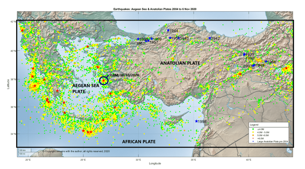
We plotted the earthquakes greater than or equal to 3.5 M between 33.0°N, 19.0°E to 42.0°N, 44.0°E (the area in the large rectangle in Fig 1) for the period 1 October 2004 to 6 November 2020 downloaded from EMSC’s earthquake search facility. In the period there were 13,034 earthquakes.
From Fig 1 above, which shows the geoscatter plot of the earthquakes, we can get a rough outline of the plate boundaries. However, some of the faults on the eastern side of the Aegean Sea Plate are accommodating the north-south extension of the plate so may not delineate the plate boundary, itself. Although our dataset goes back as far as 2004, we have added the large earthquakes of the North and East Anatolian Faults from 1939 to 2003; these are shown in blue. It is interesting to note that there have not been any large earthquakes on the North Anatolian Fault in the Anatolian Plate segments since 1999.
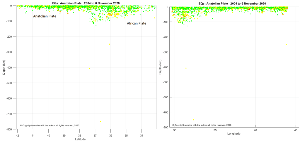
Depth plots show the subduction of the African plate under the Aegean Sea Plate (Fig 2) and the Anatolian Plate (Fig 3).
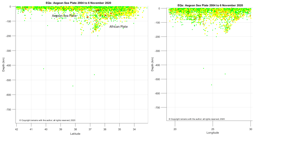
In Fig 2, we can clearly see that the descending plate under the Aegean Sea Plate reaches a depth of c. 200 km. The subduction zone feeds the Greek volcanoes, Methana, Milos, Santorini, Nisyros and Yali. There are also a few very deep earthquakes lurking in the area.
In Fig 3, we can see that the subduction zone under the Anatolian Plate does not descend as far as that under the Aegean Sea Plate. This may be why the volcanoes in western and central Turkey have not erupted in the last few thousand years, although some have erupted in the Holocene.
Our thoughts are with those impacted by the 7.0 earthquake on 30 October 2020, and, indeed, with those adversely impacted by any earthquake.
The Armchair Volcanologist
11 November 2020
© Copyright remains with the author; all rights reserved, 2020
Sources & Further Reading
Information about the 7.0M 30/10/2020 earthquake was obtained from USGS: https://earthquake.usgs.gov/earthquakes/eventpage/us7000c7y0/executive
Raw earthquake data was downloaded from EMSC’s earthquake search: https://www.emsc-csem.org
Information about the plates was obtained from Wikipedia.
Aegean Sea Plate: https://en.wikipedia.org/wiki/Aegean_Sea_Plate
Anatolian Plate: https://en.wikipedia.org/wiki/Anatolian_Plate
North Anatolian Fault: https://en.wikipedia.org/wiki/North_Anatolian_Fault
East Anatolian Fault: https://en.wikipedia.org/wiki/East_Anatolian_Fault
