Tag Archives: long period earthquakes

La Soufrière St. Vincent Eruption: The North East of St Vincent Island Has Been Devastated

Good Afternoon!

This update is based on news reported from St Vincent and The Grenadines and Barbados up to 14 April 2021 (edited 16.04.2021).

Fig 1: Ash covering vegetation in the red zone.  Image by Prof. Richard Robertson, UWI-SRC.

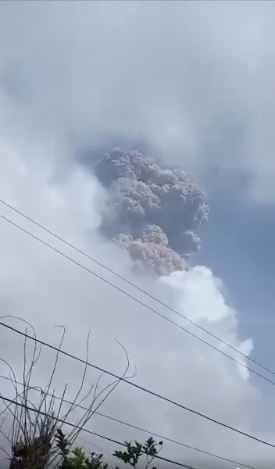
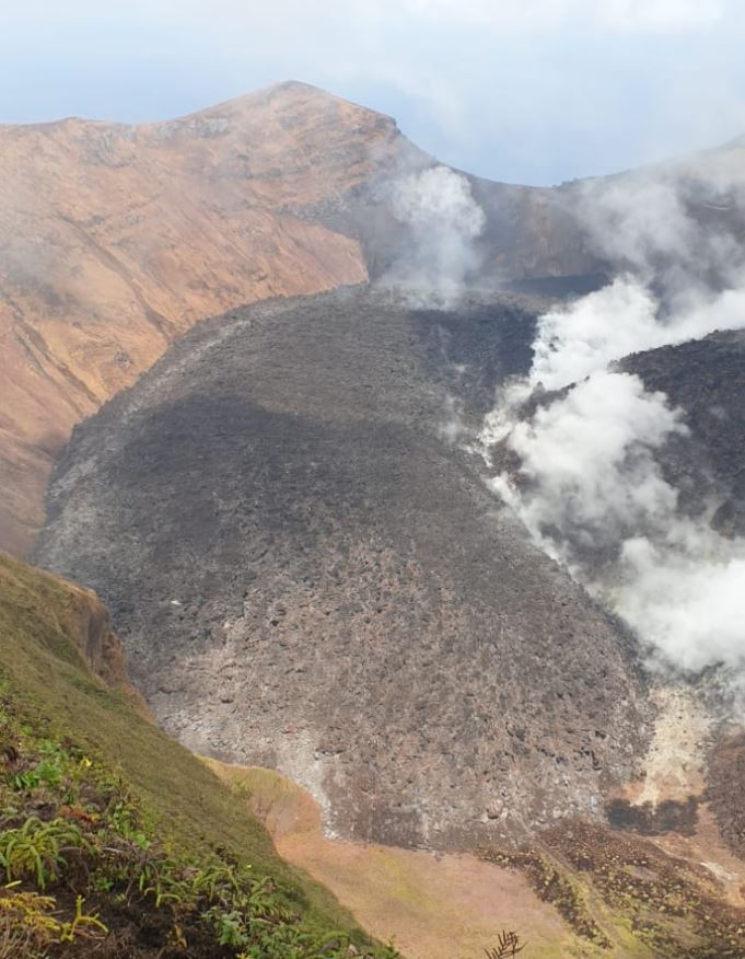
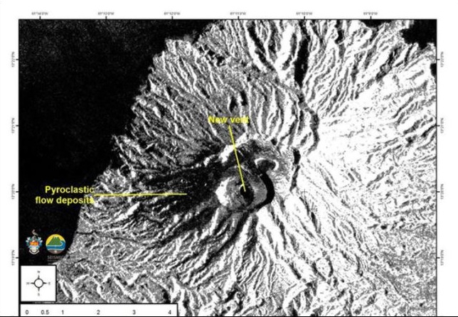
A new crater and vent were observed by satellites on 12 April 2021.  Both lava domes have been destroyed.

Fig 2: Satellite image from the European Space Agency of the new crater and vent.  The new vent and pyroclastic flows have been marked by UWI-SRC.

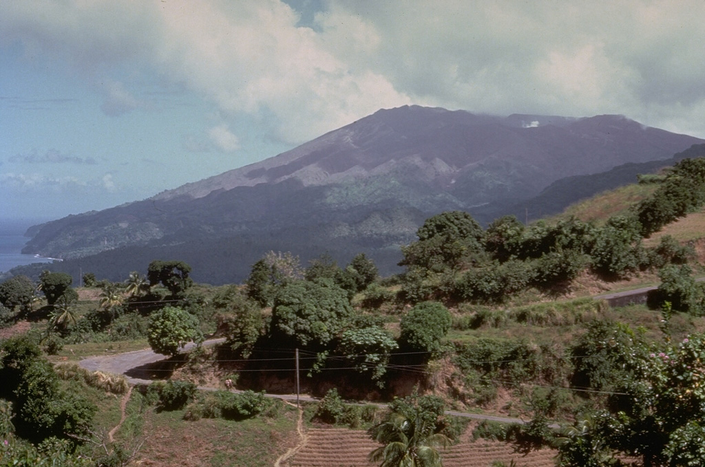
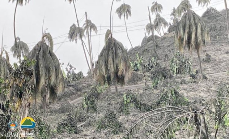
The North East of the island has been devastated; the agricultural area has been described by the Deputy Prime Minister of St Vincent & the Grenadines, Montgomery Daniel, as non-existent; trees and farms have been destroyed – only tree stumps are standing. He likens the damage to that caused by Hurricane Thomas. The crops lost include bananas, breadfruit, coconuts, mangos, soursop, plantains, arrowroot, dasheen and ginger and yams. The island’s economy is heavily dependent on the export of bananas and tourism.

Pyroclastic flows caused by ash columns collapse occurred on 13 April 2021, hitting the eastern side of the volcano.  Areas at risk are Georgetown, Sandy Bay, Owia, Fancy and other settlements.  Lahars have been reported by Sandy Bay.

Pyroclastic flows on 12 April were observed on the western and southern flanks of the volcano, reaching the sea at Morne Ronde, Larikai and Trois Lopues Bay.

Water supplies were contaminated by ashfall.  The water supply has been restored to most of the island excluding the red zone (Owia, Sandy Bay, Fancy and Heritage), having cleaned ash out of the supply systems.  Bottled water has been supplied from Barbados (although Barbados is suffering from ashfall as well).  Several other nations have sent water. Water testing kits have been supplied by the World Health Organisation and Pan American Health Organisation.

Loss of power supplies were reported on 11 April 2021. No mention has been made of their status since. But it can be assumed that every effort would have been made to restore them.

Venezuela is providing humanitarian support.  Guyana, Grenada and others have also sent supplies. Financial aid has been sent by other Caribbean islands, the UK (among others), the UN and the World Bank.

Barbados continues to get ashfall.  The opening of schools has been delayed to allow for a cleaning up operation (ash got in via ventilators and windows).  Ash has impacted water supplies in the north.

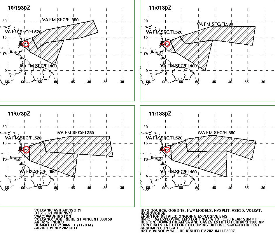
Explosions were occurring roughly 14 hours apart, with swarms of small long period earthquakes in between. It had been hoped that the explosive activity had waned for a while after a longer gap and that the continuing long period and hybrid earthquakes signified growth of a new lava dome, but another explosion occurred at 06:15 this morning (16.04.2021). SO2 levels indicate that fresh magma is arriving from a deeper source. The eruption is currently categorised as a VEI 4.  It is expected to continue for some time, following the pattern of the 1902 eruption.

The United Nations have stated that this humanitarian crisis could go on for some time and that it may extend to other nearby islands.

For updates, please use the sources below.

The Armchair Volcanologist

© Copyright remains with the author; all rights reserved, 2021.

Sources and Updates

St Vincent and the Grenadines:  News784 • St Vincent’s #1 News Source

Barbados: NationNews Barbados — nationnews.com

Alert Level for La Soufrière St. Vincent Raised to Red: Eruption in progress

Update 10.04.2021

At the time of writing, there have been several explosive eruptions now from La Soufrière St. Vincent.  The island has experienced extensive ashfall.  The emergency evacuation has extended to the orange zone.  Ash has reached 51,000 feet (38,000 feet, latest VAA) according to the volcanic ash alerts and the ash cloud has drifted over Barbados.

Fig 3: Ash plume from the first explosion.  Photo from NEMO

Most of the new lava dome has been destroyed and the 1979 lava dome has suffered some damage.  Removal of the rock has given magma a more open pathway.  The eruption is expected to be larger than the 1979 eruption and to continue for some time; explosions are expected to be the same or greater magnitude. As far as we know, there have not been any pyroclastic flows but they are expected. 

More than 3,000 people are in emergency accommodation and others are staying with friends or relatives.   Saint Lucia, Grenada, Antigua and Barbados have offered to take refugees.  Carnival Cruise Lines and the Royal Caribbean Group will send cruise ships to transport people to other islands. Venezuela has sent humanitarian aid and risk experts.

The north and west of Barbados have been hard hit by ash; the skies turned dark and ash is falling.  Residents have been advised to stay indoors, except for essentials or a medical emergency.  Beaches, parks and fish markets are closed for the time being. People with respiratory disorders have been advised to have their medication with them at all time.  The airport and airspace is closed at the moment.

Latest VAA forecast:

Fig 4: Volcanic ash forecast from Washington VAAC Volcanic Ash Advisory (noaa.gov). The volcano is coloured in red and Barbados is in the red circle.

Thoughts with everyone affected.

Sources:

NEMO St. Vincent: ‪#‎lasoufriereeruption2021

Hazard zones, St Vincent: Home (nemo.gov.vc)

Washington VAAC: Volcanic Ash Advisory (noaa.gov),

News 784: NEMO: Explosive Eruptions May Continue Over The Next Few Days And Weeks • News784

Barbados Government Information Service: GIS News | GIS (gisbarbados.gov.bb)

Nation News, Barbados: Volcano ash turns northern skies dark – NationNews Barbados — nationnews.com

Update 16:51, 09.04.2021

An explosive eruption started at La Soufrière St. Vincent around 12:40 pm GMT today, sending an ash column 8 km into the sky. The ash cloud reached 20,000 feet, drifting eastwards. Ashfall has been observed at Argyle International Airport.

Scientists warn that further larger eruptions are possible.

The evacuation from the red zone (northern end of the island) is still in progress at the time of writing.

Source: NEMO St. Vincent and the Grenadines | Facebook

Original Post: 12:46, 09.4.2021

Good Afternoon!

Increasing gas emissions and seismic activity, including long period events, indicate that new magma is ascending at La Soufrière St. Vincent and an eruption could be imminent.  An immediate evacuation order was given earlier today (c.1:00 am GMT) for the red zone in the north of the island, impacting 16,000 people.

Fig 1: La Soufrière St. Vincent, seen here from the south. Photo by Richard Fiske, 1980 (Smithsonian Institution).

The new lava dome has been steadily growing since it emerged in December 2020.  The emission of gas and stream from the centre of the dome and its border with the 1979 dome increased on 8 April 2021.  A preliminary VAA noted that a well-defined hotspot was visible in the SW.   Incandescence from the dome was visible in St Lucia.

A swarm of volcano-tectonic earthquakes started on 6 April 2021 beneath the volcano at a depth of around 6 km.  Long period earthquakes have also been observed, indicating that new magma is ascending.

Fig 2: New lava dome on 19 March 2021 between the 1979 lava dome on the right of the image and the crater wall on the left.  Photo NEMO.

Background

Volcanic activity, here, is driven by the subduction of the South American Plate under the Caribbean Plate.

La Soufrière St. Vincent is a 1,234m high stratovolcano located in the north of St. Vincent Island, which rides on the Caribbean Plate. She is the youngest volcano on the island.  At the summit there is a 1.6 km wide crater with a younger crater formed in the 1812 eruption, located in a 2.2 km wide Somma crater.  Her lavas are typical of a subduction zone setting: andesite / basaltic andesite and basalt / picro-basalt.

GVP records 23 Holocene eruptions, the largest of which were VEI 4s in 1812 and 1902.  The 1902 eruption devastated much of the northern end of the island.  A lava dome was extruded in the eruption of 1971, which was destroyed to be replaced by a new dome in 1979 in a series of explosive eruptions.  The 1902 eruption devastated much of the northern end of the island. Pyroclastic flows from eruptions in 1812, 1902, and 1979 reached the coast.

For advice and the status of La Soufrière St. Vincent, please consult NEMO or follow their Face Book page (links below).

Thoughts with those impacted by the evacuation and eruption.

The Armchair Volcanologist

© Copyright remains with the author; all rights reserved, 2021.

Sources and Further Reading

National Emergency Management Organisation (NEMO): Home (nemo.gov.vc) and https://www.facebook.com/nemosvg/

Washington VAAC: Current Volcanic Ash Advisories

The Smithsonian Institution’s Global Volcanism Program (GVP): https://volcano.si.edu/

“Mt. Pelée, La Soufrière St. Vincent and a Quick Tour of the Plates Surrounding the Caribbean”: https://thearmchairvolcanologist.com/2021/02/01/mt-pelee-soufriere-st-vincent-and-a-quick-tour-round-the-plates-surrounding-the-caribbean-plate/