Tag Archives: pyroclastic flows

Gunung Merapi, Alert Level 3, Aviation Code Orange

Good afternoon!

Today we are taking a trip to Java, Indonesia, away from the gentle effusive eruption at Fagradalsfjall, Iceland, and what looks like the growth of a shield volcano, to the more explosive activity at the subduction zone between the Indo-Australian Plate and the Sunda Plate, focussing on Gunung Merapi. 

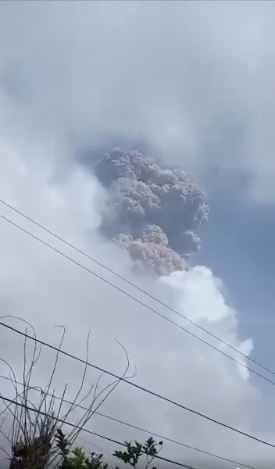
Merapi has been erupting since the start of the year, with the growth of two lava domes, block and ash falls and pyroclastic flows generated from partial collapses of the lave domes.  The current alert level is 3 (Siaga) and the aviation code is orange.  (Siaga translates as, using Google Translate, “Stand By” (There was a significant increase in volcanic activity. Eruption is most likely to occur and the area of potential eruption hazard is in the area of ​​Disaster-Prone Areas (KRB) II. The community is prohibited from carrying out activities in the KRB II area). The exclusion zone extends 5km from the summit).

Fig 1:  Merapi 2011 with Prambanan in the foreground, cropped from an image of Prambanan by Arabsalam, published under CC BY-SA 4.0.  Source: Prambanan Java243.  Prambanan is an 8th Century Hindu temple compound located approximately 17 kilometres (11 mi) northeast of the city of Yogyakarta and designated a UNECSO World Heritage Site.

Background

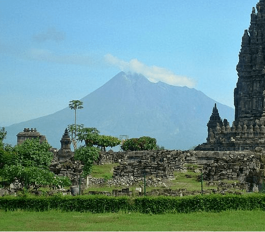
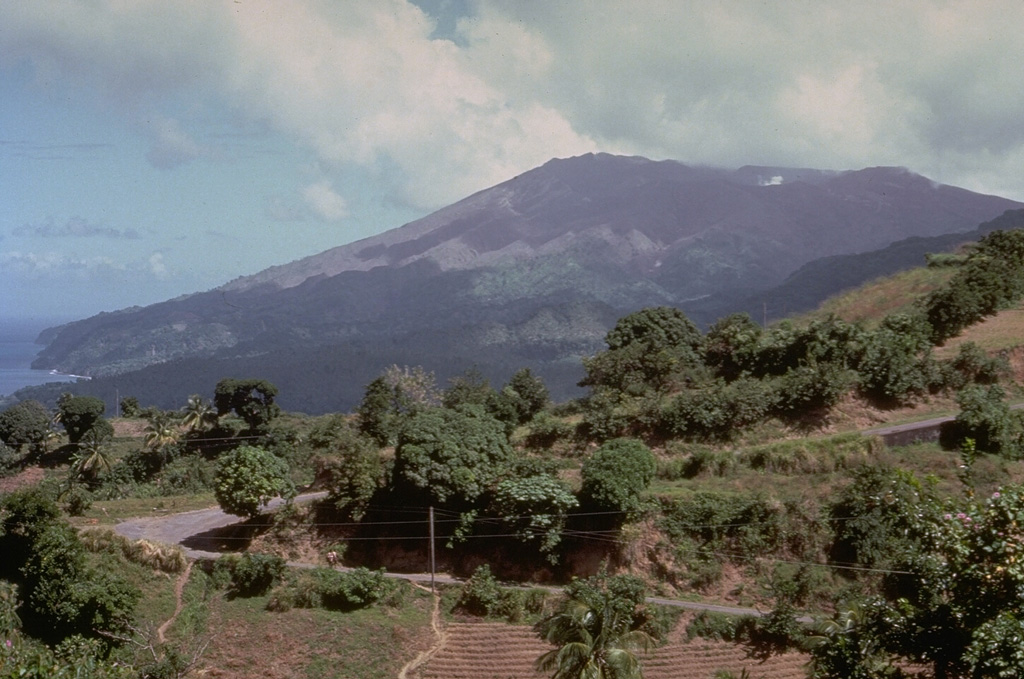
Merapi is a 2,968 m high stratovolcano located 25 km north of the city of Yogyakarta on the island of Java, Indonesia.  Volcanic activity at Merapi is believed to have started around 170,000 years ago.  Since then, activity alternated between effusive and explosive, the latter with lava domes and pyroclastic flows.  While her eruptions are comparatively modest (VEI 1 to 4), her proximity to a large metropolis means she has the potential to do a lot of damage, hence her status as a Decade Volcano. Over 4 million people live within 30 km of the volcano and over 24 million people live within 100 km of the volcano.

Yogyakarta, itself, is a densely populated city in the Special Region of Yogyakarta.  373,589 people live in the city (Census 2020) and over 4 million in the metropolitan area.  It is a sophisticated centre for Javanese fine arts, culture and education.  Yogyakarta has been home to the seat of power for the Medang Kingdom between the 8th and 10th century and Mataram Sultanate between 1587 and 1755.  Explosive eruptions from Merapi, which destroyed many Buddhist and Hindu temples built between 732 AD and 900 AD (and presumably caused other significant damage), may have been a factor in the migration of the Mataram Kingdom to East Java in 928 AD or 929 AD.

Tectonic Setting

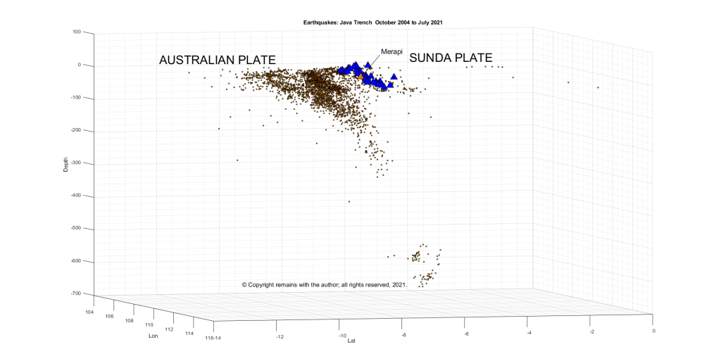
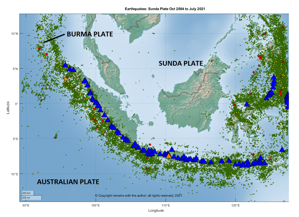
Volcanic activity on Java is driven by the northward subduction of the Australian Plate under the Sunda Plate at the Sunda Trench.   The western, southern and eastern boundaries of the Sunda Plate are tectonically very active. 

We downloaded earthquake data from EMSC for the period October 2004 to July 2021 between 14.04°S 86.16°E to 12.66°N 127.48°E to take a look. This area is larger than the area under discussion to make sure that subduction zone was captured.  The following images are from extracts of that data.

Fig 2: Subduction zone at the Java Trench section of the Sunda Trench.  Dots denote earthquakes, blue triangles, volcanoes.  The orange triangle is Merapi.  © Copyright remains with the author; all rights reserved, 2021.
Fig 3:  Tectonic setting – plot of earthquakes between October 2004 and July 2021 by the author.  Earthquakes clearly delineate the plate boundaries. Green dots denote earthquakes below 6.0 M, yellow dots, earthquakes between 6.0 M and 7.0 M, red dots, earthquakes between 7.0 M and 8.0 M, silver stars, earthquakes between 8.0 M and 9.0 M and orange star, earthquakes over 9.0 M.  Blue triangles denote volcanoes.  The orange triangle is Merapi.  © Copyright remains with the author; all rights reserved, 2021.

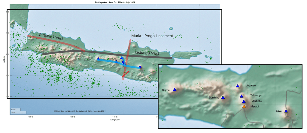
Merapi is located at the intersection of two volcanic lineaments:  the north – south trending Ungaran-Telomoyo-Merbabu-Merapi; and the east – west trending Lawu – Merapi – Sumbing – Sindoro – Slamet.  Ungaran-Telomoyo-Merbabu-Merapi is a double chain volcanic arc, with Ungaran as the back arc and Telomoyo-Merbabu-Merapi as the trench side volcanoes. Merapi is also bounded by two faults: the north – south Merapi – Merbabu fault and the Baribis – Semarang – Kendeng fault.  

Fig 4:  Earthquakes in Java from October 2004 to July 2021 plotted by the author.  Red and grey lines denote approximate locations of major faults, blue lines, volcanic lineaments, blue triangles, volcanoes and orange triangle, Merapi, black rectangle on the left is the area plotted.  © Copyright remains with the author; all rights reserved, 2021.

Growth of Gunung Merapi

Merapi formed in the late Pleistocene and Holocene in three stages: Proto-Merapi, Old Merapi and New Merapi.

Proto-Merapi emerged after 170 ka and includes Gunung Bibi, dated to 190 ± 60 ka, Gunung Turgo, 138 ± 3 ka, and Gunung Plawangan ,135 ± 3 ka.

Gunung Plawangan was home to a volcano observatory until the 1990s but was abandoned due to nuée ardentes from the current cone.

The summit of Gunung Turgo is home to sacred graves including that of Sheikh Jumadil Qubro, a direct descendant of the Islamic prophet, Muhammad.

Old Merapi started to grow around 30 ka, reaching a height slightly more than the current cone; growth ended with flank failures 4.8 ± 1.5 ka.  Collapse of the caldera with debris avalanche flows to the south and west left a Somma rim on the eastern slope. 

Gunung Batulawang and Gunung Kendil are part of Somma – Merapi. Gunung Batulawang is the highest peak of Old Merapi.  Lake Borobudur formed c 3,400 14C years BP. 

The latest Somma collapse was around 1,900 14C years BP. 

New Merapi, the current cone, grew soon after the growth of Old Merapi ended.  Partial edifice collapse of New Merapi may have occurred 1,130 ± 50 14C years BP. 

Gunung Selokopo Ngisor, Gunung Pusunglondon, Gunung Patukalapalap, Gunung Dengkeng, Gungung Selokopo Duwur and Gunung Gadjah Mungkur are hills which are thought to belong to New Merapi.

Volcanic Activity

Merapi’s lavas are typical for a subduction zone, being andesite / basaltic andesite, trachyandesite, basaltic trachyandesite with some basalt / picro basalt and trachybasalt / tephrite basanite.  Her lavas have evolved over time. Her early lavas were effusive basaltic.  The K2O content of the lava has increased over time; Old Merapi had lower K2O lavas than New Merapi and nearby Gunung Telomoyo and Gunung Merbabu. 

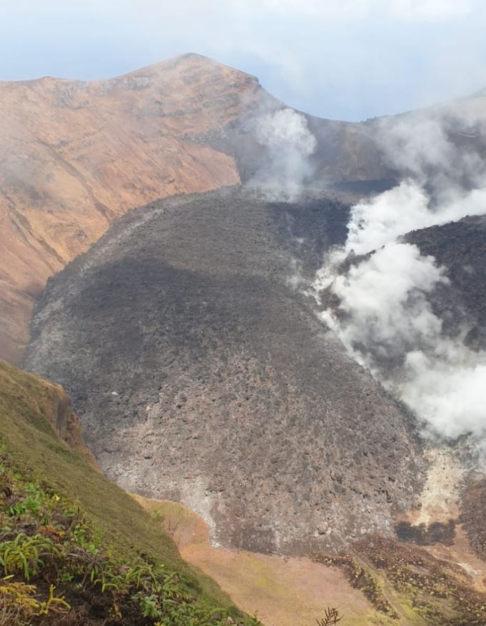
According to GVP, there have been 111 Holocene eruptions, ranging from VEI 1 to 4.  The most recent eruption, currently a VEI 1, started on 31 December 2020, with new lava domes extruded in January and February 2021, and, at the time of writing is ongoing.  The most recent VEI 4 was the devastating October 2010 to July 2012 eruption in which partial dome collapse caused pyroclastic flows that destroyed villages, led to the evacuation of more than 300,000 people and caused 386 fatalities; the ash plume reached 18km between 4-6 November; and, the largest pyroclastic flows occurred on 26 October 2010 and 5 November 2010 – the latter produced the widest pyroclastic flow seen in Indonesia for 100 years.  By mid-November, eruptive activity subsided, to be followed by lahars as the main hazard.

The 26 October eruption started 19 hours after tsunamis caused by earthquakes on the Sunda Trench swept away villages on the Mentawai Islands, killing 428 people and displacing thousands. The earthquakes were a 7.7 M, preceded by a 5.8 M and followed by aftershocks that included a 6.1 M and 6.2 M.  Whether or not the earthquakes triggered the eruption, itself, is open to debate; the volcano was ready to erupt. Since 2007 swarms of volcanic earthquakes had been occurring; deformation and gas emissions increased in September 2010; and, seismicity increased between 15 – 26 October, ramping up during 20 – 26 October.  The alert levels were raised to level 2 on 20 September 2010, level 3 on 21 October 2020 and level 4 on 25 October 2020.

A phreatic eruption on 11 May 2018, heralded a new phase of lava dome growth. In November 2020, evacuations were ordered due to decreasing stability of the lava dome. Eruptions commenced on 4 January 2021, leading to further evacuations in the Yogyakarta region.

Here’s hoping the current eruption remains a VEI 1.

The Armchair Volcanologist

©Copyright remains with the author; all rights reserved, 2021.

Sources and Further Reading:

Raw earthquake data, EMSC: https://www.emsc-csem.org/Earthquake/info.php

The Smithsonian Institution’s Global Volcanism Program (GVP): Merapi

Ralf Gertisser, Silvain J. Charbonnier, Jörg Keller, Xavier Quidelleur, “The geological evolution of Merapi volcano, Central Java, Indonesia”, Bulletin of Volcanology (2012) 74: 1213=1233. DOI: 10.1007/s00445-012-0591-3

Newhall, C. G., Bronto, S., Alloway, B., Banks, N. G., Bahar, I., del Marmol, M. A., Hadisantono, R. D., Holcomb, R. T., McGeehin, J., Miksic, J. N., Rubin, M., Sayudi, S. D., Sukhyar, R., Andreastuti, S., Tilling, R. I., Torley, R., Trimble, D., Wirakusumah, A. D., “10,000 Years of explosive eruptions of Merapi Volcano, Central Java: archaeological and modern implications”, Journal of Volcanology and Geothermal Research 100 (2000) 9 – 50. DOI:10.1016/S0377-0273(00)00132-3

Wikipedia:

Mount Merapi: Mount Merapi – Wikipedia

Yogyakarta: Yogyakarta – Wikipedia

Update on the eruptions at Fagradalsfjall and La Soufrière St Vincent, and status of Mount Pelée

Good Afternoon!

Fig 1: Image from Civil Protection / Webcam 11.05.2021

Fagradalsfjall

At the time of writing the eruption at Fagradalsfjall is not only continuing unabated but getting stronger.  After the opening of five new fissures, eruptive activity has focused on one crater, fissure 5. Lava now covers the Geldingadalur valley floor and threatens to engulf the first cones; lava has been flowing steadily into Meradalir since 24 April 2021.

Eruptive activity changed from continuous fountaining with effusive lava flows to periodic jetting after midnight on 2 May 2021. The change is thought to be due to degassing of the magma in the upper part of the eruption channel where a small chamber may have formed.  Each jet is now accompanied by strong gas emissions.  Lava flow, itself, is mostly being carried in lava channels under the crater rim, rather than ejected in the current jets so periodic jetting has not adversely impacted the output.

The onset of jetting can be seen in the tremor plots from local stations. We have included KRI because, being further away, we can see more of the lower frequency lines.

Fig 2: Tremor plots for KRI and MER showing the onset of jetting on 02 May 2021. Source: IMO
Fig 3: Unrest seen on seismometers near the eruption sites with pulses in volcanic activity from midnight on 2 May 2021.  Source: IMO
Fig 4: This image shows the unrest on days 8-9. May. Source:  IMO

Some stats as at 10 May 2021 (Source: Institute of Earth Sciences (hi.is))

  • Area of the Geldingadalsgos lava field: 1.78 Km2 (1.41Km2, 03 May 2021)
  • Volume of erupted lava: 30.7 million m3 (23.0 million m3, 03 May 2021)
  • Lava discharge rate: 12.9m3/s, (7.5m3/s, 03 May 2021)
  • Mg0: varies from 8.5 to 9.8
  • K20/Ti202 ratio: increasing from 0.1 to 0.3

In the first two weeks of the eruption lava flow decreased steadily from 7-8m3/s to 4-5m3/s.  In the second two weeks, five new fissures opened with lava flow varying between 5 – 8m3/s.  In the two weeks to 3 May 2021, one crater dominated with lava flow increasing.  In the week to 10 May 2021, there has been a large increase in the output of lava to 12.9m3/s; the lava field now covers an area of 1.78km2 with a volume of 30.7 million m3.  It is thought that the increase in output reflects changes in the lava channel from the mantle to the surface; it has widened over time.

Changes in chemical composition may mean that materials are mixing in the upper mantle before ascent or there is less partial mantle melt in the magma.  If the latter, the eruption will end when the mantle source is sufficiently reduced.

Geldingadalsgos is still a toddler compared to Holuhraun; Geldingadalsgos’ eruption rate is 5% – 10% of the average eruption rate at Holuhraun between September 2014 and February 2015. Let’s hope it stays that way as it is a lot closer to residential areas.

La Soufrière St. Vincent

The alert status was lowered to orange after a period of relative quiescence on 6 May 2021; only a few long period events and volcano-tectonic earthquakes are occurring each day.  People are allowed back into the orange zone but the red zone remains an exclusion zone.

The last explosive event was on 22 April 2021.  However, a possible lava spine was spotted on photos on 27 April 2021.  Tephra fills the crater, increasing the risk of pyroclastic flows should eruptive activity pick up again.  In the meantime, lahars are the main hazard.

Mount Pelée

Mount Pelée remains on alert level yellow.  Volcano tectonic events are occurring and seismic activity remains at above baseline level.  An area of brown and dead vegetation was confirmed on 8 February 2021 caused by diffuse CO2 emissions; the vegetation has not recovered.   The volcano is slowly reawakening.

Armchair Volcanologist

© Copyright remains with the author; all rights reserved, 2021.

Sources and Further Reading:

In the text and:

Iceland

Icelandic Met Office: https://en.vedur.is/ (English site)

Icelandic Met Office: https:// vedur.is/ (Icelandic site)

Reykjavik Grapevine: https://grapevine.is/

Department of Civil Protection and Emergency Management | Almannavarnir

La Soufrière St. Vincent

St Vincent and the Grenadines:  https://news784.com/

Barbados: https://www.nationnews.com/

Mt Pelée

Observatoire volcanologique et sismologique de Martinique (OVSM – IPGP): http://www.ipgp.fr/fr/ovsm/observatoire-volcanologique-sismologique-de-martinique-ovsm-ipgp

Alert Level for La Soufrière St. Vincent Raised to Red: Eruption in progress

Update 10.04.2021

At the time of writing, there have been several explosive eruptions now from La Soufrière St. Vincent.  The island has experienced extensive ashfall.  The emergency evacuation has extended to the orange zone.  Ash has reached 51,000 feet (38,000 feet, latest VAA) according to the volcanic ash alerts and the ash cloud has drifted over Barbados.

Fig 3: Ash plume from the first explosion.  Photo from NEMO

Most of the new lava dome has been destroyed and the 1979 lava dome has suffered some damage.  Removal of the rock has given magma a more open pathway.  The eruption is expected to be larger than the 1979 eruption and to continue for some time; explosions are expected to be the same or greater magnitude. As far as we know, there have not been any pyroclastic flows but they are expected. 

More than 3,000 people are in emergency accommodation and others are staying with friends or relatives.   Saint Lucia, Grenada, Antigua and Barbados have offered to take refugees.  Carnival Cruise Lines and the Royal Caribbean Group will send cruise ships to transport people to other islands. Venezuela has sent humanitarian aid and risk experts.

The north and west of Barbados have been hard hit by ash; the skies turned dark and ash is falling.  Residents have been advised to stay indoors, except for essentials or a medical emergency.  Beaches, parks and fish markets are closed for the time being. People with respiratory disorders have been advised to have their medication with them at all time.  The airport and airspace is closed at the moment.

Latest VAA forecast:

Fig 4: Volcanic ash forecast from Washington VAAC Volcanic Ash Advisory (noaa.gov). The volcano is coloured in red and Barbados is in the red circle.

Thoughts with everyone affected.

Sources:

NEMO St. Vincent: ‪#‎lasoufriereeruption2021

Hazard zones, St Vincent: Home (nemo.gov.vc)

Washington VAAC: Volcanic Ash Advisory (noaa.gov),

News 784: NEMO: Explosive Eruptions May Continue Over The Next Few Days And Weeks • News784

Barbados Government Information Service: GIS News | GIS (gisbarbados.gov.bb)

Nation News, Barbados: Volcano ash turns northern skies dark – NationNews Barbados — nationnews.com

Update 16:51, 09.04.2021

An explosive eruption started at La Soufrière St. Vincent around 12:40 pm GMT today, sending an ash column 8 km into the sky. The ash cloud reached 20,000 feet, drifting eastwards. Ashfall has been observed at Argyle International Airport.

Scientists warn that further larger eruptions are possible.

The evacuation from the red zone (northern end of the island) is still in progress at the time of writing.

Source: NEMO St. Vincent and the Grenadines | Facebook

Original Post: 12:46, 09.4.2021

Good Afternoon!

Increasing gas emissions and seismic activity, including long period events, indicate that new magma is ascending at La Soufrière St. Vincent and an eruption could be imminent.  An immediate evacuation order was given earlier today (c.1:00 am GMT) for the red zone in the north of the island, impacting 16,000 people.

Fig 1: La Soufrière St. Vincent, seen here from the south. Photo by Richard Fiske, 1980 (Smithsonian Institution).

The new lava dome has been steadily growing since it emerged in December 2020.  The emission of gas and stream from the centre of the dome and its border with the 1979 dome increased on 8 April 2021.  A preliminary VAA noted that a well-defined hotspot was visible in the SW.   Incandescence from the dome was visible in St Lucia.

A swarm of volcano-tectonic earthquakes started on 6 April 2021 beneath the volcano at a depth of around 6 km.  Long period earthquakes have also been observed, indicating that new magma is ascending.

Fig 2: New lava dome on 19 March 2021 between the 1979 lava dome on the right of the image and the crater wall on the left.  Photo NEMO.

Background

Volcanic activity, here, is driven by the subduction of the South American Plate under the Caribbean Plate.

La Soufrière St. Vincent is a 1,234m high stratovolcano located in the north of St. Vincent Island, which rides on the Caribbean Plate. She is the youngest volcano on the island.  At the summit there is a 1.6 km wide crater with a younger crater formed in the 1812 eruption, located in a 2.2 km wide Somma crater.  Her lavas are typical of a subduction zone setting: andesite / basaltic andesite and basalt / picro-basalt.

GVP records 23 Holocene eruptions, the largest of which were VEI 4s in 1812 and 1902.  The 1902 eruption devastated much of the northern end of the island.  A lava dome was extruded in the eruption of 1971, which was destroyed to be replaced by a new dome in 1979 in a series of explosive eruptions.  The 1902 eruption devastated much of the northern end of the island. Pyroclastic flows from eruptions in 1812, 1902, and 1979 reached the coast.

For advice and the status of La Soufrière St. Vincent, please consult NEMO or follow their Face Book page (links below).

Thoughts with those impacted by the evacuation and eruption.

The Armchair Volcanologist

© Copyright remains with the author; all rights reserved, 2021.

Sources and Further Reading

National Emergency Management Organisation (NEMO): Home (nemo.gov.vc) and https://www.facebook.com/nemosvg/

Washington VAAC: Current Volcanic Ash Advisories

The Smithsonian Institution’s Global Volcanism Program (GVP): https://volcano.si.edu/

“Mt. Pelée, La Soufrière St. Vincent and a Quick Tour of the Plates Surrounding the Caribbean”: https://thearmchairvolcanologist.com/2021/02/01/mt-pelee-soufriere-st-vincent-and-a-quick-tour-round-the-plates-surrounding-the-caribbean-plate/