Sadly the death toll from Mount Semeru now stands at c.40 as of noon today (local time). Over 100 have been injured.
The lava dome collapsed from 1st to 6th December 2021 generating both lava and pyroclastic flows. The largest dome collapse occurred around 14:47 on 4th December 2021 to be followed by pyroclastic flows from 15:10, causing the fatalities. Rescue efforts have been hampered by later eruptive activity.
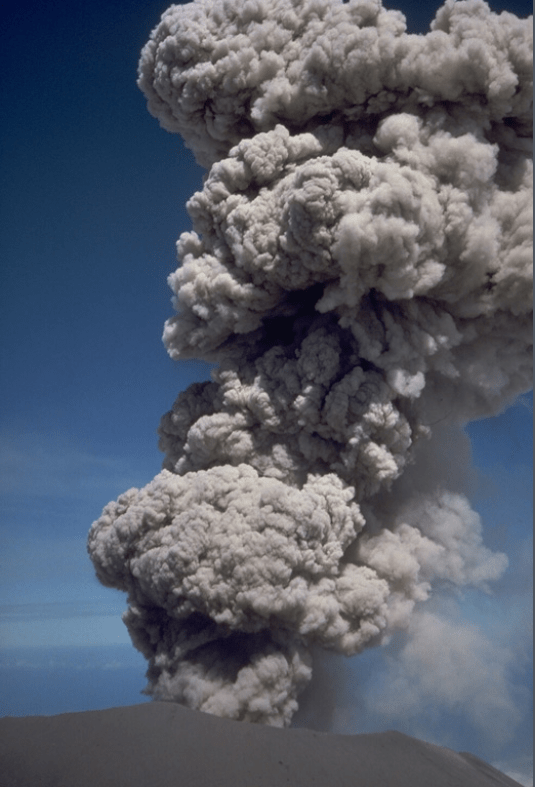
Fig 1: Image from 1985 eruption of Semeru, cropped from a photo by Tom Casadevall, 1985 (U.S. Geological Survey). Source: GVP
Sadly, 13 people have been killed, 7 missing and c. 100 injured, at the time of writing, following the collapse of the lava dome on Mount Semeru on 4 December 2021. Ash rose to a height of 50,000 feet, covering 11 villages. Flows of hot gas and lava travelled 800m at least twice on Saturday, reaching a nearby river. Two bridges were destroyed, including one connecting Lumajang to Malang. 900 people have been evacuated. 10 trapped in mines were rescued. Heavy rain and a thunderstorm had led to destabilisation of the lava dome. The volcano had been on alert level II (Waspada).
Mount Semeru is 3,657m high a stratovolcano with pyroclastic cones and fissure vents. Lake-filled maars follow a N-S trend cutting through the summit. She is located in the Lumajang district, East Java. Java lies above the subduction zone where the Indo-Australian Plate subducts under Sunda Plate . Her lavas are Andesite / Basaltic Andesite and Basalt / Picro-Basalt. Over 1m people live within 30km of the volcano.
GVP records 65 Holocene eruptions since 1818, which range from VEI 1 to VEI 3.
This update is based on news reported from St Vincent and The Grenadines and Barbados up to 14 April 2021 (edited 16.04.2021).
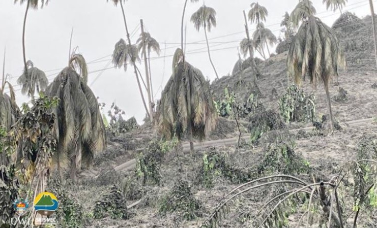
Fig 1: Ash covering vegetation in the red zone. Image by Prof. Richard Robertson, UWI-SRC.
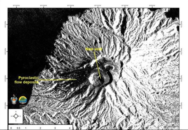
A new crater and vent were observed by satellites on 12 April 2021. Both lava domes have been destroyed.
Fig 2: Satellite image from the European Space Agency of the new crater and vent. The new vent and pyroclastic flows have been marked by UWI-SRC.
The North East of the island has been devastated; the agricultural area has been described by the Deputy Prime Minister of St Vincent & the Grenadines, Montgomery Daniel, as non-existent; trees and farms have been destroyed – only tree stumps are standing. He likens the damage to that caused by Hurricane Thomas. The crops lost include bananas, breadfruit, coconuts, mangos, soursop, plantains, arrowroot, dasheen and ginger and yams. The island’s economy is heavily dependent on the export of bananas and tourism.
Pyroclastic flows caused by ash columns collapse occurred on 13 April 2021, hitting the eastern side of the volcano. Areas at risk are Georgetown, Sandy Bay, Owia, Fancy and other settlements. Lahars have been reported by Sandy Bay.
Pyroclastic flows on 12 April were observed on the western and southern flanks of the volcano, reaching the sea at Morne Ronde, Larikai and Trois Lopues Bay.
Water supplies were contaminated by ashfall. The water supply has been restored to most of the island excluding the red zone (Owia, Sandy Bay, Fancy and Heritage), having cleaned ash out of the supply systems. Bottled water has been supplied from Barbados (although Barbados is suffering from ashfall as well). Several other nations have sent water. Water testing kits have been supplied by the World Health Organisation and Pan American Health Organisation.
Loss of power supplies were reported on 11 April 2021. No mention has been made of their status since. But it can be assumed that every effort would have been made to restore them.
Venezuela is providing humanitarian support. Guyana, Grenada and others have also sent supplies. Financial aid has been sent by other Caribbean islands, the UK (among others), the UN and the World Bank.
Barbados continues to get ashfall. The opening of schools has been delayed to allow for a cleaning up operation (ash got in via ventilators and windows). Ash has impacted water supplies in the north.
Explosions were occurring roughly 14 hours apart, with swarms of small long period earthquakes in between. It had been hoped that the explosive activity had waned for a while after a longer gap and that the continuing long period and hybrid earthquakes signified growth of a new lava dome, but another explosion occurred at 06:15 this morning (16.04.2021). SO2 levels indicate that fresh magma is arriving from a deeper source. The eruption is currently categorised as a VEI 4. It is expected to continue for some time, following the pattern of the 1902 eruption.
The United Nations have stated that this humanitarian crisis could go on for some time and that it may extend to other nearby islands.
At the time of writing, there have been several explosive eruptions now from La Soufrière St. Vincent. The island has experienced extensive ashfall. The emergency evacuation has extended to the orange zone. Ash has reached 51,000 feet (38,000 feet, latest VAA) according to the volcanic ash alerts and the ash cloud has drifted over Barbados.
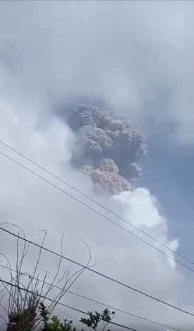
Fig 3: Ash plume from the first explosion. Photo from NEMO
Most of the new lava dome has been destroyed and the 1979 lava dome has suffered some damage. Removal of the rock has given magma a more open pathway. The eruption is expected to be larger than the 1979 eruption and to continue for some time; explosions are expected to be the same or greater magnitude. As far as we know, there have not been any pyroclastic flows but they are expected.
More than 3,000 people are in emergency accommodation and others are staying with friends or relatives. Saint Lucia, Grenada, Antigua and Barbados have offered to take refugees. Carnival Cruise Lines and the Royal Caribbean Group will send cruise ships to transport people to other islands. Venezuela has sent humanitarian aid and risk experts.
The north and west of Barbados have been hard hit by ash; the skies turned dark and ash is falling. Residents have been advised to stay indoors, except for essentials or a medical emergency. Beaches, parks and fish markets are closed for the time being. People with respiratory disorders have been advised to have their medication with them at all time. The airport and airspace is closed at the moment.
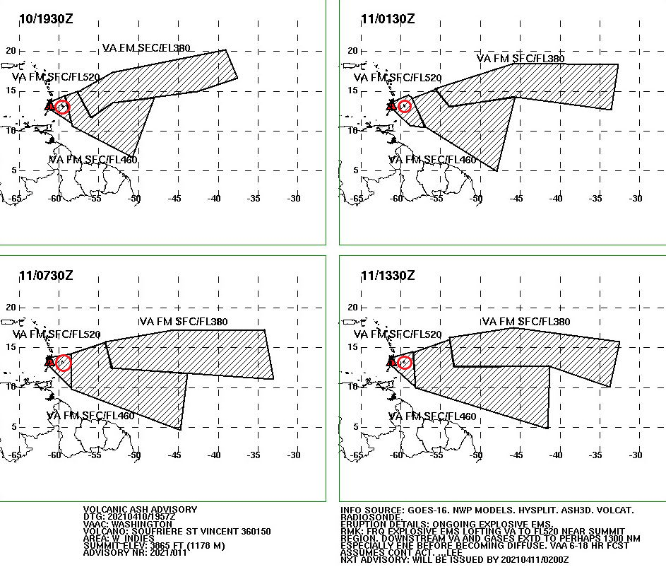
Latest VAA forecast:
Fig 4: Volcanic ash forecast from Washington VAAC Volcanic Ash Advisory (noaa.gov). The volcano is coloured in red and Barbados is in the red circle.
An explosive eruption started at La Soufrière St. Vincent around 12:40 pm GMT today, sending an ash column 8 km into the sky. The ash cloud reached 20,000 feet, drifting eastwards. Ashfall has been observed at Argyle International Airport.
Scientists warn that further larger eruptions are possible.
The evacuation from the red zone (northern end of the island) is still in progress at the time of writing.
Increasing gas emissions and seismic activity, including long period events, indicate that new magma is ascending at La Soufrière St. Vincent and an eruption could be imminent. An immediate evacuation order was given earlier today (c.1:00 am GMT) for the red zone in the north of the island, impacting 16,000 people.
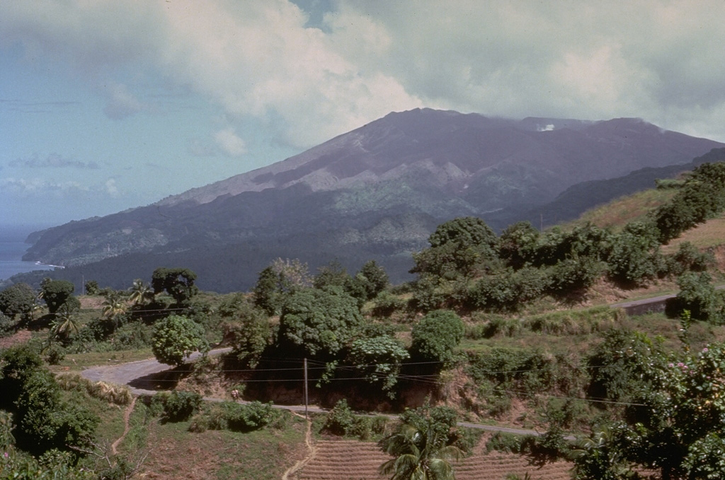
Fig 1: La Soufrière St. Vincent, seen here from the south. Photo by Richard Fiske, 1980 (Smithsonian Institution).
The new lava dome has been steadily growing since it emerged in December 2020. The emission of gas and stream from the centre of the dome and its border with the 1979 dome increased on 8 April 2021. A preliminary VAA noted that a well-defined hotspot was visible in the SW. Incandescence from the dome was visible in St Lucia.
A swarm of volcano-tectonic earthquakes started on 6 April 2021 beneath the volcano at a depth of around 6 km. Long period earthquakes have also been observed, indicating that new magma is ascending.
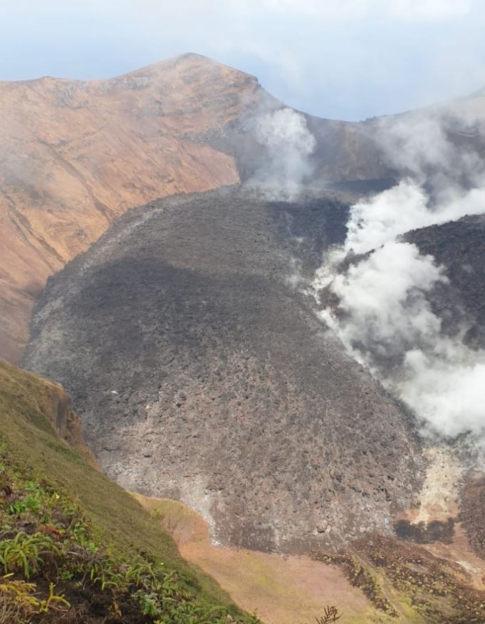
Fig 2: New lava dome on 19 March 2021 between the 1979 lava dome on the right of the image and the crater wall on the left. Photo NEMO.
Background
Volcanic activity, here, is driven by the subduction of the South American Plate under the Caribbean Plate.
La Soufrière St. Vincent is a 1,234m high stratovolcano located in the north of St. Vincent Island, which rides on the Caribbean Plate. She is the youngest volcano on the island. At the summit there is a 1.6 km wide crater with a younger crater formed in the 1812 eruption, located in a 2.2 km wide Somma crater. Her lavas are typical of a subduction zone setting: andesite / basaltic andesite and basalt / picro-basalt.
GVP records 23 Holocene eruptions, the largest of which were VEI 4s in 1812 and 1902. The 1902 eruption devastated much of the northern end of the island. A lava dome was extruded in the eruption of 1971, which was destroyed to be replaced by a new dome in 1979 in a series of explosive eruptions. The 1902 eruption devastated much of the northern end of the island. Pyroclastic flows from eruptions in 1812, 1902, and 1979 reached the coast.
For advice and the status of La Soufrière St. Vincent, please consult NEMO or follow their Face Book page (links below).
Thoughts with those impacted by the evacuation and eruption.
We are looking again at the volcano basics, this time the hazards posed by volcanoes. This is not intended to put you off visiting a volcano; understanding the hazards is the first step towards mitigating volcanic risk.
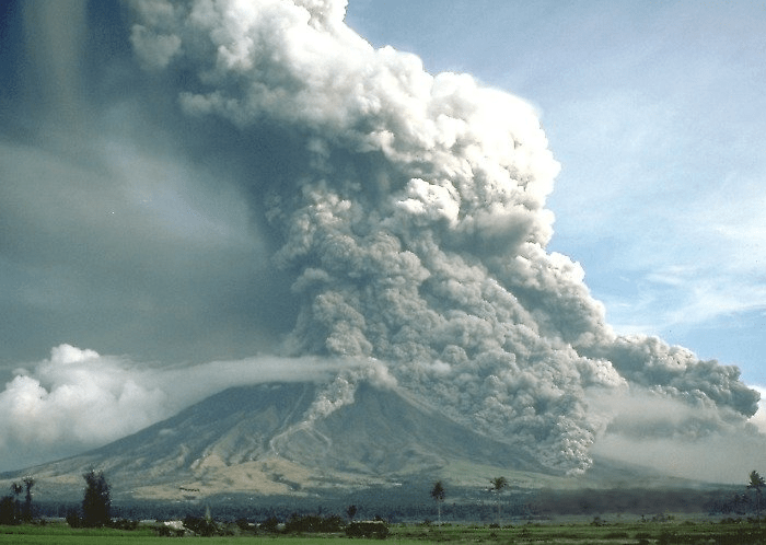
Fig 1: Pyroclastic flows at Mayan, 1984, Philippines by C. G. Newhall, Public Domain
Visiting a volcano
A quick word about visiting a volcano before we get into volcanic hazards.
It is usually possible to view an erupting volcano from a safe distance if you follow local official advice. Where there is an exclusion zone in place, the local authorities consider it too unsafe for the general public to go into that zone. Your insurance company and local rescue teams would probably take a very dim view of any accidents arising should you stray into the zone and need rescuing.
If you want to visit a volcano, do your research, take advice and have an enjoyable trip.
Volcanic risk mitigation
The purpose of volcanic risk mitigation is to reduce the losses from a volcanic eruption or other volcanic hazard. This involves understanding the hazards posed by the volcano, the losses that would be incurred should an event occur and putting appropriate measures in place, where possible.
Volcanic hazards
This is a list and brief description of the major volcanic hazards, both when the volcano is in repose and when it is erupting.
Volcano not erupting
When a volcano is not erupting the hazards are pretty much the same as for any mountain: altitude, weather, avalanche, rock fall, getting lost in unfamiliar terrain, not being properly prepared, and/or not looking where you are going while taking that selfie / photo.
There may be the additional hazards from gas emissions, hot springs or fumaroles: for example, carbon dioxide is an invisible odourless gas that can accumulate in depressions in the ground or caves, replacing the oxygen in the air leading to asphyxiation; hot springs can cause chemical and heat burns; fumaroles emit gases.
Volcano erupting
The main additional hazards from an erupting volcano are: blast wave (directed blast), eruption clouds, tephra, pyroclastic flows, lava flows, lava domes, debris avalanche flows, lahars, jökulhlaups, gas emissions, earthquakes, caldera formation and tsunamis.
Blast wave:
Explosive eruptions triggered by a sudden release in pressure can generate supersonic blast waves (directed blasts). These blasts can flatten trees, destroy property and kill (directly or via debris hurled by the wave). If the gases and ash released in the explosion are hot, they sear everything in their path. An example is the lateral blast wave produced by Mount St Helens at the start of the May 1980 eruption.
Eruption clouds:
These are the clouds of ash, gases and rocks propelled by the volcano into the atmosphere; the cloud rises through kinetic energy from the eruption and heat. Before the advent of aviation only the larger ash clouds posed a serious threat. Ash clouds may reach heights from hundreds of metres to tens of kilometres. If the ash cloud reaches the stratosphere it can have regional and global impacts on climate; ash filters out sunlight, cooling the air. Examples of climate impacting eruption clouds are Krakatau, 1883, and Tambora, 1815.
Ash, especially ash with a high silica content, is also bad for aircraft. Flying through an eruption cloud at speed is akin to flying through a large sand blaster. Ash abrades the outer surface of the aircraft, including the windshields and lacerates vulnerable parts. Engine heat also melts the ash, coating fuel nozzles and turbine blade with glass, which may stop the engines in seconds. An eruption as small as a VEI 3, is enough to put an aircraft at risk. Examples of aircraft in trouble are the VEI 4 eruption of Galungung, 1982 and VEI 3 of Redoubt, 1989. A BA flight encountered the eruption cloud from Galungung 150 km away from the volcano; all the engines cut out, were successfully restarted 2,000 m from the sea, after falling 9,000 m, only for the experience to be repeated when the plane flew back into the cloud (the plane later landed successfully in Java, despite having an abraded opaque windscreen); a Singapore Airlines flight was only able to recover two engines from the loss of all four after flying through the same cloud two weeks later. A KLM flight lost all four engines in the Redoubt ash cloud and got uncomfortably close to the Alaskan mountains before being able to recover.
Tephra:
What goes up, must come down. Tephra is the ash and rock that falls out of the eruption cloud due to gravity. It is densest nearest to the volcanic vent; it can be dense enough to cut out all light by filtering out starlight, moonlight and sunlight; it may also cut the electricity supply, block roads and hamper rescue attempts.
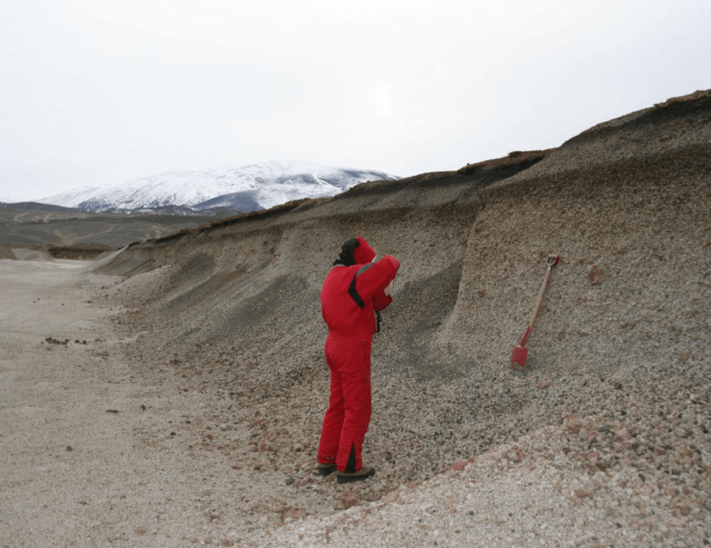
Fig 2: Light-coloured tephra deposit from one of Hekla’s largest explosive eruptions, H-3. The total thickness is of the order of several meters. Photographer: Guðrún Sverrisdóttir, Photo 5 of 5. Retrieved from Icelandic Volcanoes
The weight of accumulated tephra on buildings may cause them to collapse. If the tephra is combined with water, it may turn to concrete and be very difficult to remove.
Accumulation of tephra on the ground may cover vegetation, cutting off air and water to the plants: a layer as thin as 2.5 cm is enough to kill some plants, vegetation recovers within a year; a covering of 15 cm or more is enough to kill vegetation and sterilise the soil from which it takes decades to recover.
Tephra may also be rich in chemicals that are toxic to plants and the livestock that feed on them and contaminate the water supply. Fluorosis from ash is a common cause of death in livestock and people. Some minerals in tephra are also carcinogenic.
There is no shortage of examples of eruptions where tephra has caused loss of life; here are three: Pinatubo, 1991, Vesuvius, 79 AD, and Tambora, 1815.
Pyroclastic flows:
These are big killers. You cannot outrun a pyroclastic flow so unless you are right on the edge of a cold flow, or in an air-tight robust building, your chance of survival is zero. Pyroclastic flows are fast-moving surges of gases, ash and rocks propelled by gravity that flow down the sides of the volcano at speeds of up to 200 km per hour; heavy ash and rocks form a basal surge, whereas lighter ash may form phoenix clouds, propelled upwards by heat and turbulence. Small flows may travel up to 20 km and larger ones more than 100 km from the vent. Pyroclastic flows are generated by collapse of the eruption column or by lava domes (collapse of the dome or detonation by pressurised gas).
Pyroclastic flows deposit large volumes of ash and rocks; lumps of lava may be the size of a vehicle. If the flow is hot, the ash and rocks may be welded together as ignimbrite. Hot flows will ignite anything that is flammable. The area covered by the debris depends on the size of the eruption, a very large one may cover an area the size of Switzerland.
Again, there is no shortage of examples of pyroclastic flows, in addition to the three eruptions noted above, there is the VEI 4 1902 eruption of Mount Pelée, Martinique, in which two pyroclastic surges caused by dome collapse wiped out the capital St Pierre killing 30,000 and leaving 50,000 homeless; a third pyroclastic flow killed 2,000 in Morne Rouge.
Lava:
Lava flows are the lava which flows down a volcano or across open ground. Most lava is viscous and can be outrun; hazards tend to be damage to property, farm land, power supplies and communication lines. There are rare instances where lava flows have killed, such as Nyiragongo in 1977, when a fissure emptied the lava lake, producing basaltic lava flows with speeds of 30km per hour; where observers getting too close were casualties chunks of lava breaking off the flow or from the explosions where hot lava met water or ice; or where lava flows have cut off escape routes.
Lava domes are formed when more viscous magma builds up as a dome rather than flows. They tend to have a solid surface and may have spines of solid lava pushed up by magma from the centre of the dome. Lava domes may collapse under gravity causing block and ashflow eruptions or there may be a directed blast where a crack or collapse releases pressure. Examples where lava domes have claimed lives are Mount Pelée, 1902, Mount Unzen, 1991, Merapi, 1930, Mount St Helens, 1980 (cryptodome).
Debris Avalanche Flows & Lahars:
Volcanoes are made up of layers of loose ash and lava so are not very stable. They may suffer partial edifice collapse as a result of gravity, erosion or from the pressures generated during an eruption. The collapse causes debris avalanche flows – a fast moving, gravity driven currents of rocks, water and other materials.
Mount St Helens is an example of the debris avalanche flow triggered by magma: a dacite cryptodome destabilised the northern slope; a small earthquake caused the bulge to fail, its collapsing released superheated steam, resulting in the catastrophic eruption. Bandai volcano in Japan suffered failure of the northern flank set off by a small phreatic eruption in 1888; the avalanche had a volume of 1.5km3 and killed 461 people. Unzen in 1792 suffered sector collapse with no eruptive activity; the edifice failed under gravity alone.
A lahar is a water saturated debris avalanche flow (mudflow). Lahars may be triggered by heavy rainfall typical of the tropics or by the rain storms generated by an eruption. Rain washes loose ash and rocks into river valleys or gullies where they mix to torrential mud flows. Lahars can move at speeds of 90 km per hour. Mudflows, plus debris picked up, form torrents which destroy property and kill those caught in their path. A famous example of a catastrophic lahar is the destruction of the town of Armero in 1985 from a series of lahars resulting from pyroclastic flows 50 km away at the summit melting snow in a VEI 3 eruption of Nevado del Ruiz; most of the population of 28,700 were buried in several metres of mud.
Jökulhlaups:
These are glacial outburst floods caused by the melting of glacier ice by heat from magma near the surface or during an eruption. The water may accumulate under the ice in lakes, if its exit is blocked by ice, to be released as a flood when the ice dam breaks or floats. Jökulhlaups carry debris from ash, boulders and ice bergs from the glacier.
The term is Icelandic and here we can find many examples. One is the 1996 jökulhlaup from Grímsvötn with a volume of 3.5 km3, which reached a peak discharge of 45,000 cubic metres per second. Most of the damage was to roads, bridges and power supplies; not many people lived in the vicinity. Flood deposits covered 750 km2 and extended the coastline out by 800m.
Volcanic Gases:
Volcanoes emit gases (volatiles) both when erupting and not. The volatiles include sulphur dioxide, steam, carbon dioxide, hydrogen fluoride, hydrogen chloride, hydrogen sulphide and carbon monoxide; they may also include toxic compounds of arsenic, bismuth, cadmium, copper, lead, mercury, thallium and zinc. Volatiles can tell us much about the lavas: unevolved magmas (mid ocean ridge basalts) tend to contain less water than arc basalts and rhyolites. However, here we are concerned with the hazards posed by volcanic volatiles.
Volcanic emissions damage vegetation, mostly by the acidic effects on soil and foliage, reducing crop yields or stripping vegetation. Acidic gases may damage skin and irritate eyes and lungs. Hydrogen sulphide, like carbon dioxide, can accumulate in volcanic or geothermal areas, causing fatalities from neural, respiratory and cardiovascular damage or by asphyxiation. One such tragedy occurred at Lake Nyos on 21 August 1986 in Cameroon when a cloud of carbon dioxide released from the lake flowed down the volcano, asphyxiating the 1,700 people plus pets, livestock and wild animals in its path.
Earthquakes:
Volcanic activity rarely produces large earthquakes (over 6.0 M); the ground motion required to accommodate magma movement is relatively small. However, magma movement generates swarms of earthquakes which can run into the thousands. The accumulated shaking may damage property, weakening it to be more vulnerable to the effects of the eruption which may ensue.
Caldera formation:
I have not seen this mentioned as a specific hazard in its own right in my text books, probably because much of the hazard is covered by other factors, such as: the eruption cloud, tephra, lava flows, tsunamis and earthquakes, which may be considerable in a caldera-forming eruption.
A caldera is formed when the roof of the magma chamber sinks while its contents are being evacuated. In addition to the eruptive products, this may result in loss of land as we saw with Krakatau. The depression may fill rapidly with water (sea water or fresh water). Land loss is likely to be permanent resulting in loss of property, businesses, flora and fauna and anything else left on that land.
Tsunamis:
These are big killers. Volcanic tsunamis are generated when a large volume of sea water is displaced by ash deposited by a collapsing eruption columns, pyroclastic flows and edifice failure. Tsunamis may travel a long way, devastating shore-lines. Examples are Krakatau, 1883 and Tambora, 1815.
So why live near a volcano?
If volcanoes are such a threat, why do people live near them, or even on their slopes (assuming that they know that the beautiful wooded mountain is a volcano)? We’ll look at the reasons in more detail later, but in summary they are that large eruptions are not that frequent (the volcano may be in repose for decades / centuries); volcanic ash contains a lot of nutrients which lead to fertile soils, good for crops and livestock; the scenery is often unusual or attractive leading to tourism; and, if you were born or raised in the area, you may accept the risk.
We will look at volcanic risk mitigation over the coming weeks.
Krakatau’s VEI 6 eruption of 1883 is the next in our series of famous eruptions. We have also included a summary of birth of Anak Krakatau from the caldera, and the December 2018 cone collapse and resulting tsunami.
The 1883 eruption is not only famous for the catastrophic destruction of Krakatau Island, pyroclastic flows, global cooling, devastating tsunamis and a death toll of between 36,164 to 120,000 people, but it is also the first major eruption to have been reported globally by telegraph. A typo in the telegraph led to the west calling the volcano Krakatoa.
The 2018 eruption, cone collapse and tsunami are well-documented by various sources. Our go-to resource here was primarily GVP.
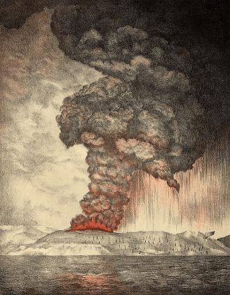
Fig 1: Lithograph: Parker & Coward, Britain. 1888. Public Domain
Geological Setting
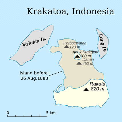
Katakatau lies to the west of the Sunda Strait between Sumatra and Java. It is the site of a much larger 7 km wide caldera which may have been formed during eruptions in 416 AD or 535 AD. The edges of the caldera are marked by Verlaten and Lang Islands.
Before the 1883 eruption, Krakatau was a 9 km long verdant, wooded island formed from three volcanoes, Rakata, Danan and Perbuwatan in the caldera. Another small island in the group was Polish Hat. The islands were uninhabited but used by local fishermen, woodcutters and the Dutch and British navies.
Fig 2: Map by ChrisDHDR showing Krakatau Island before the eruption and the site of Anak Krakatau, Public Domain
Eruptive History
GVP records 56 known Holocene eruptive periods for Krakatau, of which only 10 precede the 1883 eruption. The evidence for the 10 is historical observations from 250 AD to 1684, so perhaps earlier activity has been lost under the debris from more recent events. Activity after 1883 relates to building of Anak Krakatau.
The 535 AD eruption of Krakatau may have caused the volcanic aerosol veil that dimmed the Sun (filtered out sunlight) for eighteen months, causing crop failures, cooling and hiding Canopus, a bright star used by Chinese astronomers to mark the seasons – more likely if the eruption was a large caldera forming event. The other contender (preferred by some) is the 408 AD – 536 AD Tierra Blanca Joven eruption of Ilopango, El Salvador. On the other hand, why exclude one? Both may have contributed in some way.
Krakatau’s lavas are typical of a subduction zone: andesite, basaltic andesite, dacite, trachyte and trachydacite; and, also basalt and picro basalt. The last mentioned indicates that there may be more rapid magma ascent through extensional faulting in the area.
The 1883 Eruption: 100 Days of Activity
The Intro
The only known precursors to the 1883 eruptions are a large earthquake on 1 September 1880 followed by a period of increasing seismicity. Unfortunately, the area is seismically very active, being near the convergent margin between the Sunda Plate and the descending Indo-Australian Plate so, without modern instrumentation, there was insufficient information to interpret escalating events.
On the 20 May 1883 eruptive activity started at the Perbuwatan crater with series of loud explosions audible 150 km away. Light ashfall covered the area and a column of steam was visible. Activity continued for a few days then calmed down enough for a party to charter a boat to the island on 27 May 1883; they were the only witnesses to the Perbuwatan crater, then about 1 km in diameter, 50 m deep, with a small pit generating a steam column and small explosions every 5 to 10 minutes. By the end of June 1883, the summit of Perbuwatan had been destroyed and a second eruption column was visible at the centre of the island.
Captain Ferzenaar, a surveyor for the Dutch government, collecting ash samples on 11 August 1883, found a thick covering of tephra, all vegetation stripped bar a few tree trunks; three active eruption columns (one at Perbuwatan and the other two near the centre of the island); and, at least eleven other sites with some activity. However, upwind of the eruption, he was unable to see more beyond the steam and ash.
The Cataclysmic Eruption
The main event occurred over 26 and 27 August 1883. There were very few survivors so it took while for Dutch investigators, led by Rogier D.M. Verbeek, a mining engineer and geologist, and British investigators from the Royal Society to reconstruct the events. Their information came from various sources, including ships caught in the Sunda Strait, pressure gauges at the Batavia gasworks on Java, Dutch officials living in Batavia and Buitenzorg, and requests for information from the Royal Society for data further afield, including one printed in The Times.
Three days before 26August, there had been a marked increase in activity on the island. By 13: 00 on 26 August explosions were loud enough to be heard 150 km away. By 14:00 a 25 km high black eruption column was visible. By 17:00 activity was audible throughout Java and pumice was raining down on vessels in the Strait. By 19:00 a Plinian eruption column with intense volcanic lightening was witnessed. Several ships were among those caught up in the eruption, one of which, the Charles Bal, trapped by poor visibility had to sail within sight of the volcano to keep its bearings amid hot ash fall, volcanic gases, lightening and St Elmo’s Fires (static electricity which lit up the mastheads).
The eruption escalated on 27 August with large explosions at 05:30, 06:44, 10:02 and 10:52 in the morning (local time). The noise from these woke people 3,224 km away in Australia; and, further away at a distance of 4,811 km, it was confused with gunfire. Atmospheric pressure changes were detected globally. These explosions generated a 40 km high Plinian eruption column that cut out the sun for up to two days in the vicinity; further away in Batavia, full loss of light lasted for just over an hour and a half. There is some debate on what caused the large explosions, including the possibility of sea water reaching either the magma chamber or ascending hot magma.
Pyroclastic density currents (PDCs) made it to southern Sumatra, killing 2,000 people. The inhabited islands of Sebesi and Sebuku between Krakatau and Sumatra were devastated, with no survivors. Hot ash from the PDCs burned people as far away as Kalimbang, Sumatra.
The tsunamis caused the most of the remaining fatalities (estimates of the total number of fatalities vary from c. 36,000 to 120,000). A series of tsunamis devasted the shores of the Sunda Strait; waves reached a height of 25m on the coast of Sumatra and 40m on Java. The town of Anjer was washed away. The largest tsunami wave at Batavia was detected at 12:36 on 27 August. The waves reached as far as Auckland, New Zealand. The tsunamis may have been caused by displacement of large amounts of seawater from the rapid deposit of ash in the caldera form discrete explosions, collapse of the eruption columns or edifice collapse. As you will see later, the edifice failure of Anak Krakatau in December 2018 caused a catastrophic tsunami.
The eruption calmed down after the four large explosions, with some outbreaks of minor activity, to be quiet after 28 August 1883.
The Immediate Aftermath
Two thirds of Krakatau Island had disappeared – either blown apart by the eruption or sunk as part of the creation of a 300m deep caldera; only the southern section of Rakata remained. Pumice and a small rock were all that remained of the northern part of the island.
20 km3 of dacite pyroclastic material had been erupted as tephra, pyroclastic density currents and the rest deposited into the sea and on surrounding islands. Deposits enlarged Verlaten and Lang Islands and two new islands were formed: Steers and Calmeyer. Polish Hat, however, had disappeared. Steers and Calmeyer were later eroded by sea water.
The 40 km high eruption column had reached into the stratosphere, where ash was spread round the globe, initially in the tropics but then migrating northwards and southwards, lingering for a couple of weeks. Aerosols filtered sunlight resulting in vivid sunsets; the sun is reported as appearing as green or blue, depending on its angle in the sky. Filtering of the sunlight caused global cooling probably in the order of 0.34°C in 1884.
The Birth, Collapse and Regrowth of Anak Krakatau
Krakatau has remained active with over 40 eruptive episodes since the 1883 eruption. Anak Krakatau (Child of Krakatau) emerged in 1927 from the caldera and had reached a height of 338m by 2018, only to lose a large part of the new cone in December 2018 when a relatively small eruptive episode (VEI 3), which started in June 2018, caused edifice failure. The edifice collapse was preceded by an eruption at 21:03. Øystein Lund Andersen, a photographer, recorded that by 21:05 a dark plume obscured the volcano and earlier incandescence. At 21:27 the first tsunami wave hit the shore, travelling 15m inland; at 21:31 a second much larger wave followed.
Two thirds of Anak Krakatau had been destroyed. The tsunamis killed 437 people, injured 31,943, displaced a further 16,198 and damaged 186 miles of the shore line in Sumatra and Java. Ash and gases cleared Kecil Island and a large part of Anak Krakatau, itself, of vegetation.
This edifice collapse had been predicted. Volcanologists from the University of Oregon had noted in January 2012 that the cone, formed on a steep slope of the 1883 caldera, was vulnerable to edifice collapse, especially on the western side.
The eruptive activity has continued, initially underwater, producing Surtseyan activity. Cone rebuilding is continuing with both submarine and subaerial activity. Recently, there was a small magmatic eruption in April 2020, producing two ash columns that reached 14 km and 11 km height and lava fountains.
Recent Seismicity
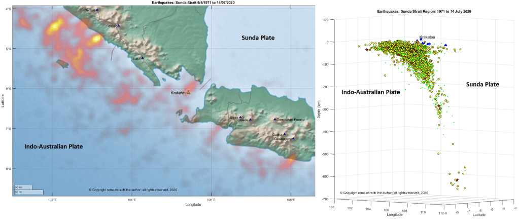
Volcanism in the area is driven by the subduction of the Indo-Australian Plate under the Sunda Plate. The Sunda Strait is seismically very active, possibly because it is accommodating the change in direction between the northern and eastern arms of the plate boundary. Krakatau, itself, lies in the bend of the Arc above the Wadati-Benioff zone.
We looked at the earthquakes in the region 8.67°S 101.00°E to 3.94°S 110.09°E for the period 1971 to 14 July 2020; this area includes the southern end of Sumatra, the Sunda Strait and the western end of Java. We downloaded the earthquake data from IRIS’s earthquake browser. The download comprised mostly earthquakes with magnitude over 4.0; smaller volcanic / tectonic earthquakes were not included in the data set.
Our plots show the subduction zone in the curve of the Sunda Volcanic Arc, with more intense seismic activity in the northern arm of the arc. The intense areas of activity in the northern arm starts in 2000, preceding the 2004 Banda Aceh earthquake, which is north of the area in our plot, and continuing for a few years afterwards.
Having visited Katla, let’s go further north to the Eastern Volcanic Zone and take a look at Hekla.
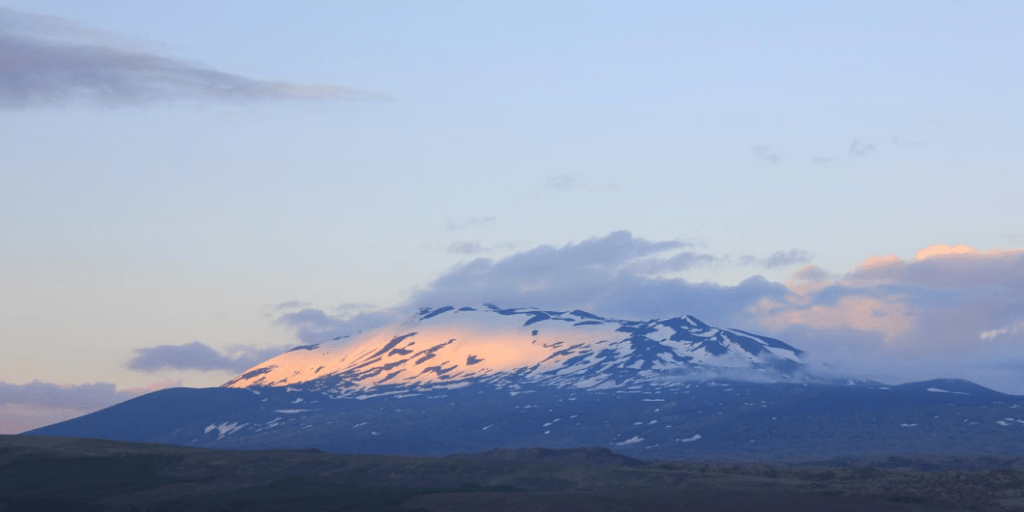
Hekla is an active snow-covered elongated stratovolcano, lying at the southern end of the Eastern Volcanic Zone in Iceland in a rift transform junction. Following the 1104 AD eruption, Hekla was called “The Gateway to Hell” – a name that stuck until the 19th century.
Fig 1: Hekla 22 June 2014; photo by Evgenia Ilynskya (see below for source).
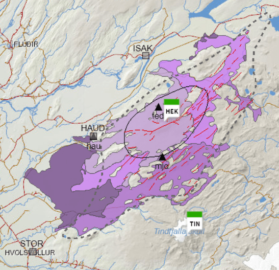
The Hekla volcanic system comprises a 1490m high central volcano and a 60 km fissure swarm. The Heklugjá fissure, 5.5 km long cutting across the central volcano, is the site of many eruptions and gives Hekla its elongated shape. The Vatnafjöll fissure system, 40 km long and 9 km wide is considered part of the Hekla volcanic system. Hekla may have a small magma reservoir 4 km below the surface. She has permanent snow cover but no large glacier.
Fig 2: Hekla’s central volcano, fissure system and some lava flows. Retrieved from Icelandic Volcanoes (see Sources below). GPS and seismic stations are included so we can identify earthquake locations in later plots.
Hekla’s lavas differ from the rift zone volcanoes; her lavas are andesite, basaltic andesite, basalt / picro basalt, rhyolite and dacite. She erupts tephra and silicic to intermediate lavas from the central volcano. Eruptions tend to be a short plinian / subplinian phase followed by lava flows. Larger explosive silicic eruptions have produced enough tephra for the deposits to act as time markers in dating other eruptive activity in Iceland. She is a large fluorine producer which is hazardous to livestock. The hazards listed are tephra fallout, fluorine gas, pyroclastic flows and lava flows; the absence of a large glacier means that jökulhlaups are not a major hazard for Hekla.
The fissure system produces basaltic lavas and a small amount of tephra; its hazards are listed as lava flows and volcanic gas pollution.
Eruptive History
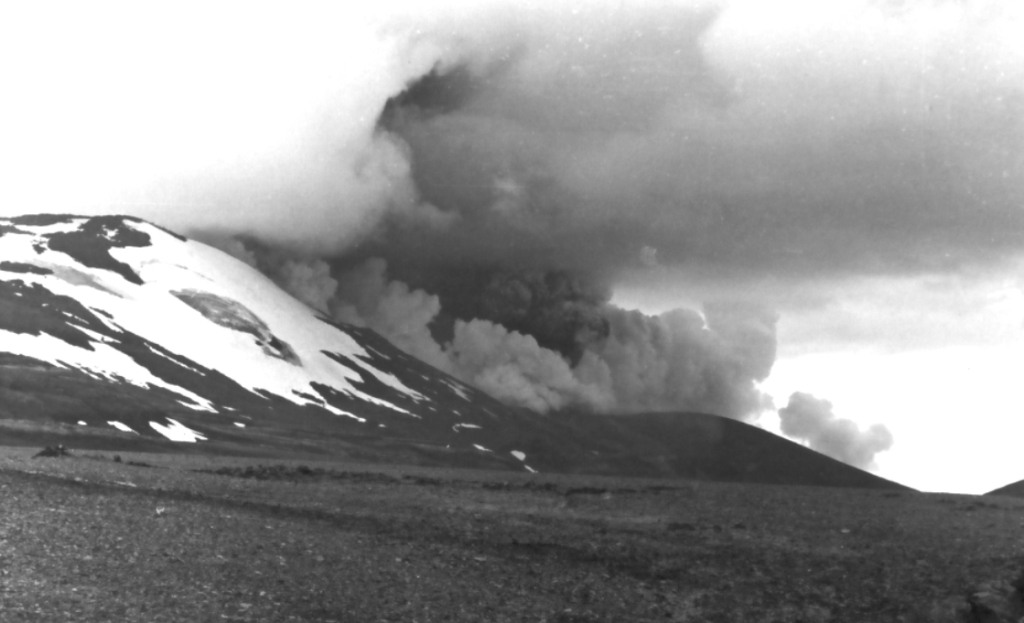
Fig 3: 1980 Eruption of Hekla by oxonhutch at English Wikipedia: Hekla,shared under CC-BY-2.5
According to GVP, Hekla has had 65 Holocene eruptions ranging from VEI 1 to 5. Larsen and Thordarson state that there have been 100 eruptions in the past 9000 years, 23 of which occurred in the last millennium with VEIs ranging from 0 to 5. The central volcano produces eruptions of VEI 2 to 6, VEI 3 to 4 being the most frequent; the longer the repose time between eruptions, the larger the ensuing eruption. The fissure system produces less explosive eruptions (VEI 1 to 2). Hekla’s largest known eruption, a VEI 6, occurred between 3000 to 4300 years ago. Traces of ash from Hekla have been found in Scandinavia, Germany, Ireland and the UK.
Hekla’s eruptive style has changed over time: from effusive basalt 9000 to 7000 years ago; to large explosive silicic eruptions between 7000 to 3000 years ago; and, then smaller more frequent mixed silicic and basaltic eruptions from 3000 years ago to the present day.
The most recent eruption was in 2000, with a VEI 2 to 3, 0.01km3 of airborne tephra 0.01km3 and 0.12km3 of lava; it thought that magma rose through a conduit from a depth of more than 10km to 1km below before heading towards a fissure on the Hekla ridge.
Hekla has an unusually low level of seismic activity. Her largest earthquakes are in the order of 2M when dormant and 3M during an eruption. She does not give much warning of an eruption: known precursors are earthquakes 25 to 90 minutes beforehand. Monitoring has increased since the last eruption so there should be more information about any precursors to future eruptions.
Recent Seismic Activity
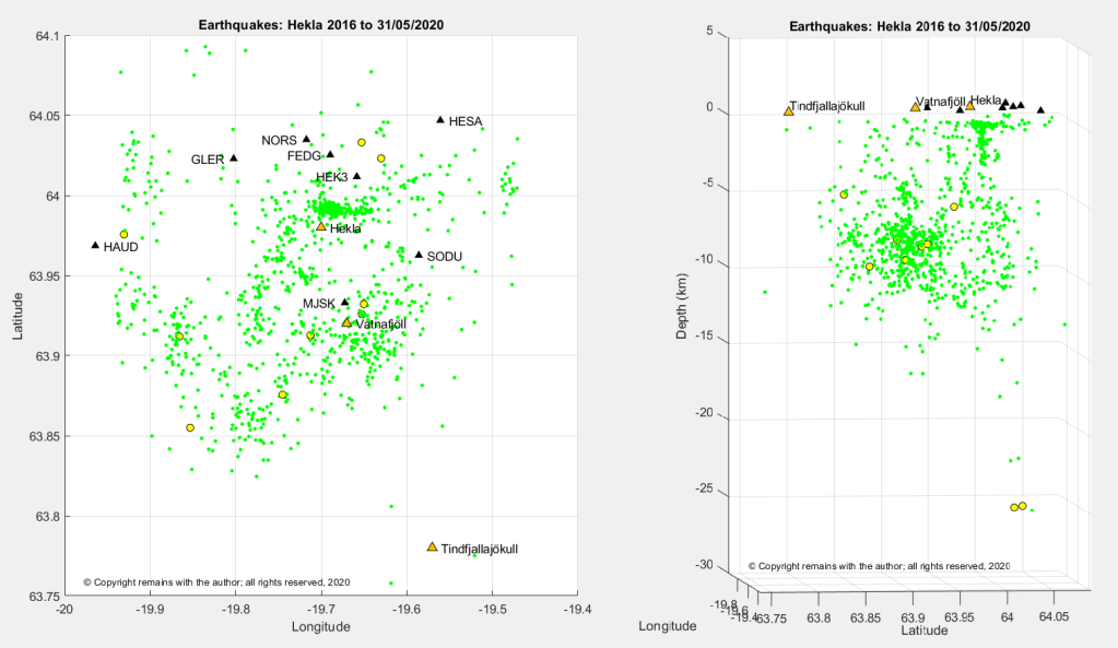
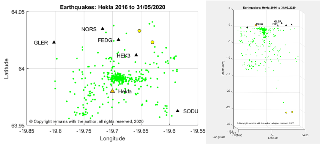
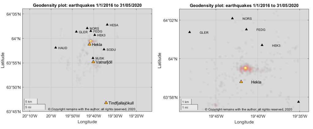
From the data set of earthquakes downloaded from IMO’s site for period 1 January 2016 to 31 May 2020, we extracted those for the Hekla – Vatnafjöll area: 63.7578°N, 19.4687°W to 64.0952°N, 19.9399°W. We found 1,018 earthquakes, compared to Katla’s 6,505 for the same period. The largest quake was 2.62 and the deepest 25.11km.
In our latitude v longitude scatter plot we can see that most earthquake activity is scattered along the fissure systems, with an E-W “cluster” to the south of GPS station HEK3, north of Hekla. The latitude v depth plot shows the activity near Vatnafjöll is occurring in the lithosphere, whereas there appears to be a conduit under Hekla. A close up of the cluster confirms this impression.
We looked for swarms in the data set to see if these account for the hot spot but did not find any large ones; the hot spot appears to be an accumulation of activity over the period. Hekla seems to have a slow magma feed.
“Hekla”, Guðrún Larsen (Institute of Earth Sciences – Nordvulk, University of Iceland) and Thor Thordarson (Faculty of Earth Sciences, University of Iceland). In: Oladottir, B., Larsen, G. & Guðmundsson, M.T., Catalogue of Icelandic Volcanoes. IMO, UI and CPD-NCIP. Retrieved from Icelandic Volcanoes: http://icelandicvolcanos.is/?volcano=HEK
Fig 2: Map: After Jóhannesson and Einarsson (1992), Jóhannesson and Saemundsson (1998a), Larsen et al (2013a), Base data, Iceland Geo Survey, IMO, NLSI | Base map: IMO. In: Oladottir, B., Larsen, G. & Guðmundsson, M.T., Catalogue of Icelandic Volcanoes. IMO, UI and CPD-NCIP. Retrieved from Icelandic Volcanoes: http://icelandicvolcanos.is/?volcano=HEK
Smithsonian Institution Natural History Museum Global Volcanism Program (GVP): https://volcano.si.edu
