Good Afternoon!
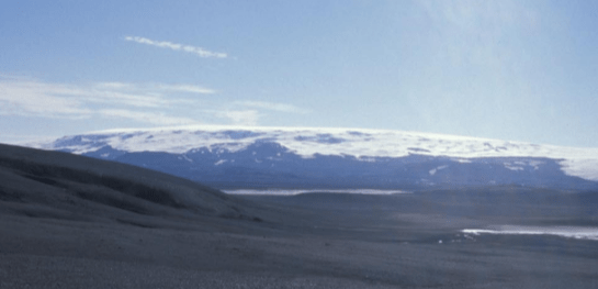
In this post we continue our journey round Iceland’s many volcanoes. We have reached the mighty Barðarbunga at the northwest corner of the Vatnajökull icecap.
Barðarbunga volcanic system lies in the Eastern Volcanic Zone, Iceland, near where the head of the mantle plume is thought to be. The system comprises a 2,000 m high central stratovolcano with a 65 km2, 700 m deep caldera, the Veiðivötn fissure swarm running NE to SW, and the Tröllagigar and the Dyngjuháls – Holuhraun fissure swarms running NE; the entire system is c. 190 km long and 25 km wide.
There is second central volcano in the system, Hamarinn, 20 km south west of the Barðarbunga central volcano. Hamarinn may be younger, indicated by the absence of both an intrusive complex and a caldera.
There are geothermal areas near the caldera rim of Barðarbunga and the east of Hamarinn, the latter is the source of jökulhlaups.
The area is tectonically very active: the Eastern Volcanic Belt accommodates much of the separation between the North American and Eurasian Plates. The area is close to the junction with the Northern Volcanic Zone, where Barðarbunga’s neighbours, Askja and Herðubreið, can be found.
Eruptive History
According to GVP, there are 55 identifiable Holocene eruptive periods for the Barðarbunga system. Some of the eruptive history has been hidden by the ice-cap. However, lavas and tephra deposits on the ice-free sections of the fissures are more accessible.
Barðarbunga Central Volcano
The central volcano has had around 22 eruptions in the last 1000 years, most occurring between 1200 -1500 and in the 18th century. The last known subaerial eruption was in 1910.
Barðarbunga’s lavas are mainly basalt/ picro basalt. Her eruption types are explosive, phreato-magmatic with jökulhlaups, reflecting the impact of the ice-cap. The central volcano produces eruptions in the order of VEI 3 to 4, producing tephra – both airborne and waterborne. There is a silicic tephra layer in the ice-cap dating to the early 18th century but it is not clear that this came from Barðarbunga. If it did, any rhyolite would have come from partial melting of the basaltic crust.
Magma is sourced from a depth of 10 km or more below the caldera; above this source is an intrusive complex and a lower density region, probably of caldera in-fill. Magma may also be sourced direct from the mantle in the fissure swarms.
Fissure Swarms
Fissure swarm eruptions are basaltic in the order of VEI 1 to 2, with a maximum of VEI 6 on the Veiðivötn fissure.
The last three eruptions on the south west fissure swarm were the VEI 4 at Vatnaöldur in 877, the VEI 6 at Veiðivötn in 1477 and the VEI 2 at Tröllagigar in 1862-1864. The first two of these were explosive tephra eruptions, producing 5 km3 to 10 km3 of tephra and small lava flows. Both the Vatnaöldur and Veiðivötn fissures cut into the Torfajökull volcano, causing it to erupt with silicic tephra and lava. The largest known effusive eruption on the SW fissure swarm is the Great Þjórsá lava which covers 900 km2 and reached the south coast via the Tungnaá and Þjórsá river valleys.
The Gjálp eruption in 1996 occurred on a subglacial fissure that links the Barðarbunga and Grímsvötn volcanic systems. While it is thought that the magma was sourced from beneath Barðarbunga, based on seismic and geodetic data, the magma erupted subaerially was characteristic of Grímsvötn’s lavas.
The frequency of eruptions on the northern fissure swarm is not known; the last eruption was at Holuhraun which started on 29 August 2014 and lasted until February 2015. Precursors to this eruption were a build up of seismic activity at Barðarbunga over seven years, which stopped immediately after the Grímsvötn 2011 eruption but resumed soon afterwards. The largest known effusive fissure eruption north of Vatnajökull is the mid Holocene 15 km3 Trölladyngja lava shield.
Holuhraun Eruption 2014 – 2015
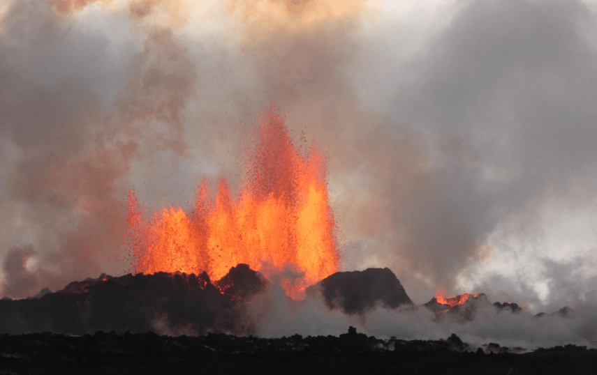
The subaerial eruption started on 29 August 2014 at the Holuhruan vent 45 km NE of the Barðarbunga caldera; the eruption ended on 28 February 2015, having left an 85 km2 lava field and a 65 m deep depression in the Barðarbunga caldera’s ice cover. The eruption was a large SO2 and other volcanic gas producer, however there was little ash or tephra.
The central volcano, Barðarbunga had inflated prior to the eruption then deflated during the eruption as evidenced by subsidence in the ice covering. The volume of the subsidence was consistent with the dyke intrusion and the lava erupted at Holuraun, although there is seismic and geochemical evidence that some of the lava erupted at Holuhraun was fed direct from the mantle. It is estimated that 1.6 km3 lava was erupted.
Since September 2015, seismic and GPS data show that the volcano has started to refill at a depth of 10 to 15 km.
Recent Seismic Activity
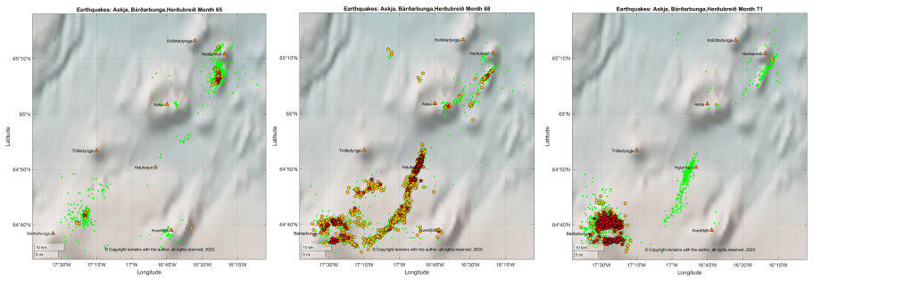
We looked at earthquakes in the Barðarbunga, Askja, Herðubreið and Holuhraun area (64.56°N, 17.65°W to 65.3°N, 16.1°W) for the period 1 January 2009 to 28 June 2020. Not much activity had been noted in the area to the west and south west of Barðarbunga in our earlier plots; however, we had noted that heightened activity at Askja and Herðubreið had preceded the 2014 eruption at Holuhraun which lies between the three volcanoes, hence we included them in our plots. The link between the centres is rifting in the crust to accommodate the separation of the North American and Eurasian Plates.
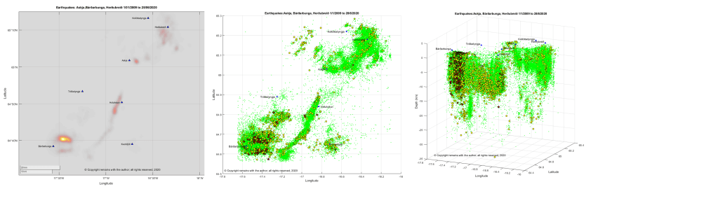
There were 70,128 earthquakes in the period, of which 16,573 occurred before the 2014 -2015 eruption, 19,061 during the eruption and 34,494 post eruption; the average per calendar month was 247 pre eruption, 2,723 during the eruption and 539 post eruption; the maximum magnitude earthquake pre eruption was 3.9 M, during the eruption 5.5 M and 4.9 M post eruption; and, the deepest quakes had respective depths of 33.9 km, 31.0 km and 33.9 km. These numbers include activity at Barðarbunga, itself, the Holuhraun fissure, Askja and Herðubreið. The larger magnitude earthquakes occurred near the north and south caldera rim during the eruption. Since the eruption all four centres have had elevated seismic activity.
Seismicity during the 2014 to 2015 Holuhraun eruption
Three months prior to the eruption, there was an earthquake swarm at Herðubreið, noted here because the rifting event that preceded the Holuhraun eruption occurred on the same plate boundary. Seismic activity at Herðubreið or Askja may be precursors to activity at Vatnajökull, if they, themselves, are not the main event or brewing something. Something to watch out for bearing in mind the recent large swarms in the Tjörnes Fracture Zone and on the Reykjanes Peninsula.
The earthquake plots for August 2014 and November 2014 show the intense swarms from caldera collapse and also the rifting event.
We will look at Askja and Herðubreið in future posts.
The Armchair Volcanolgist
17 July 2020.
© Copyright remains with the author; all rights reserved, 2020.
Sources and Further Reading
“Barðarbunga”, Guðrún Larsen and Magnús T. Guðmundsson (Institute of Earth Sciences – Nordvulk, University of Iceland). In: Oladottir, B., Larsen, G. & Guðmundsson, M.T., Catalogue of Icelandic Volcanoes. IMO, UI and CPD-NCIP. Retrieved from Icelandic Volcanoes: http://icelandicvolcanos.is/?volcano=BAR
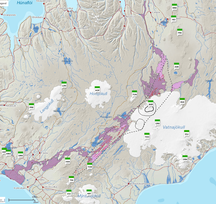
Fig 2: Map. After Björnsson (1988), Gudmundsson and Högnadöttir (2007), Jóhanneson and Saemundsson (1998a & b), Sigurgeirsson et al (2015). Base data, Iceland Geo Survey, IMO, NLSI | Base map: IMO. In: Oladottir, B., Larsen, G. & Guðmundsson, M.T., Catalogue of Icelandic Volcanoes. IMO, UI and CPD-NCIP. Retrieved from Icelandic Volcanoes: http://icelandicvolcanos.is/?volcano=BAR
Smithsonian Institution Natural History Museum Global Volcanism Program (GVP): https://volcano.si.edu
Raw earthquake data: Icelandic Meteorology Office: IMO https://en.vedur.is/earthquakes-and-volcanism/earthquakes
Plots are the author’s own work.
