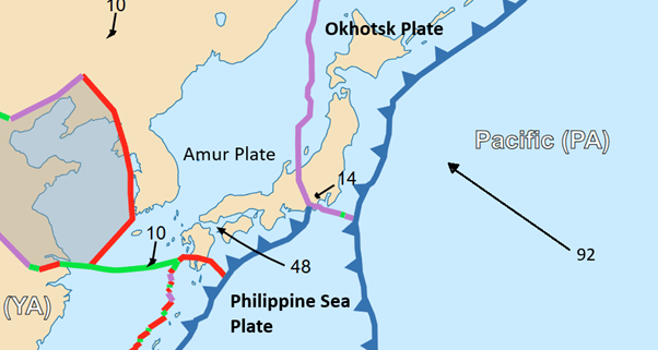
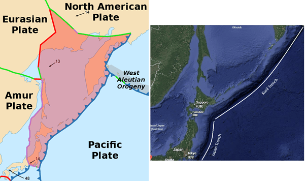
In this article, we are travelling northwards from Mount Fiji to look at the subduction of the north west Pacific Plate under the Okhotsk Plate. Subduction occurs at two trenches: the Japan Trench and the Kuril-Kamchatka Trench. Here, we look at both the Japan Trench and the Kuril-Kamchatka Trench as far as the end of the Kuril Volcanic Arc. We will look at the Kamchatka end of the Kuril-Kamchatka Trench when we look at the junction between it and the Aleutian Arc.
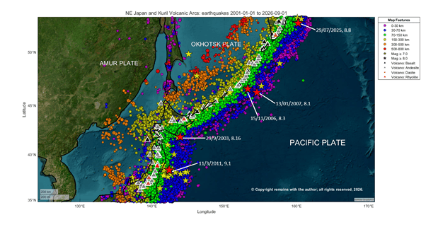
We start by looking at the Japan Trench, then the Kuril Trench, and finish by comparing the two.
Japan Trench
The Japan Trench is a submarine trench in the north western Pacific Ocean, stretching roughly 800 kilometres (497 miles) from the Kuril Islands down to the northern end of the Izu Islands. With a maximum depth is 8,046, the Tuscarora Deep was considered the deepest point on Earth prior to the discovery of the Mariana Trench.
The Trench formed from the subduction of the Pacific Plate under the Okhotsk Plate where the plates converge at a rate of 79 to 92 millimetres per year. Earthquakes associated with the subducting plate extend down as far as 482.3 km in the period we looked at. It is the site of large earthquakes, which often cause tsunamis, for example, large slip-to-trench events. The presence of ultra-slippery pelagic clay, discovered by recent drilling projects, allows faults to snap violently all the way up to the seafloor, shifting the seabed horizontally by dozens of metres, causing catastrophic tsunamis. The 2011 Tōhoku earthquake, with a magnitude of 9.0-9.1 Mw occurred on the Trench, displacing the seabed by 60 m upwards; the resulting tsunami led to the Fukushima nuclear disaster.
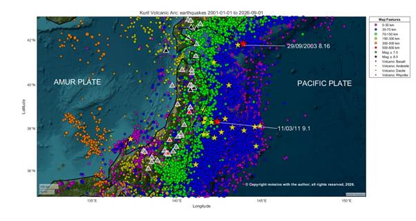
Subduction at the Japan Trench has created the North East Japan Arc of north eastern Honshū and Hokkaidō . The arc has four zones: the volcanic front at the inner arc, an uplift zone, the outer arc and the Hokkaidō Collision Zone. The volcanic front forms the Ōu Mountains (or Backbone Range), the spine of northern Honshū . The uplift zone is non-volcanic. The outer arc is further east, comprising non-volcanic ranges of eroded pre-Tertiary rock. The Hokkaidō Collision Zone is where the North East Japan Arc meets the Kuril Volcanic Zone.
The northern section of the volcanic front includes calderas, acidic geothermal activity and sulphur springs. Volcanoes include Mount Osore, Mount Hakkōda and, Mount Iwaki. The central section comprises highly active explosive stratovolcanoes, including Mount Iwate, Mount Hachimantai and Akita-Komagatake. The southern section of the front is made up of volcanoes characterised by phreatic collapses and frequent historic activity, such as Mount Zaō, Mount Bandai and Mount Adatara.
South western Hokkaidō (The Oshima Zone) represents the northernmost continuation of the North East Japan Volcanic Arc, sharing geological similarities with northern Honshū. It is home to Mount Yōtei, a dormant stratovolcano, Mount Usu, exceptionally active, its 1943 eruption pushed up a brand-new lava dome out of a flat wheat field, creating the mountain Shōwa-shinzan, and Mount Komagatake (Hokkaidō -Komagatake), a highly active volcano on the southern tip of the island, known for violent, explosive Plinian eruptions that periodically collapse its summit.
Central Hokkaidō (The Collision Cluster) is situated directly where the North East Japan Arc meets the Kuril Volcanic Zone. This region contains Hokkaidō ‘s highest peaks, rugged alpine terrain, and intense geothermal systems. Volcanoes include the Daisetsuzan Volcanic Group and Mount Tokachi. Mount Yubari is non-volcanic, comprising metamorphic rock generated by the arc collision.
In Eastern Hokkaidō (The Caldera & Shiretoko Zone) volcanoes are formed by subduction at the Kuril Trench. Volcanoes include Mount Meakan, one of Hokkaidō ‘s most active volcanoes, frequently venting ash and volcanic gases, Kussharo, Japan’s largest caldera by surface area, Mount Io (Atosanupuri), a sulphur-stained volcano, Mount Iō (Shiretoko-Iōzan), and Mount Rausu.
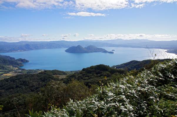
While most volcanoes on the North East Japan Arc are primarily andesitic, there is one rhyolitic volcano, Naruko, comprising a caldera and lava domes, which last had a small eruption in 837 CE; two dacite volcanoes on Honshū, the Omanago Group, which last erupted in 3050 BCE, and, Numazawa, 3400 BCE; two basaltic volcanoes on Honshū, Akita-Koagatake, which last erupted in 1971 CE and Iwatesan, whose last major eruption was in 1732 CE, with a smaller one in 1919 CE; and, three basaltic volcanoes on Hokkaidō , Oshima – Oshima, which last erupted in 1790 CE, Toya, 2001 CE and Kuttara, 1820 CE. While Naruko is relatively close (148 km away) to the site of Fukushima Nuclear Disaster, it does not share the same fault zones; Naruko is on the volcanic front in the Tōhoku Backbone Range, and Fukushima is on the coastal forearc / marine slope.
Kuril Trench
The Kuril-Kamchatka Trench, stretching c. 2,100 to 2,900 km, is a direct extension of the Japan Trench. Its deepest point is 9,600 – 9,717 m. At the Trench, the Pacific Plate subducts under the Okhotsk Plate, with convergence rates from c.75 mm per year in the north to c.83 mm per year in the south. Earthquakes associated with the subducting plate extend down as far as 631.9 km in the period we looked at. The Trench lies off the southeast coast of Kamchatka, running parallel to the Kuril Island chain, with its northern end is at the triple junction with the Ulakhan Fault and the Aleutian Trench, and its southern end meeting the Japan Trench east of Hokkaidō . The Trench is the site of earthquakes with magnitudes over 8.0.
The Kuril-Kamchatka Trench tends to rupture over long distances. Because it is a relatively unobstructed line, single earthquakes can unzip huge stretches of the boundary, for example, the 600 km rupture zone from the 8.8 magnitude 2025 Kamchatka earthquake.
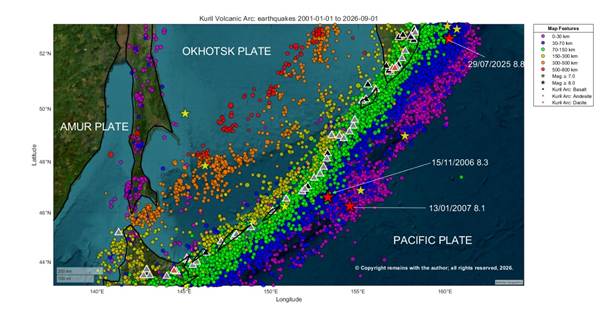
The Kuril Islands, themselves, stretch 1,300 kilometres from Hokkaidō to the southern end of Kamchatka. The islands are the summits of some of stratovolcanoes on the submarine volcanic ridge. There are c.100 volcanoes on the Kuril Islands archipelago 200km west of the Trench. The highest point on the islands is Alaid Volcano, at 2,339 m, on Atlasov Island at the northern end of the chain.
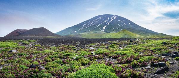
Some of the better known volcanoes include Tao-Rusyr Caldera, with its large 7.5-kilometre-wide caldera, Lake Koltsevoye, Kudryavy (Iturup Island), with high-temperature fumaroles that deposit rare chemical elements, including indium and rhenium, Sarychev Peak, one of the most active volcanoes in the Kuril chain, and Tyatya, with its nested caldera.
As with the Japan Trench most volcanoes have andesite as their primary lava. However, there are 14 basaltic volcanoes, Chachadake [Tiatia], which last erupted in 1981 CE, Prevo Peak, 1825 CE, Raikoke, 2019 CE, Chikurachki, 2023 CE, Alaid, 2022 CE, Kambalny, 2017 CE, Koshelev, 1690 CE, Yavinsky, 4050 BCE, Zheltovsky, 1923 CE, Mutnovsky, 2000 CE, Gorely, 2010 CE, Opala, 1776 CE, Tolmachev Dol, 300 CE, Barkhatnaya Sopka, 3550 BCE; and, three dacite volcanoes, Kussharo, last erupted in1320 CE, Diky Greben, 350 CE, Kurile Lake, 6440 BCE.
Comparison of Seismicity at Both Trenches
Both the Japan and Kuril Trenches are seismically very active and have produced magnitude 9.0 + megathrust earthquakes. The Japan Trench also produces more slower earthquakes and shallow ruptures that create large tsunamis. The Kuril Trench ruptures in regular, massive, deep-fault-coupled blocks that segment from Hokkaidō to Kamchatka.
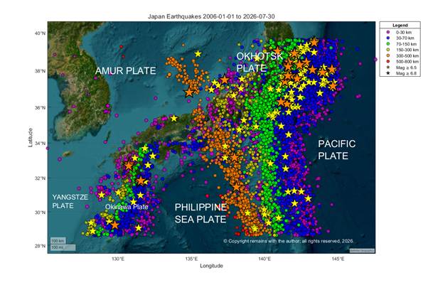
When we look at our plots of seismicity below, notably the 3D scatter plots, we see that there are considerably more earthquakes on the Pacific Plate east of the Japan Trench than the Kuril Trench. This is due to the angle at which the Pacific Plate meets each trench. As the Pacific Plate approaches the Japan Trench it experiences flexural bending. Before the crust can subduct it curves sharply downwards. c. 120 to 150 km east of the plate buckles upwards under pressure. The top layer of the crust cracks under tensional forces as it progresses from the bulge to the steep downwards curve, generating frequent shallow normal faulting earthquakes. The stress from bending creates a pattern of parallel faults known as a horst and graben structure. This also occurs on the Kuril Trench, however, it is greater at the Japan Trench because the west north west moving Pacific Plate meets the north south oriented Trench at a c. 90° angle, whereas at the southwest to northeast oriented Kuril Trench the Pacific Plate hits at an oblique angle so the plates slide slightly along the Trench spreading some of the energy into horizontal faulting in the overriding plate. The Pacific Plate is, therefore, more heavily fractured at the Japan Trench than at the Kuril Trench.
The angle the Pacific Plate approaches the trenches also influences how the trenches rupture. When the plate formed at a mid ocean ridge millions of years ago, lines of weakness were created. At the Kuril Trench, the trench axis is parallel to these lines; it tends to unzip along pre-existing cracks, distributing stress evenly across small, frequent steps (under 400m) with gaps of 4-5km. Whereas at the Japan Trench, the trench axis is at a high oblique angle to the ancient weakness lines; the plate cannot unzip cleanly both new normal faults rupture and older faults are reactivated, creating competing fault networks. Massive amounts of stress are concentrated into fewer much large faults with structural steps of more than 800m. These steps are part of a series of isolated stronger patches, separated by heavily damaged gaps of more than 15km width, making the interface heterogeneous. Bend faults are also hydrated by sea water. Both act as barriers to seismic ruptures; earthquakes tend to be confined to separate smaller, segments. The smaller steps with narrower gaps of c. 4- 5km width of the Kuril Trench create a smoother subduction interface (it is considered homogeneous), with fewer barriers to stop propagating rupture so it is easier for megathrust earthquakes to unzip larger stretches of the plate boundary along pre-existing faults.
Large Recent Earthquakes, Japan Trench
29th September 2003, the M 8.16 Tokachi-Oki earthquake occurred at 41.815°N, 143.910°E near Hokkaidō with 27.0km depth. A slip occurred over an area of 100 x 120km with a downward dip of the hypocentre. It was caused by shallow thrust faulting on, or near, the plate boundary between the Pacific and Okhotsk Plates near both the Japan and Kuril Trenches. Not only does Hokkaidō get shallow large thrust earthquakes that originate from the plate boundary bit it also gests large earthquakes from the interior of the downward subducting Pacific Plate. (M 8.2 – 2003 Tokachi-Oki Earthquake).
Previous large earthquakes occurring in the same rupture of the same section of the plate boundary are the 1952 M8.1 Tokachi – Oki earthquake, 42.084°N 143.899°E, with 45.0 km depth, (M 8.1 – 1952 Tokachi-Oki Earthquake), and, 1968 M8.2 Tokachi – Oki earthquake, 40.890°N, 143.362°E, 26.9 km depth (M 8.2 – 1968 Tokachi-Oki Earthquake). One earthquake occurred inside the Pacific Plate, 1993 M 7.6 – 52 km NE of Otofuke, Japan, 43.300°N, 143.691°E, 102.2 km depth, (M 7.6 – 52 km NE of Otofuke, Japan).
11th March 2011, the M 9.1 Great Tōhoku Earthquake 38.297°N 142.373°E, with 29.0 km depth occurred near the east coast of Honshū on the subduction zone plate boundary. The fault moved 50 to 60m with a slip over an area of 400 x 150 km with a downward dip. The main shock was preceded by large foreshocks in the preceding 48 hour period. (M 9.1 – 2011 Great Tohoku Earthquake, Japan).
Previous large earthquakes in the same area of the Japan Trench are 1978, M 7.7 – 68 km ESE of Ishinomaki, Japan, 38.190°N, 142.028°E, with 44.0 km depth (M 7.7 – 68 km ESE of Ishinomaki, Japan), and 1994, M 7.8 – off the east coast of Honshū, Japan, 40.525°N, 143.419°E. with 26.5 km depth (M 7.8 – off the east coast of Honshū, Japan).
More recently there have been two large earthquakes off northern Japan: a magnitude 7.5 earthquake hit the northern area in December 2025 ( M 7.6 – 2025 Aomori Prefecture, Japan Earthquake), followed closely by a magnitude 7.7 (Mw 7.4) Sanriku earthquake on April 20, 2026 (M 7.4 – 102 km ENE of Miyako, Japan).
Large Recent Earthquakes, Kuril Islands
15th November 2006, the M 8.3 Kuril Islands earthquake occurred at 46.592°N 153.266°E, with a depth of 10km. A slip with an area of 260 x 80km, with an up dip to the north east of the hypocentre. The main shock was withing 80km of the trench axis (M 8.3 – 2006 Kuril Islands Earthquake).
13th January 2007, M 8.1 2007 Kuril Islands Earthquake, 46.243°N 154.524°E, with 10.0 km depth. A slip with an area of 150 x 50km occurred with down dip of the hypocentre. This was shallow east striking or south west striking moderately dipping normal faulting within the Pacific Plate. The epicentre was east of the Kuril Trench, 95 km east south east of the 2006 earthquake (M 8.1 – 2007 Kuril Islands Earthquake).
29th July 2025, M 8.8 – 2025 Kamchatka Peninsula, Russia Earthquake, 52.495°N,160.240°E, with 35.0 km depth. This was the main shock of a swarm of 4,600 earthquakes which started ten days earlier, which included a M7.4 on 20th July 2025 and three M6.6s. The earthquake was shallow reverse faulting with on the subduction zone interface, with a slip area of 390 x 140 km (M 8.8 – 2025 Kamchatka Peninsula, Russia Earthquake).
Other previous large earthquakes near the Kuril Trench are: 1915 c.M 8.0 Central Kuril Islands, 48.392°N, 155.000°E, with 30.0 km depth (M 7.8 – 266 km SSW of Severo-Kuril’sk, Russia), 1952. M 9.0 – 89 km ESE of Petropavlovsk-Kamchatsky, Russia, 52.623°N,159.779°E, with 21.6 km depth (M 9.0 – 89 km ESE of Petropavlovsk-Kamchatsky, Russia), 1963 M 8.5 – 1963 Kuril Islands Earthquake, 44.872°N 149.483°E, with 35.0 km depth (M 8.5 – 1963 Kuril Islands Earthquake). The 1952 earthquake ruptured 600 km of the subduction zone interface.
Our last video is of the 3D scatter plot of the two trenches together. In this we can see the collision zone between the North East Japan Volcanic Arc and the Kuril Volcanic Arc at Hokkaidō . We can also see the plate tear in the Pacific Plate which accommodates the change in direction of subduction between the Japan and Kuril Trenches (shows as an inverted V within the deeper earthquakes).
We hope you have found our article useful.
Armchair Volcanologist
© Copyright remains with the author; all rights reserved, 2026.
Sources
We have used Google’s AI in compiling this article, in addition to our usual searches. This has made the trail to original works less clear. Our apologies, if your work has not been accredited; we will happily correct.
Ikuko Wada, Jiangheng He, Akira Hasegawa, Junichi Nakajima, “Mantle wedge flow pattern and thermal structure in Northeast Japan: Effects of oblique subduction and 3-D slab geometry.”, in Earth and Planetary Science Letters, 15 September 2015, 76-88, Volume 426, doi: 10.1016/j.epsl.2015.06.021
Fujie, G., Kodaira, S., Kaiho, Y. et al. Controlling factor of incoming plate hydration at the north-western Pacific margin. Nat Commun 9, 3844 (2018). doi: 10.1038/s41467-018-06320-z
Azuma, R., Hino, R., Fujie, G., Obana, K., Ohta, Y., & Kodaira, S. (2025). Seismic structure characterizing the large shallow slip zone of the 17th-century Kuril earthquake. Journal of Geophysical Research: Solid Earth, 130, e2024JB030764. doi: 10.1029/2024JB030764
Jean-Paul Cadet, Kazuo Kobayashi, Jean Aubouin, Jacques Boulègue, Christine Deplus, Jacques Dubois, Roland von Huene, Laurent Jolivet, Toshihiko Kanazawa, Junzo Kasahara, Kinichiro Koizumi, Serge Lallemand, Yasuo Nakamura, Guy Pautot, Kiyoshi Suyehiro, Shin Tani, Hidekazu Tokuyama, Toshitsugu Yamazaki, “The Japan Trench and its juncture with the Kuril Trench: cruise results of the Kaiko project, Leg 3”, Earth and Planetary Science Letters, May 1987, 267-284, Volume 83, Issues 1–4, doi: 10.1016/0012-821X(87)90071-9
Wikipedia:
Kuril–Kamchatka Trench – Wikipedia
Raw earthquake data: USGS Earthquakes | U.S. Geological Survey
Volcano data: Global Volcanism Program, 2026. [Database] Volcanoes of the World (v. 5.4.0; 7 Aug 2026). Distributed by Smithsonian Institution, compiled by Venzke, E. doi: 10.5479/si.GVP.VOTW5-2026.5.4
References to individual earthquakes mentioned have been included in the text above.