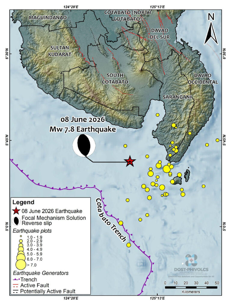
On 8th June 2026 at 07:37 (local time) a 7.8 magitude earthquake occurred 32 km south west of Maasim in Sarangi Province, off the coast of Mindanao Island, Philippines, with a depth of 33 km. Tragically, at the time of writing reports suggest that at least 55 people were killed, 38 missing, 1,120 injured, with 390,000 people impacted. Severe infrastructure damage has impacted rescue and recovery services. A tsunami, with waves ranging from a few centimetres to 1.4 metres, was recorded. Our thoughts are with all those affected now and in the coming months.
Tectonic Setting
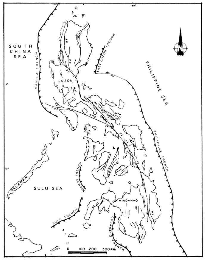
The Philippines is an archipelago made up of c.7,641 islands. It lies on the Philippine Mobile Belt, a zone lying above two opposing subduction zones: the Sunda Plate along the western edge at the Manila, Negros and Cotabato Trenches ; and, the Philippine Sea Plate on the eastern edge along the Philippine Trench and the East Luzon Trough. The Philippine Mobile Belt, itself, is the result of oblique collision between the westward-moving Philippine Sea Plate and the eastern margin of the Sunda Plate. It is rapidly deforming, made up of fragments of continental and oceanic crust.
The 7.8 earthquake was reverse thrust and attributed to movement at the Cotabato Trench.
The archipelago has three main geological features:
- The 1,200-kilometer-long Philippine Fault Zone; a strike-slip fault system which accommodates much of the shearing force caused by the colliding plates. It is seismically active producing large earthquakes, including the destructive M7.6 Luzon earthquake of 1990.
- Volcanism from the subduction. The Philippines is home to numerous active volcanoes, e.g., Taal, Mayon and Mount Pinatubo
- A complex structure containing a mixture of ancient metamorphic rocks (dating back to the Jurassic and Cretaceous periods), early volcanic arcs, and microcontinental blocks.
- The 7.8 earthquake is attributed to movement at the Cotabato Trench.
All in all, an interesting are to study seismicity.
Our Plots
We looked at the area 4.4150°N, 116.16°E to 21.1218°N, 137.90°E for the period 1st January 2016 to 11th June 2026 (07:33 am). Our raw data was downloaded publicly available earthquake data from USGS, a total of 7,357 earthquakes with a minimum magnitude of 3.7 and maximum depth of c.668 km.
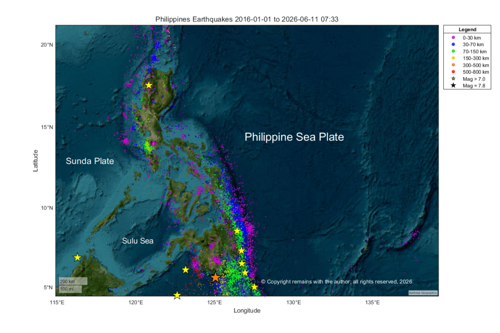
In our Geoscatter plot, we can clearly see the seismicity on the Manila Trench, west of Luzon, the Philippine Trench east of the Philippines, the Philippine Fault Zone to the west of the Philippine Trench and other trenches. Activity along the Philippine Trench dominates the plot. Most of the earthquakes with magnitude greater than 7.0 are associated with subduction at the Philippine Trench.
We can also see some deeper activity in the southern part of the plot. We think that this is related to the fully subducted Molucca Sea Plate which lies to the south of the Philippine Mobile Belt. The Molucca Sea Plate lies between the southeastward subducting Sangihe Plate and the northwestward subducting Halmahera Plate; the collision zone is thought to be arc to arc collision rather than the more usual arc to continent collision. This shows better in our scatter plot below.
In the video we can see that most of the magnitude seven and over earthquakes occur in the region between 0 to 100 km in the southern part of the region and a few are occurring at a depth of over 600 km. The former are mostly associated with the Philippine Fault Zone and the Philippine Trench.
We hope you find the earthquake plots useful.
Once again, our thoughts are with all those impacted by the earthquake.
Armchair Volcanologist
© copyright remains with the author; all rights reserved, 2026.
Sources:
USGS: https://earthquake.usgs.gov/earthquakes
China Daily Asia: Philippine quake death toll reaches 55, search on for 38 missing
PhiVolcs: PRIMER ON THE 08 JUNE 2026 MAGNITUDE (MW) 7.8 OFFSHORE SARANGANI EARTHQUAKE | PHIVOLCS
