Updated 04/08/2022, Fagradalsfjall
A new eruption started at c13:18 yesterday, 3rd August 2022. We are following this on a new thread, A New Eruption Near Fagradalsfjall, Iceland, Started 3rd August 202.
Update 02/08/2022, 20:39:46, Fagradalsfjall and Grímsvötn
The earthquake swarm near Fagradalsfjall continues unabated. The aviation code for Grímsvötn has been raised to yellow following increased seismic activity there.
Fagradalsfjall
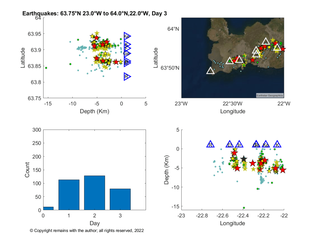
At the time of writing IMO were reporting 3,000 earthquakes in the last 48 hours detected by the SIL Seismic Network.
Rising magma has caused some large triggered earthquakes where existing faults slip to accommodate the strain, the largest so far being 5.47 on day 2 of the swarm.
The Icelandic media are reporting that new satellite images taken on 1 August 2022 show magma movements located between Fagradalsfjall and Keilir. The magma intrusion is shallow at c. 1 km below the surface. The magma influx is close to double the rate of the previous eruption. The chances of an eruption near Fagradalsfjall in the coming days or weeks have therefore increased and are considered to be significant.
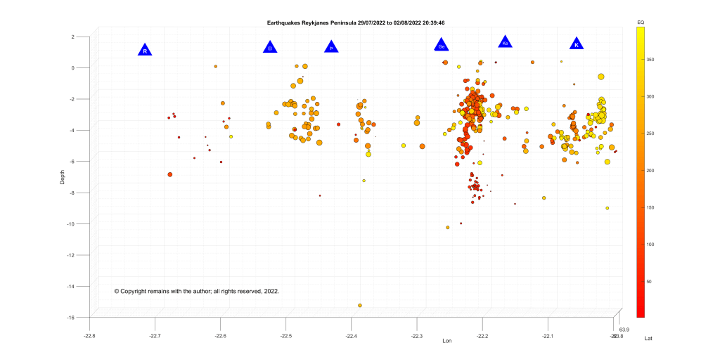
We have updated our earthquake plots using confirmed earthquake data from IMO’s Skjálfta-Lísa for the area 63.75°N, 23.0°W to 64.0°N, 22°W (the western Reykjanes Peninsula). The geodensity plot shows that most of the action is centred north east of Fagradalsfjall.


Grímsvötn
The image from IMO below shows the earthquake activity at Grímsvötn.

Hopefully, eruptions are not like buses – wait for ages, then several show up together. On a more serious note, if Grímsvötn does erupt, ash may be problematic for Europe depending on the size of the eruption and the prevailing wind direction. A jökulhlaup caused by melting of the ice-cap is another hazard. An eruption near Fagradalsfjall is less likely to produce a lot of ash unless magma encounters an aquifer or other body of water; lava and any gas emissions depending on volume and location are likely hazards. Seismic activity remains a hazard for both; the public are advised of the risk of rockfall and landslip.
Armchair Volcanologist
© Copyright remains with the author, all rights reserved, 2022.
Source:
Raw earthquake data: Skjálfta-Lísa
News report: Kvikugangurinn liggur mjög grunnt | RÚV (ruv.is)
Original post 31/07/2022
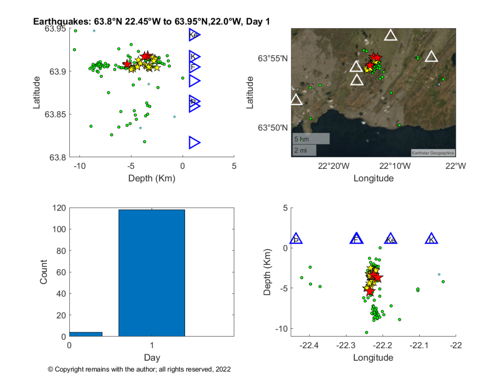
A large earthquake swarm started yesterday (30/07/2022) lunchtime north east of Fagradalsfjall, Iceland. At the time of writing, IMO had reported 1,597 earthquakes in the last 48 hours for the Reykjanes Peninsula from the SIL seismic network. This network automatically detects and locates earthquakes in Iceland and the surrounding offshore region. 199 of these earthquakes had been confirmed.
At the moment the swarm is being likened to the swarm in December 2021, which did not result in an eruption. The local authorities are warning of the increased risk of rockfall as a result of increased seismic activity.

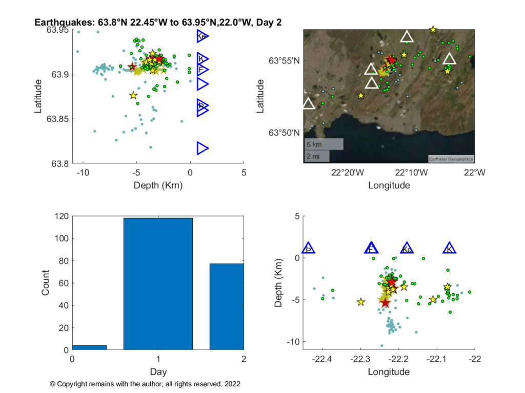
We have downloaded the earthquakes reported from the Table tab and plotted the confirmed earthquakes (quality 99.9%).

For more up to date information, please consult the Icelandic Met Office, Home-page – Icelandic Meteorological Office | Icelandic Meteorological office (vedur.is)
Armchair Volcanologist
Sources: in the article.
