Updates on Seismicity in the Mount Þorbjörn Area, 17th April 2022 to date

Good Evening!

Update 26th May 2022

Seismic activity continues in the Svartsengi area, extending to the Sundhnúkur crater row.  The earthquakes in the vicinity of Mount Þorbjörn appear to be getting shallower today as at the time of writing. 

The Sundhnúkur crater row erupted c. 2,360 years ago. It is accredited with creating the Hópsnes/Þórkötlustaðanes land spit to the east of Grindavík.  

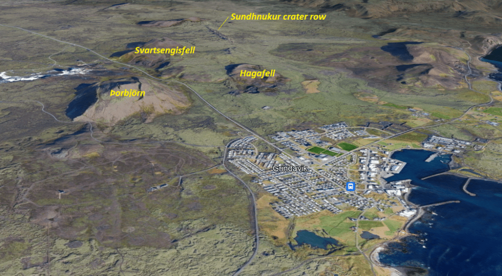
Fig 8: Bird’s eye view of the Svartsengi area and Gringavík.  Image from Google Earth; yellow text added by the author.

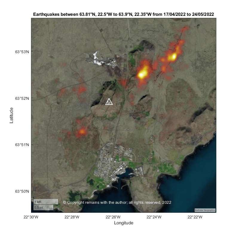
Here are our updated earthquake plots to 26th May 2022 15:06.

Fig 9: Summaries of Days 39 (25th May 2022) and 40 (26th May 2022) by the author. Grey & green circles denote earthquakes < 3M, yellow stars between 3M and 4M and red stars ≥4M. Blue triangles denote volcanoes: K is Krýsuvík, Ke is Keilir, F is Fagradalsfjall, Ge is Geldingadalir, Þ is Þorbjörn, El is Eldvörp and R is Reykjanes.  © Copyright remains with the author; all rights reserved, 2022.
Fig 10: Earthquake plots depth by day by the author for the area 63.81°N, 22.5°W to 63.90°N 22.35°W from 17th April 2022 (Day 1) to 26th May 2022 (Day 40).  Size denotes magnitude.  © Copyright remains with the author; all rights reserved, 2022.
Fig 11: Geodensity plot of earthquakes by the author for the area 63.81°N, 22.5°W to 63.90°N 22.35°W from 17th April 2022 (Day 1) to 26th May 2022 (Day 40).  © Copyright remains with the author; all rights reserved, 2022.
Fig 12: Latitude v Longitude scatter plot of the area 63.81°N, 22.5°W to 63.90°N 22.35°W from 17th April 2022 to 26th May 2022. Colour indicates age: red, oldest; and, yellow, youngest.  © Copyright remains with the author; all rights reserved, 2022.

The following video shows both the geoscatter plots by day from 17th April 2022 to 26th May 2022 in the swarm for the western Reykjanes Peninsula, and the scatter plots for the same period for the area around Mount Þorbjörn.

Fig 13: Video by the author of the geoscatter plots and scatter plots from which the above images have been extracted. Keys are in the video.  © Copyright remains with the author; all rights reserved, 2022.

While the earthquake plots are highly suggestive of more shallow magma ascent, we need to bear in mind that this area is on the plate boundary, the Mid Atlantic Ridge. Some of the seismic activity may be existing faults moving to accommodate the magma. Time will tell when and where magma emerges.

For the latest updates and alerts, please consult with IMO or the local authorities.

Armchair Volcanologist

Original Post 24th May 2022

The earthquake swarm that started on 17th April 2022 on the western Reykjanes Peninsula continues.  Today we are plotting activity at the Svartsengi area near Mount Þorbjörn, which lies to the north of Grindavík, Iceland. We have used Mount Þorbjörn as the marker for Svartsengi in our plots.

Fig 1: Image cropped from one by Arian Zwegers of the Blue Lagoon looking towards Mount Þorbjörn.  Published under CC-BY SA-2.0.  Source: Þorbjörn (mountain) – Wikipedia

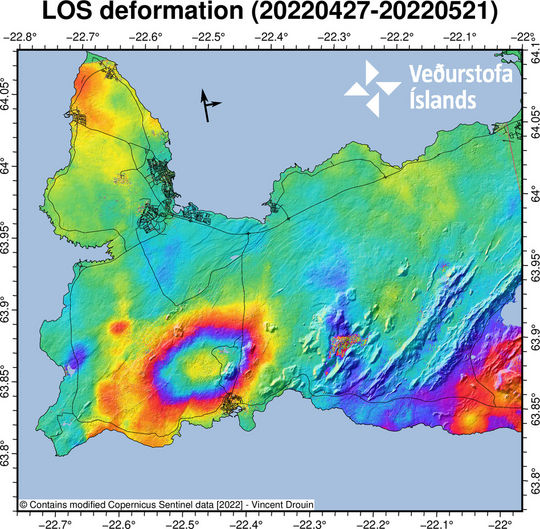
 IMO reports that there has been significant uplift of 40mm to 45mm during the swarm in the area north of Grindavík indicative of magmatic activity.

Fig 2: Ground deformation (Source: IMO, Talsverð skjálftavirkni á Reykjanesskaganum)
Fig 3: Stations in the area showing uplift.  Source for each station: Icelandic Meteorological Office

Let’s look at the earthquakes.

Western Reykjanes Peninsula

Initially, we updated our plots of the area between 63.75°N,23.0°W to 64.0°N, 22°W.  Here is a summary.

Fig 4: Plots by the author of earthquake activity from 17th April 2022 (Day 1) to 24th May 2022 (Day 38) between 63.75°N,23.0°W to 64.0°N, 22°W . Grey & green circles denote earthquakes < 3M, yellow stars between 3M and 4M and red stars ≥4M. Blue triangles denote volcanoes: K is Krýsuvík, Ke is Keilir, F is Fagradalsfjall, Ge is Geldingadalir, Þ is Þorbjörn, El is Eldvörp and R is Reykjanes. Day 38 shows the earthquakes to date in the swarm.  The video below shows the progression of the swarm by day.  © Copyright remains with the author; all rights reserved, 2022.

From a simpler scatter plot and a geodensity plot, we can see much of the activity has occurred near Mt Þorbjörn or Svartsengi in the area enclosed in the green box below.

Fig 5a: Latitude v. longitude scatter plot by the author of earthquakes between 63.75N,23W to 64.0N,22W from 17th April 2022 to 24th May 2022. Colour denotes age (red being the oldest and yellow the most recent).  Blue triangles denote volcanoes: K is Krýsuvík, Ke is Keilir, F is Fagradalsfjall, Ge is Geldingadalir, Þ is Þorbjörn, El is Eldvörp and R is Reykjanes. The green square is the area selected for further analysis today (63.81°N, 22.5°W to 63.90°N, 22.35°W). © Copyright remains with the author; all rights reserved, 2022.
 Fig 5b: Geodensity plot by the author of earthquakes between 63.75N,23W to 64.0N,22W from 17th April 2022 to 24th May 2022. © Copyright remains with the author; all rights reserved, 2022.

Let’s look more closely at the area around Mt Þorbjörn.

Svartsengi Area, 63.81°N, 22.5°W to 63.90°N, 22.35°W

Fig 6: Plots by the author of earthquake activity from 17th April 2022 (Day 1) to 24th May 2022 (Day 38). Grey & green circles denote earthquakes < 3M, yellow stars between 3M and 4M and red stars ≥4M. Blue triangle is Þ, Þorbjörn. © Copyright remains with the author; all rights reserved, 2022.
 Fig 7a: Latitude v. longitude scatter plot by the author of earthquakes between 63.81°N, 22.5°W to 63.90°N, 22.35°W from 17th April 2022 to 24th May 2022. Colour denotes age (red being the oldest and yellow the most recent).  Blue triangle is Þ,  Þorbjörn. © Copyright remains with the author; all rights reserved, 2022.
 Fig 7b: Geodensity plot by the author of earthquakes between 63.81°N, 22.5°W to 63.90°N, 22.35°W from 17th April 2022 to 24th May 2022. The Svartsengi geothermal plant and Blue Lagoon are to the north of Þorbjörn and Grindavík is to the south. © Copyright remains with the author; all rights reserved, 2022.

For more up to date information on the seismic activity and the latest alerts, please refer to the local authorities or the Icelandic Met Office, IMO.

Armchair Volcanologist

© Copyright remains with the author; all rights reserved, 2022.

Sources

Raw earthquake data: IMO