At the time of writing, the Svartsengi Volcanic system has not erupted, despite ongoing ground deformation. We have based this article on a recent update from the Icelandic Meteorological Office, IMO. Rather than writing “IMO says” in every other sentence we are giving a blanket accreditation to them. Apart from our own earthquake plots, and the comments thereon, and the image of Sýlingarfell, all facts reported here are from IMO.
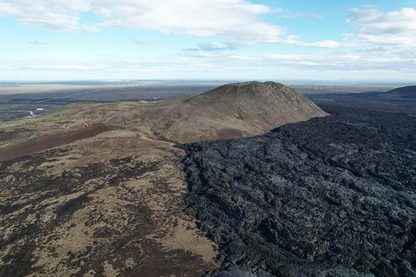
Fig 1: Image of Sýlingarfell surrounded by recent lava taken by Steinninn on 6 August 2024, published under CC BY 4.0, via Wikimedia Commons.
Ground deformation and low level seismic activity has continued. There has been c.4 cm uplift in the last three months, indicating that pressure is building at depth. The most likely outcome still remains, i.e. a magma intrusion will occur, which may lead to an eruption.
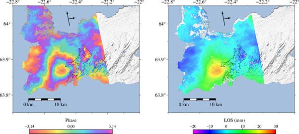
Fig 2: The InSAR image above shows continued ground uplift at Svartsengi between 20 July and 13 September 2026. InSAR uses comparisons of satellite radar images to measure ground deformation. The black outlines mark lava fields formed during previous eruptions along the Sundhnúkur crater row and at Fagradalsfjall. The image was produced using data from the TerraSAR-X satellite. The German Aerospace Center (DLR) provided the data through the GEO-GSNL initiative, supported by CEOS, an international forum for satellite-based Earth observation. Source: Situation on the Reykjanes Peninsula | News | Icelandic Meteorological office.
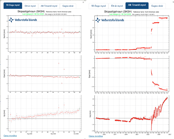
Fig 3: Time series from the SKSH GPS station. On the left the series shows horizontal and vertical displacements from early July 2026 to early October 2026. The vertical displacement shows that uplift is continuing and indicates ongoing magma accumulation beneath Svartsengi. On the right, we have added the series for the period October 2014 to October 2026. The vertical displacement shows the initial sharp drop when the graben formed in November 2023, followed by the December 2023 eruption; subsequent eruptions have been preceded by upward deformation with sharp drops at the onset of each eruption.
While ground deformation continues at its current rate, the alert level remains at orange. If deformation ceases for more than three months, the level will be reduced to yellow. If subsidence occurs and continues for more than six months the level will be reduced to green.
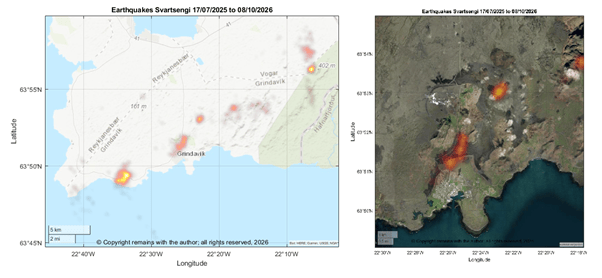
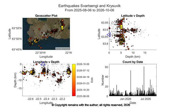
As noted above, seismicity remains low. We have updated our earthquake plots for the period, 6th August 2025 to 8th October 2026. The earthquake density plots show three hot spots near Svartsengi: the largest is southwest of Grindavík at Berghraun, the next is curved round the east and south of Mount Þorbjörn, and the most northerly one is eastward of Sýlingarfell. It’s too early to say whether these are indicative of magmatic activity at these sites or are faults moving to accommodate the uplift at Svartsengi. The scatter plots indicate doming under Svartsengi.