On 10th August a destructive Earthquake of 7.4 struck SW of San José del Palmar, Colombia, with a depth of 110.3km. At the time of writing, 294 fatalities have been reported with 3,935 injured, 14,493 homes destroyed and 81,506 homes damaged. Our thoughts go out to all those impacted.
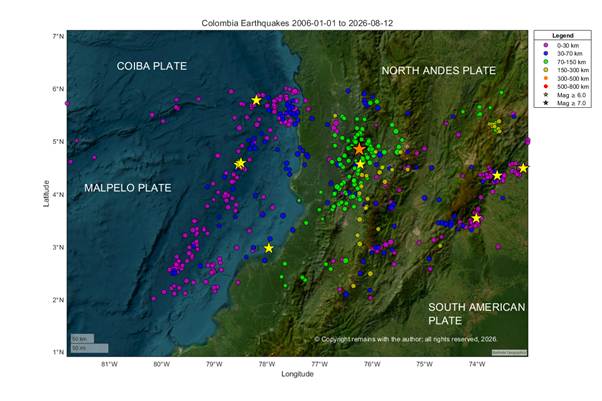
San José del Palmar lies on the North Andes Plate east of the junction between the Coiba Plate, Malpelo Plate and North Andes Plate. Seismicity and volcanic activity in the region is driven by the subduction of the Malpelo Plate under the North Andes Plate. Monday’s earthquake occurred in the descending Malpelo Plate, the result of primarily strike-slip faulting at a depth of approximately 110 km.
We plotted the earthquakes from 1st January 2006 to 12th August 2026 between 2°N,73°W to 6°N,82°W using publicly available data from USGS.
We hope you find the above plots useful.
While we were researching this earthquake news is breaking today of a 7.7 earthquake in Indonesia. Our thoughts go out to those impacted by this earthquake. We will look at this in more detail in our next post.
Armchair Volcanologist
© Copyright remains with the author; all rights reserved, 2026.
Sources:
Raw earthquake data

