Taking a break from eruptions and seismic activity in Iceland, and disasters, in this article, we are taking a look at subduction zone volcanism, with Mount Fuji as our example.
Mount Fuji is stratovolcano located 100km south west of Tokyo in Honshu, Japan, in the Fuji-Hakone national park. The main crater is 780 m diameter at the top, 100 -130 m diameter at its base, and 240 m deep. The highest point, the Kengamine Peak, 3776 m, was built during the Kengamine eruption c.2,300 years ago, the last known summit eruption. The most recent eruption was the 1707 Hoei eruption.
Fujisan is one of Japan’s three holy mountains, the others being Mount Tate and Mount Haku. It was viewed as a living god and a bridge between Earth and Heaven by ancient peoples. In the Shinto religion, Konohanasakuya-hime is a goddess representing fire and volcanoes. There are shrines to her at the summit and foot of the volcano to calm volcanic fire. Buddists climb the volcano for spiritual meditation and enlightenment.
Mount Fuji is a very popular tourist destination due to its natural beauty and climbing trails. It was declared a world cultural site in 2013.
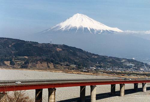
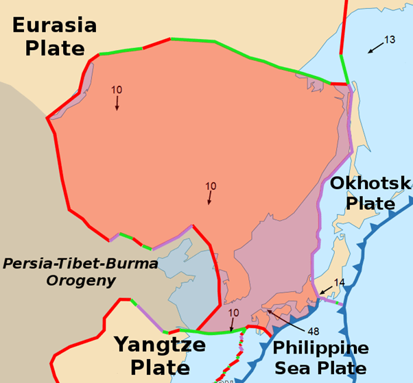
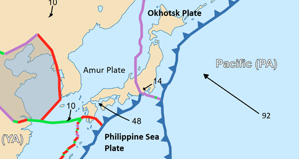
Tokyo, the capital and economic centre of Japan and a major international finance centre, has a population of 14 million; the Greater Tokyo area has one of 33 million. According to Wikipedia, in 2022, Tokyo’s gross regional product was US$887.9 billion, accounting for 21.2% of the country’s total economic output. Of the total output, wholesale and retail was 21.5, real estate (13.5%), professional, scientific and technical (12.2%), information and communications (11.7%), finance and insurance (7.6%), manufacturing (7.0%), and healthcare (6.7%). Agriculture, forestry and fishery, and mining combined accounted for less than 0.1% of the economic output. Lying near the boundary of three tectonic plates (the Okhotsk, Amur Philippine Sea Plates) and also on the Kantō Plain, Tokyo is at risk from earthquake and volcanic activity, and also floods, especially when typhoon rains swell the many rivers on the Plain.
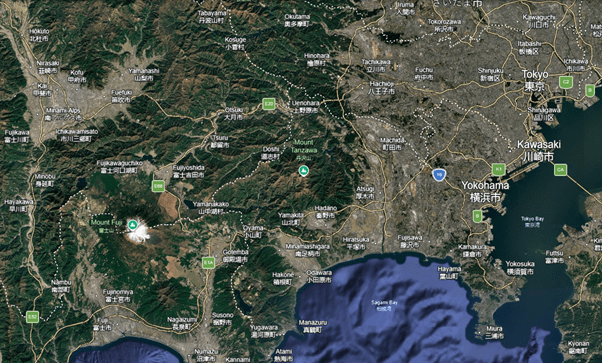
While Tokyo is the largest conurbation near Mount Fuji, there are several heavily built up areas nearby, including the cities of Yokohama, Fujinomiya, Gotemba, Fujiyoshida, Fuji City, Fujikawaguchiko, Numazu, Kofu, Hakone and Odawara. The Smithsonian Institute National Museum of Natural History Global Volcanism Program (GVP) notes that a population of nearly 1 million live within 30km of the summit and just over 25 million live within 100 km. At the time of writing, Google’s AI gives a figure of between 30 – 37 million for people living within 100km of the summit (multiple searches gave different answers but all were in this ball park).
Hazards
The main hazards posed by Mount Fuji, itself, which may cause fatalities and injuries, damage health, livestock, crops, buildings, infrastructure and communications are:
- Eruptive products: ash, cinders, lapilli and lava.
- Lahars and flooding from rains, which may include typhoon rains.
- Debris avalanche flows caused by volcanic or seismic activity.
- Differing eruptive styles complicating predictions
Other local geological hazards include large destructive earthquakes as the region is tectonically very active.
It is worth noting that because Mount Fuji is close to densely populated areas, including the capital the site of government and a large international financial market), the impact of any large future eruption could be not only be nationally but also globally significant.
The volcano is closely monitored by several agencies coordinated by the Japan Meteorological Agency.
Evolution
Mount Fuji last erupted in 1707-1708 with a large explosive eruption of VEI 5, preceded 49 days earlier by a the magnitude 8.7 Hoei earthquake on the Nankai Trough, a 900 km trough off the southern coast of Honshu where the Philippine Sea Plate subducts under the Amur and Okinawa Plates. The eruption was Plinian, occurring on the SE flank of the volcano. Erupted products were mostly pyroclastic, starting with dacite pumice, followed by andesitic scoria, and, finally, basaltic scoria. Ash fall several centimetres thick reached Edo (now Tokyo). The ashfall damaged crops in the region causing widespread starvation. Rainfall combined with ash deposits caused multiple lahars and flooding. Most fatalities were caused by flooding, landslides and famine. It took nearly 100 years for the region to recover.
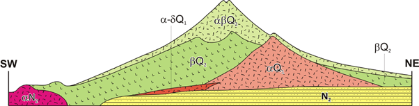
While the last eruption was explosive, Mount Fuji has produced effusive eruptions in its past. Studies of lavas show that Mount Fuji overlies older volcanoes.
Sen-komitake is an andesitic core discovered in 2004. Andesitic activity started here 270,000 years ago ending 160,000 years ago.
Komitake – Fuji is a basaltic layer several hundred thousand years old. Large basaltic lava flows started here started 700,000 years ago, ending 100,000 years ago, .
Old Fuji formed over Komitake – Fuji between100,000 to 17,000 years ago, the Hoshiyama stage. Activity in this period is explosive with Plinian or sub-Plinian eruptions, dominated by ash clouds, heavy pyroclastic flows, mudflows, and massive scoria fall. Komitake – Fuji was nearly completely covered. Around 18,000 BC the edifice collapsed with a large debris avalanche flow to the southwest, forming the Tanukiko debris avalanche deposit. This was followed by another collapse eastwards c. 12,000 BC forming the Umafusegawa debris avalanche deposit.
New Fuji formed over old Fuji during the Fujinomiya stage from 15,000 BC to 6,000 BC. The new edifice was constructed within the Tanukiko avalanche scar. The eruptive style switched back to large effusive basaltic lava flows, including the Mishima, Obuchi and Saruhashi lava flows. The Mishima lava flow is estimated to have a volume of 4.3 km3 and the Obuchi 1.1 km3. The Saruhashi lava flow is the longest, extending more that 40 km from the summit.
From 6,000 BC to 3,600 BC, the Subashiri – a stage, activity declined considerably. Only Fuji black soil round the volcano remains.
The Subashiri – b stage, from 3,600 BC to 1,700 BC, marked an increase in activity during which the current cone was built from thin basaltic lava flows up to 2,100 BC. Effusive flank eruptions also occurred during this period.
The Subashi – c stage, 1,700 BC to 300 BC was marked by initial explosive basaltic Plinian or sub-Plinian eruptions from the summit, 1,700 BC to 1,300 BC, flowed by scoria cone forming flank eruptions, 1,300 BC to 1,000 BC, The Gotemba debris avalanche flow occurred c.900 BC removing the remains of the eastern flank of the Hoshiyama stage edifice. Explosive summit basaltic eruptions became dominant again.
The Subashi – d stage runs from 300 BC to present. This stage is marked by frequent basaltic flank eruptions within 13.5 km of the summit. The last summit eruption, the Kengamine eruption, occurred c.2,300 years ago, after which activity has switched to flank eruptions, notably the Yufune 2 eruption 2,000-2,2000 years ago. Both eruptions produced highly fluid basaltic lavas that generated extensive scoria fallouts.
The two most recent largest eruptions are the 864 AD – 866 AD Jogan eruption and also the 1707 Hoei eruption that we have already mentioned. The Jogan eruption was a VEI 3, occurring on the northwest flank near Nagaoyama, discharging 1.5 km3 of basaltic Aokigahara Lava Flow. The lava flowed into Lake Senoumi, splitting it into two smaller lakes, Lake Saiko and Lake Shōjiko. Ash and lapilli emitted from the summit, with fallout reaching as far as Edo Bay and Kai Province. The eruption buried villages, destroyed homes and caused a number of fatalities.
Magmas
Mount Fuji lies on the north end of the Izu-Bonin-Mariana Arc, near the junction with the South Western Japan Arc and North Eastern Japan Arc. Unlike other arc volcanoes with intermediate and felsic lavas, basaltic lavas dominate.
It is thought that Mount Fuji has two magma reservoirs: the first, a basaltic one, with a depth of c.20 km at the bottom of the granitic middle crust of the Philippine Sea Plate, and the second, a more silicic one with a depth of 8 -9 km. The lower magma reservoir is deeper than that of other arc volcanoes whose reservoirs tend to be less than 10 km deep.
Analysis of the chemical composition of Mount Fuji’s lavas showed that new activity in the Subashiri period was driven be an injection of basaltic magma 5,600 years ago. The eruptive style was stable with effusive eruptions until 3,450 years ago when the style changed from effusive to explosive. The transition from effusive to explosive is thought to be driven by a change in the water content of the parental magmas.
Tectonic Setting
Mount Fuji lies near the triple junction of the Philippine Sea Plate, Amur Plate and Okhotsk Plates. The Philippine Sea Plate subducts under the Amur Plate. The Pacific Plate also subducts under the region.
Seismic Activity
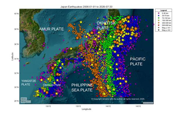
Our focus here is tectonic activity in the region, not magmatic activity (we do not have access to the data for the latter). We looked at the area 39°N,133.5°E to 30°N, 147°E from 1st January 2006 to 24th August 2026.
Our plots show the dominance of the subduction of the Pacific Plate in the area. In the geoscatter plot we can also just about see the triple junction near Mount Fuji delineated in shallow (purple) earthquakes.
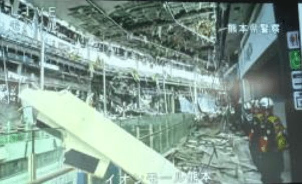
What we cannot see clearly in any of our plots is the subduction of the Philippine Sea Plate; however, this is visible in our plot of the area to the west, 39.63°N, 153.14°E to 28.60°N, 124.75°E, where we can see subduction under the Okinawa Plate (Shallow 6.8 magnitude Earthquake South of Kumamoto, Japan, 28th July 2026). This implies that the Philippine Sea Plate may not subduct under the Amur Plate but has a different type of boundary, which may. or may not. contribute to the basaltic magmas of Mount Fuji, or the subduction is aseismic – something we will look into at a future date.

Armchair Volcanologist
© Copyright remains with the author, all rights reserved, 2026.
Sources
USGS for raw earthquake data: Earthquake Hazards Program | U.S. Geological Survey
Yamamoto, T., Nakano, S. & Ishizuka, Y. Temporal variations of magma composition, eruption style and rate at Fuji Volcano, Japan. Earth Planets Space 73, 169 (2021). https://doi.org/10.1186/s40623-021-01505-1
Yosuke Aokia, Kae Tsunematsu , Mitsuhiro Yoshimoto, Recent progress of geophysical and geological studies of Mt. Fuji Volcano, Japan, Earth-Science Reviews
Volume 194, July 2019, Pages 264-282. https://doi.org/10.1016/j.earscirev.2019.05.003
Yamamoto, T., Nakada, S., Extreme Volcanic Risks 2: Mount Fuji, Volcanic Hazards, Risks and Disasters, 2015, Chapter 14, ISBN 978-0-12-396453-3
Wikipedia: Mount Fuji – Wikipedia
Global Volcanism Program, 2026. Fujisan (283030) in [Database] Volcanoes of the World (v. 5.4.0; 7 Aug 2026). Distributed by Smithsonian Institution, compiled by Venzke, E. https://doi.org/10.5479/si.GVP.VOTW5-2026.5.4 . Specific link to Fujisan: Global Volcanism Program | Fujisan
Wikipedia: Tokyo – Wikipedia