The Icelandic Met Office (IMO) has updated the aviation alert for Grímsvötn from green to yellow today (30.09.2020) because the volcano’s activity is above background level, now at a level comparable to that which preceded previous eruptions. They note:
Above average seismicity for September 2020;
Deepening cauldrons in the ice-cap round the caldera from geothermal activity;
Surface deformation exceeding that which preceded the 2011 eruption;
Magmatic gases detected in the summer of 2020.
An eruption is not considered imminent.
Water levels in the sub-glacial lake are high indicating possible jökulhlaups in the coming months. Draining of the lake by a jökulhlaup depressurised the system before the 2011 eruption, so an eruption is considered possible in the event of a jökulhlaup.
Activity may decrease without an eruption in this instance; only time will tell.
Jumping the gun a bit on our next post in the volcanic risk mitigation series, the IMO’s alert is an example of using alert levels to highlight the increased risk of an eruption to those who need to know, without being unduly alarmist – a straightforward statement of the facts supporting the current status. For the exact wording of the alert, please follow the link below.
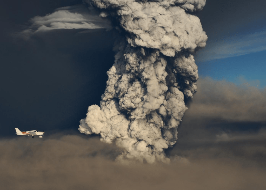
Fig 1: Eruption column 3 hours after the onset of the 2011 eruption of Grímsvötn. Source: Sigurjónsson, O. (2011 May 21). Grímsvötn: photo 10 of 14. Retrieved from http://icelandicvolcanoes.is/?volcano=GRV
Grímsvötn is located under the Vatnajökull ice-cap in an active rift zone of the Eastern Volcanic Zone, Iceland. She erupts frequently; her last in 2011 was a large VEI 4, which impacted local farmers and livestock and aviation in Europe.
Update (02/10/2020)
Googling around a bit more, I note that Iceland’s Department of Civil Protection and Emergency Management, Almannavarnir, have reported in their 25 September 2020 bulletin that an eruption is considered likely this Autumn (use Google Translate or other tool, if you need to, as it is in Icelandic).
Our second part of our series on Volcanic Risk Mitigation covers understanding the hazards and risk posed by our own volcano.
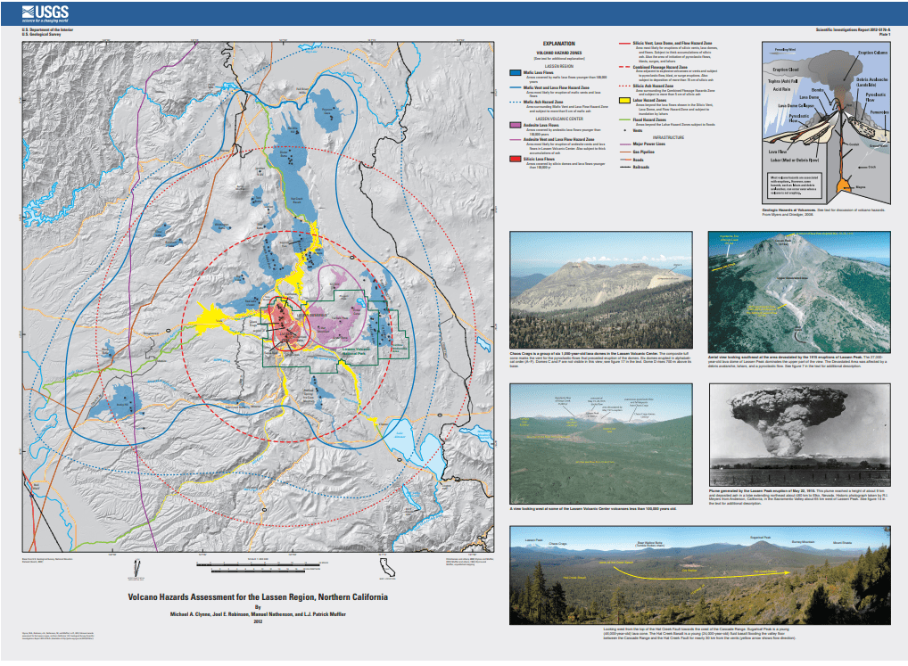
Fig 1: Lassen Peak Hazard Map, USGS, Public Domain (for full reference see Sources below). Coloured blocks indicate lava flows (mafic blue, andesite purple, silicic red) and lahars (yellow). Circles denote the extent of ash. Black dots are vents. Flood risk is also shown
Understanding our volcano is a vital part of volcanic risk mitigation. If we don’t understand our volcano and what it can do, we may not take the right action at the right time – we may call for an evacuation too soon; we may not call for an evacuation when needed; or, we may evacuate to the wrong place. If we get it wrong, the cost and disruption will be huge, and, there may be considerable preventable loss of life. We really don’t want to be at ground zero at the wrong time.
Who Needs to Know
Everyone who is likely to be impacted: the volcanologists, local authorities (government, civil defence authorities, public officials), and the general public (business, including aviation, other organisations and individuals). The following shows our roles, based on a summary published by USGS.
The volcanologists monitor volcanic activity, issue warnings to the local authorities of impending eruptions, participate in development of volcano coordination plans, and deliver eruption updates via a formalised communication protocol.
The local authorities (civil defence) develop emergency plans, provide information about local hazards and emergency procedures, and during volcanic activity, they advise residents about closures, exclusion zones, evacuation routes, and recommendations for recovery. Meteorological agencies issue volcanic ash alerts for aviation.
The public can help themselves to remain safe by learning about the hazards where they live or visit, following local recommendations to ensure households and businesses are prepared, including being able to evacuate at what could be relatively short notice (making an emergency plan and compiling an emergency kit (the essentials, like medications, that you can grab and go on the way out of the house)), and keeping out of exclusion zones.
What Can Go Wrong? Armero, 1985
Failure to understand hazards by decision makers has led to some of the worst volcanic disasters in recent history; for example, the loss of Armero and its 23,000 inhabitants from a lahar in the 1985 eruption of Nevado del Ruiz. The disaster, itself, unfolded as follows on 13 November 1985: at 15:05 a phreatic eruption started at the summit; 16:00 the local geological survey recommended evacuation of Armero; 17:00 the emergency committee met for a couple of hours (the outcome was indecisive); 19:30 the Red Cross issued an evacuation order, apparently not heeded; 21:08 the main eruption started; 22:30 an alert of an avalanche approaching Armero was issued, however, the local mayor ordered residents to stay at home; 23:35 the first lahar swept through the town, destroying it and its inhabitants.
The eruption of Nevado del Ruiz was not unexpected. There were precursors: heavy steaming occurred at the summit in November 1984; a phreatic eruption in February 1985 caused ashfall on a nearby town and a lahar that reached 27km from the volcano; earthquake swarms started on 7 November 1985 and the volcanic tremor set in by 10 November – both indicating magma was ascending.
It was known that Armero had been destroyed by lahars in 1595 and 1845, so why would the local authorities delay evacuation or be slow to order it? In addition to failure to comprehend the size, destructive power and possible reach of a lahar, the simple answers are cost, social and economic disruption, and no-one wants loss of credibility from crying wolf. An evacuation is costly in terms of moving people, providing shelter and loss of incomes.
The tragedy of Armero has led to the establishment of protocols to be followed in the event of a volcanic incident; in this instance, lessons were learned. One of the big lessons was helping local authorities and local populations understand the hazards / risks their volcano posed. Educational programmes, systems of alert levels and response protocols have been developed.
What Do We Need to Know?
To predict what our volcano may do we need to know what similar volcanoes and our volcano have done in the past. We then need to look at the impact of any eruptive activity on the local area in terms of how the following will be affected: the local inhabitants, property, the local infrastructure, farming and other economic activity.
We also need to know what baseline level of activity is so that any unusual activity which may herald an eruption is picked up early.
The Boring Bit – Definitions
We’ll get this over with quickly. The important bit is that calculating risk for hazards by location helps planners work out mitigation plans later.
A volcanic hazard is defined here as a natural process that has caused loss at a particular volcano in the past for which, based on its history, a probability can be calculated. Risk is the potential loss from a potential hazard, including loss of life, damage to property, reduction in productive capacity of the region and destruction of land, crops and habitats. Risk is used to determine, for example, the size of exclusion zones and evacuation orders. There is a formula to calculate risk:
Risk = value x vulnerability x probability of hazard.
Where value is the number of threatened assets (lives, property, farming, other commercial activity and infrastructure). Vulnerability is percentage value likely to be lost in an eruption.
Note: this formula is based on the volcano’s known history. It is a good place to start. But it has to be borne in mind that the volcano may change its behaviour so be prepared to update the risk evaluation as we get more information.
What the Volcano is Likely to Do
What type of volcano is it?
Knowing the type of volcano, its geological setting and its lavas indicates how it is likely to erupt. Our volcano is more likely to behave like others of its type in a similar geological setting than not. A shield volcano with basaltic lavas is more likely to have effusive eruptions rather than explosive eruptions. A stratovolcano or composite volcano with more viscous silicic lavas is more likely to have more explosive eruptions. Glacier, ice-caps or high rainfall may cause lahars or jökulhlaups. Proximity to large inland bodies of water or the ocean adds the risk of tsunamis.
What has the volcano has done in the past?
So we know what type our volcano is, its lavas and what similar volcanoes have done, which give some indicators of what it could do. But what has it done so far? How big have its previous eruptions been, how far did the ash travel, what precursors have there been, etc.?
Volcanologists check out the volcano’s eruptive history by looking at both historic records and the local geology. Historic records may indicate what the precursors for an eruption were, such as gas or steam emissions and earthquakes, as well as the eruptions themselves. Geological records, such as tephra layers (age, depth, composition) provide evidence of previous eruptive activity, e.g. pyroclastic flows , lahars, lava flows and lava compositions, and caldera formation. The geology can also tell us if there is ground water held in aquifers which could lead to phreatic eruptions.
Volcanologists may also check out the stability of the edifice: how quickly was it formed; what is it made of; what is it built on; and any evidence of faults.
Local Impact
Local government should have most of the data necessary to calculate the impact of a hazard at any one locations (local community, infrastructure and economic activity, etc.) from census and other activities. This should be checked out as far as is practical to make sure that it is up to date by looking at what is on the ground.
Hazard Mapping
With all this data, volcanologists calculate the volcanic risk for each hazard by geographic location using the formula above (a huge exercise, we are just skimming the surface here), collate their findings in reports and create hazard maps, which summarise the risk by location and by hazard (see Fig 1 for an example). These maps are an important means to share the risks with local civil defence authorities and will be part of the decision-making process regarding exclusion zones or evacuation plans, should our volcano stir.
Baseline levels of activity
Volcanoes in repose are not quiet; they have low levels of activity from minor internal movements of magma and degassing and tectonic movement of local faults, with associated low levels of seismicity, gas emissions, minor ground deformation (inflation and deflation).
We need to know what activity is usual for the volcano while it is in repose so that any unusual activity can be detected early. This will require seismometers, thermal imaging, tilt-meters, GPS, satellite and gas monitoring; seismometers are critical.
When Do We Need to Know It?
The short answer is the sooner the better. The geological surveys needed can take months. And, if we can get it, we need the base line data for the volcano in repose. On the other hand doing the hazard and risk assessments is costly so countries tend to focus on those volcanoes that pose most risk (e.g. are near large cities).
If the first inkling we have that our volcano is active is a seismic swarm and steam jets, the volcano is stirring so the hazard and risk assessments are critical. As time may not be on our side, we may need to call in experts from other countries to help out.
What is in Place Now?
It’s been a while since Armero, where are we now? Most countries with active volcanoes have the basics in place to monitor their known active volcanoes. The level of monitoring depends on the wealth of each country and the perceived risk those volcanoes pose. Some organisations, such as USGS and various universities, offer assistance in volcanic risk mitigation, which includes hazard identification, evaluation and mapping.
Following the Armero disaster, the International Association of Volcanology and Chemistry of the Earth’s Interior, IAVCEI, successfully created an educational video, “Understanding Volcanic Hazards”, to help decision makers and local people who had little awareness of what a volcano can do. Since then, with the advent of the internet, there is a wealth of educational material available to draw on. Many volcano monitoring organisations make some data publicly available.
There are various programs in place to study volcanic risk, including the Decade Volcano Program, set up by IAVCEI, the Yokohama strategy, the biennial Global Assessment of Risk (GAR) report published by the United Nations Office for Disaster Risk Reduction (UNISDR), the EU has also started major research programs dealing with risk assessment.
Data bases have been set up by various bodies describing volcanoes, their eruptive history and known hazards, such as the Global Volcano Model, the Smithsonian Institute’s Global Volcanism Program and Icelandic Volcanoes – the latter two have been referred to in this blog on many occasions.
Hopefully, we will know our volcano before she wakes up fully and be prepared for the crisis management mode if an eruption ensues.
All good books on volcanoes describe well-known eruptions, including Vesuvius 79 AD, Tambora 1815, Krakatau 1883, Mount Peleé 1902, Katla 1918, Mount St. Helens 1980, Pinatubo 1991. Who are we to be any different?
There is a good reason for this. Most famous eruptions are large and explosive, causing loss of life and considerable property damage – in other words, headline-grabbing. Later eruptions have impacted aviation – volcanic ash and jet engines are not a good mix; airports near erupting volcanoes are closed and flights re-routed to avoid the ash clouds.
Catastrophic events are the reason volcanology is such an important subject. Understanding these and other eruptions is important to find out how to minimise the risk; i.e. reduce loss of life.
Researchers have shown that volcanoes usually very kindly give us some warning in the lead up to an eruption. Magma is viscous, rarely moves fast and, when moving, causes earthquakes, usually small, but some are felt without equipment. As magma ascends, degassing starts to occur, some of which is detectable at the surface. Rising magma also causes ground deformation, e.g. it causes the volcano to inflate, measurable by tilt-meters and GPS, and some of which may even be visible to the naked eye (Mount St Helens).
I read somewhere that the first piece of equipment required to monitor a volcano is a seismometer, the second is another seismometer, as is the third; earthquakes are often the first sign of impending trouble (if I can remember / find the source, I will accredit it properly). Scientists observing volcanoes will have a raft of equipment in place: seismometers, GPS stations, tilt-meters and gas monitoring; satellite monitoring may also detect ground deformation. Drones may be used to inspect craters which are not readily accessible or where it would be unsafe to visit. Our maps of Iceland include some GPS stations as markers to indicate where the earthquakes are occurring but still evidence that Iceland has several in place at its active volcanoes.
Given that volcanoes give some warning, why are people killed? Unfortunately, magma ascent and the build up to an eruption is a slow process with many stops and starts. A major eruption may be preceded by a few small throat clearing events before the volcano unleashes the main eruption. An evacuation may take place, but if it is quiet between the precursors and the main event, people may think that the volcano has finished and return home to be at ground zero at the wrong time, irrespective of whether or not any alert is in place. People living close to volcanoes tend to be farmers with strong bonds to both their land and livestock. On the other hand, the volcano may not behave as expected – e.g. a phreatic eruption or edifice failure. Volcano hazard assessment is an interesting topic for future posts.
We will also look at some of the more famous eruptions over the coming weeks.