This is the first of out famous eruptions series. Why not start with one of the largest?

Tambora produced one of the largest known eruptions in recorded history with a climate impacting VEI 7 and possibly the largest Holocene eruption (other contenders for a VEI 7 being Kurile Lake, 6440 BC, Mazama, 5700 BC, Kikai Caldera, 4300 BC, Cerro Blanco, 2300 BC, Thera (Santorini), 1620 BC, Taupo, 180 AD, Baekdu, 946 AD, and Samalas (Rinjani), 1257 ).
Tambora’s once proud 4,300 m stratovolcano lost around a third of its height and acquired a 1 km deep, 6 km wide caldera over the space of a few days in April 1815. Sumbawa and the surrounding islands were devastated. Climate abnormalities (cooling and severe storms) were noted round the northern hemisphere along with crop failure and famine. Tambora is accredited as the cause of the 1816 “year without a summer”. The eruption released 50 km3 of magma, 150 km3 of tephra, 80 million tonnes of sulphur dioxide and 18 mega tonnes of fluorine, along with water vapour and other aerosols.
The eruption was chronicled by local eye witnesses. However, the then lieutenant governor of Java, Sir Stamford Raffles, keen to develop trade in the area, was not so keen to broadcast it further afield to potential investors; outside the region, the eruption went largely unnoticed by the West, already distracted by the Napoleonic wars.
Geological Setting
Before the eruption, Sumbawa Island was a pleasant prosperous island, trading mung beans, corn, rice, coffee, pepper, cotton, wood and horses. Despite a wealth of natural resources, the people to farm them were in short supply so there was also a large slave trade and piracy.
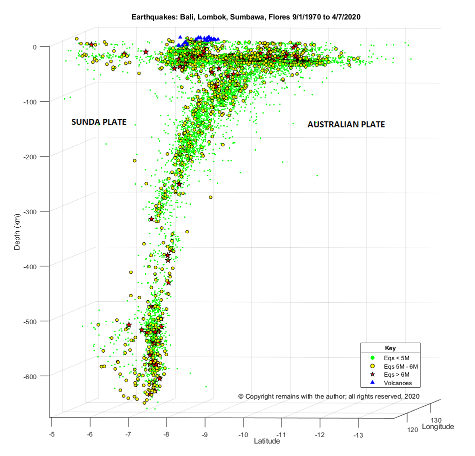
Tambora occupies the entire Sanggar Peninsula on Sumbawa Island in the Sunda Arc of the Indonesian Archipelago. Here the Australian Plate subducts beneath the Sunda Plate at a convergence rate of 7.8 cm per year. Plotting the earthquakes in the region for 1972 to date clearly shows the Wadati-Benioff zone, with volcanoes sitting around 70km above the descending plate.
Tambora is a 60 km wide stratovolcano with trachybasalt and trachyandesite lavas. She formed a caldera c.43,000 years ago which was in-filled by Pleistocene lava flows. During the Holocene her eruptions have been explosive: three eruptions in the Holocene occurred before the 1815 event, identified by radiocarbon dating, 740 AD, 3050 BC, and 3910 BC; three further smaller eruptions have been observed since the 1815 event, 1819 VEI 2, 1880 VEI 2 and 1967 VEI 0, which extruded lava domes and small lava flows on the caldera floor.
1815 eruption
Tambora had been dormant for over a thousand years; magma cooling and fractional crystallisation had been occurring along with the exsolving of high-pressure magma; over pressurisation was happening. Tambora awoke in 1812 with minor activity during the period 1812 to 1815 while magma ascended from the reservoir c.4 km below the edifice.
The 1815 eruption proper started with a short Plinian eruption on 5 April 1815 of trachyandesite, lasting two hours, producing a 33 km eruption column; the explosions were heard as far away as Sumatra and were confused with gun fire. Following this, between 5 April and 10 April, there was a relatively low level of activity.
On the evening of 10 April, a second short Plinian eruption occurred, lasting three hours, producing a 44 km eruption column. Pumice rained down on local villages for 2 hours. Volcanic winds destroyed trees and property. The eruption column collapsed as the vent was eroded. Pyroclastic density currents (PDCs) raged over the next three to four days, creating phoenix ash clouds, covering the area in ash and destroying villages, along with inhabitants. During this phase the volcano, no longer supported by magma, subsided, creating the current caldera.
Tsunamis were generated when the PDCs reached the sea. Sanggar was engulfed in a four-metre high tsunami at around 10 pm on 10 April; this tsunami reached Java a couple of hours later with a height of two metres.
Explosions were heard during the night of 10 to 11 April up to 2,600 km away. Locations within a 600km radius suffered darkness for a couple of days and a chilling of the atmosphere while sunlight was blocked.
Seven or more ignimbrite layers were deposited during the second phase of the eruption. Only 2.6 km3 of deposits remain on dry land; the heavier ejecta ended up in the sea and lighter aerosols were scattered round the globe. Pumice rafts up to 5 km wide and trees trunks littered the Flores Sea, providing a hazard for shipping for several months.
Eruptive activity continued intermittently up to August 1819.
Local and global impact of the eruption
Sumbawa was stripped of its vegetation. The death toll in Sumbawa and neighbouring Lombok was in the order of 60,000, 10,000 from the eruption itself with the remainder from disease and famine from polluted water and loss of crops and livestock. Children were sold into slavery in order for them to survive or apparently killed to avoid a slow death from starvation or worse.
The effects were also global. The volcano had lobbed 50 km3 of matter plus gases into the stratosphere. Larger particles fell back to Earth but smaller aerosols hung around for three years causing adverse weather phenomena (e.g. storms), global cooling, failed harvests, famine and disease in much of the northern hemisphere.
The global effects were exacerbated, according to ice-core sampling, by another large catastrophic eruption in 1809. The source for the 1809 has yet to be identified; the volcano and eye witnesses may not have survived the eruption. However, the 1809 and 1815 eruptions together caused a little ice age.
Can this happen again?
VEI 7 eruptions are rare. As mentioned earlier, there are currently only eight other contenders in the Holocene. That is not to say they won’t happen again in the future.
My guess is that to get another large event, not only do you need a large magma source and a build-up of pressure but also an element of edifice failure. The largest part of the Tambora eruption in terms of magma output was while the PDCs were in full swing; these occurred as or after the vent eroded. We will see in the accounts of other eruptions, there was some edifice failure.
In the meantime, Mount Tambora and her Indonesian sisters are well-monitored.
The Armchair Volcanologist
6 July 2020 (updated 23/08/2020 & 25/08/2020 to include more potential VEI 7s (the list is getting longer!)
© Copyright remains with the author; all rights reserved, 2020
Sources and Further Reading
“Volcanoes, Earthquakes and Tsunamis”, David A. Rothery, Teach Yourself, 2010.
“Volcanoes”, Second Edition, Peter Francis, Clive Oppenheimer, Oxford University Press, 2004
“Tambora: The Eruption That Changed the World”, Gillen D’Arcy Wood, Princeton University Press, 2014
Mount Tambora – Wikipedia, https://en.wikipedia.org/wiki/Mount_Tambora
Earthquake data from Incorporated Research Institutions for Seismology (IRIS) Earthquake Browser: http://ds.iris.edu/ieb
Plot by the author.
