Tag Archives: Krýsuvík Volcanic System

Update on the eruptions at Fagradalsfjall and La Soufrière St Vincent, and status of Mount Pelée

Good Afternoon!

Fig 1: Image from Civil Protection / Webcam 11.05.2021

Fagradalsfjall

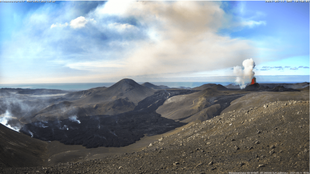
At the time of writing the eruption at Fagradalsfjall is not only continuing unabated but getting stronger.  After the opening of five new fissures, eruptive activity has focused on one crater, fissure 5. Lava now covers the Geldingadalur valley floor and threatens to engulf the first cones; lava has been flowing steadily into Meradalir since 24 April 2021.

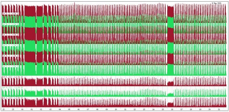
Eruptive activity changed from continuous fountaining with effusive lava flows to periodic jetting after midnight on 2 May 2021. The change is thought to be due to degassing of the magma in the upper part of the eruption channel where a small chamber may have formed.  Each jet is now accompanied by strong gas emissions.  Lava flow, itself, is mostly being carried in lava channels under the crater rim, rather than ejected in the current jets so periodic jetting has not adversely impacted the output.

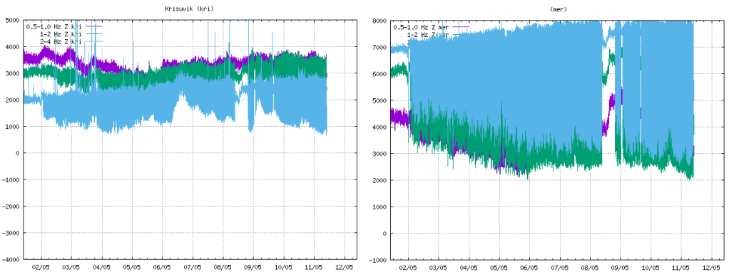
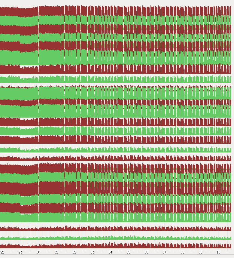
The onset of jetting can be seen in the tremor plots from local stations. We have included KRI because, being further away, we can see more of the lower frequency lines.

Fig 2: Tremor plots for KRI and MER showing the onset of jetting on 02 May 2021. Source: IMO
Fig 3: Unrest seen on seismometers near the eruption sites with pulses in volcanic activity from midnight on 2 May 2021.  Source: IMO
Fig 4: This image shows the unrest on days 8-9. May. Source:  IMO

Some stats as at 10 May 2021 (Source: Institute of Earth Sciences (hi.is))

  • Area of the Geldingadalsgos lava field: 1.78 Km2 (1.41Km2, 03 May 2021)
  • Volume of erupted lava: 30.7 million m3 (23.0 million m3, 03 May 2021)
  • Lava discharge rate: 12.9m3/s, (7.5m3/s, 03 May 2021)
  • Mg0: varies from 8.5 to 9.8
  • K20/Ti202 ratio: increasing from 0.1 to 0.3

In the first two weeks of the eruption lava flow decreased steadily from 7-8m3/s to 4-5m3/s.  In the second two weeks, five new fissures opened with lava flow varying between 5 – 8m3/s.  In the two weeks to 3 May 2021, one crater dominated with lava flow increasing.  In the week to 10 May 2021, there has been a large increase in the output of lava to 12.9m3/s; the lava field now covers an area of 1.78km2 with a volume of 30.7 million m3.  It is thought that the increase in output reflects changes in the lava channel from the mantle to the surface; it has widened over time.

Changes in chemical composition may mean that materials are mixing in the upper mantle before ascent or there is less partial mantle melt in the magma.  If the latter, the eruption will end when the mantle source is sufficiently reduced.

Geldingadalsgos is still a toddler compared to Holuhraun; Geldingadalsgos’ eruption rate is 5% – 10% of the average eruption rate at Holuhraun between September 2014 and February 2015. Let’s hope it stays that way as it is a lot closer to residential areas.

La Soufrière St. Vincent

The alert status was lowered to orange after a period of relative quiescence on 6 May 2021; only a few long period events and volcano-tectonic earthquakes are occurring each day.  People are allowed back into the orange zone but the red zone remains an exclusion zone.

The last explosive event was on 22 April 2021.  However, a possible lava spine was spotted on photos on 27 April 2021.  Tephra fills the crater, increasing the risk of pyroclastic flows should eruptive activity pick up again.  In the meantime, lahars are the main hazard.

Mount Pelée

Mount Pelée remains on alert level yellow.  Volcano tectonic events are occurring and seismic activity remains at above baseline level.  An area of brown and dead vegetation was confirmed on 8 February 2021 caused by diffuse CO2 emissions; the vegetation has not recovered.   The volcano is slowly reawakening.

Armchair Volcanologist

© Copyright remains with the author; all rights reserved, 2021.

Sources and Further Reading:

In the text and:

Iceland

Icelandic Met Office: https://en.vedur.is/ (English site)

Icelandic Met Office: https:// vedur.is/ (Icelandic site)

Reykjavik Grapevine: https://grapevine.is/

Department of Civil Protection and Emergency Management | Almannavarnir

La Soufrière St. Vincent

St Vincent and the Grenadines:  https://news784.com/

Barbados: https://www.nationnews.com/

Mt Pelée

Observatoire volcanologique et sismologique de Martinique (OVSM – IPGP): http://www.ipgp.fr/fr/ovsm/observatoire-volcanologique-sismologique-de-martinique-ovsm-ipgp

Update on the Ongoing Earthquake Swarm on the Reykjanes Peninsula

14.03.2021: The magma intrusion on the Reykjanes Peninsula appears to be edging further southward. The longer this continues, the more likely an eruption.  New plots added (Figs 13 – 15).

Update 14.03.2021

We have moved updates to the beginning of this post. The original post from 9 March 2021 and the earlier update are below.

We have updated our plots to 14.03.2021 17:46 for the area between 63.83314°N, 22.55148°W to 63.96605°N, 21.8566°W .  Here are the results; the magma intrusion appears to be edging slowly further southwards, if we use the Department of Civil Protection’s line that the earthquake locations are the best indicator at the moment of where the magma is.

Fig 13:  Geodensity plot by the author of earthquakes occurring between 63.83314°N, 22.55148°W to 63.96605°N, 21.8566°W from 24.02.21 to 14.03.21. Earthquakes over 5M are shown. © Copyright remains with the author; all rights reserved, 2021.
Fig 14: Geoscatter plot by the author of the of earthquakes occurring between 63.83314°N, 22.55148°W to 63.96605°N, 21.8566°W from 24.02.21 to 14.03.21. © Copyright remains with the author; all rights reserved, 2021
Fig 15: Depth v Latitude scatter plot by the author of the of earthquakes occurring between 63.83314°N, 22.55148°W to 63.96605°N, 21.8566°W from 24.02.21 to 14.03.21.  © Copyright remains with the author; all rights reserved, 2021

For the current status and advice, please consult IMO.

The Armchair Volcanologist

Update 12.03.2021

Since we wrote [our original post], the earthquake swarm continues unabated with several thousand more earthquakes and some more tremor pulses.

The Department of Civil Protection report today includes the following:

“Earthquake activity now reaches up to the Nátthagi valley south of Fagradalsfjall, which suggests that the southernmost end of the magma path lies there.  

The magma path continues to expand although there is some uncertainty regarding the pace of the magma flow. Data has indicated that the magma path has been moving towards the south coast in the last few days, but latest surveys do not indicate that the path has moved notably in the last 24 hours. 

With view of the eruption history and geological research, a volcanic fissure opening south of Fagradalsfjall and reaching the ocean is unlikely. Given the current circumstances, an undersea eruption with associated ash eruption is therefore unlikely.     

As has been stated earlier in the Science Board’s notifications, while the magma path continues to expand it must be assumed that an eruption may occur in the area. The longer the current situation lasts, the more likely an eruption becomes. “

They also note that gas measurements are being taken in the area.

Our updated plots show the seismic activity moving further southward, notably the geodensity plot in Fig 12.  There is also some parallel activity further west on a much smaller scale.

Fig 9: Geoscatter plot by the author of earthquake occurring on the Reykjanes Peninsula between 22.02.21 to 12.03.21.  © Copyright remains with the author; all rights reserved, 2021.
Fig 10: Geoscatter plot by the author of the of earthquakes occurring between 63.83314°N, 22.55148°W to 63.96605°N, 21.8566°W from 22.02.21 to 12.03.21. © Copyright remains with the author; all rights reserved, 2021.
Fig 11: Depth v Longitude & Latitude scatter plot by the author of earthquakes occurring between 63.83314°N, 22.55148°W to 63.96605°N, 21.8566°W from 22.02.21 to 12.03.21.  © Copyright remains with the author; all rights reserved, 2021.
Fig 12: Geodensity plot by the author of earthquakes occurring between 63.83314°N, 22.55148°W to 63.96605°N, 21.8566°W from 22.02.21 to 12.03.21. © Copyright remains with the author; all rights reserved, 2021.

For the current status and advice, please consult IMO.

The Armchair Volcanologist

09.03.2021

An eruption considered likely; magma c. 1km below the surface.

Good Afternoon!

Despite the earlier tremor pulses, the Krýsuvík Volcanic System has not yet erupted.  However, as seismicity continues to be intense, with well over 34,000 earthquakes recorded by Iceland’s SIL system now since 24 February 2021, it is thought that an eruption is likely. 

The latest report from Iceland’s Civil Protection Service Council on March 8, 2021, states that if an eruption occurs, the most likely scenario is still a fissure eruption between Fagradalsfjall and Keilir.  A magma intrusion (they use the term tunnel) is forming in the region, with most recent activity at its southern end.  Magma has now reached an upper depth of c. 1 km.  GPS and satellite readings indicate that the magma flow has decreased in the past week.  If the intrusion continues to grow, further surges in seismic activity can be expected.

The earthquakes trending westward from the vicinity of the magma intrusion are thought to be the result of the crust accommodating the intrusion.  No other magma movement has been detected during this swarm. 

So where are Fagradalsfjall and Keilir?  Here is a map (with directions on how to drive from one to the other, not that we would recommend that at the moment).

Fig 1: Extract from Google Maps showing the location of Fagradalsfjall and Keilir.

We have plotted the confirmed earthquakes for week 8 and week 9 2021, plus a few hours of yesterday, between 63.7°N, 21.0°W to 64.4°N, 23.0°W download from IMO’s site.  Here are the latest plots for the Reykjanes Peninsula, 63.7°N, 21.0°W to 64.4°N, 23.0°W:

Fig 2: Geodensity plot by the author of earthquake occurring on the Reykjanes Peninsula between 22.02.21 to 08.03.21 16:00.  © Copyright remains with the author; all rights reserved, 2021.
Fig 3: Geoscatter plot by the author of earthquake occurring on the Reykjanes Peninsula between 22.02.21 to 08.03.21 16:00.  © Copyright remains with the author; all rights reserved, 2021.

If we zoom in on the area between 63.83314°N, 22.55148°W to 63.96605°N, 21.8566°W we can take a closer look at the intrusion, itself, (or the earthquakes magma movement is causing).  The area was selected to take in Svartsengi, Fagradalsfjall, Keilir and Krýsuvík.

Fig 4: Geoscatter plot by the author of the of earthquakes occurring between 63.83314°N, 22.55148°W to 63.96605°N, 21.8566°W from 22.02.21 to 08.03.21 16:00.  © Copyright remains with the author; all rights reserved, 2021.
Fig 5: Depth v Longitude scatter plot by the author of earthquakes occurring between 63.83314°N, 22.55148°W to 63.96605°N, 21.8566°W from 22.02.21 to 08.03.21 16:00.  © Copyright remains with the author; all rights reserved, 2021.
Fig 6: Depth v Longitude & Latitude scatter plot by the author of earthquakes occurring between 63.83314°N, 22.55148°W to 63.96605°N, 21.8566°W from 22.02.21 to 08.03.21 16:00.  © Copyright remains with the author; all rights reserved, 2021.
Fig 7: Geodensity  plot by the author of earthquakes occurring between 63.83314°N, 22.55148°W to 63.96605°N, 21.8566°W from 22.02.21 to 08.03.21 16:00.  © Copyright remains with the author; all rights reserved, 2021.

Since we downloaded the data for the above plots, IMO have reported another short-lived burst in seismic activity at 05:20 this morning with a seismic tremor Mt. Fagradalsfjall, south of the intrusion.

IMO have produced a map of the dike intrusion and the areas of seismic activity that are arising due to the increased tension in the crust caused by the intrusion.

Fig 8: Map by the Icelandic Met Office showing the dike intrusion and the areas of stress.

For the current status and advice, please consult IMO.

The Armchair Volcanologist

© Copyright remains with the author; all rights reserved, 2021.

Sources:

Icelandic Meteorological Office (IMO): https://en.vedur.is/

Map in Fig 8: https://en.vedur.is/about-imo/news/earthquake-swarm-in-reykjanes-peninsula

Department of Civil Protection: Vísbendingar að kvikugangurinn liggi suður af Fagradalsfjalli  (Scroll down the page for the English version).