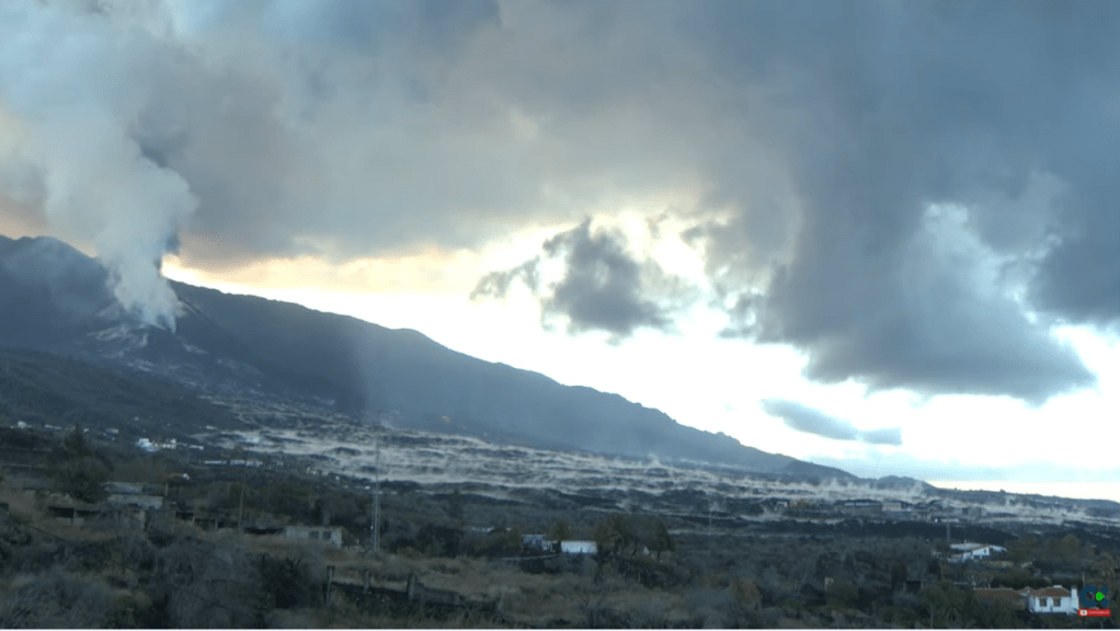
The eruption of Cumbre Vieja continues unabated with Strombolian activity, lava fountains from many vents, lava flows, and ash emissions. . As of 16 November 2021, Copernicus reported that 1,042.1 hectares of land have been covered by lava. Rainfall now adds to the hazards created by volcanic ash. The cone reached a height of 1,130m by 10 November 2021. Sadly, one fatality has occurred; one person who had gone to assist with ash clearance was found dead in his home.
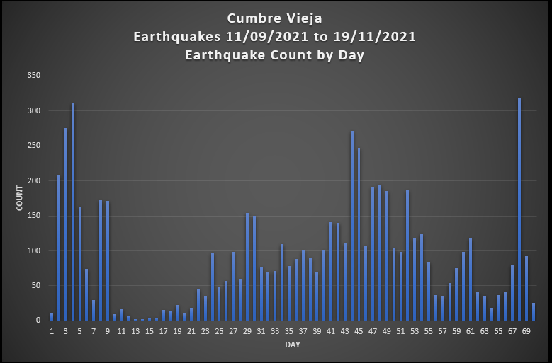
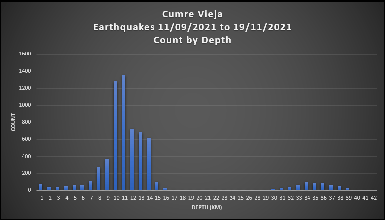
Here are updated earthquake plots. All of the action is centred around two depths: 7 -16 km and 30 -39 km, with a very few earthquakes in between; there are a few earthquakes with depths of more than 39 km.
For the updated video, we have provided the scatter plots for only earthquakes greater than or equal to 3.0 Mag. because the smaller earthquakes obscure the action; all earthquakes are included in the geoscatter plots.
Magma still appears to be stalling at the two depths: 7 -16 km and 30 -39 km prior to ascent (refer to La Palma: Earthquakes and Magma Plumbing for more information). How much of it reaches the surface remains to be seen.
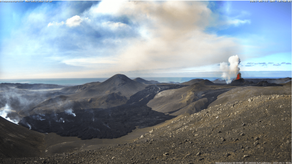
At the time of writing the eruption at Fagradalsfjall is not only continuing unabated but getting stronger. After the opening of five new fissures, eruptive activity has focused on one crater, fissure 5. Lava now covers the Geldingadalur valley floor and threatens to engulf the first cones; lava has been flowing steadily into Meradalir since 24 April 2021.
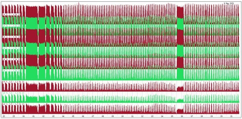
Eruptive activity changed from continuous fountaining with effusive lava flows to periodic jetting after midnight on 2 May 2021. The change is thought to be due to degassing of the magma in the upper part of the eruption channel where a small chamber may have formed. Each jet is now accompanied by strong gas emissions. Lava flow, itself, is mostly being carried in lava channels under the crater rim, rather than ejected in the current jets so periodic jetting has not adversely impacted the output.
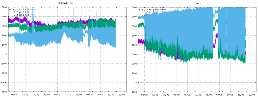
The onset of jetting can be seen in the tremor plots from local stations. We have included KRI because, being further away, we can see more of the lower frequency lines.
Fig 2: Tremor plots for KRI and MER showing the onset of jetting on 02 May 2021. Source: IMO
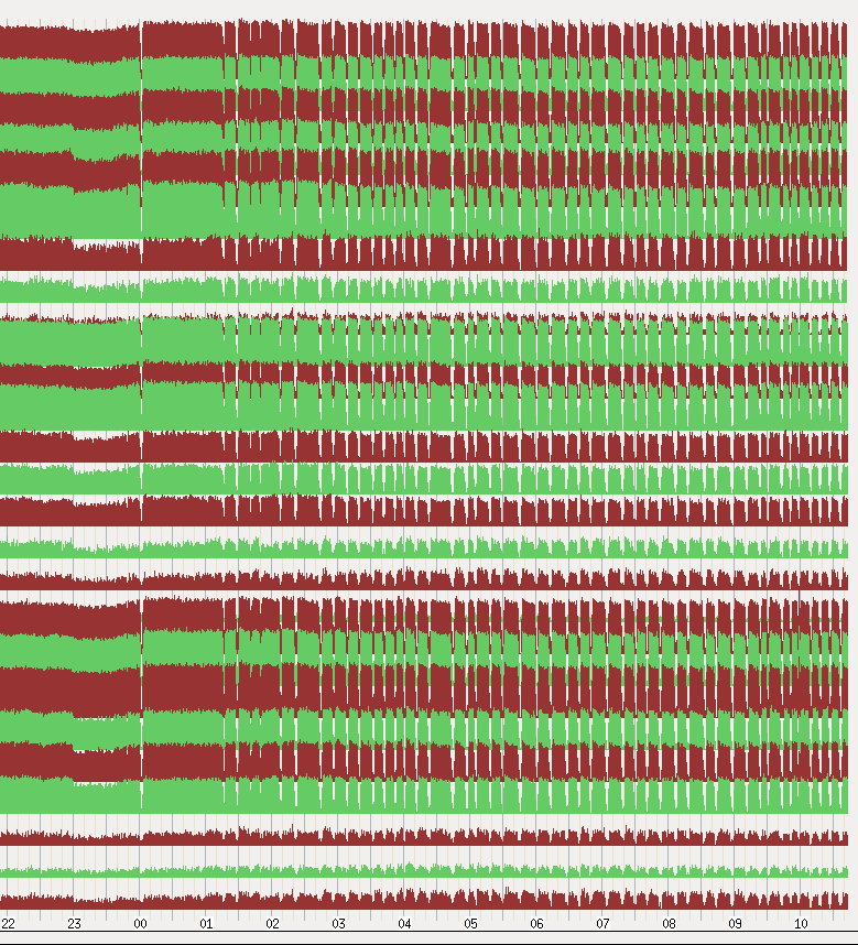
Fig 3: Unrest seen on seismometers near the eruption sites with pulses in volcanic activity from midnight on 2 May 2021. Source: IMO
Fig 4: This image shows the unrest on days 8-9. May. Source: IMO
Area of the Geldingadalsgos lava field: 1.78 Km2 (1.41Km2, 03 May 2021)
Volume of erupted lava: 30.7 million m3 (23.0 million m3, 03 May 2021)
Lava discharge rate: 12.9m3/s, (7.5m3/s, 03 May 2021)
Mg0: varies from 8.5 to 9.8
K20/Ti202 ratio: increasing from 0.1 to 0.3
In the first two weeks of the eruption lava flow decreased steadily from 7-8m3/s to 4-5m3/s. In the second two weeks, five new fissures opened with lava flow varying between 5 – 8m3/s. In the two weeks to 3 May 2021, one crater dominated with lava flow increasing. In the week to 10 May 2021, there has been a large increase in the output of lava to 12.9m3/s; the lava field now covers an area of 1.78km2 with a volume of 30.7 million m3. It is thought that the increase in output reflects changes in the lava channel from the mantle to the surface; it has widened over time.
Changes in chemical composition may mean that materials are mixing in the upper mantle before ascent or there is less partial mantle melt in the magma. If the latter, the eruption will end when the mantle source is sufficiently reduced.
Geldingadalsgos is still a toddler compared to Holuhraun; Geldingadalsgos’ eruption rate is 5% – 10% of the average eruption rate at Holuhraun between September 2014 and February 2015. Let’s hope it stays that way as it is a lot closer to residential areas.
La Soufrière St. Vincent
The alert status was lowered to orange after a period of relative quiescence on 6 May 2021; only a few long period events and volcano-tectonic earthquakes are occurring each day. People are allowed back into the orange zone but the red zone remains an exclusion zone.
The last explosive event was on 22 April 2021. However, a possible lava spine was spotted on photos on 27 April 2021. Tephra fills the crater, increasing the risk of pyroclastic flows should eruptive activity pick up again. In the meantime, lahars are the main hazard.
Mount Pelée
Mount Pelée remains on alert level yellow. Volcano tectonic events are occurring and seismic activity remains at above baseline level. An area of brown and dead vegetation was confirmed on 8 February 2021 caused by diffuse CO2 emissions; the vegetation has not recovered. The volcano is slowly reawakening.