27 March 2021
Good Morning!
The eruption at Geldingalur, Reykjanes, Iceland, which started on 19.03.2021 at 20:25, is continuing unabated as I write. The volcano is happily bubbling away building somewhat unstable but impressive looking cones and covering the Geldingadalur valley floor with lava.

The eruption is steadily increasing at the time of writing; it has a lava output of 5 -7m3 per second. IMO have estimated that the valley would fill enough for lava to overflow into the neighbouring valley, Meradalir, in a matter of days at the current eruption rates.

Scientists at the University of Iceland are analysing the lava. To date, they have reported that the lava is a primitive one (i.e. little magma evolution in the crust), indicative of a mantle source at a depth of 17 km to 20 km.
Geological Setting
The Reykjanes Peninsula lies on oceanic crust created by the Mid Atlantic Ridge. The Peninsula, itself, straddles the Ridge. The crust here is 15 km thick, which is unusual so close to a spreading ridge. However, Iceland is a basaltic plateau overriding a mantle plume. Both the mantle plume and the Mid Atlantic Ridge influence formation of the crust. There are no magma chambers / reservoirs in the crust on the Peninsula; magma tends to ascend directly from the mantle.
The Peninsula is made up of lava shields, móberg hills, table mountains and fissure-fed lava flows and crater rows. The shield volcanoes on the Peninsula formed at the beginning of the Holocene between 10,000 and 7,000 years ago. Shield volcanoes form from hot picrite or olivine tholeiitic basaltic lava flows with rates of c . 5m3 per second. The móberg hills formed from submarine fissure eruptions and consist of pillow lavas, breccias and tuffs. The table mountains were formed from subglacial activity, which had the activity not been constrained by the ice cap, would have resulted in shields. Later Holocene activity has comprised effusive tholeiitic fissure eruptions which formed crater rows and produced large lava flows that now cover some of the earlier formations. Historic activity has been between 940 AD and 1340 AD, including the Reykjanes Fires of 1210 AD to 1240 AD; and, the Krýsuvík Fires of 1151 AD to 1188 AD.
Geldingadalur, itself, is a small valley to the south east of the summit of Fagradalsfjall, a 385m high hyaloclastite subglacial Pleistocene table mountain formed during the Weichselian glacial period, with a subaerial lava cap on its northwest part. It is currently classified as part of the Krýsuvík Volcanic System.
The Fagradalsfjall area is seismically very active, with large earthquake swarms, notably in 1998, 2000, and 2004, and again now as part of the new volcano-tectonic episode on the Reykjanes Peninsula that started in December 2019. Various studies from previous seismic activity have noted extensive faulting under the south west part of Fagradalsfjall; these faults strike N-S and NE -SW. In addition, there are two clusters of faults under the eastern part.
Earlier swarms in the current volcano-tectonic episode have resulted in magma intrusions, such as the one at Mt Þorbjörn which we discussed last year, but no eruption. The latest earthquake swarm which started on 22 February 2021 is the only one to result in an eruption at the time of writing.
Seismicity in the Current Swarm
We have updated our plots for the Reykjanes Peninsula and dividing them between the run up to the eruption on 19 March 2021 at 20:45 and after the eruption to 26 March 2021 15:55.
The plots preceding the eruption repeat the ones shown earlier so we are just showing the geodensity plot for comparison. You will note that the earthquakes do not reach down to 15 km in the current swarm to date. However, there were one or two deeper earthquake in some of the earlier episodes.
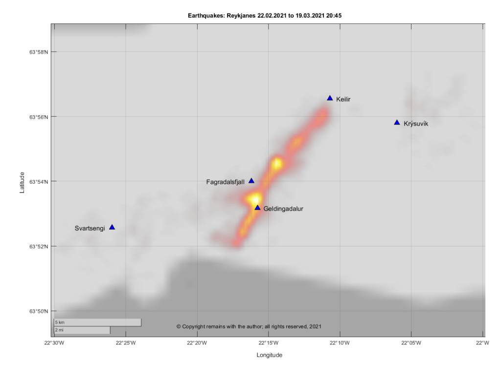
The plots for the period after the onset of the eruption (19.03.2021 20:45 to 26.03.2021 15.55) show that activity is concentrated on Geldingadalur and two spots north east of Fagradalsjall. Seismic activity has also extended further south.


Whether the earthquake hotspots will lead to new eruption sites, only time will tell.
For the current status, please consult IMO (link below).
If you wish to watch the eruption , there are local webcams. The link to one is given below.
The Armchair Volcanologist
© Copyright remains with the author; all rights reserved, 2021.
Sources:
Earthquake raw data: IMO: https://en.vedur.is/
Status reports: https://en.vedur.is/
Webcam link
