Tag Archives: lithosphere

The Magic of Magma

Good Afternoon!

Magma is the molten source of many of the rocks at the Earth’s surface; the others come from meteorites or other terrestrial processes.  Here, we look at how magma is generated and how it affects volcanic eruptions.   This is a long one; you may want to dip into it as a reference rather than read it all in one go, but bear with me.

Fig 1: Holuhraun on 4 September 2014 by peterhartree.  Published under CC BY-SA 2.0. Note the fire fountains, effusive lava flows and gas emissions.

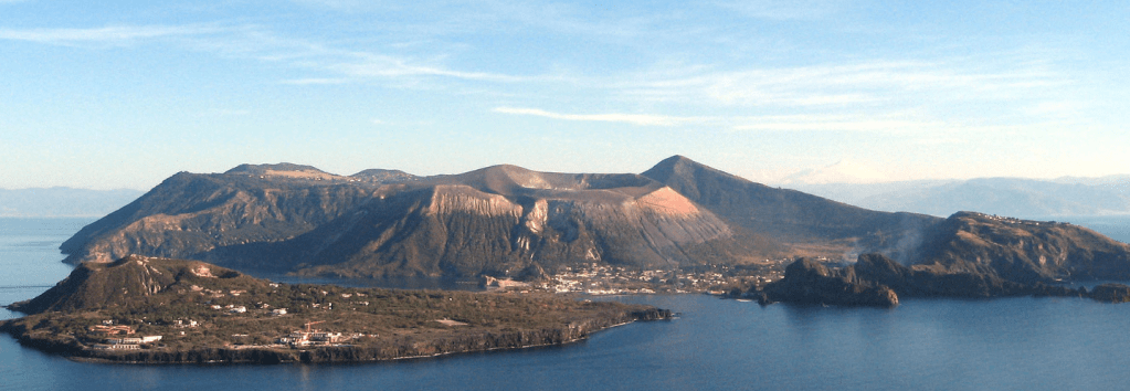
There are several different types of volcanic eruption, varying from effusive to explosive.  The type is determined by the magma composition- both its silica content and its volatile (gas) content.

How is magma generated?

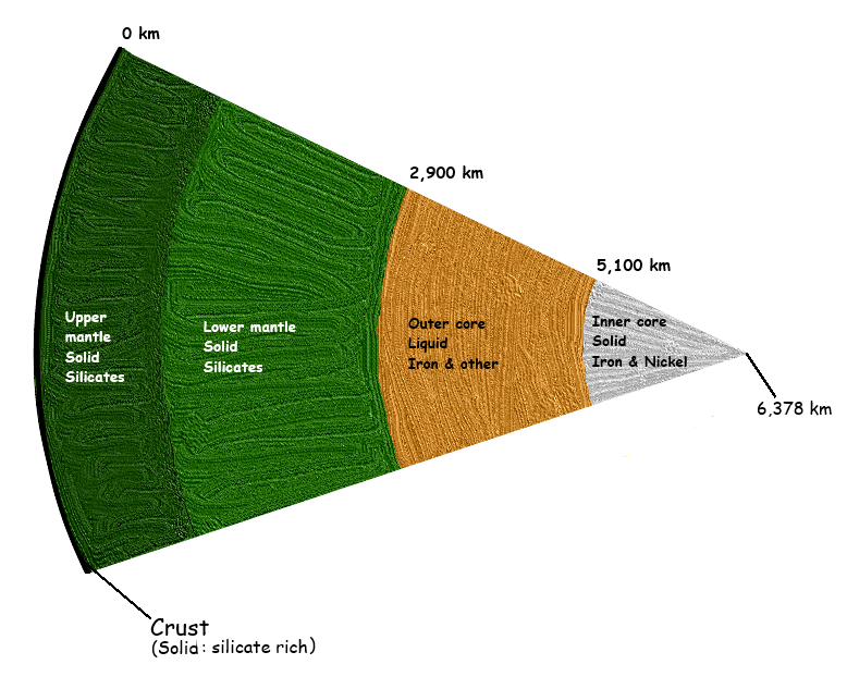
From our earlier post, we know that the heat required to generate magma comes from nuclear reactions at the Earth’s core.  This heat makes its way to the surface via conduction, convection and radiation.  The surface rocks are cold enough to be solid.  However, we saw that the heat from the core drives plate tectonics; it is the variations in temperature and pressure caused by plate motion, combined with changes in rock composition, that create the conditions for rocks to melt and create magma.

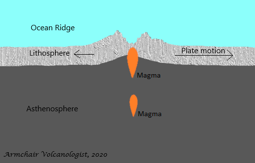
Effusive Continental Rifts / Ocean Ridges

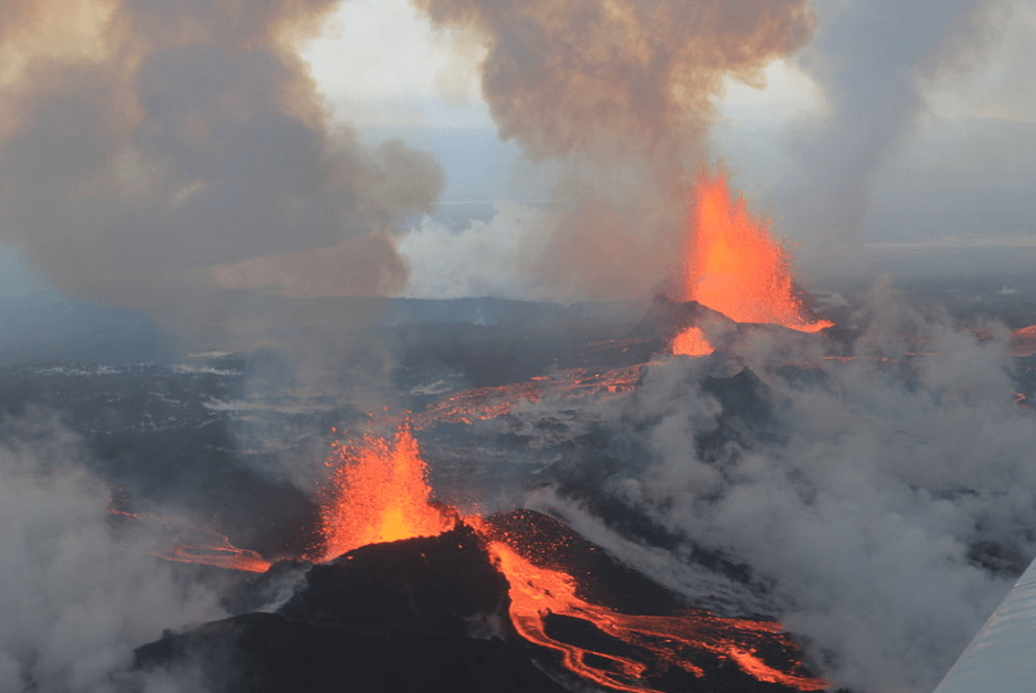
Effusive eruptions (think Hawaiian eruptions such as Kilauea) tend to occur at rifts or fissures, cracks in the Earth’s crust that let magma reach the surface relatively quickly and allow gases to escape gently.  Such fissures are common at constructive plate boundaries (continental rifts or mid ocean ridges), caused by plate separation.  Magma is generated in a process called decompression melting; as the plates move apart the overlying pressure is reduced, which in turn reduces the melting temperature of the mantle.  Because magma ascends relatively rapidly there is less time for it to mix with other magma or the crust.  This magma tends to be basic basalt. 

Magma ascent at ocean ridge
Fig 2:  Magma ascending at a Mid Ocean Ridge by the author after the many examples available.  Arrows denote plate motion.  Not to scale. © All rights reserved, 2020.

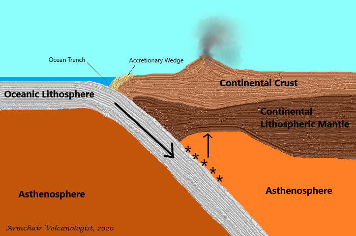
More Explosive Subduction Zones

Magma may also be generated at what is called subduction zones.  Subduction zones occur where plates meet: a denser oceanic lithosphere descends beneath either a less dense continental lithosphere or other oceanic lithosphere. These zones were discovered by two scientists independently researching earthquakes, Hugo Benioff and Kiyoo Wadati. Earthquake foci delineate the descending slab; this zone may be referred to as the Wadati-Benioff zone.   Magma is created from the descending slab by a process called hydration melting: as the slab descends water is squeezed out which mixes with the overlying asthenosphere, lowering its melting temperature.  Hydration melting occurs between 50 km to 200 km, with volcanoes accumulating at around 70 km above the descending slab.  

Magma mixes with the asthenosphere and the crust which increases its silica content. Partial melting of the mantle results in basalts (<52% silica); partial melting of the descending ocean crust provides andesites (52% to 65% silica); and, partial melting of the continental crust gives rhyolites (> 65% silica).  Increasing the silica content of the magma increases its viscosity and the explosivity of eruptions.

These plate boundaries are called destructive boundaries; it is believed that the descending plate is destroyed in the process. 

Fig 3:  Magma generation at a subduction zone by the author, after the many sources available.  Large arrow denotes plate motion; stars, the site of hydration melting; and, the smaller arrow, magma ascent.  The accretionary wedge is rock scraped off as the plates meet. Earthquake foci, not shown, would indicate the path of the descending plate. Not to scale. © All rights reserved, 2020.

Obduction

There is another process where plates meet called obduction; one plate rides over the other.  It is mentioned because obduction revealed the origins of oceanic crust.  Ophiolites, the remnants of old oceanic crust, show that this crust is made up of peridotites from the mantle overlain by old magma chambers, sheet dyke complexes, pillow lavas and sediments.  The magma was sourced from partial melting of the peridotite.  Sheet dyke complexes are complexes of vertical magma intrusions where magma has filled gaps caused by extension from plate separation.  Pillow lavas occur when basalt is erupted underwater.

Magma Evolution

We know that not all magma is basic basalt: there are others, including andesite and rhyolite.  These are formed from basalt by a process called magma evolution.

Magma rises slowly under its natural buoyancy, being around 10% less dense than the surrounding rock.  It tends to accumulate in magma chambers / reservoirs at depths of around 5 km to 20 km below the volcano.  Magma evolves by one or more of the following:

  • Magma mixing: one batch of magma mixes with another in the magma reservoir;
  • Assimilation: the rising magma collects surrounding rock during its ascent;
  • Fractional crystallisation: as magma rises, it cools, which causes the components with higher melting points to crystallise out.

Evolution tends to increase the silicate content of the magma and increase its viscosity; the higher the viscosity, the slower magma moves.

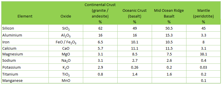
The table below shows a comparison of rock and magma compositions for some its key elements.  The convention for magma composition is based on the oxide equivalents of the elements, presumably on the basis that oxygen does not occur on its own in rock. 

Fig 4:  Comparison of key elements in the composition of different magmas by the author after various sources.  © All rights reserved, 2020.

So how does magma get to the surface?

The short answer is plate tectonics. Distortions in the crust from plate motion either squeeze magma out via existing or new fractures, or provide a wide enough pathway for the magma to ascend.  This is why we see so many volcanoes around plate boundaries.

Eruption Style

Magma contains dissolved gases (e.g. water, carbon dioxide, sulphur, and halogens: chlorine and fluorine).  When the constraining pressure decreases, the gases are released from solution: e.g. carbon dioxide exsolves at depths of several kilometres and sulphur at around 1 km.   This is a process called degassing (think of carbon dioxide released from a fizzy drink when the cap is loosened.) These gases may be held in the magma as bubbles or it may escape via fractures in the crust to the surface.  Measuring gas emissions around volcanoes indicates whether or not new magma is close to the surface.  We have seen with Grímsvötn that Icelandic scientists have reported the presence of sulphur dioxide near the caldera rim, indicating that Grímsvötn may be heading for a new eruption.

Effusive eruptions tend to occur with the less viscous basaltic magmas from which gases can escape gently.  More explosive eruptions are caused when the gases are trapped in more viscous magma and accumulate either as foam or as bubbles; it is their rapid expansion causes an explosive eruption. If a degassing event is large enough, less viscous magmas may also produce explosive eruptions.

When gas bubbles coalesce and expand, large bubbles form which rise with the magma.  If the magma reaches the vent, the bubbles explode with the reduction in constraining pressure, throwing out chunks of lava and ash; some of the chunks can be large boulders.  If gas bubbles get trapped in the magma chamber, when the accumulated pressure is high enough, the gas is forced out as a jet strong enough to cause fire fountains from less viscous basaltic magmas or ash / shards from fractured more viscous magma.  Fire fountains are / were visible in some of Etna’s eruption, in the 2014 eruption at Holuhraun or in the 1783 eruption of Laki. Famous explosive eruptions include Pinatubo, 1991, Krakatau, 1883, and Vesuvius, 79AD,

Impact of ground water or ice

We have seen explosive eruptions from some of Iceland’s basaltic volcanoes.  Another source of volatiles is ground water (aquifers) or glaciers.  When magma gets close enough to these, the heat from the magma flashes the water to steam; the rapid expansion of the water / steam results in an explosive eruption.  If only old rock is involved, the eruption is referred to as phreatic; if new magma is involved, the eruption is referred to as phreatomagmatic.  Phreatic eruptions may be a vehicle to clear the vent / provide a pathway for new magma to reach the surface. Recent phreatic eruptions include White Island, 2019, Mount Ontake, 2014; both caused loss of life because of the unpredictable nature of this eruption type.

Future Topics

There is another important process for magma that we have not touched here: mantle plumes.  We will look at this later.

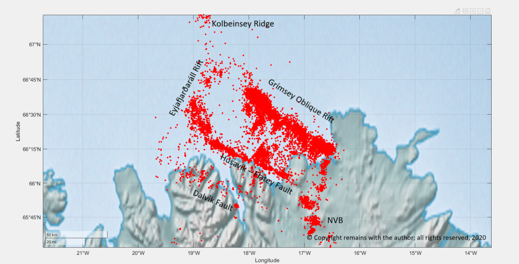
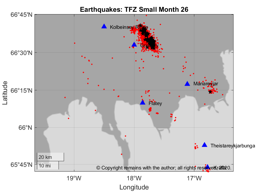
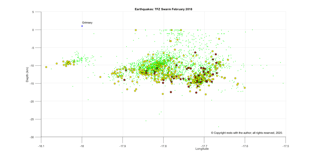
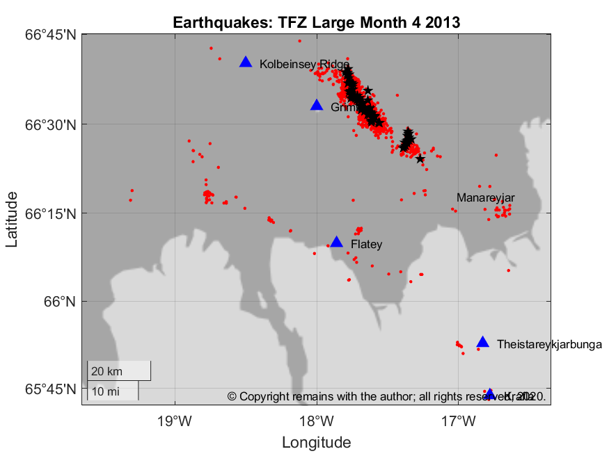
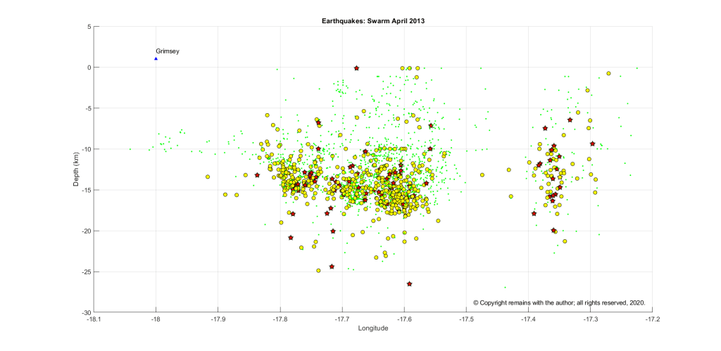
We will also look in more detail the various locations for volcanoes, including the earthquake foci plots that indicate activity (usually tectonic).  Our Icelandic posts show the influence of the Mid Atlantic Ridge; others will look at subduction zones.

We may get diverted / distracted on the way to look at current events of interest.  (Probably, no “may” about it 😉 ).

Thank you for staying with me,

The Armchair Volcanologist

1 July 2020

© Copyright remains with the author; all rights reserved, 2020

Sources and Further Reading

“Volcanoes, Earthquakes and Tsunamis”, David A. Rothery, “Teach Yourself”, 2010

“Volcanoes”, Peter Francis, Clive Oppenheimer, Oxford University Press, 2004

“Volcanoes Global Perspectives”, John P. Lockwood and Richard W. Hazlett, Wiley-Blackwell, 2010

“Wadati-Benioff zone”, Wikipedia: https://en.wikipedia.org/wiki/Wadati%E2%80%93Benioff_zone

“Igneous rock”, Wikipedia: https://en.wikipedia.org/wiki/Igneous_rock

“Magma”, Wikipedia: https://en.wikipedia.org/wiki/Magma

What is a Volcano?

Good Morning!

As this blog is about volcanic and seismic activity, a word or two on what a volcano is might be helpful.

A volcano is defined by the Oxford English Dictionary as mountain or hill with a crater or vent through which rocks, rock fragments, lava, hot vapour and / or gases are or have been erupted through the Earth’s crust.  However, said mountain or hill may be quite small, even just a depression or a rupture in the Earth’s surface.

The island of Vulcano is the source of the term, volcano, itself.  Vulcano Island is located in the Tyrrhenian Sea, north of Sicily, made up of several active volcanoes, including calderas. 

Fig 1: Vulcano Island by Brisk g. in the public domain. Source

So what causes the lava and other matter to be erupted?  What is the Earth’s crust?  These are questions some of the questions we will look at in this blog. 

Heat generated at the Earth’s core drives the geological processes which result in volcanic activity. For starters, we will look at the basics of the earth’s composition, magma and the source of the energy to enable eruptions to occur.

Basics of the Earth’s Composition

This is a very basic description of the Earth’s composition.  The Earth is made up of three main parts: the core, the mantle and the crust. The core is very hot and temperatures decrease towards the Earth’s surface.  Most of the Earth is solid, only the outer core is liquid.  Evidence for this structure has been gleaned from seismic studies, notably how the different wave types generated by an earthquake pass through the Earth, geophysics and the study of rocks.

Fig 2:  Earth’s structure and composition, not to scale, by the author. © Copyright remains with the author; all rights reserved. 2020.

The Core

The radius of the Earth is around 6,378 km, in other words the centre of the Earth’s core can be found 6,738 km down.  The core makes up around one third of the Earth’s mass.  It is made up of an outer core which starts at around 2,900 km down and an inner core which starts at around 5,100 km down.

Material in the core is too dense to make its way to the surface, so there is some uncertainty over its composition.  What we do know is inferred from geophysical studies of the Earth and the chemical analysis of meteorites.  During the Earth’s formation, as rocks and fragments combined to form the planet, denser matter sunk towards the core under gravitational and other forces.  Iron is the chief component of the core, with nickel at the inner core and a lighter element in the outer core (possibly, oxygen, sulphur, carbon, hydrogen or potassium).  The iron in the core and the electrical currents in the molten outer core are the source of the Earth’s magnetic field. 

Seismic studies have shown that the outer core is impermeable to earthquake shear waves (S waves) so acts like a liquid.  Whether or not a layer is liquid or solid is down to the balance between temperature, pressure and chemical composition: while the inner core is around 4,700°C, immense pressure keeps the rock solid.

The Mantle

The mantle is composed of solid rocky materials that are less dense that the outer core; it makes up two thirds of the Earth’s mass.  Density differences mean that the mantle is a distinct layer from the outer core.   The most abundant elements in the mantle are silicon and oxygen, that form silicates.  The mantle is made up of around 45% silica. Magnesium and iron are the third and fourth most abundant elements.  Many other elements are to be found in the mantle, but these tend to be depleted near the boundary with the crust.

The composition of the mantle is inferred from xenoliths (small fragments of rock) contained in some basalt magmas and kimberlites.  Whether or not these are representative of the mantle as a whole or just the fragments that have been erupted is open for debate.

The upper mantle is joined to the crust; the combined layer is referred to as the lithosphere. Below the lithosphere, also in the upper mantle, is the asthenosphere.  The asthenosphere, being weaker than the lithosphere, enables lithospheric slabs to move around (plate tectonics).  The asthenosphere moves at the rate of a few centimetres a year from a process called solid-state convection; hot mantle rises, transfers heat to the lithosphere and the resulting cooled mantle sinks.  The heat in the lithosphere is dissipated through conduction or via rising magma.

The lithosphere is around 120 km thick.  It’s boundary with the asthenosphere is defined by the temperature at which rocks become ductile, around 1,350°C.

The Crust

The crust is a silicate rich brittle layer covering the mantle; it comprises less than 0.5% of the Earth’s mass.  There are two types of crust: oceanic crust, c. 6 km to 11 km thick, mostly basalt, which makes up ocean floors; and, continental crust, c. 25 km to 90 km thick, composed of igneous rocks (granite and andesite), sedimentary rocks and metamorphic rocks, which, as the name suggests, make up the continents and the continental shelves.  Igneous rocks are those resulting from volcanic processes. Sedimentary rocks are those made up of fragments produced by erosion or decay of rocks on the surface.  Metamorphic rocks are sedimentary or igneous rocks altered by changes in temperature and / or pressure. 

Magma

Magma is the molten rock from either the mantle or the crust, itself, that makes its way through the crust to where it may be erupted as lava at a volcano or volcanic fissure.  Magma and lava are the same rock: it is magma until it is erupted; and, lava is the erupted matter.

The composition of the magma and how it is generated determine the eruptive style of the volcano: e.g. effusive or explosive.

Heat

The energy required for matter to be erupted is heat from the Earth’s core.  The Earth’s core is made up of radioactive materials; their radioactive decay generates heat.  Most heat today is generated from four long-lived radioactive isotopes: two uranium isotopes,235U and 238U; one thorium, 232Th; and, one potassium, 40K.  Additional heat came from the decay of the shorter-lived aluminium isotope, 26Al earlier in the planet’s formation.  Asteroid bombardment has also added kinetic energy. 

So we know have the Earth’s crust, magma and heat.  What happens next?  Watch this space. 

The Armchair Volcanologist

24 June 2020

© Copyright remains with the author; all rights reserved. 2020. 

Seismic Activity in the Tjörnes Fracture Zone

Good Afternoon!

It’s back to Iceland to finish off a post I started before being diverted by the earthquake swarm in Nevada.

Having looked at the recent activity at the Reykjanes Peninsula, let’s now look at the Tjörnes Fracture Zone, where the Mid Atlantic Ridge leaves Iceland to head northwards.  Here, current seismic activity is predominantly tectonic.   Our study is based on the same data set used for the introduction to Iceland and the Reykjanes Peninsula (earthquake data downloaded from the Icelandic Meteorological Office(1) from January 2016 to April 12, 2020, updated to May 3, 2020).

Fig 1: Earthquakes in the Tjörnes Fracture Zone Region from January 2016 to April 12, 2020, plotted by the author.  NVB is the Northern Volcanic Belt.  © Copyright remains with the author, all rights reserved, 2020.

Geological Setting

The Tjörnes Fracture Zone (TFZ) is a complex area of transform and extensional faulting connecting the Kolbeinsey Ridge, the Western Volcanic Zone and the Northern Volcanic Zone.  The Kolbeinsey Ridge, itself, is slow spreading at a rate of 10mm per year.  The main faults in the area are: the EyjaFjarðaráll Rift, the Húsavík-Flatey Fault (the TFZ, itself), the Grímsey Oblique Rift and the Dalvik Fault.  Both hydrothermal and seismic activity cluster on the faults. The Húsavík-Flatey Fault has produced earthquakes with magnitudes in the region of 7.0.

Grímsey is an inhabited island on the Arctic Circle. Its main industries are fishing and tourism(2).

Fig 2: Grímsey Cliffs.  Cropped from an image by MosheA, published under CC BY-SA 2.5

Flatey is a small island in Skjálfandi Bay in northern Iceland. It is inhabited in the summer for the tourist season, being home to puffins, terns whimbrels and plovers, amongst others(3).

According to GVP(4) a submarine eruption occurred in 1868 on the Manareyjar Ridge, north of Manareyjar Island, at the south eastern end of the system; the lavas were basalt / picro basalt.  A submarine eruption or dyke intrusion in 1999 caused an earthquake swarm 180km north of Grimsey and 100km north of Kolbeinsey Island on the Southern Kolbeinsey Ridge.  Volcanic activity occurred in 1372 and 1755, but its whereabouts is unclear.

Seismic Activity

In the period from January 2016 to May 3, 2020, there were 26,762 earthquakes reported by the Icelandic Meteorological Office (IMO)(2) for the region. 131 earthquakes had a magnitude of 3.0 or more; 67 occurred in month 26 (February 2018) on the Skajálfandadujúp Rift, 52 miles ENE of Grímsey, the largest of which was 5.21M.

Fig 3: Earthquakes in the Tjörnes Fracture Zone Region, February 2018, plotted by the author.  Black stars denote earthquakes of magnitude 3.0 or more; blue triangles are the approximate locations of volcanoes or volcanic islands. © Copyright remains with the author, all rights reserved, 2020.

A depth plot of the February 2018 swarm shows that most earthquakes over 3.0M occur in the lithosphere.

Fig 4: Depth v Longitude plot of earthquakes April 2018. Green dots denote earthquakes less than 2.0M, yellow circles denote earthquakes over 2.0M; red stars denote earthquakes over 3.0M; blue triangles are the approximate locations of volcanoes or volcanic islands.  © Copyright remains with the author, all rights reserved, 2020.

According to IMO, these swarms have occurred before; the most recent being in May & September 1969, December 1980, September 1988 and April 2013.  The data for most of the earlier swarms is not publicly available on IMO’s website, but we can get data for the April 2013 swarm.  In that swarm, there were 84 earthquakes with a magnitude of 3 or more; the largest of which had a magnitude of 5.37.

Fig 5: Earthquakes in the Tjörnes Fracture Zone Region April 2013, plotted by the author.  Black stars denote earthquakes of magnitude 3.0 or more; blue triangles are the approximate locations of volcanoes or volcanic islands. © Copyright remains with the author, all rights reserved, 2020.

A depth plot of this swarm shows that most earthquakes over 3.0M also occurred in the lithosphere.

Fig 6: Depth v Longitude plot of earthquakes in the April 2013 swarm. Yellow circles denote earthquakes over 2.0M; red stars denote earthquakes over 3.0M; the blue triangle is the approximate location of Grímsey. © Copyright remains with the author, all rights reserved, 2020

How does this compare to the activity on the Reykjanes Peninsula? 

In the Tjörnes Fracture Zone, most seismic activity is occurring in the lithosphere. There is no reported volcanic activity associated with the two swarms we looked. 

Apart from the recent large swarm, the Reykjanes Peninsula shows much less activity in the same period; again, most activity was in the lithosphere. The recent swarm, itself, was atypical (still ongoing at the time of writing, but at a reduced rate) and accompanied by ground uplift – hence the increased monitoring put in place there.

I am not Icelandic so apologies for any typos in Icelandic names.

The Armchair Volcanologist

29 May 2020

© Copyright remains with the author; all rights reserved, 2020

References & Further Reading:

  1. Icelandic Meteorological Office: https://en.vedur.is
  2. Grímsey: https://en.wikipedia.org/wiki/Grímsey
  3. Flatey, Skjálfandi: https://en.wikipedia.org/wiki/Flatey,_Skjálfandi
  4. Smithsonian Institution Natural History Museum Global Volcanism Program (GVP): https://volcano.si.edu
  5. “Present Kinematics of the Tjörnes Fracture Zone North Iceland, from campaign and continuous GPS measurements”, Sabrina Metzger, Sigurjón Jónsson, Gillis Danielsen, Sigrún Hreinsdóttir, François Jouanne,Domenico Giardini, Thierry Villemin, Geophysical Journal International, Volume 192, Issue 2, 1 February 2013, Pages 441–455, https://doi.org/10.1093/gji/ggs032

Credits:

Raw earthquake data downloaded from the Icelandic Met Office: https://en.vedur.is

Plots are the author’s own work.