Good Afternoon!
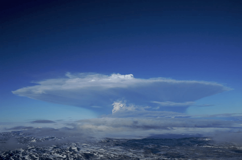
While browsing IMO’s website a few days ago, I saw that signs have been detected that Grímsvötn is getting ready for another eruption, IMO ; a team of scientists noted large sulphur dioxide emissions near the south west caldera rim, indicating that magma is close to the surface. At the time of writing, the alert level for Grímsvötn remains at green.
Grímsvötn is Iceland’s most active volcano, erupting every 10 years and last erupting in 2011 with a VEI 4.
Geological Setting
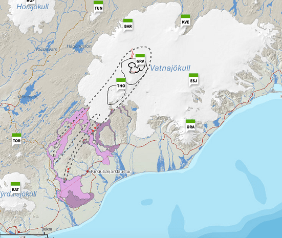
Grímsvötn is one of six active volcanoes under the Vatnajökull ice cap: Bárðarbunga, Kverkfjöll, Grímsvötn, Esufjöll, Þórðarhyrna, Öræfajökull. Apart from Þórðarhyrna (THO in the map below), the other volcanoes are different volcanic systems.
The Vatnajökull volcanoes are part of the Eastern Volcanic Zone in Iceland. Volcanism here is caused by rifting and extension from the separation of the North American and Eurasian Plates. As noted in an earlier post, the Eastern Volcanic Zone accommodates 40 to 100% of the separation.
Our description of the Grímsvötn volcanic system is largely based on Magnús T. Guðmundsson and Guðrún Larsen’s description in Icelandic Volcanoes (ref. Sources below for the full accreditation).
The Grímsvötn volcanic system
The Grímsvötn volcanic system, itself, is made up of two central volcanos and fissure swarms. It is partly covered by ice.
The Central Volcanoes
The Grímsvötn central volcano is a 1722m high, 15-16km diameter caldera complex covered by the Vatnajökull ice-cap, with ice depths of 100m to 700m; she has an 8km by 10km ice-filled caldera. Grímsfall (GFUM) is the highest point on the caldera rim. There is a subglacial lake in the caldera under a 200 – 300m ice shelf with an associated geothermal area. The lake has been the source of many jökulhlaups.
The Þórðarhyrna central volcano, also subglacial, is a 1650 high with a 15 km diameter, connected to Grímsvötn by a subglacial ridge. The volcano, itself, has a small intrusive complex but does not appear to have a large magma reservoir. There is a geothermal area near Pálsfjall.
Ice cover has restricted study of the volcanoes. However, Grímsvötn has been around for long enough to develop a caldera – possibly more than 100,000 years.
Grímsvötn’s lava types are tholeiitic basalt with basaltic andesite and dacite / rhyolitic outcrops in the Þórðarhyrna central volcano. The presence of a shallow magma reservoir is inferred from the geothermal field in the caldera. The 2011 eruption of Grímsvötn produced 0.8km3 basaltic tephra.
Þórðarhyrna is less active than her neighbour; the last eruption occurred in 1903 with a VEI 4. It is possible that she had a second eruption in 1753, resulting in jökulhlaups. Again, ice cover has limited geological study. There is little seismic activity near Þórðarhyrna.
The Fissure Swarms
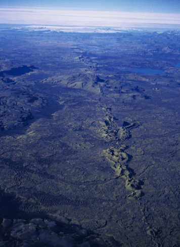
The fissure swarm is about 100 km long and 18 km wide. Rifting is believed to occur along the entire swarm. The northern end of the fissure swarm is covered by the Vatnajökull ice-cap; the southern 80km is ice-free. Subglacial ridges characterise the northern end of the fissure, but not the ice-free southern end where crater rows delineate the fissure, including the Laki.
Three known subglacial eruptions have occurred since 1867 at Gjálp 10km to 15km north of Grímsvötn, itself. The eruptive products include subglacial ridges and some airborne tephra. The 1996 eruption produced basaltic andesite.
Four effusive eruptions have been identified in the ice-free section of the fissure swarm southwest of Grímsvötn in the last 8,000 years; lava volumes have been between 1 km3 to 14 km3 with up to 0.7km3 of tephra. The largest fissure eruption was the Laki eruption in 1783 to 1784. No eruptions have been identified for the ice-covered section of the fissure swarm.
The Laki Fissure Eruption 1783 -1784
This eruption was well documented at the time; the Reverend Jón Steingrímsson’s 1788 account in “A complete description of the Síða Fires” gives a detailed eye-witness account.
The 1783 eruption occurred on 27km long fissure and lasted from 8 June 1783 to 7 February 1784. The early phase consisted of a series of ten or more explosive tephra events, each followed by effusive lava flows. Grímsvötn, itself, erupted in July 1783 to May 1785 causing ash fall and jökulhlaups.
The Laki eruption was pre-empted by earthquakes of increasing intensity from mid-May to 8 June 1783 when a large ash cloud and ash fall appeared, followed by lava columns over 1km high from new fissure to the north. Volcanic gases filtered out sunlight, making the Sun appear red. Accompanying rainfall was acidic, irritating people’s eyes and skin. Lava flows filled river gorges, overflowing to cover surrounding farmland. During the eruption, Mount Laki was destroyed; I am not sure how big she was and how much her destruction contributed to the vast tephra output.
The eruption is rated a VEI4, having produced 0.7km3 of tephra which covered more than 8,000 km2, and 14 km3 of lava. Volcanic gases, including fluorine, killed more than half of the livestock and the “Haze Famine” killed 20% of the Icelandic population. Further afield, 100 million tonnes of sulphur dioxide, having reached the jet stream, spread acidic sulphate aerosols round the Northern Hemisphere, damaged vegetation and crops in Europe and Alaska, caused severe winters and annual cooling of around 1.3°C that lasted for two to three years.
According to GVP, the Grímsvötn volcanic system has had 86 Holocene eruptions ranging from VEI 0 to VEI 6. The VEI 6 occurred around 10200 BP and is the thought to be the source of the Saksunarvatn Tephra, a basaltic tephra which covered an area of 2 million km2 around the North Atlantic. The Saksunarvatn Tephra, like the Vedde Ash from Hekla, is a geological time marker, although radiocarbon dating of the Saksunarvatn Tephra shows that it may have come from seven eruptive events over a 500 year period from 10400 BP to 9900 BP
Grímsvötn’s most recent eruptions from 1996 to 2011 range from VEI 3 to VEI 4. They were preceded by a small increase in seismicity and small earthquake swarms, except for the 1996 Gjálp eruption. The 1996 eruption was preceded by a 5.4 earthquake on Barðabunga’s northern caldera rim, swarms over a two day period at Barðarbunga’s north and northwest caldera rims and at Grimsvotn’s southern caldera rim, followed by a swarm from the north Bardarbunga caldera rim that migrated to Gjálp.
Recent Seismicity
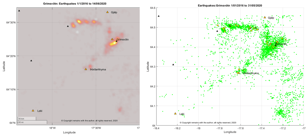
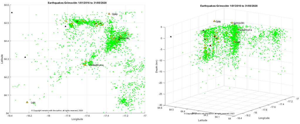
So, what does our earthquake data set tell us about the likelihood of an eruption at Grímsvötn? The answer is a disappointing “not a lot”. We can see that Grímsvötn has a fairly steady stream of earthquakes but no obvious swarms. However, given the proximity of Grímsvötn to other volcanoes, we may have attributed some of Grímsvötn’s activity to another volcano in error. Plots are shown below, including one for Vatnajökull which shows the problem.
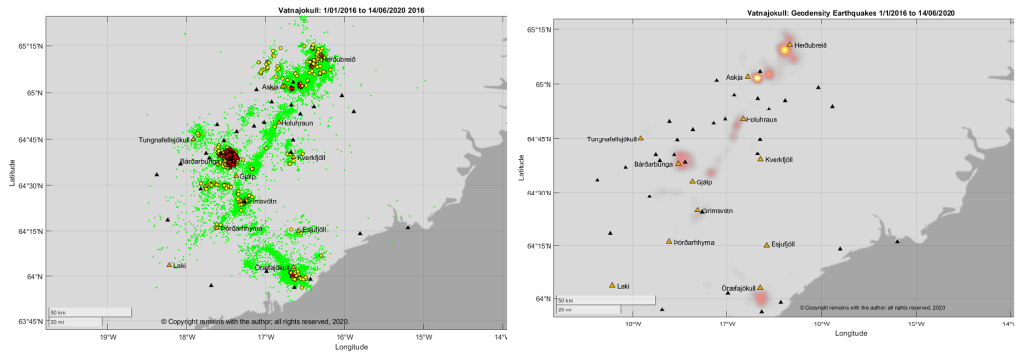
The earthquake plots of the Vatnajökull region show the SW-NE trending fissure swarms and also a SE-NW trending line of earthquakes. The head of the mantle plume is considered to be under the Vatnajökull ice-cap; perhaps we are seeing its influence on the plate junction? We can also see the proximity of Grímsvötn to Bárðarbunga.
The Grímsvötn system, with 3,326 earthquakes, is not the most seismically active volcano; activity is overshadowed by seismic activity at Bárðarbunga (5,464 earthquakes), Askja and Herðubreið (a combined 15,645 earthquakes) and Öræfajökull (4,770 earthquakes). The 2014 eruption of Holuhraun was both preceded and accompanied by intense seismic activity at Bárðarbunga, notably near the edges of the caldera, and deflation at Bárðarbunga. Since the eruption, Bárðarbunga has started to re-inflate. Our data set starts a year or more after the end of that eruption.
Looking more closely at Grímsvötn we see that earthquake activity is focused on the south east of the caldera and at an E-W trending fissure to the north east of the volcano. The E-W fissure is parallel to similar lines of activity further north at Bárðarbunga’s caldera. We also picked up some activity at Þórðarhyrna.
The earthquakes are telling only part of the story. Grímsvötn has had a steady stream of earthquake activity during the period, but without the SO2 measurements from scientists, we would not be certain that magma, itself, was near the surface.
For updates on Grímsvötn, please visit IMO’s website (details below).
The Armchair Volcanologist
22 June 2020
Sources and Further Reading
“Grímsvötn”, Magnús T. Guðmundsson and Guðrún Larsen (Institute of Earth Sciences – Nordvulk, University of Iceland) In: Oladottir, B., Larsen, G. & Guðmundsson, M.T., Catalogue of Icelandic Volcanoes. IMO, UI and CPD-NCIP. Retrieved from Icelandic Volcanoes: http://icelandicvolcanos.is/?volcano=GRV
“Þórðarhyrna”, Magnús T. Guðmundsson and Guðrún Larsen (Institute of Earth Sciences – Nordvulk, University of Iceland) In: Oladottir, B., Larsen, G. & Guðmundsson, M.T., Catalogue of Icelandic Volcanoes. IMO, UI and CPD-NCIP. Retrieved from Icelandic Volcanoes: http://icelandicvolcanos.is/?volcano=THO
Fig 2: Map: After Guðmundsson and Miller (1997), Guðmundsson et al (2013a), Jóhannesson and Sæmundsson (1998a), Jóhannesson et al (1990). Base data, Iceland Geo Survey, IMO, NLSI | Base map: IMO. In: Oladottir, B., Larsen, G. & Guðmundsson, M.T., Catalogue of Icelandic Volcanoes. IMO, UI and CPD-NCIP. Retrieved from Icelandic Volcanoes: http://icelandicvolcanos.is/?volcano=GRV
Smithsonian Institution Natural History Museum Global Volcanism Program (GVP): https://volcano.si.edu
Earthquake data: Icelandic Meteorology Office: IMO https://en.vedur.is/earthquakes-and-volcanism/earthquakes
Plots are the author’s own work.
© Copyright remains with the author; all rights reserved, 2020
