On 9th October 2026 at 17:56:06 UTC a shallow 7.7 struck 12 km WSW of Pitaloza Arriba, Panama, with a depth of 12.6km. c. 100 aftershocks have been reported, including a 6.6 on the same day.
A state of emergency was declared yesterday, 10th October 2026. At the time of writing no fatalities have been reported but significant damage to homes, schools, health-care facilities, roads and hotels has occurred in all of Panama. However, some communities remained cut off due to landslides and road damage. Most of the damage was concentrated in the central provinces of Veraguas, Herrera, Cocle and Los Santos. The Panama Canal was operating normally but being inspected for damage.
Tectonics
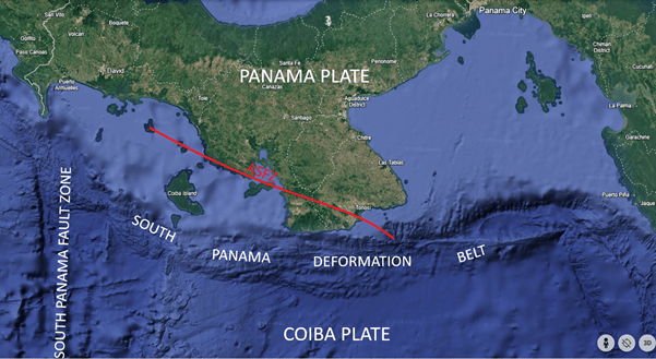
The earthquake occurred near the Azuero-Soná Fault Zone (ASFZ), a 300 km geological fault zone which runs from the South Panama Deformation Belt (SPDB) across the Azuero and Soná Peninsulas to the Pacific Ocean. The South Panama Deformation Belt marks the boundary between the Panama Plate and the Coiba Plate. Both the ASFZ and SPDB are transform fault zones. The 9th October earthquake’s focal mechanism indicates left-lateral strike-slip faulting, consistent with the style of deformation commonly observed along this complex plate boundary.
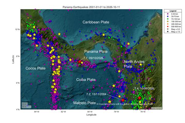
Panama is located on the Panama Plate, surrounded by several tectonic plates, the Cocos, Carribean, North Andes and Coiba Plates. Along the southern boundary, the Cocos plate subducts beneath the Panama Plate and the Coiba Plate obliquely converges with the Panama Plate, while along its northern boundary, the Caribbean Plate subducts beneath it.
USGS report that earthquakes are frequent in this region, although most historical seismicity has been concentrated west of today’s event along the Panama Fracture Zone, a north-south-trending plate boundary that separates the Cocos and Coiba plates. Notable historical earthquakes in the broader area include a magnitude 7.5 event in July 1934 and a magnitude 7.2 event in July 1962.
We have plotted earthquakes from 1st January 2001 to 11th October 2026 between 4.0N, 75.0W and 11.5N and 84.75W. The geoscatter plot is shown as Fig 1 above. The scatter plot is shown in the video below. The plots clearly show the subduction zones in the area: the Cocos plate subducting under the Panama Plate in the north west, the Coiba and Malpelo Plates subducting under the North Andes Plate in the east and the Caribbean Plate subducting under the Panama Plate in the north east of the plots.
Our thoughts are with all those impacted by this event.
Armchair Volcanologist
© Copyright remains with the author; all rights reserved, 2026
Sources:
BBC News: Powerful magnitude 7.7 earthquake hits Panama, damaging buildings – BBC News
The Guardian: ‘It was a terrible thing’: Panama declares state of emergency as quake aftershocks rattle communities | Panama | The Guardian Raw earthquake data: Earthquakes | U.S. Geological Survey

