At 4:58 am local time on 15th August 2026 (14th August 21:58 UTC) a 7.7 magnitude earthquake struck 68 km north of Ende on Flores, with a depth of 10km. At the time of writing, 47 fatalities have been reported with damage to infrastructure and more than 150 houses. USGS are predicting some (downgraded from significant) casualties and damage. Our thoughts go out to all those impacted.
Flores Island, Indonesia is located at eastern end of the Sunda Arc, which runs from 105°E to 122°E; the Banda Arc runs from 122°E to 128°E. The Sunda Arc, home to some of the World’s most explosive volcanoes, including Krakatau, Mount Tambora and Mount Samalas, formed from simple oceanic subduction of the Indo-Australian Plate beneath the Sunda and Burma plates at a velocity of 63–70 mm/year.
The Banda Arc is a double island arc in eastern Indonesia that is around 2,300 km long. It is the result of the collision of a continent and an intra-oceanic island arc. The Inner Banda Arc consists of a string of volcanic islands from Komodo to Kekeh-besar of the Barat Daya Islands, including Flores, Solor, Alor, Wetar, and Damar. The Outer Banda Arc consists of Australian continental margin cover units that were scrapped off the Australian plate and added to the southern edge of the ovrriding plate.
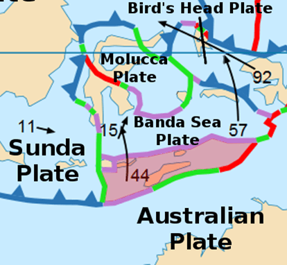
Flores lies to the east of the Sunda Plate near the convergent boundary between the Timor Plate and Banda Sea Plate, with the transform boundary between these plates and the Sunda Plate to its west. The Flores Zone, itself, is thought to be the transition between subduction and continental collision, with downward dip compression of the subducted slab and late Quaternary uplift of the forearc.
We plotted the earthquakes from 1st January 2006 to 15th August 2026 between 5°S,118°E to 12°S,126°E using publicly available data from USGS. The 7.7 earthquake occurred near the boundaries between the Sunda Plate, Banda Sea Plate and Timor Plate, the result of reverse faulting at shallow depth, possibly in the overriding crust of the Banda Sea Plate. Our earthquake plots demonstrate the dominance of the subduction of the Indo-Australian Plate.

We hope you find the above plots useful.
Armchair Volcanologist
© copyright remains with the author; all rights reserved, 2026
Sources:
Raw earthquake data: USGS: Earthquakes | U.S. Geological Survey
USGS: M 7.7 – 68 km NNW of Ende, Indonesia
Timor Plate: Timor plate – Wikipedia
Sunda Arc: Sunda Arc – Wikipedia
Banda Arc: Banda Arc – Wikipedia

