On 24th June 2026, two large shallow doublet earthquakes with magnitudes of 7.2 and 7.5 and depths of 20 km and 11.1 km, resp., struck northern Venezuela within 39 seconds of each other. The death toll at the time of writing is 3,811 with 16,740 injured, tens of thousands reported missing and 17,854 who have lost their homes. Roughly, 60,000 buildings were destroyed. USGS modelling for each shock predicts higher numbers of fatalities and significant economic loss of between 4 to 20% of Venezuela’s GDP. Our thoughts are with all those who have lost their lives, livelihoods, friends or homes, and also with those involved with the relief effort.
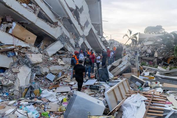
The first shock occurred 21 km ENE of San Felipe at 23:04:34 and the second occurred 20 km ESE of Yumare at 23:05:11. Because the earthquakes occurred such a short time period apart the deformation from each is hard to distinguish. Some organisations report them as a single event, e.g. INGV reports the earthquakes as a single event of magnitude 7.6 with two bursts of high energy release, having analysed the deformation from satellite data (Sentinel – 1). In the first burst, slip occurred along a 210 km by 30 km section of the fault ,moving with a velocity of 3 – 3.5km per second to north east of Caracus; it started with 2.5 m of slip t a depth of 20km near Morón. The second burst had a maximum slip of 3.6m north of Catia La Mar at a depth of 11.1km.
The earthquakes occurred on or near the San Sebastián fault system which is part of the larger Boconó– San Sebastián – El Pilar fault system. The Bonocó Fault is 500 km long strike slip fault located in the Eastern Ranges of northeastern Colombia and the Mérida Andes of northwestern Venezuela; it has been active since the Early Holocene. It is part of the boundary between the North Andes Plate and the South American Plate. The San Sebastián Fault Zone is 500 km long, located mostly offshore in the Caribbean Sea north of Venezuela. It is right-lateral strike-slip, forming part of the boundary between the Caribbean and South American tectonic plates. The El Pilar Fault System is 700 km long, located in state of Sucre in northern Venezuela. The fault system is of right-lateral strike-slip type with an east–west orientation and also forms part of the transform plate boundary between the Caribbean and South American plates.
The South American Plate is moving west at a rate of 32 mm per year, the North Andes Plate north west at a rate of 23 mm per year and the Caribbean Plate north west at a rate of 11 mm per year. Because movement the Caribbean Plate is slower than the North Andes Plate, it subducts under the northwest margin of North Andes Plate; the North East margin is extensional. The boundary between the Caribbean Plate and South American Plate comprises transform faults.
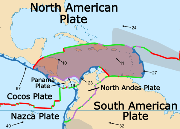
The San Sebastian fault system has produced large earthquakes in the past. In 1812 the Caracas earthquake with magnitude 7.7 caused 15,000 to 20,000 fatalities. It is thought to have involved two sub-events, the first on the Boconó Fault and the second on the western part of the San Sebastián Fault. In 1900 San Narciso earthquake with magnitude 7.7 is thought to have been caused by rupture along the San Sebastián Fault to the east of Caracas. Before the recent earthquakes geophysicists had calculated that the accumulated slip deficit on the Bonocó fault could produce a 7.0 – 7.6 magnitude earthquake and likewise the San Sebastián fault might produce a 7.1 magnitude earthquake.
We have plotted the earthquakes between in the region between 15.0°N, 73.0 ° W and 7 ° N, 62.5 ° W from 1st January 2006 to 10th July 2026. In addition to the area of interest, this picks up part of the subduction of the Caribbean Plate under the North Andes Plate to the west of the plots and also the subduction of the South American Plate under the Caribbean Plate to the east of the plot. The latter includes a 7.3 magnitude earthquake at depth. Seismic activity in the area where the recent 7.2 and 7.5 earthquakes occurred tends to comparatively shallow, consistent with a transform plate margin.
Our first plot is a geoscatter plot. In this plot we can see that the doublet earthquakes occur near the junction of the three plates: Caribbean Plate, North Andes Plate and South American Plate.
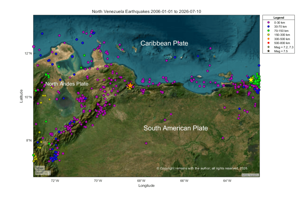
We hope you find the above plots interesting. In our earlier post: Mt. Pelée, La Soufrière St. Vincent And A Quick Tour Of The Plates Surrounding The Caribbean Plate, we also looked at seismicity in a wider area.
Armchair Volcanologist
Sources:
USGS: Earthquakes | U.S. Geological Survey
Wikipedia: 2026 Venezuela earthquakes – Wikipedia
© Copyright remains with the author; all rights reserved, 2026.

