On 24th June 2026, two large shallow doublet earthquakes with magnitudes of 7.2 and 7.5 and depths of 20 km and 11.1 km, resp., struck northern Venezuela within 39 seconds of each other. The death toll at the time of writing is 3,811 with 16,740 injured, tens of thousands reported missing and 17,854 who have lost their homes. Roughly, 60,000 buildings were destroyed. USGS modelling for each shock predicts higher numbers of fatalities and significant economic loss of between 4 to 20% of Venezuela’s GDP. Our thoughts are with all those who have lost their lives, livelihoods, friends or homes, and also with those involved with the relief effort.
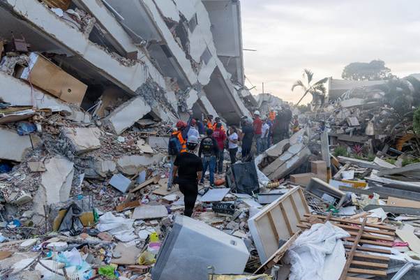
Fig 1: Photo of rescuers inLa Guaira, Venezuela, June 28, 2026. Attribution:U.S. Marines 24MEU by Cpl. Daniel Garcia, Public domain, via Wikimedia Commons
The first shock occurred 21 km ENE of San Felipe at 23:04:34 and the second occurred 20 km ESE of Yumare at 23:05:11. Because the earthquakes occurred such a short time period apart the deformation from each is hard to distinguish. Some organisations report them as a single event, e.g. INGV reports the earthquakes as a single event of magnitude 7.6 with two bursts of high energy release, having analysed the deformation from satellite data (Sentinel – 1). In the first burst, slip occurred along a 210 km by 30 km section of the fault ,moving with a velocity of 3 – 3.5km per second to north east of Caracus; it started with 2.5 m of slip t a depth of 20km near Morón. The second burst had a maximum slip of 3.6m north of Catia La Mar at a depth of 11.1km.
The earthquakes occurred on or near the San Sebastián fault system which is part of the larger Boconó– San Sebastián – El Pilar fault system. The Bonocó Fault is 500 km long strike slip fault located in the Eastern Ranges of northeastern Colombia and the Mérida Andes of northwestern Venezuela; it has been active since the Early Holocene. It is part of the boundary between the North Andes Plate and the South American Plate. The San Sebastián Fault Zone is 500 km long, located mostly offshore in the Caribbean Sea north of Venezuela. It is right-lateral strike-slip, forming part of the boundary between the Caribbean and South American tectonic plates. The El Pilar Fault System is 700 km long, located in state of Sucre in northern Venezuela. The fault system is of right-lateral strike-slip type with an east–west orientation and also forms part of the transform plate boundary between the Caribbean and South American plates.
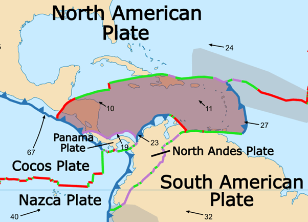
The South American Plate is moving west at a rate of 32 mm per year, the North Andes Plate north west at a rate of 23 mm per year and the Caribbean Plate north west at a rate of 11 mm per year. Because movement the Caribbean Plate is slower than the North Andes Plate, it subducts under the northwest margin of North Andes Plate; the North East margin is extensional. The boundary between the Caribbean Plate and South American Plate comprises transform faults.
Fig 2: Caribbean (brown shaded area) and surrounding plates by Alataristarion, published under CC BY-SA 4.0, via Wikimedia Commons.
The San Sebastian fault system has produced large earthquakes in the past. In 1812 the Caracas earthquake with magnitude 7.7 caused 15,000 to 20,000 fatalities. It is thought to have involved two sub-events, the first on the Boconó Fault and the second on the western part of the San Sebastián Fault. In 1900 San Narciso earthquake with magnitude 7.7 is thought to have been caused by rupture along the San Sebastián Fault to the east of Caracas. Before the recent earthquakes geophysicists had calculated that the accumulated slip deficit on the Bonocó fault could produce a 7.0 – 7.6 magnitude earthquake and likewise the San Sebastián fault might produce a 7.1 magnitude earthquake.
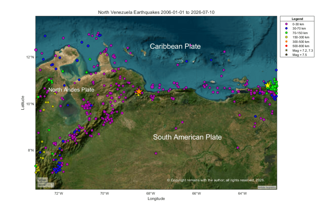
We have plotted the earthquakes between in the region between 15.0°N, 73.0 ° W and 7 ° N, 62.5 ° W from 1st January 2006 to 10th July 2026. In addition to the area of interest, this picks up part of the subduction of the Caribbean Plate under the North Andes Plate to the west of the plots and also the subduction of the South American Plate under the Caribbean Plate to the east of the plot. The latter includes a 7.3 magnitude earthquake at depth. Seismic activity in the area where the recent 7.2 and 7.5 earthquakes occurred tends to comparatively shallow, consistent with a transform plate margin.
Our first plot is a geoscatter plot. In this plot we can see that the doublet earthquakes occur near the junction of the three plates: Caribbean Plate, North Andes Plate and South American Plate.
On 4 December 2020 the alert level for Mt. Pelée was raised to yellow due to increasing seismicity above background levels; and, on 29 December 2020 the alert level for La Soufrière St. Vincent was raised to orange following an increase in seismic activity, changes seen in the lake and fumaroles and a new growing lava dome emerging in the summit crater.
This led us to look into what drives volcanism in the area, notably the interaction of the Caribbean Plate with its surrounding plates.
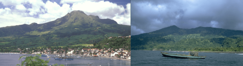
Fig 1: Mt. Pelée on the left with St. Pierre, photo by Lee Siebert, 2002 (Smithsonian Institution); Soufrière St. Vincent on the right, photo by William Melson, 1972 (Smithsonian Institution).
Mt. Pelée is famous for destroying the town of Saint- Pierre and its inhabitants plus visitors – a total of 29,000 people – in a matter of minutes on the morning of 8 May 1902 in a pyroclastic flow during a VEI 4 eruption. La Soufrière St. Vincent also erupted around the same time. Both volcanoes are located in the Lesser Antilles on the Caribbean Plate.
Mt. Pelée
Mt. Pelée is located on Martinique. She is a 1,400m high stratovolcano located in the caldera of an earlier volcano; edifice failures have breached the south west section of the caldera. Her lava types are andesite, basaltic andesite, dacite and basalt, picro basalt.
54 Holocene eruptions are recorded by GVP. Her historic eruptions include 1792 (VEI 1), 1851 (VEI 2), 1902 (VEI 4) and 1929 (VEI 3). Two lava domes were emplaced in the summit crater, l’Etang Sec, during the 1902 and 1929 eruptions.
1902 Eruption
Prior to the 1902 eruption, Mt Pelée’s known eruptions had been mild. Activity at the volcano started to ramp up gradually with fumaroles in the summit crater in 1889 to March 1902. From 23 April 1902 phreatic activity cleared out old rock, starting with minor explosive activity. By 4 May 1902 ash was raining down on Saint- Pierre. On 5 May, 23 people were killed when near boiling water from the crater heated by rising magma overran a distillery in a lahar in the Rivière Blanche valley.
On 6 May 1902, new lava emerged creating a lava dome. During 7 May 1902, small parts of the dome collapsed. At 07:50 on 8 May 1902, explosions were heard and a large black cloud seen to emerge and flow down the volcano, engulfing Saint-Pierre and some of the ships in the harbour. Most of the casualties were killed by hot gases and dust from the blast. Several pyroclastic flows followed: on 20 May 1902 a second pyroclastic current swept over Saint-Pierre destroying several of the remaining buildings; the Rivière Blanche valley saw several PDCs over the ensuing months; and, Morne Rouge was destroyed and 2,000 people killed by a pyroclastic current on 30 August 1902. During this activity a 300m lava spine emerged. After this eruptive activity continued until 1903. The lava spine has since been eroded.
Saint-Pierre had not been evacuated prior to 8 May 1902 for a couple of reasons: it was not known at the time that the volcano produced pyroclastic flows so the danger was not understood; and, an election was due on 11 May 1902, which politicians were keen should go ahead. No evacuation order was given.
When activity ramped up again prior to the 1929 eruption, people were evacuated in time.
La Soufrière St. Vincent
La Soufière St. Vincent can be found on St Vincent Island. She is a 1,234m high stratovolcano with crater lake and lava domes. The 1.6km wide summit crater is located on the south west edge of a 2.2km wide Somma crater; slope failure caused a breach in the Somma crater. Her lava types are andesite, basaltic andesite and basalt, picro basalt.
22 Holocene eruptions are recorded by GVP. Her historic eruptions include 1718 (VEI 3), 1812 (VEI 4), 1902 (VEI 4), 1971 (VEI 0) and 1979 (VEI 3). The 1902 eruption occurred on 6 May 1902, killing 1,680 people. The 1812 eruption produced a new crater, cutting through the summit crater. 1971 eruption extruded a lava dome in the summit crater, which erupted explosively in 1979 to be replaced by another dome.
Tectonic Setting
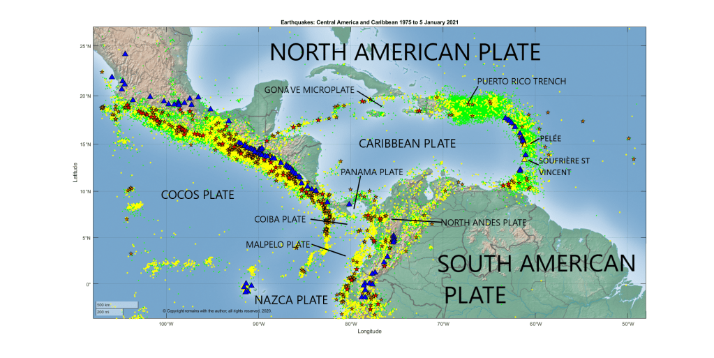
As noted above, both Mt. Pelée and La Soufrière St. Vincent are located on the Caribbean Plate in the Lesser Antilles. The Caribbean Plate is thick oceanic crust located between the North American and South American Plates. The northern boundary of the Caribbean Plate is a transform boundary with the North American plate, running from Central America to the Virgin Islands. The Gonâve microplate and Puerto Rico Trench form part of the northern boundary. At the eastern boundary, the South American Plate subducts under the Caribbean Plate in the Lesser Antilles. At the western boundary, the Cocos Plate subducts under the Caribbean Plate, forming the Central American Volcanic Arc. The southern boundary with the South American plate is a complex, comprising a convergent margin with the Panama Plate, a subduction zone with the North Andes Plate and a transform boundary with the South American Plate. The main plates velocities relative to the African Plate are noted below.
Plate
Direction
Velocity
North American Plate
West
25 mm per year
Cocos Plate
North east
67 mm per year
Caribbean Plate
North west
10 mm per year
Panama Plate
North west
19 mm per year
Coiba and Malpelo Plates
East
North Andes Plate
North west
23 mm per year
Nazca Plate
North east
40 -53 mm per year
South American Plate
West
27 – 34 mm per year
The origins of the Caribbean Plate are debated. There are two main theories which attempt to explain why the less dense but thicker crust of the plate overrides the Cocos and South American Plates. It may have evolved millions of years ago from the Caribbean large igneous province, formed at the Galapagos hotspot, drifting to its current location as the plates moved to accommodate the widening of the Atlantic Ocean. Alternatively, it may have formed from an old hotspot in the Atlantic. These theories are based on the relative motions of the plates. The first theory works on the basis that the Caribbean Plate is moving eastward compared to the North and South American Plates, whereas the latter uses the actual westward motion of the Caribbean Plate.
Recent Seismicity
Yes, we’ve downloaded earthquakes for the region from USGS’s earthquake search, taking a larger area than the Caribbean Plate in order to pick up the subduction zones. In this case, it was not really necessary as most subduction is beneath the Caribbean Plate, but it was fun to find several microplates in the process: the Gonâve, Panama, Coiba and Malpelo Plates. The Malpelo Plate was first identified as late as 2017 by Tuo Zhang, Richard G Gordon et al of Rice University.
The coordinates selected were: 3.760°S, 107.051°W to 26.838°N, 48.867°W for earthquakes with magnitudes of 2.5 or more between 1 January 1975 and 5 January 2021. This picked up 80,751 earthquakes.
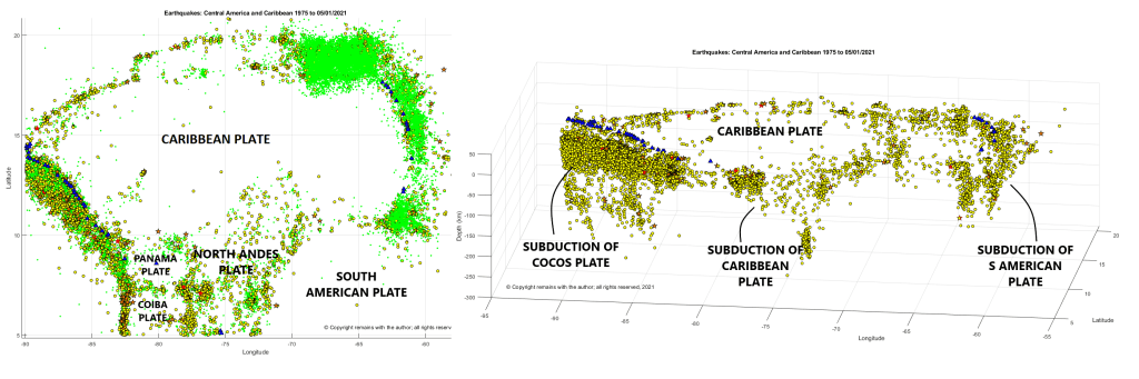
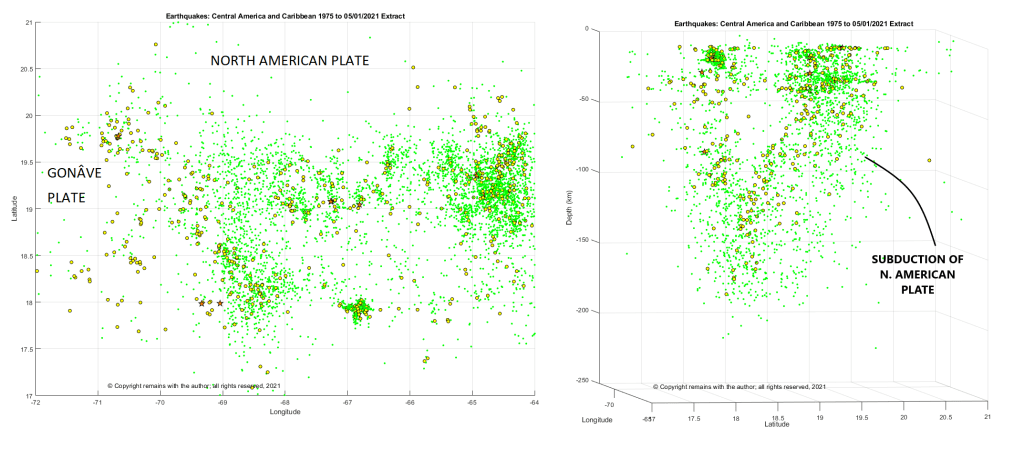
From Figs 2, 3 and 4 below, we can see the plate boundaries and the subduction zones on the western and eastern margins of the Caribbean plate are well marked by earthquakes and volcanoes; the subduction of the Caribbean Plate under the North Andes Plate is also visible (lower centre of the depth plot); and, the Puerto Rico Trench is also tectonically very active. The Puerto Rico Trench has produced some large earthquakes and tsunamis.
Fig 4 shows subduction of the North American Plate on the right of the depth plot. But there is also a line of earthquakes on the left of the plot which appears to indicate another subduction zone. Neither subduction zone here, despite being seismically active, has active volcanoes associated with it. It’s possible that there is another microplate here, but this is conjecture on our part until we can find an explanation or confirmation.
If you are interested or concerned by the alert statuses of Mt Pelée and La Soufrière St Vincent, you can find more information at L’Observatoire Volcanologique et Seismologique de Martinique, the National Emergency Management Organisation (NEMO) or GVP.
Hope you enjoyed our little tour. We will be looking in more detail at points of interest in the future.
Zhang, Tuo; Richard G. Gordon; Jay K. Mishra, and Chengzu Wang. 2017. The Malpelo Plate Hypothesis and implications for nonclosure of the Cocos-Nazca-Pacific plate motion circuit, 1. AGU Fall Meeting, New Orleans. Accessed 2018-06-06.
“Volcanoes”, Peter Francis and Clive Oppenheimer, Oxford University Press, Second Edition, 2004.