Tag Archives: Svartsengi Volcanic System

Svartsengi – Not Yet, 20th August 2026

At the time of writing, Svartsengi has not erupted since the last eruption which ended on 5th August 2025.  The Icelandic Meteorological Office issued an update on 18th August 2026 stating that (we quote):

  • Land uplift at Svartsengi continues at a slow but steady rate
  • Seismic activity remains low
  • The hazard assessment remains unchanged

Land uplift and magma accumulation are continuing at Svartsengi. The development remains slow but steady. The latest model calculations indicate that approximately 29.1 million cubic metres of magma have accumulated beneath Svartsengi since the beginning of the last eruption in July 2025. The uncertainty range is between 28.3 and 29.9 million cubic metres.

As magma continues to accumulate and pressure increases within the system, the most likely scenario is that a magma intrusion will propagate from Svartsengi into the Sundhnúkur crater row. This could lead to a volcanic eruption. As before, the warning time could be short. Previous eruptions have had warning times ranging from approximately 20 minutes to just over four hours.”

We have updated our earthquake plots from 6th August 2025 to earlier today, 20th August 2026, looking at the area 63.746°N,22.7°W to 63.996°N, 22.1°W. From our plots, we can see that most earthquakes are occurring in or just above the top of the crust.  There is more shallower activity under Svartsengi, itself.  As there is an aseismic zone up to c.2km depth, we cannot easily predict based on seismic activity alone  if, or when, magma will reach the surface.
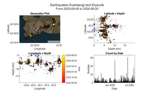
Fig 1: Geoscatter and scatter plots by the author of earthquakes from 6th August 2025 20th August 2026, looking at the area63.746°N,22.7°W to 63.996°N, 22.1°W.  Colour denotes time, size denotes magnitude and the white / blue triangle shows the location of the Svartsengi volcanic system. © Copyright remains with the author; all rights reserved, 2026.

Armchair Volcanologist

© Copyright remains with the author; all rights reserved, 2026.

Source for the raw earthquake data and the update: Icelandic Meteorological Office

Earthquake Swarm on the western Reykjanes Peninsula 17th April 2022 to date: updated earthquake plots.

An earthquake swarm started on the Reykjanes Peninsula on 17th April 2022 and is continuing at the time of writing. This swarm is part of a larger volcano-tectonic episode that started at the end of 2019 on the Reykjanes Peninsula, including the eruption at Geldingadalir.  

Local volcanologists are reporting now that recent ground deformation of 3.5cm suggests a magma intrusion in the vicinity of Svartsengi, north of the town of Grindavík. Magma is believed to be pooling at a depth of c. 4km between Mount Þorbjörn and the Eldvörp crater row. This is an area which can produce large earthquakes of 6.5M. People are advised to avoid areas where landslip is likely.

Fig 1: Image cropped from a photo by Roman Zacharij of Grindavik, Iceland (Source: Wikimedia Commons, Public Domain).

We have updated our earthquake plots to show the swarm to date.  Our plots exclude an earthquake occurring earlier today with a depth of 40.7km to keep the detail in the plots showing depth; the earthquake omitted is 19/05/2022, 00:11:14,  63.77°N , 22.75°W, 40.7km, 1 magnitude. Since we downloaded the data at 09:55 am today, there has been a 3.0 magnitude, 4.9 km NNE of Grindavík.   

Our plots show possible doming in the vicinity of Mount Þorbjörn and  the Svartsengi Volcanic System.

Fig 2:  Video by the author of earthquake activity on the western  Reykjanes Peninsula between 17th April 2022 to 19th May 2022 09:55 am.  The keys are in the video.  © Copyright remains with the author; all right reserved, 2022.

Armchair Volcanologist

© Copyright remains with the author; all rights reserved, 2022

Sources

Raw earthquake data: Icelandic Meteorological Office

From Iceland — Magma Collecting, Increased Earthquakes At Reykjanes (grapevine.is)