An amateur volcanology enthusiast with an interest in volcanic and seismic activities, viewed from the comfort and safety of my armchair.
Meandered into this from using publicly available earthquake data to improve my Excel modelling skills. Then had to research the results both to understand and verify them. :)
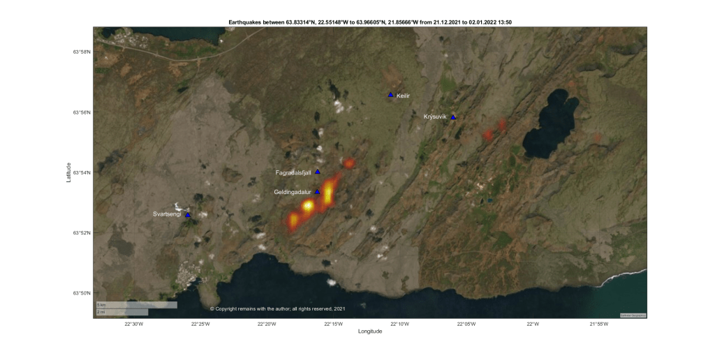
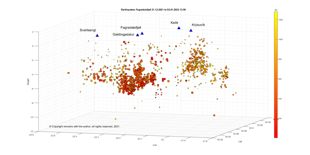
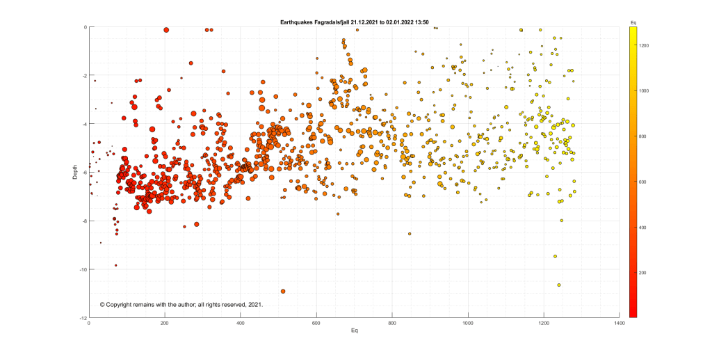
We have updated the earthquake plots for Fagradalsfjall, Iceland, for the swarm which started on 21 December 2021.
The swarm had an intense initial period while magma moved along a lateral dike, followed by a less intense period, accompanied by magma ascent. The Icelandic Met Office, IMO, say that the swarm is following the same pattern as that which preceded the eruption in March 2021.
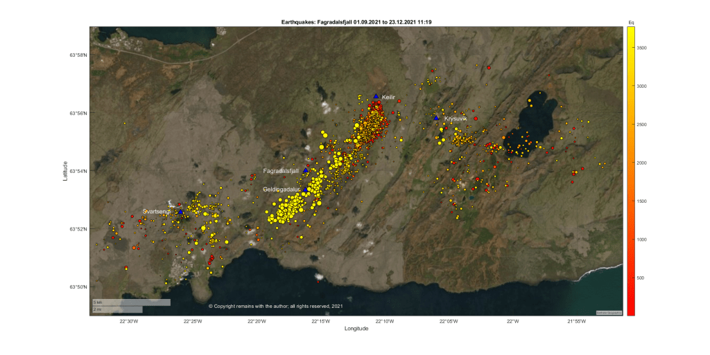
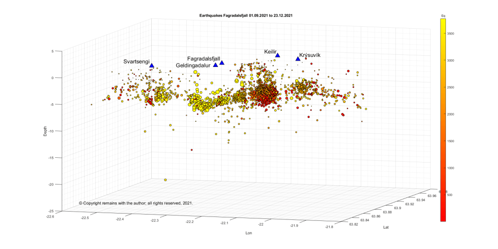
Magma is ascending under Fagradalsfjall, itself. The outlying earthquakes, e.g., at Svartsengi and Krýsuvík, are what Iceland calls triggered earthquakes. Triggered earthquakes are tectonic in nature, arising as local faults respond to magma movement.
Following a drop in seismicity over the past couple of days, visitors are now advised to avoid the area.
A similar drop in seismicity was observed immediately before the March 2021 eruption.
If the volcano does erupt again, this would be considered a new eruption in the same place; the earlier eruption was declared over three months after the cessation of activity on 19 September 2021.
Update 28/12/2021
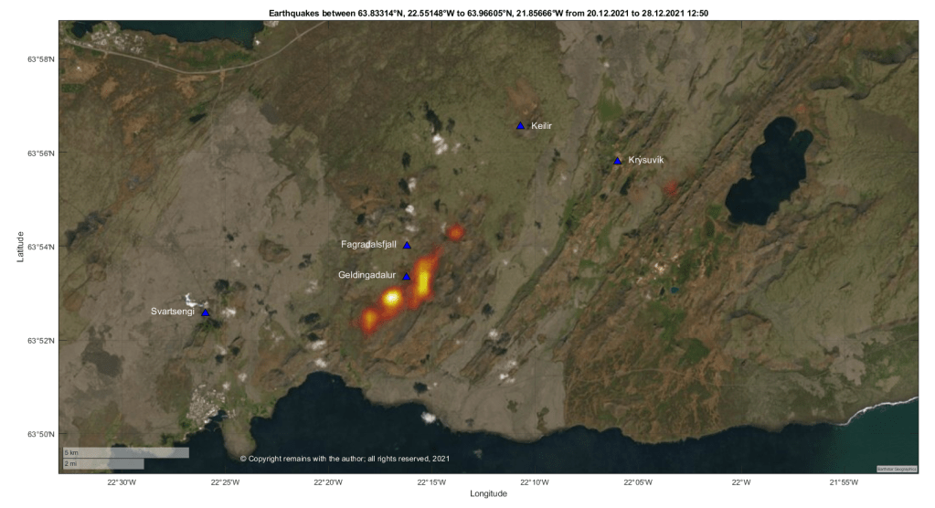
The earthquake swarm at Fagradalsfjall, Iceland, is continuing. While the swarm has slowed down a bit, 19,000 earthquakes have been recorded by the automatic SIL system since the swarm started. 14 earthquakes over 4.0 magnitude have occurred. An alert for the risk of rockfall and landslides in the area has been raised; visitors are advised to stay away from the area.
We have plotted the confirmed earthquakes from 20 December 2021 to 28 December 12:50. This shows the dike propagation south west of Geldingadalur, with additional activity near Kýsuvík and Svartsengi.
Only time will tell where and when lava will emerge. In the meantime, if you are lucky enough to be in the area, be aware of the risk of rock fall and landslip.
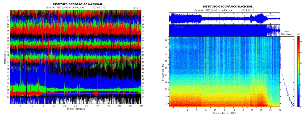
There was some good news for La Palma over the week end; the eruption was declared over on 25 December 2021. The eruption, itself, ended on 13 December 2021 at 22:21. There was a precautionary period of waiting before announcing the end of the eruption.
This is an important milestone in the process to recover and rebuild.
Fig 1: Seismic signal showing the end of the eruption. Source: IGN
Statistics
Eruption
The eruption started on 19 September 2021 as a flank eruption on the Cumbre Vieja volcano and ended on 13 December 2021. The duration of the eruption was 85 days and 8 hours – the longest for which there are historic records.
The eruptive style is described as Strombolian fissural with phreatomagmatic pulses.
The average height of the plume was 3.5km and its the maximum height was 8.5 km on 13 December 2021.
Edifice
The cone’s height is now 1,121m.
There are six craters, with diameters ranging between 106m and 172m.
Lava
200 million cubic meters erupted, covering an area of 1,219 hectares with an average thickness of 12m and maximum width of 3,350m.
The maximum temperature was 1,140°C.
Two lava deltas were created covering c. 48 hectares (one c. 43 hectares and the other 5 hectares).
Damage
2,988 buildings were destroyed and 138 damaged, according to satellite data. This is initially analysed by the local authorities as 1,345 residential properties, 180 agricultural, 75 industrial, 44 leisure, 16 public and 16 other; the shortfall is attributed to properties having more than one building within their boundaries.
Infrastructural damage includes: 73.8 km of road have been damaged along with streets and crossings; and, 130km power lines, 85 medium voltage towers, 1500 low voltage poles and 19 distribution centres.
We do not have an up to date analysis of the extent of the damage to crops and livestock.
Around 7,000 people were evacuated.
There was sadly one fatality which is under investigation.
Seismic Activity
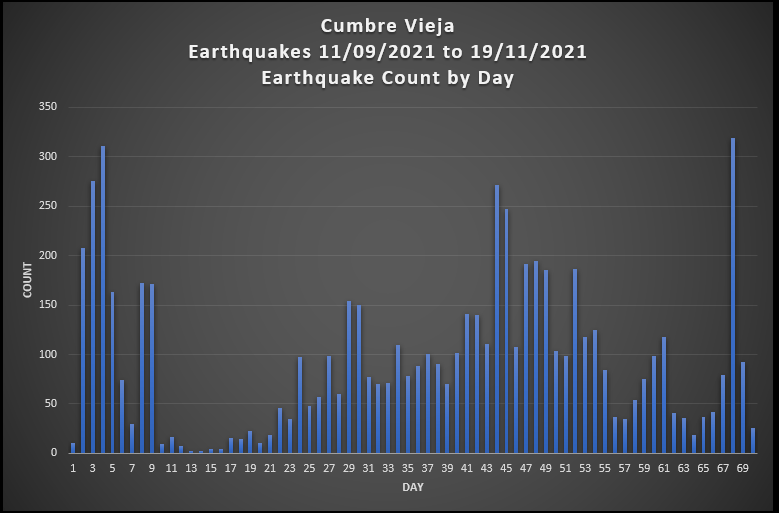
9,135 earthquakes were recorded in the period from 11 September (the onset of the swarm) and today, 27 December 2021. Due to the severity of the volcanic tremor, many smaller quakes were not recorded.
We have plotted the sequence. The results are shown in the video below.
A large earthquake swarm started at Fagradalsfjall late on 21 December 2021, 2-4 km NE of Geldingadalir, thought to be caused by a lateral dike intrusion. Due to the increased seismic activity, the aviation code was raised to Orange yesterday, 22 December 2021.
Fig 1: Icelandic Met Office, IMO’s map of the swarm. Source: IMO
The eruption at Fagradalsfjall had stalled on 18 September 2021, with no new lava flows to the time of writing. Ground deformation indicated that magma was still flowing into the crust.
Fig 2: Ground deformation at Krýsuvík. The red line denotes the start of the March 2021 eruption. Source: IMO
We have downloaded and plotted the earthquakes from 1 September 2021 to 23 September 2021 (source for raw data: IMO ). This includes the swarm which started near Mount Kelir in late September 2021, which may or may not have heralded the current reactivation of the dike.
The alert level has been lowered to Yellow. To date no eruption has followed the jökulhlaup or increased seismicity. As Grímsvötn may erupt with little warning, the situation remains closely monitored.
The alert level for Grímsvötn has been raised to orange following the draining of the caldera lake over the past few days, the resulting jökulhlaup, and increased seismicity today.
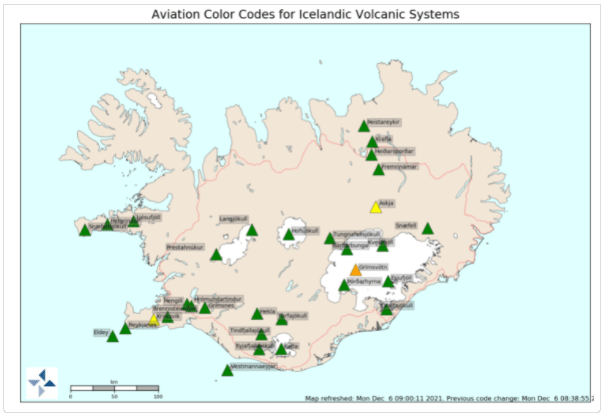
Fig 2: Aviation codes for Icelandic Volcanoes. Grímsvötn is orange. Source: IMO
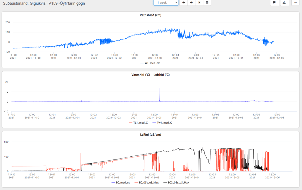
The ice-cap has subsided by c. 77 metres. The water drained via the Gígjukvísl river; the discharge in Gígjukvísl river yesterday around noon was 2800 m3/s, reducing later in the day.
Fig 3: Measurements of the jökulhlaup as it impacted the Gígjukvísl river. Source: Línurit (vedur.is)
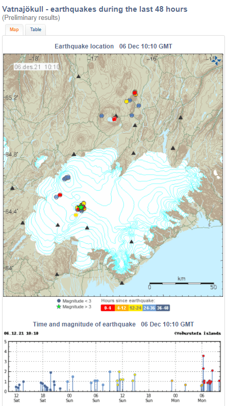
At the time of writing, there have been 25 earthquakes in the last 48 hours in the vicinity of Grímsfjall. A magnitude 2.3 occurred at 06:15, followed shortly afterwards at 06:16 by a magnitude 3.6. There have been a few aftershocks. No volcanic tremor has been detected.
Fig 4: Map of earthquakes at Vatnajökull. Grímsfjall is roughly where the green star is; the green star is the location of the 3.6M earthquake. Source: Vatnajökull (vedur.is)
Volcanic eruptions have occurred after draining of the caldera lake in the past, attributed to the sudden decrease in pressure destabilising the system; IMO cite the 2004, 1934 and 1922 eruptions.
Sadly the death toll from Mount Semeru now stands at c.40 as of noon today (local time). Over 100 have been injured.
The lava dome collapsed from 1st to 6th December 2021 generating both lava and pyroclastic flows. The largest dome collapse occurred around 14:47 on 4th December 2021 to be followed by pyroclastic flows from 15:10, causing the fatalities. Rescue efforts have been hampered by later eruptive activity.
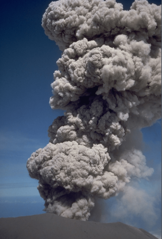
Fig 1: Image from 1985 eruption of Semeru, cropped from a photo by Tom Casadevall, 1985 (U.S. Geological Survey). Source: GVP
Sadly, 13 people have been killed, 7 missing and c. 100 injured, at the time of writing, following the collapse of the lava dome on Mount Semeru on 4 December 2021. Ash rose to a height of 50,000 feet, covering 11 villages. Flows of hot gas and lava travelled 800m at least twice on Saturday, reaching a nearby river. Two bridges were destroyed, including one connecting Lumajang to Malang. 900 people have been evacuated. 10 trapped in mines were rescued. Heavy rain and a thunderstorm had led to destabilisation of the lava dome. The volcano had been on alert level II (Waspada).
Mount Semeru is 3,657m high a stratovolcano with pyroclastic cones and fissure vents. Lake-filled maars follow a N-S trend cutting through the summit. She is located in the Lumajang district, East Java. Java lies above the subduction zone where the Indo-Australian Plate subducts under Sunda Plate . Her lavas are Andesite / Basaltic Andesite and Basalt / Picro-Basalt. Over 1m people live within 30km of the volcano.
GVP records 65 Holocene eruptions since 1818, which range from VEI 1 to VEI 3.
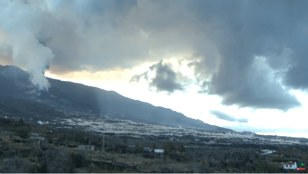
The eruption of Cumbre Vieja continues unabated with Strombolian activity, lava fountains from many vents, lava flows, and ash emissions. . As of 16 November 2021, Copernicus reported that 1,042.1 hectares of land have been covered by lava. Rainfall now adds to the hazards created by volcanic ash. The cone reached a height of 1,130m by 10 November 2021. Sadly, one fatality has occurred; one person who had gone to assist with ash clearance was found dead in his home.
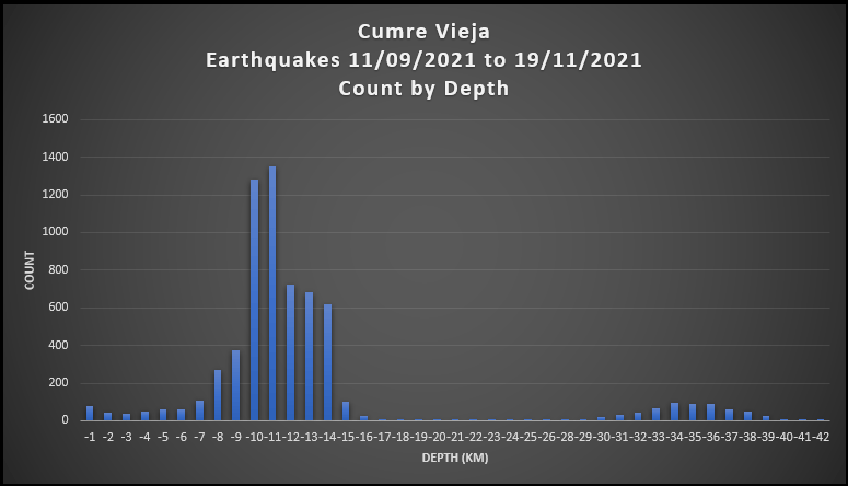
Here are updated earthquake plots. All of the action is centred around two depths: 7 -16 km and 30 -39 km, with a very few earthquakes in between; there are a few earthquakes with depths of more than 39 km.
For the updated video, we have provided the scatter plots for only earthquakes greater than or equal to 3.0 Mag. because the smaller earthquakes obscure the action; all earthquakes are included in the geoscatter plots.
Magma still appears to be stalling at the two depths: 7 -16 km and 30 -39 km prior to ascent (refer to La Palma: Earthquakes and Magma Plumbing for more information). How much of it reaches the surface remains to be seen.
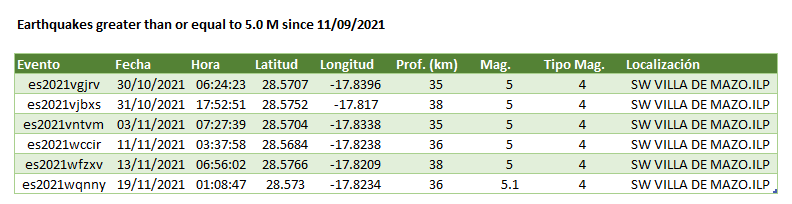
It has been a week since we updated our last earthquake plots for La Palma so time to take another look. The eruption has continued in the meantime, with seismicity and seismic signals increasing. Earthquake activity continues mainly within the two levels 7 -16km and 30 to 42km identified in our previous plots.
Several partial collapses of the main cone have occurred. The latest was yesterday, releasing a large amount of the lava to the west, which went over existing lava flows.
The latest statistics reported on 26th October 2021 are:
908.2 hectares of land have been affected by lava.
2,162 buildings haven been destroyed by lava, with a further 124 suffering damage.
66.2km of roads have been lost, with a further 3.4km damaged.
6,800 hectares of land have been covered by ashfall (reported 22nd October 2021).
Cost of lost banana plantations c.100m Euros, 150 hectares are under lava and others are in the exclusion zones; other crops, vineyards and livestock farming are also impacted.
SO2 emissions 40,800 tons per day. CO2 emissions up.
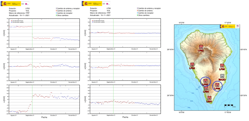
In the last 24 hours ground uplift of 10cm has been recorded at the station on the south of the volcano near the eruption site, which the volcanologists monitoring the eruption think may signal an increase in lava flow or the opening of a new vent.
Fig 2: Ground deformation at the station nearest the eruption site. We have circled the latest data point to make it easier to spot. Green line marks the onset of the eruption (added by IGN). Source: IGN
We have made geoscatter and scatter plots of the swarm from day 21, the onset of the deeper earthquakes. We have also made plots of the earthquakes over 3.0M, as these tend to get lost in the in the middle level swarm (7-16km).
There are now a few earthquakes between the two swarms but little in the way of reported earthquakes heading for the surface; the latter may mean that lava is flowing freely through the existing conduit, or that a new conduit may be in the offing. The hike in ground deformation reported above near the eruption site may indicate that whatever ensues, it is likely to be near the current eruption site – speculation on our part.
The eruption is now in its sixth week, lasting longer than recent previous eruptions, with no sign of waning. Has the initial eruption of magma created the right conditions for new magma to erupt from a greater depth, e.g. by creating a pathway for it and/or removing some of the constraining pressure? Only time, and a lot of research by the experts, will tell.
The eruption at Fagradalsfjall has halted. No lava has been erupted in the period 18 September to 18 October 2021 (or to the time of writing). The seismic swarm at Kelir has lessened. Gas emissions have decreased. The aviation code has therefore been lowered.
The eruption will not be declared over for some time. It is not possible to tell if this is a temporary lull or the eruption has ended; the eruption may resume at the same location in Fagradalsfjall or at a new fissure. As the authorities have pointed out, this can only be determined in retrospect.
The volcanic hazards are currently: gas, high temperatures both in the area and the lava field, earthquakes and rockfalls.
It’s been a few days since we looked at the latest earthquake swarm at Kelir, which is on-going. Here are the updated plots.
We have updated our earthquake plots to 19.10.2021 8:41:10. Since our previous update there has been more seismic activity, mainly between depths of 9-15km and 32- 42km. The former is consistent with the initial and subsequent stages of the swarm; the latter is consistent with the deeper earthquakes which started on day 21 (1.10.2021).
We’ve Googled around to see what’s likely to be going on at these depths. The 1585, 1949 and 1971 eruptions may shed some light on this. Researchers have found that the erupted lavas are formed by fractional crystallisation and stored in the upper mantle; during ascent, these lavas stall in the lower crust or near the Moho; there are no long-lived shallow magma reservoirs.
Fractional crystallisation is an indicator of the depths at which magma stalls in reservoirs. Earthquakes tend to occur around magma reservoirs or during the ascent of magma in response to the stresses on rock that changes in magma produce. Hence our interest in them.
The 1585 eruption produced 0.03km3 of lava, which was composed of basanites, tephrites, tephriphonolites and phonolite. The eruption is famous for the extrusion of phonolitic spines, named “Devil’s horns” by eye-witnesses, at the start of the eruption. Examination of the 1585 lavas indicate that the more evolved lavas were the result of fractional crystallisation. Magma differentiated at three levels: in the deeper mantle, c.20km depth, basanite evolved to tephrite 1550 to 1750 years, collecting in more than one reservoir, before the eruption; basanite also stagnated at the base of the crust, c.14km depth, to differentiate to tephrite; and, differentiation also occurred in the edifice. Further evolution of to tephriphonolite / phonolite may have occurred in the lower crust and upper crust. The basanite erupted may have originated from a different batch of magma than the erupted tephrite. 14km is the depth of the Moho under La Palma.
The 1949 eruption started on 24 June 1949 and ended on 30 July 1949. It had been preceded by weak seismic activity from 1936. Seismic activity picked up in February 1949, being felt mostly at the southern tip of the island and accompanied by ground cracking. Stronger seismicity and ground cracking immediately preceded the opening of the first vent. The primary melt was sourced at depths between 80-100km. Fractional crystallisation occurred at 20 to 26km with some possibly at 26-36km. Magma was stored temporarily in the crust before eruption. Magma mixing occurred in the mantle three months prior to eruption, causing a dike to propagate southwards. A 3km long fissure eruption started with the Duraznero crater emitting tephrite for 14 days. This was followed by the Llano Blanco crater opening to erupt tephrite for three days, followed by basanite for three days. The Hoyo Negra crater opened 4 days later to erupt basanite, tephrite and phonotephrite, during which the Llano Blanco crater continued to erupt basanite. The Duraznero crater then erupted basanite. The eruption started on 24 June 1949 and ended on 30 July 1949. The primary melt was sourced at depths between 80-100km. Fractional crystallisation occurred at 15 to 26km with some possibly at 36km. Magma mixing occurred in the mantle three months prior to eruption, causing a dike to propagate southwards. Magma was stored temporarily in the crust between 7-14km before eruption. Later calculations put the depth of fractional crystallisation at 35-45km.
In 1971 Cumbre Vieja erupted again, this time at Teneguía, emitting 135,000 m2 of lava and created a 290,000 m2 lava platform – 40 million m3 of lava in total. This eruption produced basanitic to phonolitic lavas. The eruption was Strombolian and in two phases: initially a 300m fissure opened on 26th October 1971, producing effusive lava flows from vents; and, new vents opened on 8th November 1971, with rhythmic explosions, lapilli, scoria and lava bombs. CO and CO2 were emitted; these gases were thought to be the cause of death for the eruptions two fatalities. Examination of the lavas showed that magma stalled at two depths: clinopyroxene and plagioclase crystallised at depths of 20-45km; and the crystallisation of aluminium augite indicated that magma then ascended to 20-35km. Variations in the samples tested indicates that magma formed in batches over a range of depths in the lithospheric mantle to combine before ascent.
Taburíente, Cumbre Nueva and Bejenado each have zones of clinopyroxene crystallisation between 25-45km. Earlier Cumbre Vieja eruptions had shallower zones of 15-30km, before the deeper zones of the 1949 and 1971 eruptions (35-45km and 25-45km, resp.). In the earlier Cumbre Vieja eruptions magma stalled beneath the Moho and the in the later eruptions magmas depths were more in line with Taburíente, Cumbre Nueva and Bejenado.
How does this Compare to the Current Earthquakes?
To make any conclusions we need to wait until there is a detailed analysis of the erupted lavas. However, we can note that the current earthquakes are at two distinct depth ranges: 7 -16km and 30 to 42km, with not much in between. 7-16km correlates to a possible zone of magma storage beneath the crust and magma migration through the crust. 30 to 42km correlates to part of the lower zone of fractional crystallisation of the 1949 and 1971 magmas.
Time will tell how this eruption will pan out. In the meantime, the eruption is still going strong. Our thoughts continue to be with those affected.
Kursten Galipp, Andreas Klügel, Thor Hansteen, “Changing depths of magma fractionation and stagnation during the evolution of an oceanic island volcano: La Palma (Canary Islands)”, Journal of Volcanology and Geothermal Research Volume 155, Issues 3–4, 15 July 2006, Pages 285-306. Link: Source
T. S. Johansen F. Hauff K. Hoernle , A. Klügel, T.F. Kokfelt, “Basanite to phonolite differentiation within 1550–1750 yr: U-Th-Ra isotopic evidence from the A.D. 1585 eruption on La Palma, Canary Islands”, Geology; November 2005; v. 33; no. 11; p. 897–900. Link: Source
Andreas Klügel , Kaj A. Hoernle, Hans-Ulrich Schminck , James D. L. White, “The chemically zoned 1949 eruption on La Palma (Canary Islands): Petrologic evolution and magma supply dynamics of a rift zone eruption”, Journal of Geophysical Research, Vol 105, No. B3, Pages 5997-6016. Link: Source
Abigail K. Barker, Valentin R. Troll, Juan Carlos Carracedo, Peter A. Nicholls, “The magma plumbing system for the 1971 Teneguía eruption on La Palma, Canary Islands”, Contributions to Mineralogy and Petrology 170, Article number: 54 (2015). Link: Source
The eruption at La Palma is continuing unabated, sadly with more evacuations for areas in the path of the lava.
Let’s take a moment to look at her fellow island, El Hierro. La Palma and El Hierro occupy the same N-S line at the western end of the Canary Island archipelago: La Palma to the north and El Hierro to the south. El Hierro experienced a N-S aligned fissure eruption between October 2011 and March 2012.
Fig 1: La Restinga as seen from the harbour wall. Image captured from Google Maps, 2021.
Background
El Hierro is a shield volcanic island which formed around 1.2 million years ago. It is made up of three volcanoes, Tiñor, El Golfo, and, later rift volcanism.
The island has a population of c. 10,000. The capital is Valverde, located near the eastern end of the island. The earliest known inhabitants were the Bimbaches, thought to be descendants of the Guanches who had migrated from Tenerife. Sadly, many of the Bimbaches were sold as slaves by the son of the first Spanish conquistador. The island was then populated by both the Spanish and Normans. Some the slaves were later returned to the island having won their freedom.
The island’s climate is influenced by the Trade Winds. Warm moist air is deposited on the northern side of the island. The climate varies from warm-summer Mediterranean climate in the centre of the island, to mild semi-arid and to a tropical mild, desert climate on the coasts.
The island, home to endemic species such as the endangered El Hierro giant lizard, has been designated as a Biosphere by UNESCO to preserve its natural and cultural diversity.
Fig 2: The island of El Hierro. Image captured from Google Maps, 2021. El Golfo, El Julan, Las Playas and Tiñor added by the author. The embayment of El Golfo can be seen as the cliffs encircling La Frontera.
Tiñor was the first subaerial volcano to emerge, comprising primitive basalts to trachybasalts and tephrites. It is dated between 1.2 – 0.88 million years old, having developed rapidly in the Lower and Middle Pleistocene. It has three units: the lowest unit with steep sides and thin steep-dipping lava flows; a middle unit of thicker lavas; and, an uppermost unit, the Ventejis Group, with craters After the emergence of the Ventejis Group, the north western flank of Tiñor suffered a large gravitational collapse which may have taken out more than half of the Tiñor edifice.
The El Golfo volcano emerged c. 545,000 years ago, located near the current town of Frontera. This volcano has two identifiable layers: a lower unit made up of basalt Strombolian and Surtseyan pyroclasts with dykes implying the presence a triple rift system; and, the upper unit made of lava flows, overlain with trachybasalts and trachyte lava flows and block-ash deposits. The youngest lavas are the trachyte, aged at c. 176,000 years. Gravitational collapse of the southwestern flank of the volcano occurred at El Julan.
The San Andrés fault system on the north east rift developed between 545,000 -176,000 years ago. The presence of cataclasites and pseudotachylytes, rocks typically found in the early stages of volcanic collapse indicate that there was incipient gravitational collapse that did not develop further. Cataclasites are formed through faulting or fracturing in the upper crust. Pseudotachylytes may be formed by frictional melting of the wall rocks during rapid fault movement during an earthquake.
The impressive El Golfo embayment resulted from gravitational collapse of the El Golfo volcano. This may have occurred in a single or multiple events. One possible is scenarios is that an initial subaerial lateral collapse of the volcanic edifice occurred 130,000 years ago and a second one occurred 17,000 – 9,000 years ago affecting the submarine lava platform.
Rift volcanism, defined as when the three arms of the rift were active at the same time without a central vent, occurs along the three arms of the island, with vents occur along the ridges of the rifts. Before the 2011-2012 eruption, rift volcanism had been dated to between 134,000 years ago to 500BC. GVP lists 6 eruptions prior to the 2011-2012 eruption: 3 confirmed in 550BC, 950BC and 4790 BC; and, 3 unconfirmed in 1793, 1692 and 1677. The associated lavas are alkaline picro-basalts, basanites and tephrites.
2011 -2012 Submarine Eruption
Fig 3: Stain from the submarine eruption south of the island. Image cropped from NASA Earth Observatory EOSDIS on 10 February 2012. Source: El Hierro Submarine Eruption (nasa.gov). “El Julan” and the “Eruptive vent” added by the autho
In 2011 a submarine flank eruption commenced, preceded by an intense seismic swarm. The submarine cone has been named Tagoro, from the Guanche language for meeting place or circular enclosure of stones.
Build up to the eruption
Before the eruption, El Hierro had been quiet since a seismic episode in 1793, which may or may not have been connected to an eruption. In the absence of eye-witness accounts then, it has been suggested that there was an eruption of Lomo Negro volcano, a submarine eruption or a magma intrusion.
Fig 4: Crater of Tanganasoga. Image cropped from one by Areuland, 5th January 2017. published under CC BY-SA 4.0. Source: Wikipedia
In July 2011, a seismic swarm started under El Golfo at a depth of 20-25km. Seismicity then ascended to 11±3km and headed southward across the island, after which it ascended to 3km between 8-9 October prior to the eruption on 10 October 2011. A 4.4M earthquake at a depth of 10km 1.5km south of La Restinga preceded the eruption. Magma had risen under Tanganasoga, the main volcano on El Hierro, to migrate south towards La Restinga.
Basanite fractionation and magma replenishment may have occurred during these seismic swarms while magma was being injected into the lower crust.
The eruption
The eruption occurred in phases.The lavas in the first phase were evolved basanites. The second phase was more primitive lava with 8-9 wt% MgO.
A harmonic tremor started on 10 October 2011 between 04:15 and 04:20 and is thought to indicate the start of the eruption. Magma had risen from the base of the ocean crust to the vent in c. 30 hours. Areas of discoloured, sulphurous-smelling water and dead fish were seen off the coast of La Restinga. Vigorous bubbling in the sea resembling a jacuzzi was observed above the vent, caused by gas emissions and heat from the vent; bubbling reached several metres high on occasion.
On 15 October 2011, lava bombs were observed. These comprised white to grey pumice encased in black basanite lava. Basanites are typical of the western Canary Islands. A small amount of U-depleted rhyolite was found in the lava bombs, though to have originated from differentiated trachyte incorporating quartz-rich sediment during melting when mobilised by the basanite. The boundary between old oceanic crust, continental crust and volcanic island may act as a magma trap where sediments can be assimilated. A few days later basanite lava balloons were emitted.
The second phase of the eruption started in November 2011 with seismicity at depths of 10-15km and a decrease in tremor intensity. This correlated with the eruption of more primitive lavas.
During November 2011, the eruption was confirmed as Surtseyan. Several plumes of material aligned N-S were visible from the air, confirming a fissure eruption. Tanganasoga experienced rapid inflation and released CO2. On 24th November a sulphur smell was reported in El Golfo. On 4th December 2011, vigorous phreatic bubbling (“the jacuzzi”) was observed. In December 2011, there was a temporary lull: the harmonic tremor and seismicity decreased.
The eruption picked up again in January 2012 with increased seismicity, a larger area of eruption and pumice clasts. In late February 2012, seismic activity, deformation and gas emissions decreased. The eruption was declared over in March 2012.
Tagoro’s cone was found to be 85m below sea level in April 2012. The eruption has been classified as a VEI 2.
Post eruption
Magma movements were detected from seismic swarms. In June 2012,accompanied by rapid inflation, magma moved south-westward towards El Julan-La Dehesa, northwest of the submarine vent. Earthquakes picked up again in September 2012 indicating magma movement under Tanganasoga.
The last reported seismicity was in March 2013 when another swarm occurred near the NW tip of the island, initially at 20km depth, migrating westward at a depth of 12-15km. The swarm was accompanied by inflation and CO2 emissions.
Plotting Seismicity
We have downloaded the earthquake data from IGN’s publicly available database and plotted the earthquake swarms for the period July 2011 to December 2012. The results are shown in the video below.
Only time, and a lot of work by the various scientists studying the eruption on La Palma, will tell how many similarities are shared between the two eruptions.