An earthquake swarm started near the Reykjanes and Eldey volcanic systems on 17th April 2022. A volcanologist was reported by the Icelandic media to have said that there is a 50% chance of another eruption on the Peninsula by the end of this year. If the eruption occurs offshore, the resulting ash may reach Reykjavik and beyond. Another possibility is that Fagradalsjall may erupt again.
Fig 1: Image of Eroded partially submarine volcano and boulder beaches at Reykjanestá by Diego Delso. Published under CC BY-SA 4.0. Source: Geology of Reykjanes Peninsula – Wikipedia
So we decided to plot the earthquakes on the Reykjanes Peninsula from 1st January 1995 to 26th April 2022 for the area 63.6°N, 23.5°W to 64.2°N, 21.0°W by month. The results are interesting.
Intense earthquake activity starts early 1995 in the east of the region to the south east of Hengill near the Hrómundartindur volcanic system, which has not erupted since the early Holocene. Activity migrates slowly westward to Geirfuglasker via Krýsuvík, Fagradalsfjall, Reykjanes, and the intensity of activity near Hrómundartindur lessens. The volcano-tectonic episode which resulted in the eruption at Geldingadalir started in month 300, the eruption, itself, started in month 315.
We have discussed the Hengill, Brennisteinfjöll, Krýsuvík and Reykjanes volcanic systems in an earlier post (Recent Seismic Activity on the Reykjanes Peninsula, 14th May 2020) The Hrómundartindur system is about 25 km long, comprising a fissure swarm and a 500m high central volcano. The system lies at the junction of the Western Volcanic Zone and the South Iceland Seismic Zone. Its lavas range from picrite to basaltic andesite. There is an active geothermal field in the system. The Eldey volcanic system is a 40km long fissure system on the Mid Atlantic Ridge, here, the Reykjanes Ridge. There is no central volcano. It is mostly submarine; the island Eldey and the skerries, Eldeyjardrangur, Geirfugladrangur and Geirfuglasker, are the only subaerial features of the system. Six small submarine/explosive Basaltic eruptions have occurred in the last 1,100 years, the last eruption occurring in 1926 CE.
We would not like to predict where the next eruption will be based on the above earthquake plots alone, other than to say it could be anywhere between Hrómundartindur and Geirfuglasker. Our non-expert interpretation of the above plots is that magma is ascending between Krýsuvík and Reykjanes. The seismic activity to the east and west of that area is caused by resulting stress on the crust; whether there is enough activity to provide an additional path for magma remains to be seen. Time will tell where and when magma makes it to the surface again.
Kristján Sæmundsson (Iceland GeoSurvey) (2019 November 15). Hrómundartindur. In: Oladottir, B., Larsen, G. & Guðmundsson, M. T. Catalogue of Icelandic Volcanoes. IMO, UI and CPD-NCIP. Retrieved from http://icelandicvolcanoes.is/?volcano=HRO
Guðrún Larsen (Institute of Earth Sciences – Nordvulk, University of Iceland) (2019 November 15). Eldey. In: Oladottir, B., Larsen, G. & Guðmundsson, M. T. Catalogue of Icelandic Volcanoes. IMO, UI and CPD-NCIP. Retrieved from http://icelandicvolcanoes.is/?volcano=ELD
The earthquake swarm is continuing on São Jorge as we write, albeit it at a much lower intensity. The swarm is located on the Manadas Fissure system. INVOLCAN has sent a team to assist the local scientists (CIVISA and IVAR). CIVISA advised on 6 April 2022 that volcano-tectonic earthquakes had been detected suggesting magma movement at depth.
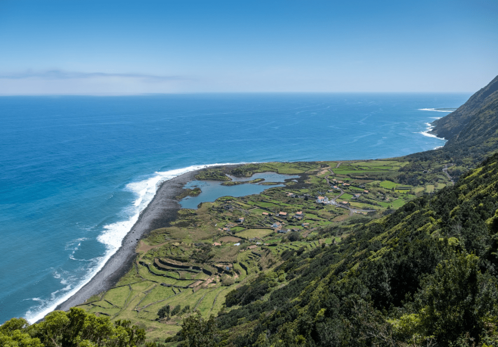
Fig 1: Image of Fajã dos Cubres, São Jorge, Azores, cropped from one by Jules Verne Times Two. Published under CC BY-SA 4.0 (Source: São Jorge Island – Wikipedia).
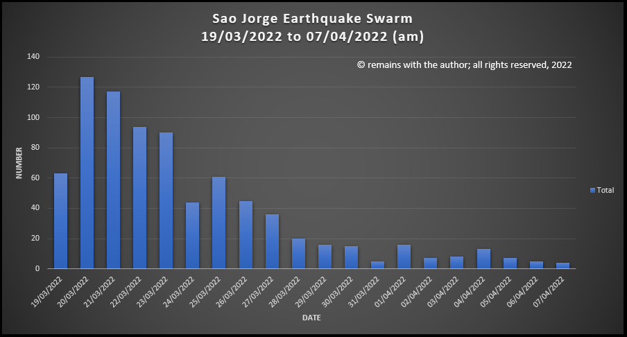
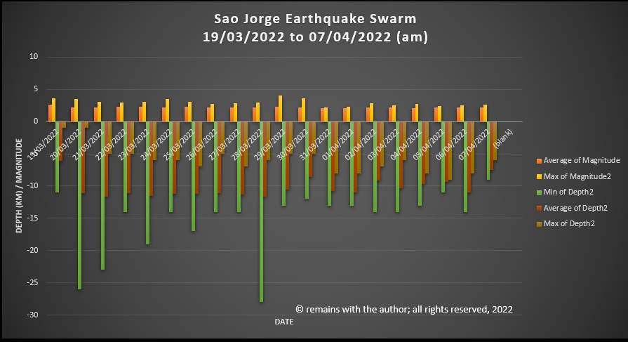
While we wait to see what transpires, here are some statistics.
Number of earthquakes ≥2.0 reported on IPMA’s site: 793
Maximum number: 127 on 20 March 2022
Minimum number: 5 on 31/03/2022 and 06/04/2022 (7/04/2022 is not a complete day)
Maximum magnitude: 4.0 (29/03/2022, 21:56:16, 38.686°N, 28.215°W, 10km)
Maximum depth: 26km on 20 March 2022 and 28km on 28 March 2022.
Good Afternoon! (Updated 30/03/2022 to include Background)
On 19 March 2022 an earthquake swarm started on São Jorge, an island in the Azores. The swarm is ongoing at the time of writing. By 28 March 2022, c.14,000 earthquakes had been recorded. This swarm is likely to be caused by a magmatic intrusion.
Fig 1: Image of Fajã dos Cubres, São Jorge, Azores, cropped from one by Jules Verne Times Two. Published under CC BY-SA 4.0 (Source: São Jorge Island – Wikipedia).
INVOLCAN have estimated that up to 20 million cubic meters of magma may have accumulated under São Jorge during the swarm, based on satellite measurements of ground deformation. CIVISA (Centro de Informação e Vigilância Sismovulcânica dos Açores) has raised the alert level to V4 (out of a scale to V6. V5 and V6 are in eruption, based on size of the eruption).
There are four likely outcomes:
An eruption occurs in the next few days to weeks, possibly with little warning.
A larger earthquake occurs alongside changes in the magma intrusion leading to an eruption or stalling of the intrusion.
The current swarm and deformation end without eruption. Future swarms and deformation lead to an eruption.
The activity ceases and the intrusion cools with no further activity.
Locals have been advised to prepare to evacuate due to the risk of eruption or larger earthquakes. Our thoughts are with them.
Let’s take a look at what is going on underground. We have downloaded the earthquake data reported by The Portuguese Institute for Sea and Atmosphere, I. P. (Source: IPMA – Seismic map). This shows earthquakes ≥2.0 magnitude. At the time of our download c. 840 earthquakes ≥2.0 had been recorded for São Jorge from 19/03/2022.
Our video shows geoscatter plots by day, showing the north-westward migration of the swarm, and 3D rotating scatter plots.
Around 8,400 people live on the island in settlements around the coast. Transport links have historical been by sea as land transport was inhibited by the harsh volcanic terrain. The economy is reliant on dairy farming, including the export of São Jorge cheese, fishing and some cereals, vineyards and local vegetables. The opening of an airport in 1982 led to the expansion of the export of cheese, farming and small crafts.
São Jorge Island, itself, is 55km long and 6km wide volcanic ridge in the Azores Archipelago. The Azores are located at a triple junction between the North American, Eurasian and Nubian Plates; the Mid Atlantic Ridge forms the eastern boundary of the North American Plate. The Azores Plateau is considered to be a large igneous province generated from a plume interacting with the Mid Atlantic Ridge between 20 and 7 million years ago. Fissural volcanic activity arising from the interaction and tectonics created the islands.
There are four known centres of volcanic activity on São Jorge: the São João area on the south eastern end of the island; the Topo Volcanic Complex, occupying most of the eastern side of the island; the Rosais Volcanic Complex, with basalt and andesites; and Manadas Volcanic Complex on the west side of the island. The earliest known subaerial lava is alkaline enriched c.1.32 – c.1.21 million years old from deep partial melting of an enriched garnet peridotite mantle source. This is located at the south east end of the island at São João with a NW-SE to NNW-SSE direction oblique to the current WNW -ESE axis of the island. The period includes at least thee episodes of magma differentiation from alkaline basalts to mugearites in a shallow magma reservoir. Subaerial activity resumed c. 750,000 years ago at the Topo Volcanic Complex, with several overlapping episodes migrating westward along the axis of the island. Activity in the western side of the island started c. 731,000 years ago. The lavas generated 750,000 years ago and subsequently were also generated from an enriched mantle source. The different phases of subaerial growth are attributed to different episodes of deformation reopening the magma feeding system. It is possible that submarine activity occurred during the period of apparent quiescence.
GVP lists 11 confirmed Holocene eruptions for São Jorge, of which one is VEI 3 (1580), one is VEI 2 (1800) and one is VEI 1 (1808). Three are submarine: 1964, off the SW coast; 1902, off Ponta do Topo; and, 1800, also off Ponto do Topo. The eruptions in 1580 and 1808 caused widespread damage. In the 1580 eruption, magma ascended from 23km or more, ponded at 16km and then erupted in three lava flows along the Ribeira da Almeida, Queimada and between Ribeiro do Nabo and the beach of Cruzes; ten people were killed. In the Urzelina eruption in 1808 , fractionated residual ponded magma from the 1580 eruption emerged as andesite-basaltic lava to flow south west of Pico do Pedro to Urzelina. This eruption caused gases and chloric, sulfuric and carboxylic acid vapours to be emitted from the Manadas Ridge, which along with eight large earthquakes, caused significant damage to property and farmland. Eight people were killed in the 1808 eruption.
The island and surrounding area is heavily faulted. Submarine fractures between the São Jorge and Pico have resulted in large damaging earthquakes. In 1757, an earthquake centred in Fajã dos Vimes resulted in destruction of property in Manadas and the death of c. 20% of its population (1,000 people).
A series of seismic swarms in February 1964 associated with an offshore eruption 6.5km northwest of Velas led to large earthquakes which destroyed most property in the western side of the island. The eruption was preceded by seismic activity starting tremors felt on 21 August 1963, followed by a swarm which lasted from mid-December 1963 to January 1964 and the cutting of submarine cables on 29 January and 1 February 1964. Volcanic tremors started on 14 February 1964, resulting in a large damaging earthquake on 15 February after a lull in activity. The earthquakes initially impacted Urzelina, Manadas, San António and Norte Grand before migrating north west to include Rosais, Beira, Velas, and Santa Amaro. Low intensity tremors occurred in the period before the next large events on 21 February 1964 when three large tremors caused more damage; this phase ended on 24 February 1964. Earthquake foci near the centre of the island had depths of 5km, whereas those near Velas were 10-20km in depth. Neighbouring islands also experienced large tremors. The event ended on 25 February 1964. 5,000 people were evacuated from the island during this time, not an easy task as storms in the channel between Terceira, Pico an b d Faial hampered relief efforts, along with lack of planning. This time with monitoring the authorities are better prepared.
Time will tell when the next eruption occurs on São Jorge. In the meantime, here’s hoping that the disruption to local residents is short-lived.
Anthony Hildebrand, Pedro Madureira, Fernando Ornelas Marques, Inês Cruz, Bernard Henry, Pedro Silva, “Multi-stage evolution of a subaerial volcanic ridge over the last 1.3 Myr: S. Jorge Island, Azores Triple Junction”, Earth and Planetary Science Letters, Volume 273, Issues 3-4, 15 September 2008, Pages 289 -298.
Anthony Hildebrand, Dominique Weis, Pedro Madueira, Fernando Ornelas Marques, “Recent plate re-organisation at the Azores Triple Junction: Evidence from combined geochemical and geochronological data on Faial, S. Jorge and Terceira volcanic islands”, Lithos, 210-211, (2014), 27-39.
Vittorio Zanon, Fátima Vieros, “A multi-method re-evaluation of the volcanic events during 1580 CE and 1808 eruptions at São Jorge Island (Azores Archipelago, Portugal), Journal of Volcanology and Geothermal Research, Volume 373, 15 March 2019, Pages 51–67.
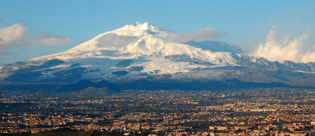
Fig 1: Cropped image of Mount Etna with Catania in the foreground from a photo by BenAveling in 2007, published under CC BY-SA 4.0. Source: Mount Etna – Wikipedia
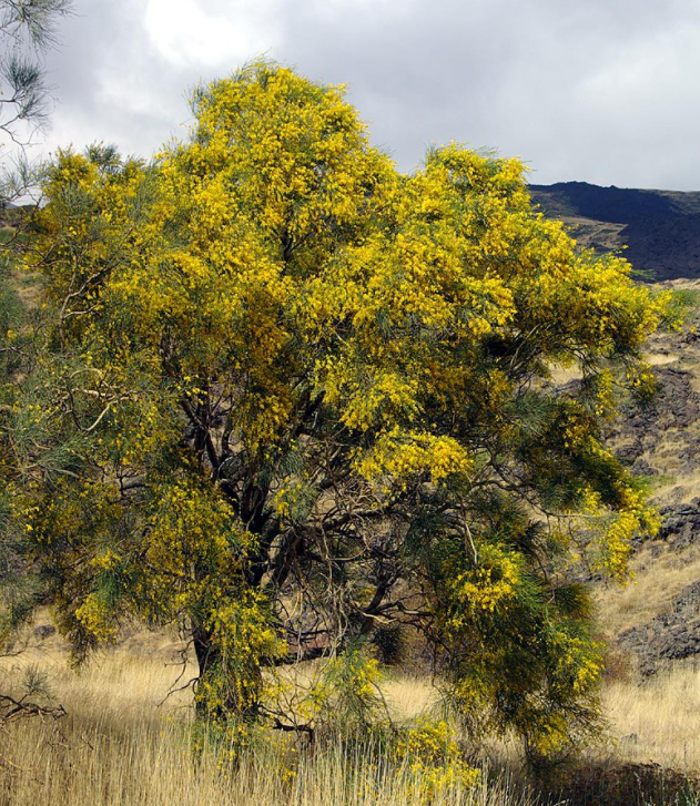
Today we are looking at Mount Etna, Europe’s largest and most active volcano, sited on the eastern side of Sicily. Sicily has been at the heart of many Mediterranean trading routes. As a result, the volcano has been widely studied. Etna has been designated a Decade Volcano by the UN. She is home to indigenous species, Etna Broom, which thrives on its lower slopes. In 2013, she was designated a UNESCO World Heritage Site.
Apart from the widely reported recent activity, she caught our eye because of the interesting tectonic setting between the African Plate, Eurasian Plate, Adriatic Plate and additional micro-plates. The area has some of the deepest subduction in the Mediterranean region. We start with her tectonic setting.
Mount Etna is a c.3,320m high complex volcano with four summit craters: the North East, Voragine, Bocca Nuova and the South East Craters and many cinder cones. The volcano is made up of an old shield volcano, topped by stratovolcanoes, Ellittico and Mongibello. It is truncated by small nested calderas.
The volcano has erupted basalts, viscous granitic lava, trachyte and again basalt. The last is rich in iron with microscopic gold particles. The basalt is used for building and sculpture. Until health and safety concerns banned it, the fluid lava was collected to be made into souvenirs for tourists.
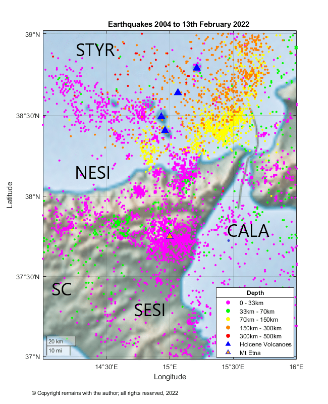
The source for Etna’s lavas is not clear. You will see from our earthquake plots below that there is little evidence of subduction beneath Etna, herself, although there is clear evidence of subduction beneath the neighbouring Aeolian Arc. Various theories have been proposed: rifting; a hot spot; and, the intersection of breaks in the crust associated with the subduction of the African Plate under the Eurasian Plate, providing a channel for magma.
Tectonic Setting
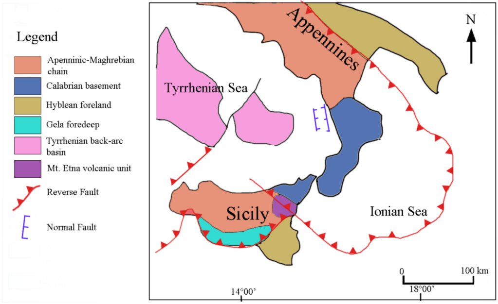
The collision of the Eurasian and African Plate has a complex history. In the vicinity of Sicily, the Tyrrhenian and Ionian Seas opened, the Aeolian – Calabrian Arc suffered subduction, bending and compression and the edge of the Eurasian Plate was thrust over the edge of the African Plate. The Adriatic Plate broke off and the Ionian Plate was subducted under the Tyrrhenian Sea.
Sicily
The main tectonic features of Sicily are the crystalline units of the Calabrian arc; the Neogene Maghrebian fold and thrust belt created during the opening of the Tyrrhenian Basin; the Catania – Gela foredeep; and the Hyblean Plateau.
The Calabrian Arc unit is located in the north eastern part of Sicily. It is the tectonic unit that connects the Apennines with the North African Maghrebide. The Arc migrated to the south east, driven by the subduction of the Ionian slab east of Sicily. In the early Miocene, Calabria was attached to Sardinia. Trench roll back to the east and extension in the middle Miocene, caused Calabria to break off from Sardinia. By the early Pliocene, back arc volcanism relating to subduction of the Ionian slab had created new crust in the Tyrrhenian Sea. From the Pleistocene, the eastern portion of the Arc formed the Apennine mountains in Italy, while the Calabrian block had migrated to Sicily. The migration is ongoing. Palaeozoic igneous and metamorphic basement rocks are exposed at this part of the island. Triassic late Cretaceous carbonate is overlain by Paleogene – Middle Miocene turbidites, Middle Miocene to – Messinian rift deposits, Messinian evaporites and early Pliocene chalk.
The Maghrebian fold and thrust belt, part of a subduction regime, comprises frontal accretion and detached nappes of Mesozoic carbonate, which has been folded in to a syncline, underlying the anticline of the Caltanissetta region.
The Catania – Gela foredeep extends from the northern margin of the Hyblean Plateau to the offshore Gela basin of southwestern Sicily. It was formed due to bending of the carbonate platform caused by loading at the front of the Gela nappe. In the late Miocene – Pleistocene sediments were deposited, including limestones, evaporites and sandy clays.
The Hyblean Plateau is on the Nubian Plate. In the early Miocene, regional uplift caused by thrusting and volcanism resulting in the emergence of a carbonate platform in the eastern Hyblean Plateau. In the late Miocene, sea level fall and uplift caused the deposition of evaporites in the Mediterranean basin. This was followed by subsidence in the foreland and deposition of sediments. In the late Miocene – early Pleistocene, basaltic volcanic activity occurred; alkaline basalts were erupted during the late Miocene. In the late Pliocene, large volumes of tholeiitic basalt was erupted and the foredeep north of the Hyblean foreland collapsed.
Mastrolembo et al(1) found evidence for independent lithospheric blocks by studying GPS velocities relative to the Eurasian and Nubian Plates. The Sicilian domain rotates clockwise with respect to Eurasia and is fragmented into three distinct blocks: the south eastern, the central and the north eastern Sicily blocks, which move independently from the African Plate.
Deep faults transect the island. Currently, the Tyrrhenian side of Sicily is being compressed and the Ionian side extended. Mount Etna, itself, is located near to the junction of three major lithospheric faults which may reach the mantle: the east to west Mt Kumeta -Alcantara fault; the north -northeast to south-southwest Messina – Giardini fault which delimits the north coast of Etna; and, the Aeolian-Maltese fault which extends from Vulcano to Malta.
Mount Etna’s History
Mount Etna is a complicated volcanic system; she is thought to have evolved in four stages: 1) tholeiitic basalt; 2) Timpe shield-building; 3) Valle del Bove Central Volcanoes; and 4) Stratovolcanoes.
Tholeiitic Basalt Stage
Earliest activity at Etna has been identified as being the sporadic eruption of tholeiitic pillow lavas from fissures more than 500,000 years ago in the submarine environment of the Gela-Catania foredeep basin at Aci Castello. 300,000 years ago, Na affinity lavas were erupted in fissure eruptions on the alluvial plain of the Simento River, forming a lava plateau.
Timpe Shield Building Stage
220,000 years ago, extension tectonics of the NNW-trending Timpe fault system drove activity. Sub alkaline – Na alkaline were lavas erupted in fissures along the Ionian coast built a 22 km NNW -SSE aligned shield volcano. Volcanic activity also occurred to the south west and south east of the location of the now current edifice. 129,000 to 126,000 years ago, activity shifted to a location at the central portion of the location of the current volcano.
A 15km horseshoe depression in the east flank of the edifice was created during this period. The edifice rested on basement rocks of Miocene argillaceous turbidites in the north and west, but on Pleistocene clay rich marine sediments to the south and the east. The clays were unable to support the weight of the edifice, resulting in slippage and subsidence to the east.
Valle Del Bove Central Volcanoes Stage
During this period magma ascent through the crust became more localised, allowing the building stratovolcanoes. Several monogenetic volcanoes are visible in the Valle del Bove scars. Na-alkaline lavas were erupted.
121,000 years ago, effusive eruptions occurred on the southern edge of the volcano in the N – S aligned Tarderia and Rocce volcanoes in the Valle Del Bove area. Activity at Tarderia and Rocce ended between 106,000 and 102,000 years ago, respectively.
Trifoglietto volcano was also active at this time. While the onset of activity at Trifoglietto is not known (there are no rocks outcropping to date), activity is believed to have ended c. 99,000 years ago with explosive benmoreitic Plinian eruptions.
Activity then shifted to Monte Cerasa, Giannicola, Salifizio and Cuvigghiuni volcanoes. Monte Cerasa volcano is a large composite stratocone in the central part of the present Valle del Bove with explosive eruptions and pyroclastic flows which transitioned to more effusive eruptions. Activity ceased here 93 ka ago. Giannicola volcano is a 300 m neck intruded in the northern flank of Trifoglietto volcano about 85 ka ago followed by alternating pyroclastic deposits and lava flows. The main vent Salifizio volcano was located 1 km east of Trifoglietto. She produced effusive lavas that covered the eastern sides of Trifoglietto and Monte Cerasa. Cuvigghiuni erupted intrusive bodies into the western side of Trifloglietto, followed by lava flows , spatter deposits and pyroclastic flows between c. 80,000 and 65,0000 years ago. The final stage of her activity was effusive lava flows.
The Valle Del Bove, itself, was created during this period. Subsidence of the Trifloglietto volcano to the east led to reduction in magma pressure, successive violent hydro-magmatic eruptions and debris avalanche flows which carved out the Valle.
Stratovolcanoes Stage
In the fourth phase of growth , c. 60,000 years ago, Etna’s magmatic plumbing system had stabilised at its current position. Two overlapping stratovolcanoes were formed, which form the current upper edfice: Ellittico between 60,000 and 15,000 years ago and Mongibello from 15,000 years ago to present. Ellittico erupted trachybasalt, followed by mugearites, benmoreites and trachytes, reaching a height of 3,700m before 4 caldera-forming Plinian eruptions signalled the end of activity at Ellittico.
From 15,000 years ago to present, activity at Mongibello has been a mix of lava flows and a few Plinian to sub-Plinian eruptions of basaltic / picritic magma. Silicic eruptions occurred in 8,460, 7100, 6100, 5000 and 4280 years ago. In 122BC a Plinian eruption formed the Cratere del Piano, the summit caldera. Other eruptions were basaltic, filling the caldera and building the cone.
GVP lists 241 Holocene eruptions for Etna, of which 196 have been confirmed. These include 2 VEI 5, 1 VEI 4, 26 VEI 3, and 167 VEI 2 or less. The VEI 5’s are the 122BC Cratere del Piano and another in 1500 BC.
Subsidence is continuing on the eastern flanks of the edifice, creating a series of rift faults and fault scarps.
Recent Seismicity
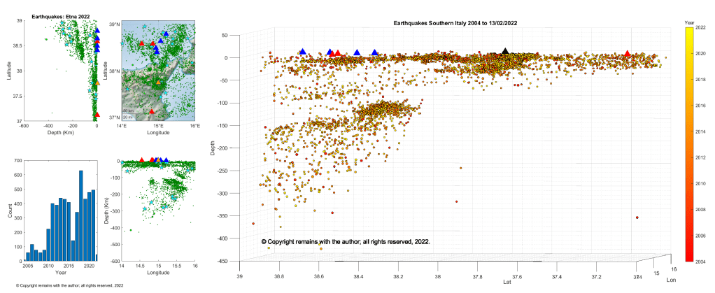
We have plotted earthquakes downloaded from EMSC for the period 1st October 2004 to 13th February 2022 for the area 37°N, 14°E to 39°N, 16°E.
There is little evidence of a Wadati-Benioff zone under Etna, although the area is seismically active. Our plots clearly show the subducted Ionian slab under the South Tyrrhenian Sea.
At the end of 2021 a large earthquake swarm started to the west of the Ok shield volcano in Iceland. At the time of writing the swarm is ongoing. The Icelandic Meteorological Office (IMO) reported on their Icelandic site on 1st February 2022 that there is no evidence of magma intrusion.
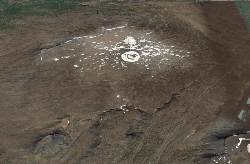
Fig 1: Ok volcano looking northwards, with a small tuya in the foreground. Image from Google Earth. The remnant of the Okjökull glacier is visible with a small lake in its centre at the summit of the volcano. The current swarm is to the west of the volcano.
The swarm is occurring west of Ok in Borgarfjörður in a low temperature region outside the main volcanic and rift area. The earthquakes are thought to be rifting caused by horizontal tension in the crust, here of the North American Plate. The swarm is the largest to date in the region and is continuing at the time of writing. So off we trotted to plot the earthquakes.
What’s in the Area?
We looked at the area 64.2°N, 19.2°W to 65.3°N, 21.8°W which contains the Langjökull ice cap, two Holocene volcanic systems and several Pleistocene volcanic systems.
The Langjökull ice cap is the second largest ice cap in Iceland located at the northern end of the Western Volcanic Zone (WVZ). The WVZ is a slow spreading rift that forms the western boundary of the south Iceland microplate. Sinton et al.’s study in 2005 showed that there is no evidence for the decline in the WVZ in the Holocene; the shield eruptions are long duration with low effusion rates fed by magma from the mantle. c. 40 eruptive units have been located in the WVZ; we are focussing on those in the Langjökull area in the northern part of the zone.
Holocene Volcanoes
Volcano
Latitude
Longitude
Last Known Eruption
Dominant Rock Type
Prestahnúkur
64.583
-20.666
3350 BCE
Basalt / Picro-Basalt
Langjökull
64.85
-19.7
950 CE
Basalt / Picro-Basalt
Prestahnúkur is west of the Geitlandsjökull glacier in the south west part of Langjökull. It is a 90 km ling 15 km wide fissure system with a rhyolitic peak, on a Pleistocene basaltic plateau. The central volcano is a hyaloclastite massif; it has shield forming olivine tholeiite basaltic effusive eruptions, with some rhyolite. The fissures extend southwest-north east, reaching under the Þórisjökull and Geitlandsjökull glaciers. There is a parallel sub swarm of tuyas 4–6 km west of the main swarm. The last significant eruption of the central volcano was in the Pleistocene and on the fissures c.900 CE. The Holocene eruptions occurred on rift zones to the north and south west of the volcano.
Langjökull comprises the Hveravellir central volcano and a 100 km long and 20 km wide fissure system. A 600m thick ice cap partly covers the system. The central volcano is another hyaloclastic massif with a silicic component. It has had six recorded Holocene eruptions: 2 VEI 2, Hallmundahraun 950 CE and Kjalhraun 5850 BCE; and, 4 VEI 0, Lambahraun 2050 BCE, Krákshraun 2550 BCE, Strytuhraun 3550 BCE and Leggjarbrjótur 8600 BCE. The Hallmundahraun lava flow covers 240 km2 . Kjalhraun is a shield which erupted 11km3 lava 7,800 years ago. The dominant magmas are olivine tholeiite basalt.
Skjaldbreiður is a shield volcano that lies in the southern part of the Langjökull system. It erupted 13km3 of basaltic lava in the early Holocene. The lava flows formed the basin of Þingvallavatn and Þingvellir, where Iceland’s parliament, the Alþing, was founded in 930.
Pleistocene Volcanoes
Volcano
Latitude
Longitude
Primary Volcano Type
Geysir
64.32
-20.3
Stratovolcano
Hlöðufell
64.93
-20.53
Tuya
Þórisjökull
64.53
-20.7
Subglacial
Ok
64.62
-20.88
Shield
Eiríksjökull
64.77
-20.4
Tuya
Hrútfell
64.73
-19.72
Tuya
Bláfell
64.492
-19.87
Tuya
Hreppar
64.42
-19.5
Fissure vent(s)
The Geysir geothermal area lies in the Haukadalur basin near the southern end of the Langjökull system. Earthquake activity in June 2000 temporarily activated the normally somnolent Grand Geysir
Eiríksjökull is Iceland’s largest tuya.
Ok erupted during interglacials in the Pleistocene. It used to have a summit glacier, the Okjökull, whose disappearance has been attributed to climate change. Local volcanologists have reminded us that the ash from the 2010 Eyjafjalljökull eruption would have contributed to ice loss. “Not Ok” was a documentary about the lost glacier. Ok overlies some of the tuyas of the sub swarm to the west of Prestahnúkur.
Hreppar is two NE-SW trending ridges which extend from the rhyolitic Kerlingarfjöll volcano located SW of the Hofsjökull ice cap.
Recent Seismic Activity
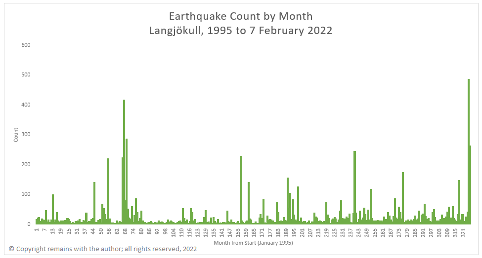
As we have extended our database of Icelandic earthquakes back to 1995, we have plotted the earthquakes for the period from 1995 to 7th February 2022 for the area 64.2°N 19.2°W to 65.3°N 21.8°W.
There is a relatively low level of background activity compared to the other volcanic regions of Iceland. However, the following months each saw more than 200 earthquakes: 55 (July 1999) near Þórisjökull and Prestahnúkur , 66 (June 2000) near Geysir, 67 (July 2000) near Geysir, 69 (September 2000) near Geysir, 155 (November 2007) near Hveravellir and Geysir, 240 (December 2014) near Geysir, 325 (January 2022) near Ok and 326 (February 2022) near Ok. Note: that February 2022 is only one week.
We noted six warms to the west of Ok, including the current swarm. They appear to be aligned along a rift / fissure. The current swarm near Ok is one of the largest in the database to date.
It’s not clear from the plots, themselves, whether or not there is any magma movement associated with the current swarm or, indeed, any of the other activity identified. The size of the current swarm indicates that something may be going on near Ok. Only time will tell if volcanic activity will ensue. In the mean time, the plots do shed some light on the activity along rifts associated with plate seperation.
Icelandic Meteorological Office: www.vedur.is for raw earthquake data
Kristján Sæmundsson (Iceland GeoSurvey) (2019). Prestahnúkur. In: Oladottir, B., Larsen, G. & Guðmundsson, M. T. Catalogue of Icelandic Volcanoes. IMO, UI and CPD-NCIP. Retrieved from http://icelandicvolcanoes.is/?volcano=PRE
Guðrún Larsen and Magnús T. Guðmundsson (Institute of Earth Sciences – Nordvulk, University of Iceland) (2016): Langjökull, Hveravellir. n: Oladottir, B., Larsen, G. & Guðmundsson, M. T. Catalogue of Icelandic Volcanoes. IMO, UI and CPD-NCIP. Retrieved from http://icelandicvolcanoes.is/?volcano=LAN
John Sinton, Karl Grönvold, Kristján Sæmundsson, “Postglacial eruptive history of the Western Volcanic Zone, Iceland”, Geochemistry, Geophysics, Geosystems, AGU, Volume 6, Issue 12, December 2005, https://doi.org/10.1029/2005GC001021
For the Pleistocene volcanoes we consulted Wikipedia and the Smithsonian Institution – Global Volcanism (www.volcano.si.edu/)
A major eruption occurred on the island of Hunga Tonga-Hunga Ha’Apai on 15th January 2022 at 04:14:45 am (UTC). As with Krakatau, news of the eruption arrived before the pressure wave from the blast due to modern technology (now the internet, then the telegraph). The eruption was preceded by a smaller one at the end of 2021 which ended 11th January 2022. Activity picked up again on 14th January 2022. Our thoughts are with all those affected.
2021 Eruption
Hunga Tonga-Hunga Ha’Apai has been erupting since 20th December 2021. The initial eruption produced a large plume (height unknown) and was heard up to 2,000 km away in New Zealand. Activity died down and the eruption was declared over on 11th January 2022.
This eruption added to the land created during the 2009 and 2014/15 eruptions which links the islands of Hunga Tonga and Hunga Ha’Apai.
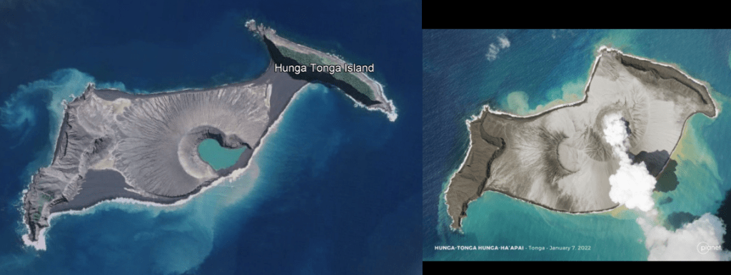
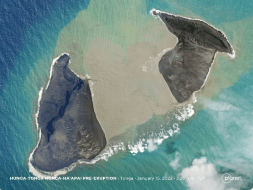
Fig 1: Hunga Tonga-Hunga Ha’Apai pre the December 2021 eruption (image from Google Earth) on the left and Hunga Tonga-Hunga Ha’Apai on January 7, 2022 on the right (image from Planet (@planet) / Twitter)
January 2022 Eruption
Activity resumed on 14th January 2022 with a 20 km high ash cloud. Geologists from Tonga reported large explosions and a 5 km wide ash column. Their report can be found here Tongan geologists observe stunning eruptions at Hunga | Matangitonga . At the time of writing this is the last update from the news source in relation to the eruption.
An image from @Planet taken, it is believed, two hours before the 15th January 2022 shows that the 14th January 2022 eruption had removed a lot of the subaerial land bridge between the two islands.
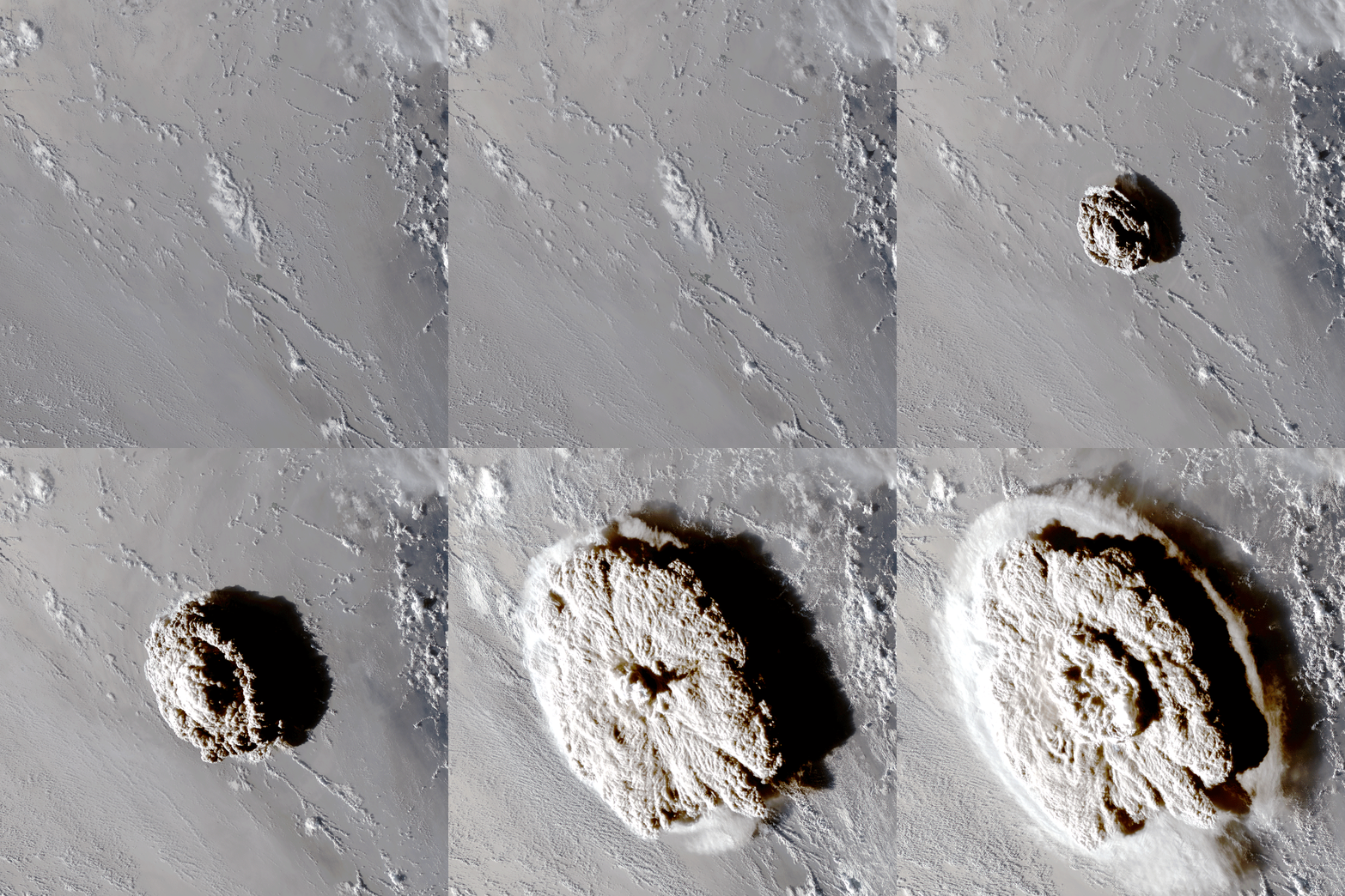
On 15th January 2022, a much larger eruption occurred which was heard as far away as Alaska and Canada. USGS estimate the surface wave magnitude as 5.8. The pressure wave has travelled round the globe: it was measured as 7hPa in New Zealand, 2.5hPa in Switzerland and 2hPa in the UK.
The eruption covered the surrounding islands in ash, blocking out the sun in Tongatapu, the main island in Tonga. Tonga lost its internet connection, probably due to damage to underwater cables so an assessment of the damage has not been possible. The Australian and New Zealand Governments have offered assistance, including over-flights to assess the damage; the flights are hindered by the ash cloud.
Known Impact
A large amount of material is thought to have been ejected into the stratosphere. This may cause temporary climate cooling in the region and possibly globally. New land linked the islands of Hunga Tonga and Hunga Ha’Apai was cut through during the activity on 14th January 2022; how much remains has not been confirmed at the time of writing, but it is expected that more of the subaerial edifice has been lost.
A Pacific-wide tsunami was generated which reached heights of 0.3m (Mexico), 1.3m (California), 2m (Chile), 2.5m (Vanuatu) and 1.5m (Tonga). Low lying islands such as Atata Island were submerged by the tsunami. Tsunami warning systems worked; the known fatalities are low. Although closer to the volcano where residents had only minutes to flee to higher ground, the toll is not known.
The cause of the tsunami is not known. It may have been due to one or more of the following: edifice failure allowing to sea water to reach the magma chamber causing a large explosion; a large volume of pyroclastic material dumped into the ocean; or, a submarine landslip. We will have to wait until the experts have had a chance to assess.
Background
Tonga is an archipelago of 169 flat low-lying coral limestone islands, some with volcanic bases, of which 36 are inhabited. It is home to 105,000 people, of which 70% live on Tongatapu. Tongatapu has a wealth of archaeological remains, including traces of Lapita pottery from the earliest known settlers, the Lapita. Tonga was also the seat of the Tongan Empire which emerged in 950 AD and declined after 1500 AD; it is now a kingdom with a constitutional monarchy. Hunga Tonga-Hunga Ha’Apai lies 65 km to the north of Tongatapu.
Hunga Tonga-Hunga Ha’Apai is two volcanic islands joined by a land bridge created during the 2009 eruption. Hunga Tonga is the island on the right of the images and Hunga Ha’Apai the one on the left. The islands are the subaerial manifestation of the caldera of a submarine volcano. Its lavas are andesitic. Five Holocene eruptions are recorded by GVP: 1912, 1937, 1988, 2009, and 2014; all were VEI 2, except for the VEI 0 1988 eruption. Other eruptions evidenced by rock and ash deposits, including evidence of pyroclastic flows, occurred in 1040 – 1180 CE and 1108 CE; the latter is believed to have formed the caldera and caused 1°C global cooling.
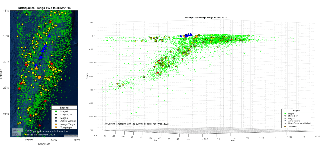
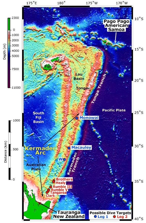
The volcano is situated 100km above the subducting Pacific Plate on the Tonga Plate in the Tonga Kermadec Volcanic Arc. The Tonga Plate is a microplate which lies between the Pacific Plate, the Niuafo’ou Plate and the Kermadec Plate.
The Tonga Kermadec Volcanic Arc lies on the 3,000 km long 100 Ma old Tonga Kermadec Ridge. The ridge has two segments: the Tonga Ridge in the north and the Kermadec Ridge in the south. There are two back arc basins to the west of the ridge: the 6 Ma old Lau Basin and 2Ma old Havre Trough, that began opening at 6 Ma and 2 Ma respectively. The Tonga Kermadec Ridge moves independently of the Indo-Australian and Pacific Plates to its west and east, resp.
Seismic activity at Fagradalsfjall, Iceland, has remained low. The recent swarm is now considered over. The aviation code has been lowered to yellow as a result.
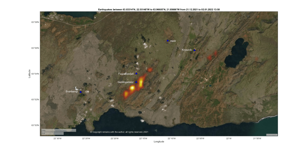
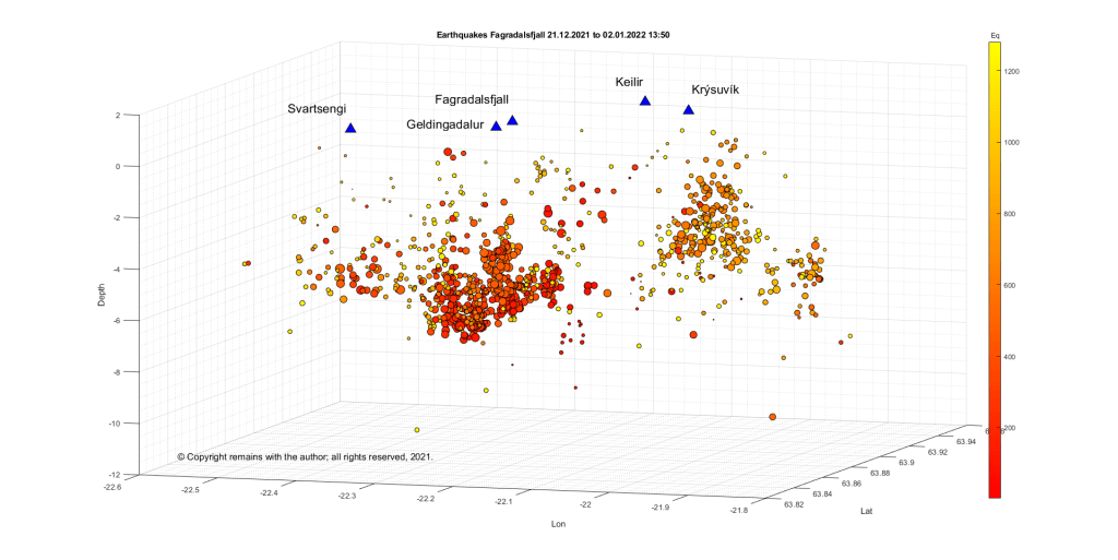
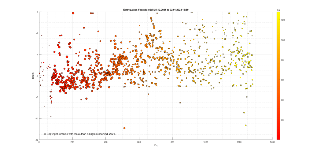
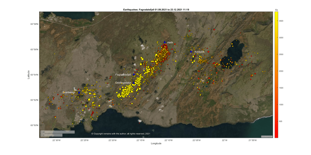
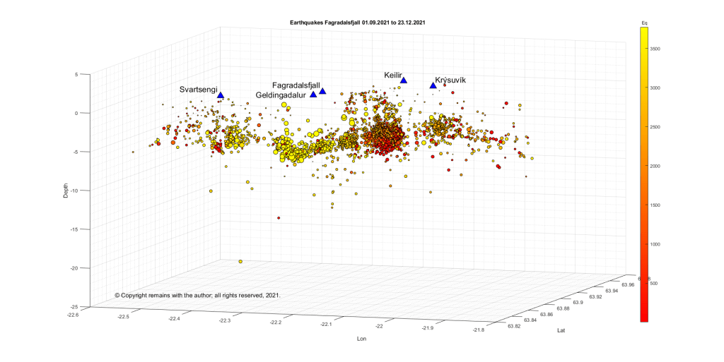
We have updated the earthquake plots for Fagradalsfjall, Iceland, for the swarm which started on 21 December 2021.
The swarm had an intense initial period while magma moved along a lateral dike, followed by a less intense period, accompanied by magma ascent. The Icelandic Met Office, IMO, say that the swarm is following the same pattern as that which preceded the eruption in March 2021.
Magma is ascending under Fagradalsfjall, itself. The outlying earthquakes, e.g., at Svartsengi and Krýsuvík, are what Iceland calls triggered earthquakes. Triggered earthquakes are tectonic in nature, arising as local faults respond to magma movement.
Following a drop in seismicity over the past couple of days, visitors are now advised to avoid the area.
A similar drop in seismicity was observed immediately before the March 2021 eruption.
If the volcano does erupt again, this would be considered a new eruption in the same place; the earlier eruption was declared over three months after the cessation of activity on 19 September 2021.
Update 28/12/2021
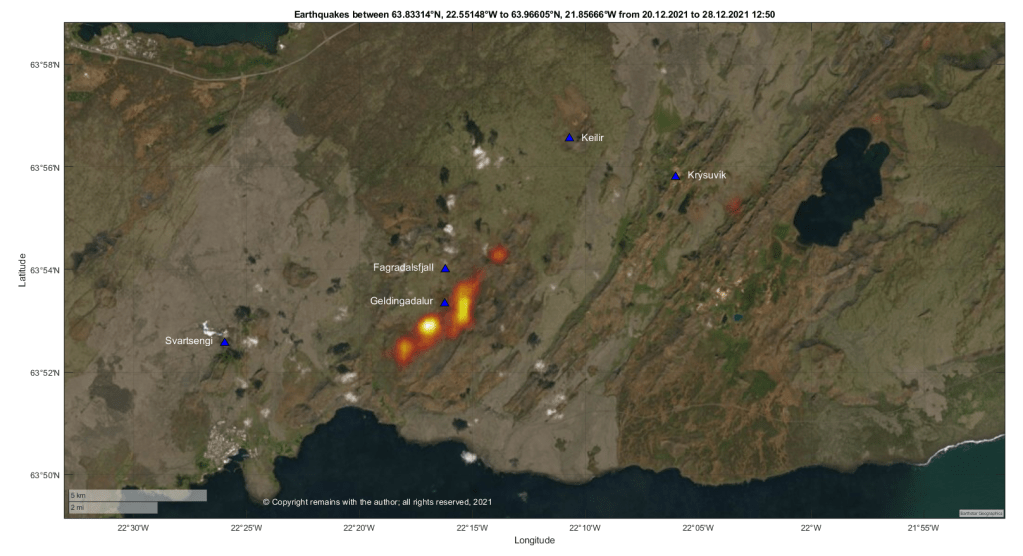
The earthquake swarm at Fagradalsfjall, Iceland, is continuing. While the swarm has slowed down a bit, 19,000 earthquakes have been recorded by the automatic SIL system since the swarm started. 14 earthquakes over 4.0 magnitude have occurred. An alert for the risk of rockfall and landslides in the area has been raised; visitors are advised to stay away from the area.
We have plotted the confirmed earthquakes from 20 December 2021 to 28 December 12:50. This shows the dike propagation south west of Geldingadalur, with additional activity near Kýsuvík and Svartsengi.
Only time will tell where and when lava will emerge. In the meantime, if you are lucky enough to be in the area, be aware of the risk of rock fall and landslip.
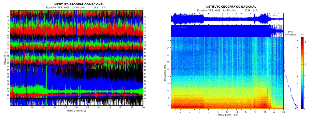
There was some good news for La Palma over the week end; the eruption was declared over on 25 December 2021. The eruption, itself, ended on 13 December 2021 at 22:21. There was a precautionary period of waiting before announcing the end of the eruption.
This is an important milestone in the process to recover and rebuild.
Fig 1: Seismic signal showing the end of the eruption. Source: IGN
Statistics
Eruption
The eruption started on 19 September 2021 as a flank eruption on the Cumbre Vieja volcano and ended on 13 December 2021. The duration of the eruption was 85 days and 8 hours – the longest for which there are historic records.
The eruptive style is described as Strombolian fissural with phreatomagmatic pulses.
The average height of the plume was 3.5km and its the maximum height was 8.5 km on 13 December 2021.
Edifice
The cone’s height is now 1,121m.
There are six craters, with diameters ranging between 106m and 172m.
Lava
200 million cubic meters erupted, covering an area of 1,219 hectares with an average thickness of 12m and maximum width of 3,350m.
The maximum temperature was 1,140°C.
Two lava deltas were created covering c. 48 hectares (one c. 43 hectares and the other 5 hectares).
Damage
2,988 buildings were destroyed and 138 damaged, according to satellite data. This is initially analysed by the local authorities as 1,345 residential properties, 180 agricultural, 75 industrial, 44 leisure, 16 public and 16 other; the shortfall is attributed to properties having more than one building within their boundaries.
Infrastructural damage includes: 73.8 km of road have been damaged along with streets and crossings; and, 130km power lines, 85 medium voltage towers, 1500 low voltage poles and 19 distribution centres.
We do not have an up to date analysis of the extent of the damage to crops and livestock.
Around 7,000 people were evacuated.
There was sadly one fatality which is under investigation.
Seismic Activity
9,135 earthquakes were recorded in the period from 11 September (the onset of the swarm) and today, 27 December 2021. Due to the severity of the volcanic tremor, many smaller quakes were not recorded.
We have plotted the sequence. The results are shown in the video below.
A large earthquake swarm started at Fagradalsfjall late on 21 December 2021, 2-4 km NE of Geldingadalir, thought to be caused by a lateral dike intrusion. Due to the increased seismic activity, the aviation code was raised to Orange yesterday, 22 December 2021.
Fig 1: Icelandic Met Office, IMO’s map of the swarm. Source: IMO
The eruption at Fagradalsfjall had stalled on 18 September 2021, with no new lava flows to the time of writing. Ground deformation indicated that magma was still flowing into the crust.
Fig 2: Ground deformation at Krýsuvík. The red line denotes the start of the March 2021 eruption. Source: IMO
We have downloaded and plotted the earthquakes from 1 September 2021 to 23 September 2021 (source for raw data: IMO ). This includes the swarm which started near Mount Kelir in late September 2021, which may or may not have heralded the current reactivation of the dike.








_julesvernex2.jpg)


.svg)