Time to check out the current status of the volcanoes we have been following, especially as the situation has changed for some.
Askja
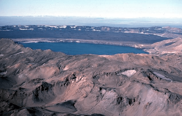
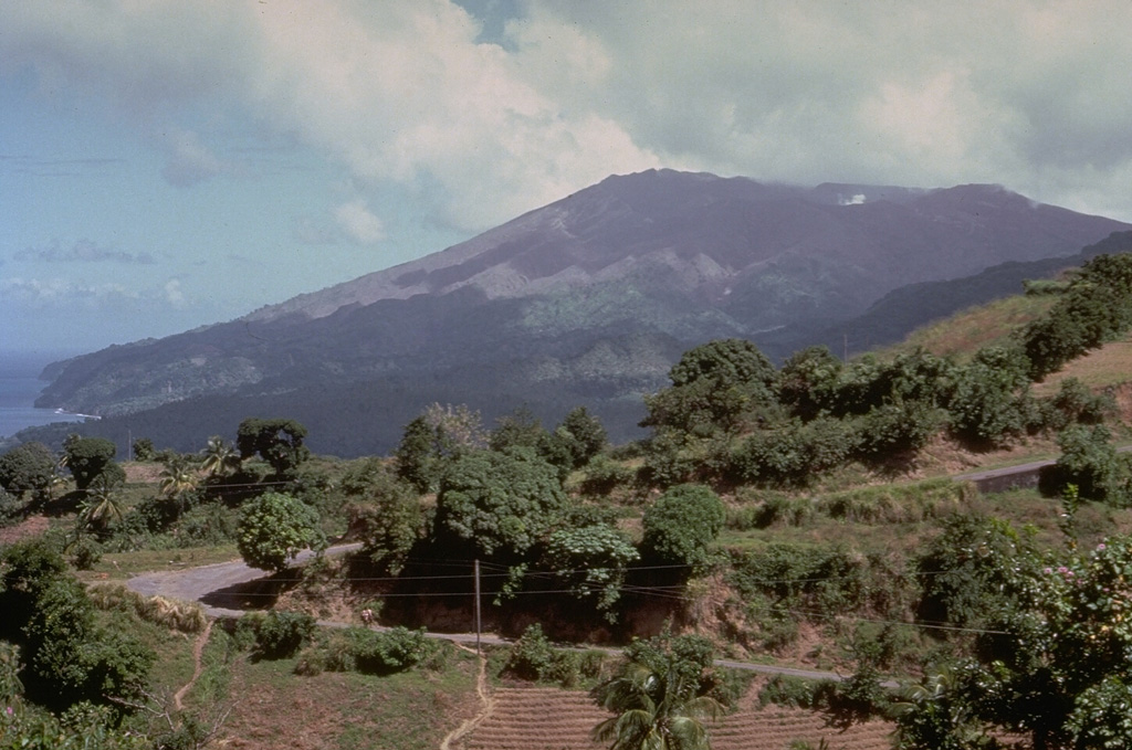
Fig 1: Image of Askja caldera by M Ryan, USGS, public domain.
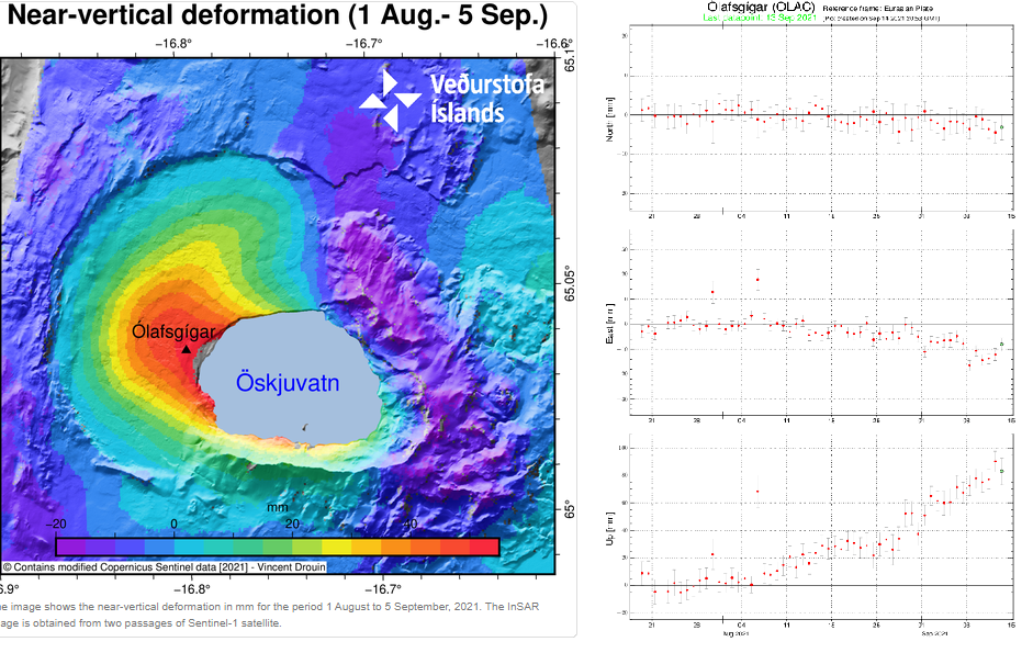
Inflation, thought to be caused by a magma intrusion at a depth of 2km-3 km, started in early August. GPS data and satellite images detected uplift of 5cm per month; the uplift centred on the western edge of the Öskjuvatn caldera.
The aviation code was raised to yellow on 9 September 2021, following near vertical uplift of 7cm.
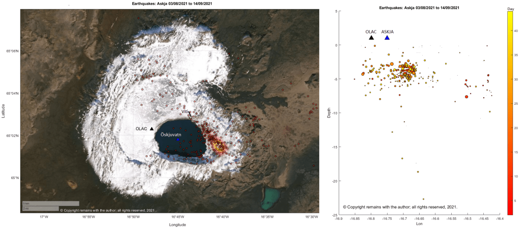
The epicentres of current earthquake swarm are mostly to the east of the Öskjuvatn caldera following a near linear route, starting at, or near, the area of maximum earthquake density for the period 1995 to 09.09.2021, and heading for the Viti explosion crater; seismic activity is on the opposite side from the area of maximum uplift.
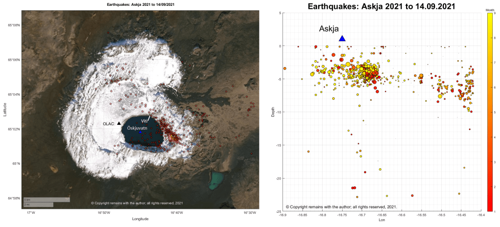
Seismicity for 2021 looks pretty similar; the current swarm follows the pattern of earlier seismicity.
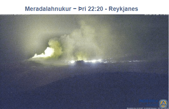
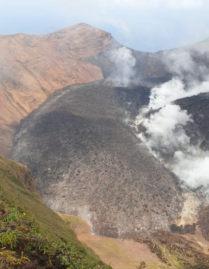
Fig 4a: Crater at Fagradalsfjall erupting on 14 September 2021.
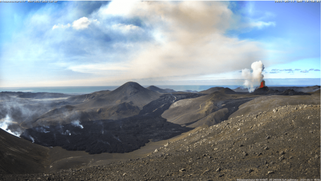
The crater at fissure 5 has grown considerably since we last posted about it; it now dominates the surround hills. The eruption paused on 2nd September 2021, taking a well-earned break; steam and gas emissions continued. The eruption resumed a couple of days ago. The aviation code remains orange.
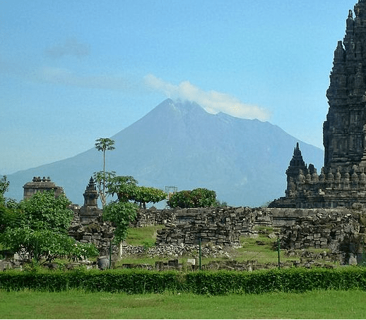
Fig 5: Merapi 2011 with Prambanan in the foreground, cropped from an image of Prambanan by Arabsalam, published under CC BY-SA 4.0. Source: Prambanan Java243. Prambanan is an 8th Century Hindu temple compound located approximately 17 kilometres (11 mi) northeast of the city of Yogyakarta and designated a UNECSO World Heritage Site.
Both lava domes situated below the south west caldera rim continue to grow, producing numerous pyroclastic flows and avalanches.
The alert level remains at thee and there is a 3km – 5km exclusion zone.
Grímsvötn
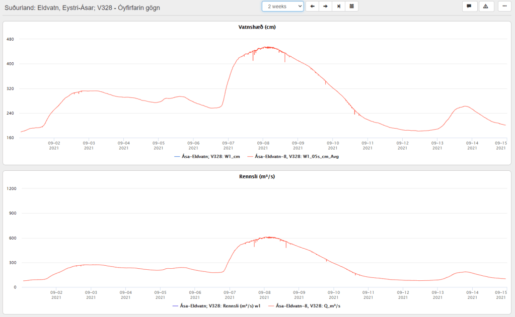
A jökulhlaup started on 1 September 2021 from the western Skaftlá caldera; the peak flow rate reached 520 m3/s on 2 September 2021. Warnings were issued of the hazard from H2S from water draining from the caldera lake. The ice-shelf had subsided 1m by 5 September 2021.
On 6 September 2021, the peak flow rate increased to 610 m3/s, thought to be due to a second release of water from the caldera lake – this time on the eastern side.
The aviation code remains at yellow.
Fig 6: Top image shows the water levels reached at Eldvatn and the lower one, flow rate. Source: IMO
La Soufrière St. Vincent
The last ash emissions were on 22 April 2021. Seismicity has since remained low. Gas and steam plumes have been observed rising from the crater.
The alert level remains at orange.
Mount Pelée
Volcano-tectonic earthquakes are still occurring in the edifice at depths between 0.2km to 1.2km. The area of discoloured, downgraded, burned and dead vegetation remains on the south west flanks.
At the end of July 2021 underwater gas emissions started between St Pierre and the Prêcheur. This will be investigated to ascertain how it links with the volcano.
The aviation code remains at yellow.
Mount Nyiragongo
The volcano is still active. A [gravitational] collapse in the crater caused and ash plume; ash reached Goma. Incandescence was seen on 26th July 2021 and a gas and ash plume emerged on 4th August 2021.
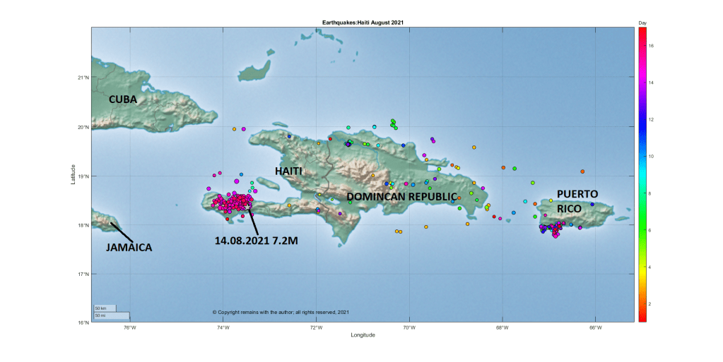
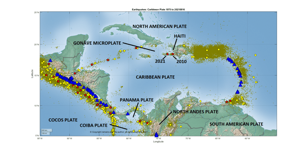
Our thoughts are with Haiti. Tragically, on 14 August 2021 at 8:29am (local time), a shallow (10km) earthquake of 7.2M occurred on the South West peninsula of Haiti 13 kilometres southeast of Petit Troup de Nippes. The earthquake was felt across the region, including Haiti, Dominican Republic, Jamaica, Cuba, and Puerto Rico. Over one million people may have been exposed to very strong or severe shaking.
A one-month state of emergency has been declared for Haiti. As of 16 August 2021, 1,419 are believed to have lost their lives, more than 6,000 injured and many thousands displaced. Tropical Depression Grace is likely to pass over the stricken area at the time of writing, bringing with it the risk of heavy rains, flooding, landslides and further loss of life.
Aftershocks are occurring, and may do so for some time. There is a small risk that this event is a foreshock to another event.
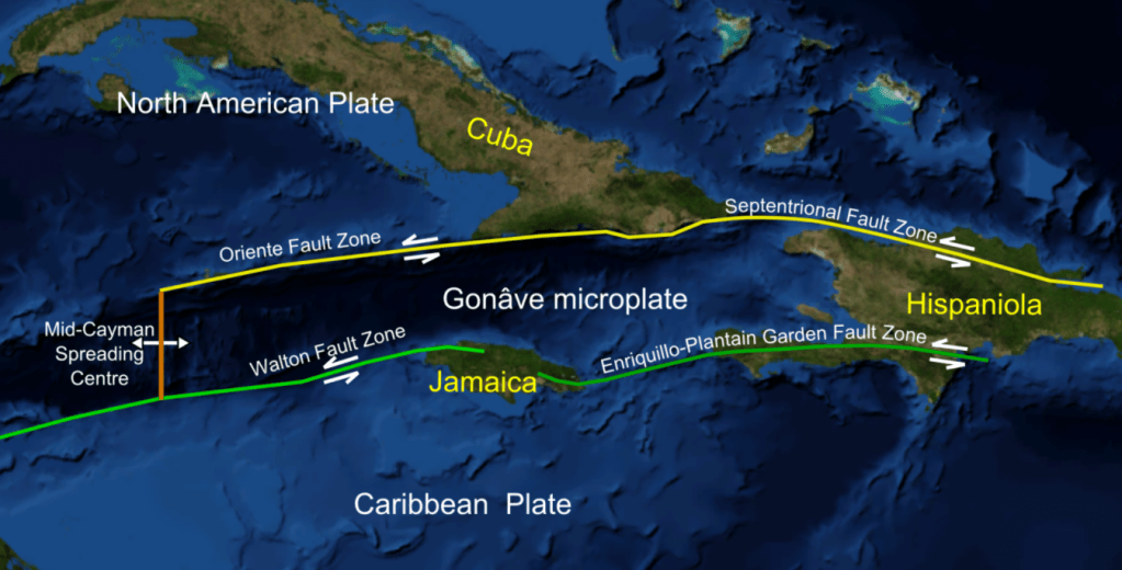
Haiti is located on the western side island of Hispaniola in the Greater Antilles Archipelago; the Dominican Republic occupies the eastern side of the island. Two large fault zones cross the island: the Septentrional-Orient fault in the north and the Enriquillo-Plantain Garden Fault Zone in the south.
Fig 2: Cropped image from one digitally altered by Mikenorton of the Gonâve Microplate (plate boundaries, main faults, islands and plates were added). Source: Gonâve microplate.
Hispaniola was formed from the collision of volcanic arcs with the North American Plate; the island is made up of 11 former island arcs. Haiti has an estimated population of 11.4 million (2018). The country is poor, politically unstable and yet to recover from the 2010 earthquake.
While the island has a volcanic past, there has not been any reported volcanic activity in the Holocene. There are two Pleistocene volcanoes in Haiti, the nepheline basalt scoria cones of Morne la Vigie, north of Port au Prince, and Thomazeau, east north east of Port-au-Prince, both of which were active around 1.5 million years ago; and, three in the Dominican Republic, the basaltic cinder cones of San Juan, trachyandesite lava domes and flows of the Dos Hermanos volcanic field and the rhyolitic to basalt Valle Nuevo volcanic field. The presence of picrite in the Duarte Complex in central Hispaniola and enriched basalts in southern Haiti are thought to be indicative of earlier hotspot activity
Tektites have been found in the Beloc Formation, Haiti, which are thought to have originated from the asteroid impact in Yucatán Peninsula, Mexico, which caused the K-Pg mass extinction event 66 million years ago.
2021 7.2 M Earthquake
The earthquake occurred in the Enriquillo-Plantain Garden Fault zone on the transform plate boundary between the Caribbean Plate and the North American Plate. The faulting mechanism for this earthquake indicates oblique thrust faulting along the fault zone. This fault zone accommodates 7mm per year of the 20mm per year of the relative plate motion. It is likely that this earthquake occurred in the same fault system as the devastating January 2010 7.0M earthquake which occurred near Port-au-Prince, the capital.
According to the DEC, the January 2010 earthquake not only caused significant loss of life and damage but also severally impacted Haiti’s government and infrastructure: 25% civil servants died, 60% government buildings, 80% schools in Port-au-Prince and 60% schools in the South and West departments were destroyed. In all, over 220,000 were killed, more than 300,000 injured and around 300,000 homes damaged or destroyed.
USGS note that four other large earthquakes are known to have occurred in the region: October 1751 in the Gulf of Azua at the eastern end of the Enriquillo-Plantain Garden fault zone; November 1751 at Plaine du Cul-de-Sac which destroyed Port-au-Prince; June 1770 which also destroyed Port-au-Prince; and, April 1860 which also caused a tsunami.
It is expected that there will be a request for international aid. If you wish to help / donate to the aid effort, refer to your favourite international aid agency, in the first instance.
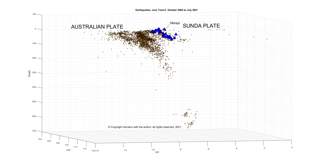
Today we are taking a trip to Java, Indonesia, away from the gentle effusive eruption at Fagradalsfjall, Iceland, and what looks like the growth of a shield volcano, to the more explosive activity at the subduction zone between the Indo-Australian Plate and the Sunda Plate, focussing on Gunung Merapi.
Merapi has been erupting since the start of the year, with the growth of two lava domes, block and ash falls and pyroclastic flows generated from partial collapses of the lave domes. The current alert level is 3 (Siaga) and the aviation code is orange. (Siaga translates as, using Google Translate, “Stand By” (There was a significant increase in volcanic activity. Eruption is most likely to occur and the area of potential eruption hazard is in the area of Disaster-Prone Areas (KRB) II. The community is prohibited from carrying out activities in the KRB II area). The exclusion zone extends 5km from the summit).
Fig 1: Merapi 2011 with Prambanan in the foreground, cropped from an image of Prambanan by Arabsalam, published under CC BY-SA 4.0. Source: Prambanan Java243. Prambanan is an 8th Century Hindu temple compound located approximately 17 kilometres (11 mi) northeast of the city of Yogyakarta and designated a UNECSO World Heritage Site.
Background
Merapi is a 2,968 m high stratovolcano located 25 km north of the city of Yogyakarta on the island of Java, Indonesia. Volcanic activity at Merapi is believed to have started around 170,000 years ago. Since then, activity alternated between effusive and explosive, the latter with lava domes and pyroclastic flows. While her eruptions are comparatively modest (VEI 1 to 4), her proximity to a large metropolis means she has the potential to do a lot of damage, hence her status as a Decade Volcano. Over 4 million people live within 30 km of the volcano and over 24 million people live within 100 km of the volcano.
Yogyakarta, itself, is a densely populated city in the Special Region of Yogyakarta. 373,589 people live in the city (Census 2020) and over 4 million in the metropolitan area. It is a sophisticated centre for Javanese fine arts, culture and education. Yogyakarta has been home to the seat of power for the Medang Kingdom between the 8th and 10th century and Mataram Sultanate between 1587 and 1755. Explosive eruptions from Merapi, which destroyed many Buddhist and Hindu temples built between 732 AD and 900 AD (and presumably caused other significant damage), may have been a factor in the migration of the Mataram Kingdom to East Java in 928 AD or 929 AD.
Tectonic Setting
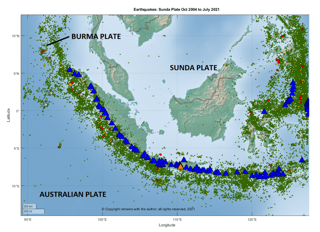
Volcanic activity on Java is driven by the northward subduction of the Australian Plate under the Sunda Plate at the Sunda Trench. The western, southern and eastern boundaries of the Sunda Plate are tectonically very active.
We downloaded earthquake data from EMSC for the period October 2004 to July 2021 between 14.04°S 86.16°E to 12.66°N 127.48°E to take a look. This area is larger than the area under discussion to make sure that subduction zone was captured. The following images are from extracts of that data.
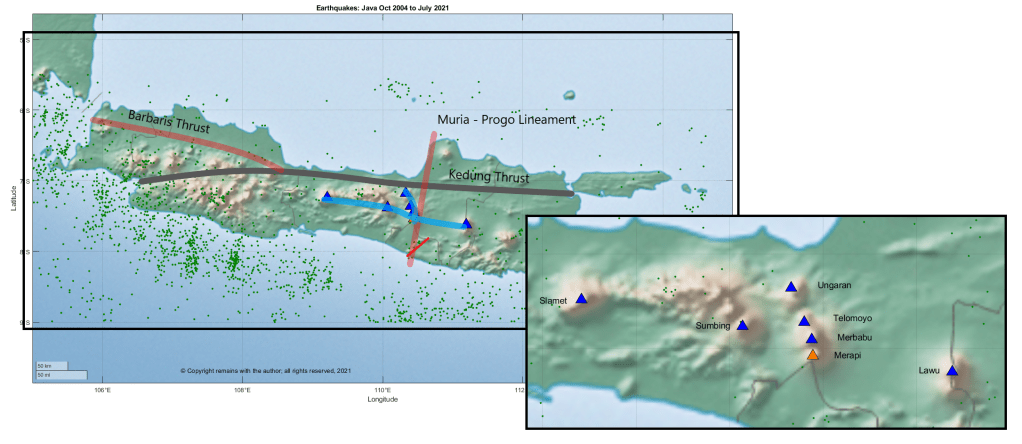
Merapi is located at the intersection of two volcanic lineaments: the north – south trending Ungaran-Telomoyo-Merbabu-Merapi; and the east – west trending Lawu – Merapi – Sumbing – Sindoro – Slamet. Ungaran-Telomoyo-Merbabu-Merapi is a double chain volcanic arc, with Ungaran as the back arc and Telomoyo-Merbabu-Merapi as the trench side volcanoes. Merapi is also bounded by two faults: the north – south Merapi – Merbabu fault and the Baribis – Semarang – Kendeng fault.
Merapi formed in the late Pleistocene and Holocene in three stages: Proto-Merapi, Old Merapi and New Merapi.
Proto-Merapi emerged after 170 ka and includes Gunung Bibi, dated to 190 ± 60 ka, Gunung Turgo, 138 ± 3 ka, and Gunung Plawangan ,135 ± 3 ka.
Gunung Plawangan was home to a volcano observatory until the 1990s but was abandoned due to nuée ardentes from the current cone.
The summit of Gunung Turgo is home to sacred graves including that of Sheikh Jumadil Qubro, a direct descendant of the Islamic prophet, Muhammad.
Old Merapi started to grow around 30 ka, reaching a height slightly more than the current cone; growth ended with flank failures 4.8 ± 1.5 ka. Collapse of the caldera with debris avalanche flows to the south and west left a Somma rim on the eastern slope.
Gunung Batulawang and Gunung Kendil are part of Somma – Merapi. Gunung Batulawang is the highest peak of Old Merapi. Lake Borobudur formed c 3,400 14C years BP.
The latest Somma collapse was around 1,900 14C years BP.
New Merapi, the current cone, grew soon after the growth of Old Merapi ended. Partial edifice collapse of New Merapi may have occurred 1,130 ± 50 14C years BP.
Gunung Selokopo Ngisor, Gunung Pusunglondon, Gunung Patukalapalap, Gunung Dengkeng, Gungung Selokopo Duwur and Gunung Gadjah Mungkur are hills which are thought to belong to New Merapi.
Volcanic Activity
Merapi’s lavas are typical for a subduction zone, being andesite / basaltic andesite, trachyandesite, basaltic trachyandesite with some basalt / picro basalt and trachybasalt / tephrite basanite. Her lavas have evolved over time. Her early lavas were effusive basaltic. The K2O content of the lava has increased over time; Old Merapi had lower K2O lavas than New Merapi and nearby Gunung Telomoyo and Gunung Merbabu.
According to GVP, there have been 111 Holocene eruptions, ranging from VEI 1 to 4. The most recent eruption, currently a VEI 1, started on 31 December 2020, with new lava domes extruded in January and February 2021, and, at the time of writing is ongoing. The most recent VEI 4 was the devastating October 2010 to July 2012 eruption in which partial dome collapse caused pyroclastic flows that destroyed villages, led to the evacuation of more than 300,000 people and caused 386 fatalities; the ash plume reached 18km between 4-6 November; and, the largest pyroclastic flows occurred on 26 October 2010 and 5 November 2010 – the latter produced the widest pyroclastic flow seen in Indonesia for 100 years. By mid-November, eruptive activity subsided, to be followed by lahars as the main hazard.
The 26 October eruption started 19 hours after tsunamis caused by earthquakes on the Sunda Trench swept away villages on the Mentawai Islands, killing 428 people and displacing thousands. The earthquakes were a 7.7 M, preceded by a 5.8 M and followed by aftershocks that included a 6.1 M and 6.2 M. Whether or not the earthquakes triggered the eruption, itself, is open to debate; the volcano was ready to erupt. Since 2007 swarms of volcanic earthquakes had been occurring; deformation and gas emissions increased in September 2010; and, seismicity increased between 15 – 26 October, ramping up during 20 – 26 October. The alert levels were raised to level 2 on 20 September 2010, level 3 on 21 October 2020 and level 4 on 25 October 2020.
A phreatic eruption on 11 May 2018, heralded a new phase of lava dome growth. In November 2020, evacuations were ordered due to decreasing stability of the lava dome. Eruptions commenced on 4 January 2021, leading to further evacuations in the Yogyakarta region.
Here’s hoping the current eruption remains a VEI 1.
The Smithsonian Institution’s Global Volcanism Program (GVP): Merapi
Ralf Gertisser, Silvain J. Charbonnier, Jörg Keller, Xavier Quidelleur, “The geological evolution of Merapi volcano, Central Java, Indonesia”, Bulletin of Volcanology (2012) 74: 1213=1233. DOI: 10.1007/s00445-012-0591-3
Newhall, C. G., Bronto, S., Alloway, B., Banks, N. G., Bahar, I., del Marmol, M. A., Hadisantono, R. D., Holcomb, R. T., McGeehin, J., Miksic, J. N., Rubin, M., Sayudi, S. D., Sukhyar, R., Andreastuti, S., Tilling, R. I., Torley, R., Trimble, D., Wirakusumah, A. D., “10,000 Years of explosive eruptions of Merapi Volcano, Central Java: archaeological and modern implications”, Journal of Volcanology and Geothermal Research 100 (2000) 9 – 50. DOI:10.1016/S0377-0273(00)00132-3
The recent eruption Mount Nyiragongo has taken us away from Iceland and the ongoing eruption at Geldingadalur, Fagradalsfjall, Iceland, to look at the East African Rift System. Unlike the current benign eruption in Iceland, there are 32 known fatalities from Mount Nyiragongo’s eruption, 3,629 homes and buildings destroyed, more than 20,000 displaced, many unaccounted for and several hundred thousand evacuated from parts of Goma to Sake. The current alert status for the volcano is orange. Our thoughts are with all those affected by the eruption.
As we refer to different lavas in more detail than originally anticipated, we will explain them in future posts; please bear with us for the moment.
Fig 1: Photo of Mount Nyiragongo by B. Martinelli, 1994 (courtesy of Jack Lockwood, U.S. Geological Survey) (left) and screenshot of the Nyiragongo crater with lava lake pre 2021 eruption from Google Maps (right).
It has been reported that the volcano had not been fully monitored for several months due to lack of funding for the Goma Volcano Observatory. Monitoring improved in May 2021 when an American partner helped to get the internet connection to seismometers restored. This, and the ensuing eruption, must have been worrying times for the Observatory.
2021 Eruption
Run Up to the 2021 Eruption
Reports on GVP for Mount Nyiragongo note that strong thermal anomalies and gas emissions were observed in the period June 2018 to May 2020, along with incandescence, seismicity and gas / steam plumes.
In the period from June 2020 to November 2020, daily thermal activity was observed, indicating the presence of a large lava lake; levels of SO2 emissions fluctuated during the period.
Eruption May 2021
Mount Nyiragongo erupted on 22 May 2021 at around 18:15 local time, sending torrents of low viscosity lava down the side of the volcano, reaching as far as the outskirts of Goma. The following account of the eruption is summarised from bulletins on GVP.
The crater lava lake drained followed by the opening of at least two fissures on the south flank of the volcano. The first fissure’s lava originated near the Shaheru crater flowing eastwards over a main road; lava flows from the second fissure reached villages north of Goma destroying around 3,629 homes and buildings, displacing 20,000 to 25,000 people, and cutting off electricity and water supplies to parts of the city. Ash plumes, caused by collapse in the summit crater, rose initially to 45,000 feet then 20,000 to 30,000 feet.
Eye witnesses report that no felt earthquake preceded this eruption, which is consistent with instrument monitoring. Between 22 and 24 May 2021 earthquakes occurred between the summit and Lake Kivu. Tremors were felt in Goma every 30 minutes from midday 23 May 2021. Cracks appeared in different parts of the city, stretching several hundred metres southwards to the lake, some emitting gases and flames. A 5.1 M earthquake occurred beneath Lake Kivu at 10:37 on 24 May 2021. Seismicity remained intense on 25 May with more than 130 earthquakes between 2M and 5M recorded in a 24-hour period. News reports indicated hundreds of damaged buildings in neighbouring Rwanda. Rwanda suffered 13 earthquakes in excess of 4.0 between 23 May to 27 May 2021. Seismicity has since decreased, although there is some evidence suggesting magma movement beneath the city of Goma.
The volcano is monitored by the Observatoire Volcanologique de Goma (OVG). OVG have given four possible scenarios as to how the eruption could progress:
A new fissure eruption on the southern flanks of the volcano;
A new eruption with fissures in or extending to the cities.
A new eruption with fissures extending to Lake Kivu.
Activity subsides.
Lake Kivu contains dissolved gases, including CO2. Heat or other disturbance from fissure activity beneath the lake may release dissolved CO2 in a cloud that could kill at lower elevations in its path. Although the 2002 eruption did not cause a large gas release from the lake, you can never say never.
Background
Tectonic Setting
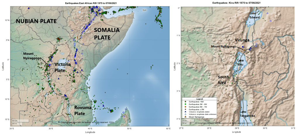
Nyiragongo is 3,470 m high stratovolcano with a 1.2 km wide summit crater which contained a small active cone and lava lake, located in the Virunga Mountains in the Kivu Rift on the western arm of the East African Rift. The volcano’s edifice is built of lava flows and pyroclastics. Goma, with a population of 670,000 is located on the shores of Lake Kivu 12 km south of the volcano.
Volcanic and tectonic activity in the area is complex, influenced by to the opening of the East African Rift System in the midst of pre-existing areas of crustal weakness. The East African Rift System is a 3,000 km long continental rift extending from the Afar Triple Junction to western Mozambique. The Nubian Plate is moving away from the Arabian and Somalia Plates. Mantle plumes are thought to be the cause of doming and rifting. Rifting occurs at rates of 1 to 4mm a year, increasing north to south on the western arm of the rift and increasing south to north on the eastern arm. The slower rate of rifting in the continental lithosphere results in different volcanism than oceanic crust settings.
The Kivu Rift was created c. 5 Ma; it extends between Lake Tanganyika to Lake Albert in the central part of the western branch of the East African Rift System in an area of uplift called the Kivu Dome. There are two areas of volcanism associated with the rift, the South Kivu Volcanic Province and the Virunga Volcanic Province. Lake Kivu, itself, is a complex series of basins, the result of a rift depression whose waters drained northward until blocked by volcanic activity in the Virunga Volcanic Province c. 11,000 years ago, after which they flowed southwards. We will focus on the Virunga volcanism.
The Virunga Mountains comprise eight volcanoes on the border between the Democratic Republic of the Congo, Rwanda and Uganda. The volcanoes are: Mount Karisimbi, a 4,507m a complex basanitic-to-trachytic volcano , last known eruption 8050 BC; Mount Mikeno, a dormant 4,437m volcano; Mount Muhabura, 4,127m basanitic-to-trachyandesitic stratovolcano; Mount Bisoke, a 3,711m trachyandesitic stratovolcano, last eruption1957 ; Mount Sabyinyo, an extinct 3,674m volcano and the oldest in the range; Mount Gahinga, an extinct 3,474m volcano; Mount Nyiragongo, a 3,470m foidite stratovolcano, last eruption 2021 ; and Mount Nyamuragira, a 3,058m high-potassium basaltic shield volcano, last eruption 2021.
In the Virunga Volcanic Province, volcanic activity occurred in two stages: 1) pre-rift doming which produced alkali basalts in west Virunga c. 13 Ma to 9 Ma, after which volcanic activity ceased; and, 2) the opening of a trans extensional fault zone with ENE-WSW displacement c. 2.6 Ma.
Mount Nyiragongo’s Lavas
The Virunga Volcanic Province lavas are leucite basanite (e.g., Nyamuragira) from primitive mantle at depths of between 80km to 150km, or a more enriched leucite-melilite nephelinite (e.g., Nyiragongo) from mantle source at the same depth which has been enriched by contact with a carbonatite source. The source for the carbonatite is thought to be either from contact between rising magma and carbonate containing fluids or melt addition before or during magma generation 500 ma to 800 ma.
Nyiragongo’s melilite leucite nephelinite lavas are classed as foidite with minor basalt / picro basalt. It is the low silica foidites that make her lava’s so fluid, despite the volcano being a stratovolcano. These lavas can reach a speed of 60 – 100 km per hour and, unlike most lavas, cannot be outrun. The edifice, itself, is built of lava flows interspersed with pyroclastics.
Mount Nyiragongo’s Historic Eruptions
Recording of Nyiragongo’s eruptions started in 1884. GVP records 20 Holocene eruptions, all of which are VEI 1, except for the VEI 2 January 2002 eruption. The most recent eruptions were in 1977, 1994, 2002 and now 2021.
In 1991, Mount Nyiragongo was designated a Decade Volcano, worthy of study.
1977 Eruption
On January 10, 1977, a system of N-S fissures opened near the Baruta and Shaheru craters and the lava lake drained. Initial lava flows reached speeds of 100 km per hour due to the altitude of the fissures between 1,500m and 2,000m, combined with the low viscosity of the lava. The lava flow reached 20 km from the fissures. 600 people were killed. A herd of elephants unfortunate enough to be caught up in the flow were preserved as lava formed moulds.
2002 Eruptions
Run Up to the 2002 Eruption
The 2002 eruption was preceded by seismic and fumarolic activity enabling warning to be given and the 400,000 residents in the hazard zone to be evacuated. Initial long period events and volcanic tremors were recorded between December 2000 and January 2002. Mount Nyamuragira erupted in February 2001 for two weeks but the seismicity remained high. In October 2001, seismic activity increased and a tectonic earthquake between 3.5M and 4M was felt, followed by a high amplitude volcanic tremor. White plumes were observed in the Shaheru and central craters and a dark plume was visible from the spatter cone accompanied by new fumarolic activity. In January 2002, seismic activity increased again, along with a >4M earthquake and the resumption of fumarolic activity; an eight-hour lull in seismic activity preceded the onset of the eruption.
Eruption January 2002
On 17 January 2002, a 13 km fissure system opened on the south side of the volcano which reached Lake Kivu; lava reached Goma, itself, covering part of the local airport’s runway and reaching the lake. Again, the initial speed of the lava was high at altitude but much lower in the vents nearer to Goma (0.1 to 1km per hour). Lava erupted from the higher parts of the fissure is thought to have temperatures of c.1370°C with little or no crystal content, whereas that closer to Goma was thought to have cooled to 1,320°C causing some crystallisation and increasing its viscosity. Lava covered 4.7 km2, leaving 120,000 people homeless. 245 fatalities were caused by CO2 and buildings collapsing from lava and seismic activity. A three-month seismic swarm which followed caused more building damaged.
Six months after the first eruption the volcano erupted again in 2002.
A. Pouclet, H. Bellon, K. Bram, “The Cenozoic volcanism in the Kivu rift: Assessment of the tectonic setting, geochemistry, and geochronology of the volcanic activity in the South-Kivu and Virunga regions”, Journal of African Earth Sciences, 121, (2016), 219-246: https://www.sciencedirect.com/
R. Gill, “Igneous Rocks and Processes A Practical Guide”, Wiley-Blackwell, 2010
P. Francis, C. Oppenheimer, “Volcanoes”, Second Edition, Oxford University Press, 2004
R. V. Fisher, G. Heiken, J. B. Hulen, “Volcanoes Crucibles of Change”, Princeton University Press, 1997
At the time of writing the eruption at Fagradalsfjall is not only continuing unabated but getting stronger. After the opening of five new fissures, eruptive activity has focused on one crater, fissure 5. Lava now covers the Geldingadalur valley floor and threatens to engulf the first cones; lava has been flowing steadily into Meradalir since 24 April 2021.
Eruptive activity changed from continuous fountaining with effusive lava flows to periodic jetting after midnight on 2 May 2021. The change is thought to be due to degassing of the magma in the upper part of the eruption channel where a small chamber may have formed. Each jet is now accompanied by strong gas emissions. Lava flow, itself, is mostly being carried in lava channels under the crater rim, rather than ejected in the current jets so periodic jetting has not adversely impacted the output.
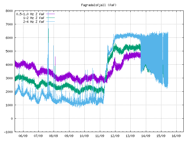
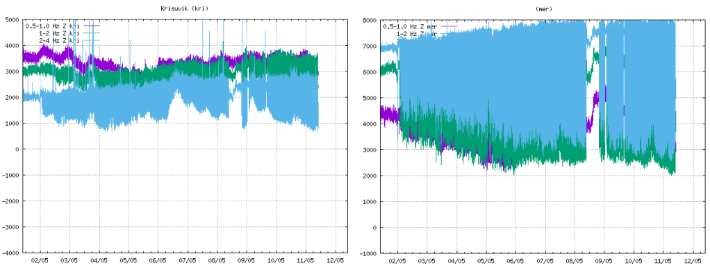
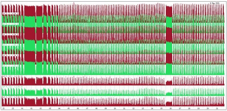
The onset of jetting can be seen in the tremor plots from local stations. We have included KRI because, being further away, we can see more of the lower frequency lines.
Fig 2: Tremor plots for KRI and MER showing the onset of jetting on 02 May 2021. Source: IMO
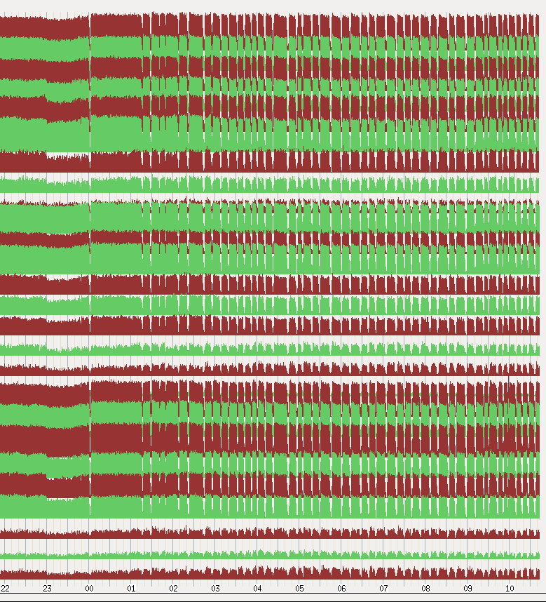
Fig 3: Unrest seen on seismometers near the eruption sites with pulses in volcanic activity from midnight on 2 May 2021. Source: IMO
Fig 4: This image shows the unrest on days 8-9. May. Source: IMO
Area of the Geldingadalsgos lava field: 1.78 Km2 (1.41Km2, 03 May 2021)
Volume of erupted lava: 30.7 million m3 (23.0 million m3, 03 May 2021)
Lava discharge rate: 12.9m3/s, (7.5m3/s, 03 May 2021)
Mg0: varies from 8.5 to 9.8
K20/Ti202 ratio: increasing from 0.1 to 0.3
In the first two weeks of the eruption lava flow decreased steadily from 7-8m3/s to 4-5m3/s. In the second two weeks, five new fissures opened with lava flow varying between 5 – 8m3/s. In the two weeks to 3 May 2021, one crater dominated with lava flow increasing. In the week to 10 May 2021, there has been a large increase in the output of lava to 12.9m3/s; the lava field now covers an area of 1.78km2 with a volume of 30.7 million m3. It is thought that the increase in output reflects changes in the lava channel from the mantle to the surface; it has widened over time.
Changes in chemical composition may mean that materials are mixing in the upper mantle before ascent or there is less partial mantle melt in the magma. If the latter, the eruption will end when the mantle source is sufficiently reduced.
Geldingadalsgos is still a toddler compared to Holuhraun; Geldingadalsgos’ eruption rate is 5% – 10% of the average eruption rate at Holuhraun between September 2014 and February 2015. Let’s hope it stays that way as it is a lot closer to residential areas.
La Soufrière St. Vincent
The alert status was lowered to orange after a period of relative quiescence on 6 May 2021; only a few long period events and volcano-tectonic earthquakes are occurring each day. People are allowed back into the orange zone but the red zone remains an exclusion zone.
The last explosive event was on 22 April 2021. However, a possible lava spine was spotted on photos on 27 April 2021. Tephra fills the crater, increasing the risk of pyroclastic flows should eruptive activity pick up again. In the meantime, lahars are the main hazard.
Mount Pelée
Mount Pelée remains on alert level yellow. Volcano tectonic events are occurring and seismic activity remains at above baseline level. An area of brown and dead vegetation was confirmed on 8 February 2021 caused by diffuse CO2 emissions; the vegetation has not recovered. The volcano is slowly reawakening.
As the new volcano at Geldingadalur continues to grow, opening and closing new fissures, we have returned to our tour of Iceland. We have now reached the Northern Volcanic Zone, where the plate boundary heads northwards from Kverkfjöll to meet the Tjörnes Fracture Zone. Active volcanoes in the zone are Kverkfjöll, Askja, Fremrinámur, Heiðarsporðar, Krafla and Þeistareykir; Herðubreið, itself, is Pleistocene palagonite table-mountain.
We are starting with the currently most seismically active volcanoes, Askja and Herðubreið, located where the Eastern Volcanic Zone meets the Northern Volcanic Zone, north of the Vatnajökull ice-cap. The mantle plume, itself, is thought to be located to the north west of the Vatnajökull ice-cap.
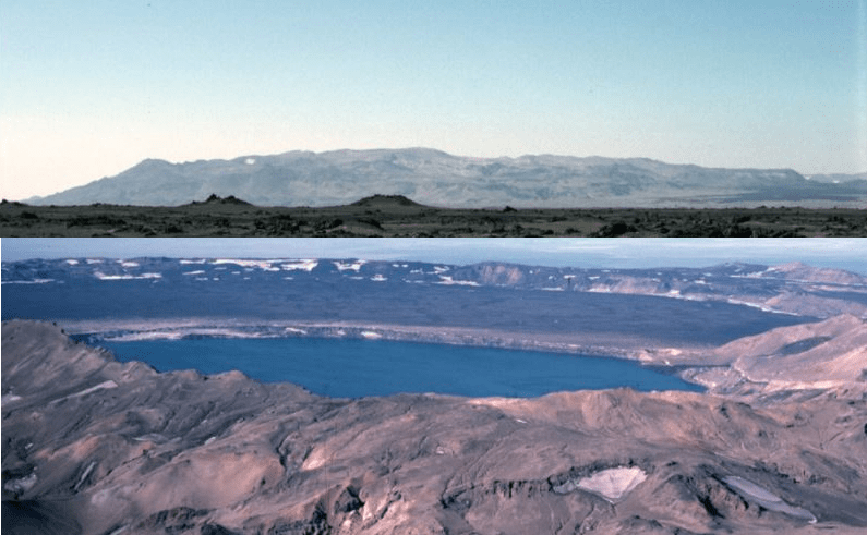
Askja
Fig 1: Combined images of Askja, cropped from photos by Michael Ryan, 1984 (U.S. Geological Survey): Askja Shield (top) and Askja Caldera (bottom) from GVP
The Askja volcanic system comprises a 1,516 m high central volcano and 190 km long fissure system, the central volcano being the Dyngjufjöll massif. It has three nested calderas, the latest of which formed in a rhyolitic eruption in 1875. The central volcano, itself, is made up of Pleistocene glacio-volcanic tuffs, hyaloclastites, pillow basalts and intercalated sub aerial lava and capped by Holocene sub aerial lavas and pumice. The fissure system, itself, extends from beneath the Vatnajokull ice-cap to the north coast of Iceland and includes small shield volcanoes.
This volcanic system does not erupt frequently; GVP records 14 Holocene eruptions which range from VEI 0 to VEI 5, the VEI 5s occurred in c. 8910 BC and 1875. Askja’s lava types are tholeiitic basalt / picro-basalt and rhyolite. Her main eruption types are effusive basalt with occasion explosive basalt or rhyolite. The 1875 eruption created a 4.5-km-wide caldera which is now filled by Öskjuvatn lake. The most recent eruption in 1961 was a VEI 2 effusive basalt one.
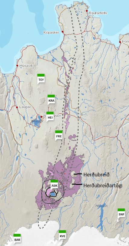
Fig 2: The Askja volcanic system from Icelandic Volcanoes . The boundary of the fissure system is delineated with a dotted line, the central volcano with a black line and the calderas with bold lines. The three letter abbreviations are other volcanic systems in the area: BAR is Barðarbunga, KVE is Kverkfjöll, SNF is Snæfell, ASK is Askja, FRE is Fremrinámur, HEI is Heiðarsporðar, KRA is Krafla and TEY is Þeistareykir. The author has added the names Herðubreið and Herðubreiðartögl.
The Askja Fires, 1874 to 1929
Askja was little known before the Askja Fires. The area is sparsely inhabited, sited in lava fields and ash deserts. The Fires occurred during a volcano-tectonic episode between 1874 to 1929.
A steam column rising from the central volcano in February 1874 was the first observed sign that the volcano was active. Northern Iceland was rocked by many large earthquakes in December 1874. Steam and ash were seen in early January 1875 and light ashfall was noted south of Öxarfjörður. By 15 February 1875, 10m subsidence had occurred in the main caldera along with the formation of a crater erupting mud. A basalt lava flow at Holuhraun to the south of Askja occurred around this time.
On 18 February 1875, a fissure eruption started on the Sveinagjá fissure north of the volcano; this generated 0.2 to 0.3km3 of basaltic lava over the course of several months.
On 29 March 1975, the Plinian eruption at the central volcano started in earnest. The initial output was a wet and sticky tephra. Shortly after 05:30, pumice was erupted, reaching as far as Scandinavia; this phase lasted until the following day. The Víti crater was formed later in a short hydro-magmatic episode. The caldera, itself, formed over a period of 40 to 50 years, is now filled by Öskjuvatn lake. As the volume of the new caldera is greater than the calculated erupted volume of lava and ash, it is thought that the excess lava is stored in the fissure system.
In 1929 to 1930, five eruptions occurred on ring faults around the Öskjuvatn caldera, with a 6 km long fissure eruption occurring on the southern side of the volcano that created the Þorvaldsraun lava.
The 1875 eruption is not the first time Askja has erupted rhyolite. Two other instances have been occurred: the c.10ka Skolli eruption and one around 2.1ka; these deposited thick layers of tephra and ash from the latter reached as far afield as Scotland and Sweden.
Holuhraun, which should be familiar to those interested in volcanology, is the area where a fissure eruption occurred in 2014. This time the central volcano responsible was Barðarbunga. At the time there was some concern at the time that the activity in Holuhruan would extend to Askja, triggering a rhyolitic eruption. Fortunately, that did not happen.
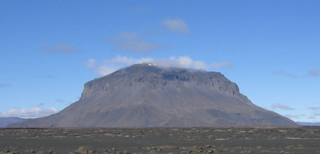
Herðubreið
Fig 3: Image of Herðubreið, cropped from a photo by Icemuon, published under CC BY-SA 3.0
Herðubreið is a 1,682m high Pleistocene palagonite table-mountain (tuya) made up of pillow lavas, hyaloclastite, capped by a 300m thick lava shield. Herðubreiðartögl, a small ridge extending from the south of Herðubreið, may be part of the same system. Although Herðubreið is close to the Askja and Kverkfjöll volcanic systems, in the absence of any post glacial activity it not known if it belongs to either system. We are including the volcano here as it is difficult to allocate the seismic activity in the area to each volcano without more local knowledge.
Herðubreið has been studied as an indicator of climate change during the last glacial periods. Werner et al, (1996) proposed that Herðubreið developed in stages from initial sub-aerial, sub-aqueous, subglacial to sub-aerial. The first sub-aerial activity occurred during an interglacial, creating an olivine tholeiitic shield volcano in the vicinity of Herðubreiðartögl. A lull in volcanic activity coincided with the onset of the last ice-age. Activity resumed with the deposition of olivine tholeiites, followed by hyaloclastites in a lake environment until the volcano breached the lake surface to produce subaerial lavas. The tuya, itself, was formed during the last glacial maximum when the volcano erupted pillow lavas under hyaloclastite deposits in the ice-cap; these were later topped by subaerial lavas when the volcano broke through the ice-sheet. At the end of the last ice-age, activity at Herðubreið had ceased, however, Herðubreiðartögl produced some later olivine tholeittic lava flows and ash deposits.
Recent Seismicity
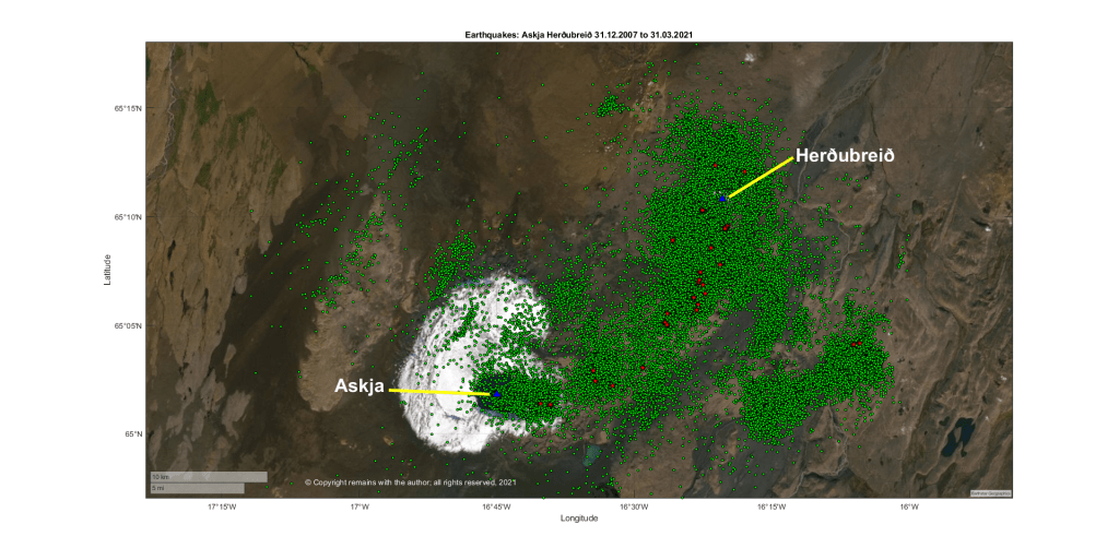
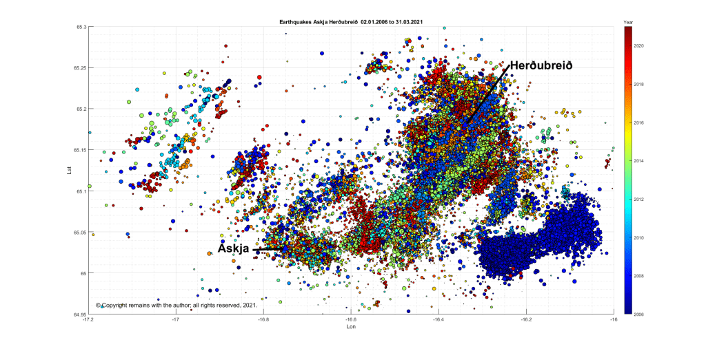
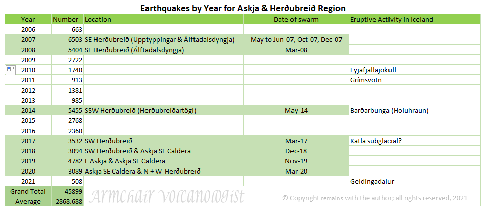
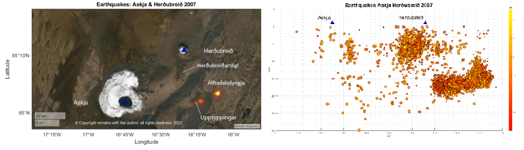
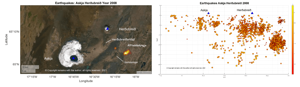
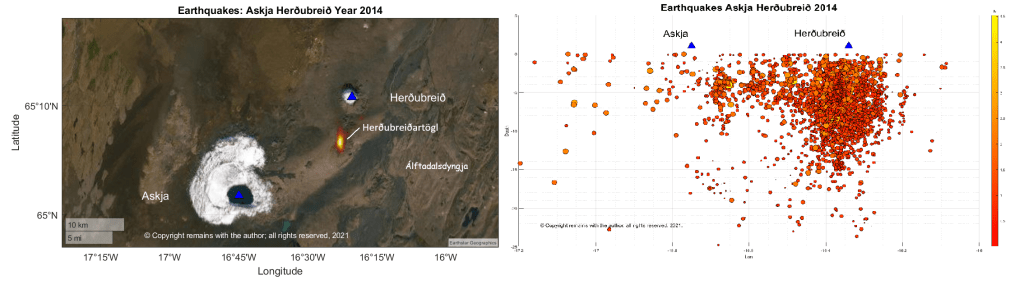
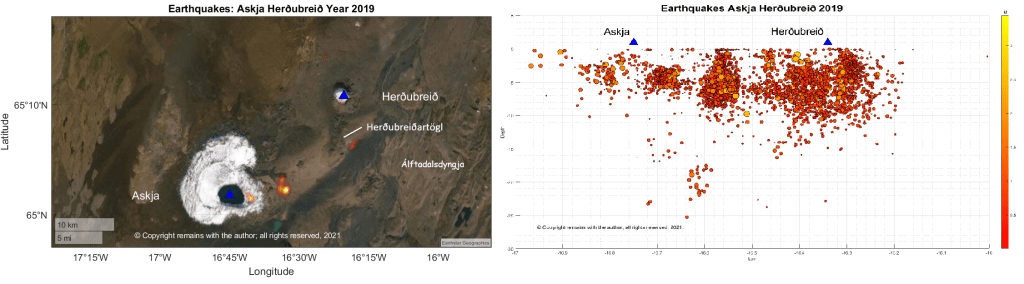
We plotted the area between 64.95°N,17.2°W and 65.3°N,16.0°W, a total of 45,899 earthquakes. As you can see from Fig 4, the area is very active (although perhaps we should not have used green dots in retrospect– Askja looks very unwell as a result).
The latitude v longitude scatter plot shows that activity follows a NE-SW pattern around Herðubreið, with a swarm to the south east; activity around Askja is focussed on the SE section of the caldera with some further east. The plots are data-heavy so we have broken these down by year.
In 2007 and 2008, there was a swarm that started in Upptyppingar and progressed to Álftadalsdyngja; this is thought to be due to magma movement. 2014 is the same year as the Barðarbunga eruption at Holuhraun; perhaps some of the seismicity is the result of the crust accommodating magma movement in the region, although the swarm here preceded the swarms at Barðarbunga. In 2019, there was a swarm to the east of the Askja caldera.
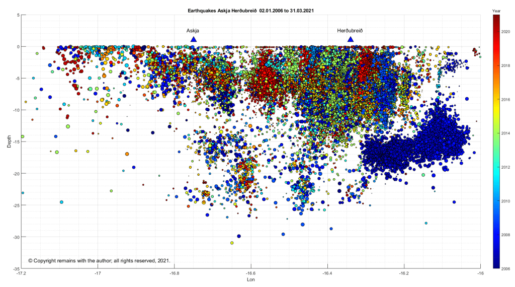
The earthquake density plots and depth v longitude plots for these years are set out in Figs 8 to 11 below.
Let’s see what the scientists have said. Greenfield et al (2016) have noted from seismic studies that there is considerable melt storage and transportation (movement) under the lower crust in the region (which may or may not be typical of Icelandic volcanoes – more study would be needed); there is likely to be a magma intrusive complex in the shallow crust round Askja; and, the activity round Herðubreið is caused by fracturing in the region.
The region is well monitored due to the risk of another rhyolitic eruption from Askja; this time around one may cause some disruption to aviation and communication systems, by how much would depend on the size and length of the eruption. In the light of the reawakening of Fagradalsfjall on the Reykjanes Peninsula, perhaps the Pleistocene volcanoes should be added to the watch list, although the monitoring of Holocene volcanoes is likely to pick up unusual activity.
La Soufrière St. Vincent
We have not forgotten La Soufrière St. Vincent; our thoughts are still with the islanders. We will do a fuller update soon. In the meantime, the volcano is still erupting and a new lava dome is forming in the crater. The island has lost up to 50% of its GDP. More aid is now reaching the island. For updates, we use News 784 (link below).
Barbados continues to clear up the volcanic ash; this is putting strain on local water supplies. For updates, we use Nation News Barbados.
R. Werner, H. U. Schmincke, G. Sigvaldason ,“A new model for the evolution of table mountains: volcanological and petrological evidence from Herðubreið and Herðubreiðartögl volcanoes (Iceland)”, Geologische Rundschau 85, Article number: 390 (1996). https://link.springer.com/article/10.1007/BF02422244
Thor Thordarson (Faculty of Earth Sciences, University of Iceland) and Al Margaret Hartley (University of Manchester (November 2019). Askja. In: Oladottir, B., Larsen, G. & Guðmundsson, M. T. Catalogue of Icelandic Volcanoes. IMO, UI and CPD-NCIP. Retrieved from http://icelandicvolcanoes.is/?volcano=ASK
“Classic Geology in Europe 3: Iceland”, Thor Thordarson & Armann Hoskuldsson, Terra Publishing, Third Edition, 2009.
This update is based on news reported from St Vincent and The Grenadines and Barbados up to 14 April 2021 (edited 16.04.2021).
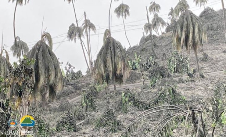
Fig 1: Ash covering vegetation in the red zone. Image by Prof. Richard Robertson, UWI-SRC.
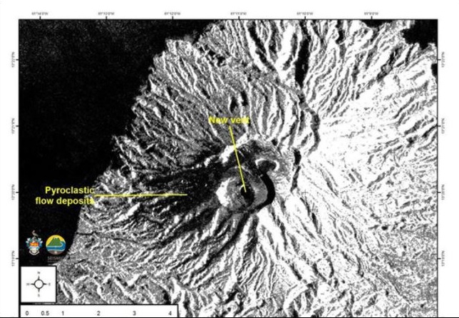
A new crater and vent were observed by satellites on 12 April 2021. Both lava domes have been destroyed.
Fig 2: Satellite image from the European Space Agency of the new crater and vent. The new vent and pyroclastic flows have been marked by UWI-SRC.
The North East of the island has been devastated; the agricultural area has been described by the Deputy Prime Minister of St Vincent & the Grenadines, Montgomery Daniel, as non-existent; trees and farms have been destroyed – only tree stumps are standing. He likens the damage to that caused by Hurricane Thomas. The crops lost include bananas, breadfruit, coconuts, mangos, soursop, plantains, arrowroot, dasheen and ginger and yams. The island’s economy is heavily dependent on the export of bananas and tourism.
Pyroclastic flows caused by ash columns collapse occurred on 13 April 2021, hitting the eastern side of the volcano. Areas at risk are Georgetown, Sandy Bay, Owia, Fancy and other settlements. Lahars have been reported by Sandy Bay.
Pyroclastic flows on 12 April were observed on the western and southern flanks of the volcano, reaching the sea at Morne Ronde, Larikai and Trois Lopues Bay.
Water supplies were contaminated by ashfall. The water supply has been restored to most of the island excluding the red zone (Owia, Sandy Bay, Fancy and Heritage), having cleaned ash out of the supply systems. Bottled water has been supplied from Barbados (although Barbados is suffering from ashfall as well). Several other nations have sent water. Water testing kits have been supplied by the World Health Organisation and Pan American Health Organisation.
Loss of power supplies were reported on 11 April 2021. No mention has been made of their status since. But it can be assumed that every effort would have been made to restore them.
Venezuela is providing humanitarian support. Guyana, Grenada and others have also sent supplies. Financial aid has been sent by other Caribbean islands, the UK (among others), the UN and the World Bank.
Barbados continues to get ashfall. The opening of schools has been delayed to allow for a cleaning up operation (ash got in via ventilators and windows). Ash has impacted water supplies in the north.
Explosions were occurring roughly 14 hours apart, with swarms of small long period earthquakes in between. It had been hoped that the explosive activity had waned for a while after a longer gap and that the continuing long period and hybrid earthquakes signified growth of a new lava dome, but another explosion occurred at 06:15 this morning (16.04.2021). SO2 levels indicate that fresh magma is arriving from a deeper source. The eruption is currently categorised as a VEI 4. It is expected to continue for some time, following the pattern of the 1902 eruption.
The United Nations have stated that this humanitarian crisis could go on for some time and that it may extend to other nearby islands.
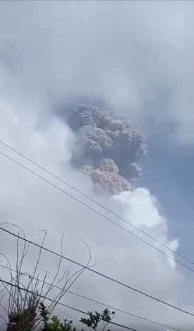
At the time of writing, there have been several explosive eruptions now from La Soufrière St. Vincent. The island has experienced extensive ashfall. The emergency evacuation has extended to the orange zone. Ash has reached 51,000 feet (38,000 feet, latest VAA) according to the volcanic ash alerts and the ash cloud has drifted over Barbados.
Fig 3: Ash plume from the first explosion. Photo from NEMO
Most of the new lava dome has been destroyed and the 1979 lava dome has suffered some damage. Removal of the rock has given magma a more open pathway. The eruption is expected to be larger than the 1979 eruption and to continue for some time; explosions are expected to be the same or greater magnitude. As far as we know, there have not been any pyroclastic flows but they are expected.
More than 3,000 people are in emergency accommodation and others are staying with friends or relatives. Saint Lucia, Grenada, Antigua and Barbados have offered to take refugees. Carnival Cruise Lines and the Royal Caribbean Group will send cruise ships to transport people to other islands. Venezuela has sent humanitarian aid and risk experts.
The north and west of Barbados have been hard hit by ash; the skies turned dark and ash is falling. Residents have been advised to stay indoors, except for essentials or a medical emergency. Beaches, parks and fish markets are closed for the time being. People with respiratory disorders have been advised to have their medication with them at all time. The airport and airspace is closed at the moment.
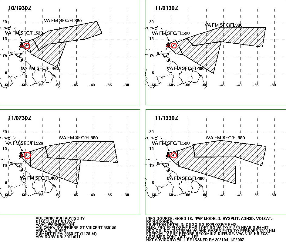
Latest VAA forecast:
Fig 4: Volcanic ash forecast from Washington VAAC Volcanic Ash Advisory (noaa.gov). The volcano is coloured in red and Barbados is in the red circle.
An explosive eruption started at La Soufrière St. Vincent around 12:40 pm GMT today, sending an ash column 8 km into the sky. The ash cloud reached 20,000 feet, drifting eastwards. Ashfall has been observed at Argyle International Airport.
Scientists warn that further larger eruptions are possible.
The evacuation from the red zone (northern end of the island) is still in progress at the time of writing.
Increasing gas emissions and seismic activity, including long period events, indicate that new magma is ascending at La Soufrière St. Vincent and an eruption could be imminent. An immediate evacuation order was given earlier today (c.1:00 am GMT) for the red zone in the north of the island, impacting 16,000 people.
Fig 1: La Soufrière St. Vincent, seen here from the south. Photo by Richard Fiske, 1980 (Smithsonian Institution).
The new lava dome has been steadily growing since it emerged in December 2020. The emission of gas and stream from the centre of the dome and its border with the 1979 dome increased on 8 April 2021. A preliminary VAA noted that a well-defined hotspot was visible in the SW. Incandescence from the dome was visible in St Lucia.
A swarm of volcano-tectonic earthquakes started on 6 April 2021 beneath the volcano at a depth of around 6 km. Long period earthquakes have also been observed, indicating that new magma is ascending.
Fig 2: New lava dome on 19 March 2021 between the 1979 lava dome on the right of the image and the crater wall on the left. Photo NEMO.
Background
Volcanic activity, here, is driven by the subduction of the South American Plate under the Caribbean Plate.
La Soufrière St. Vincent is a 1,234m high stratovolcano located in the north of St. Vincent Island, which rides on the Caribbean Plate. She is the youngest volcano on the island. At the summit there is a 1.6 km wide crater with a younger crater formed in the 1812 eruption, located in a 2.2 km wide Somma crater. Her lavas are typical of a subduction zone setting: andesite / basaltic andesite and basalt / picro-basalt.
GVP records 23 Holocene eruptions, the largest of which were VEI 4s in 1812 and 1902. The 1902 eruption devastated much of the northern end of the island. A lava dome was extruded in the eruption of 1971, which was destroyed to be replaced by a new dome in 1979 in a series of explosive eruptions. The 1902 eruption devastated much of the northern end of the island. Pyroclastic flows from eruptions in 1812, 1902, and 1979 reached the coast.
For advice and the status of La Soufrière St. Vincent, please consult NEMO or follow their Face Book page (links below).
Thoughts with those impacted by the evacuation and eruption.
Updated earthquake density video added (uses satellite image as background). 12.04.2021
Good Morning!
Geldingadalur – Where Are We at Now?
Since we last wrote, the new volcano at Geldingadalur has continued to erupt with a lava output rate between 5 m3 per second and 10 m3 per second, filling the Geldingadalur valley with more lava. The University of Iceland has confirmed that the early lava erupted has a magnesium content of 8.5%, a low titanium dioxide content and is more depleted in rare earth elements (low HREE to LREE ratio) than earlier historic lavas, indicating that it is a more primitive lava sourced from the lithospheric mantle at a depth of between 17 km and 20 km.
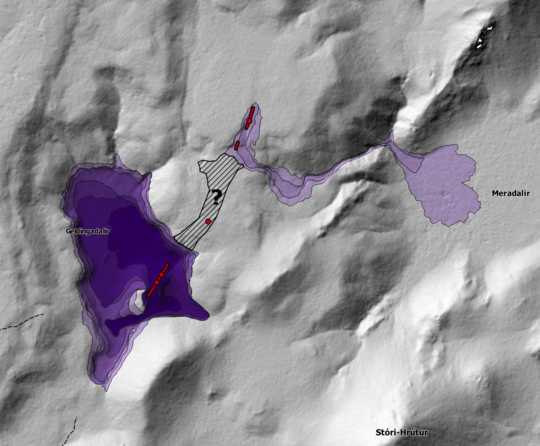
On 5 April 2021 at around midday, a new fissure opened up about 700 m north east of the original eruption site. The fissure, spotted by a sightseeing helicopter, was quickly confirmed by the RUV.is webcam monitoring Geldingadalur. Fortunately, no-one was in the vicinity at the time due to bad weather and sheer good luck; the site had been open to visitors at the time. The fissure is around 200 m long. Lava from the fissure is flowing into the Meradalir valley.
Fig 1: New fissure on 05.04.2021 in the foreground with lava flowing to Meradalir on the left of the image. The original Geldingadalur eruption is on the right of the image. Photo IMO.
Fig 2: Lava from the first new fissure entering Meradalir at 15:00 06.04.2021. The fissure itself is on the ridge in the background (Photograph: Public Protection/Björn Oddsson).
At around midnight on 6 April 2021, a second fissure opened up between the earlier fissure and the original eruption site. This had been preceded by a landslip earlier in the day. Lava from this fissure is now flowing into both the Geldingadalur and Meradalir valleys, linking the eruption sites. It is believed that the three eruption sites belong to the same fissure.
Fig 3: Photograph from Public Protection/Björn Oddsson showing the three eruption sites and lava flows.
Fig 4: Map showing the location of the three eruption sites from IMO. The fissures are shown as red lines and dots; and, lava flows are based on photography.
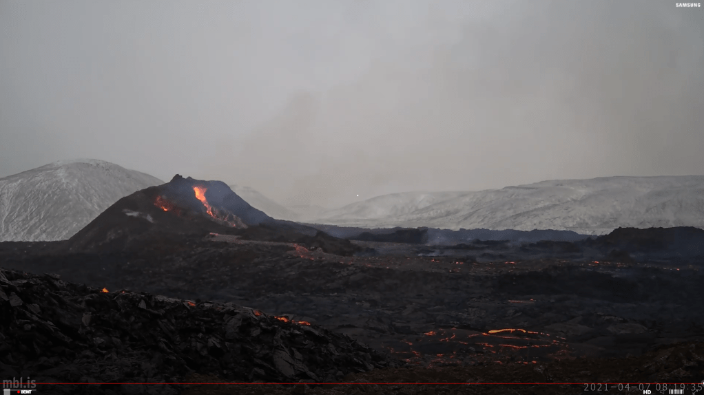
Unfortunately, one of the webcams set up by mbl.is to monitor the Geldingadalur cones was lost; its last image is shown below. We thank mbl.is for providing the webcam; we viewed its images with a lot of interest.
Fig 5: Screenshot from the mbl.is webcam.is set up to monitor the cones at Geldingadalur. This may be this webcam’s last image. The lava flow to the lower left of the image is from the newest fissure.
Like the original eruption site, neither fissure opening was heralded by an increase in seismicity in the immediate vicinity.
Seismicity Post the Initial Eruption
We have updated our earthquake plots for the period 19.03.2021 to 06.04.2021. We can confirm that there is very little earthquake activity in the vicinity of Geldingadalur. The fissures are not giving any seismic warning; seismic activity near Keilir dominates. It is perhaps surprising that magma has not made its way to the surface north east of Fagradalsfjall; does magma finds it easier to make its way through older fault-ridden Pleistocene rock that has not been covered in tougher historic lavas?
We have also tried our hand at making a video of the earthquake density plots by month from 2008 to 6 April 2021. Months are numbered from January 2008 (Month 1) to April 2021 (Month 160, which only has 6 days). If you make it all the way through, you will see that Fagradalsfjall has had several swarms, albeit much smaller than the current one. Enjoy!
The eruption at Geldingalur, Reykjanes, Iceland, which started on 19.03.2021 at 20:25, is continuing unabated as I write. The volcano is happily bubbling away building somewhat unstable but impressive looking cones and covering the Geldingadalur valley floor with lava.
Fig 1: Cones of Geldingadalur, cropped from an image by Berserkur, published under CC BY-SA 4.0
The eruption is steadily increasing at the time of writing; it has a lava output of 5 -7m3 per second. IMO have estimated that the valley would fill enough for lava to overflow into the neighbouring valley, Meradalir, in a matter of days at the current eruption rates.
Fig 2: Image by IMO. Expected path of the lava over the next few days at the current eruption rate.
Scientists at the University of Iceland are analysing the lava. To date, they have reported that the lava is a primitive one (i.e. little magma evolution in the crust), indicative of a mantle source at a depth of 17 km to 20 km.
Geological Setting
The Reykjanes Peninsula lies on oceanic crust created by the Mid Atlantic Ridge. The Peninsula, itself, straddles the Ridge. The crust here is 15 km thick, which is unusual so close to a spreading ridge. However, Iceland is a basaltic plateau overriding a mantle plume. Both the mantle plume and the Mid Atlantic Ridge influence formation of the crust. There are no magma chambers / reservoirs in the crust on the Peninsula; magma tends to ascend directly from the mantle.
The Peninsula is made up of lava shields, móberg hills, table mountains and fissure-fed lava flows and crater rows. The shield volcanoes on the Peninsula formed at the beginning of the Holocene between 10,000 and 7,000 years ago. Shield volcanoes form from hot picrite or olivine tholeiitic basaltic lava flows with rates of c . 5m3 per second. The móberg hills formed from submarine fissure eruptions and consist of pillow lavas, breccias and tuffs. The table mountains were formed from subglacial activity, which had the activity not been constrained by the ice cap, would have resulted in shields. Later Holocene activity has comprised effusive tholeiitic fissure eruptions which formed crater rows and produced large lava flows that now cover some of the earlier formations. Historic activity has been between 940 AD and 1340 AD, including the Reykjanes Fires of 1210 AD to 1240 AD; and, the Krýsuvík Fires of 1151 AD to 1188 AD.
Geldingadalur, itself, is a small valley to the south east of the summit of Fagradalsfjall, a 385m high hyaloclastite subglacial Pleistocene table mountain formed during the Weichselian glacial period, with a subaerial lava cap on its northwest part. It is currently classified as part of the Krýsuvík Volcanic System.
The Fagradalsfjall area is seismically very active, with large earthquake swarms, notably in 1998, 2000, and 2004, and again now as part of the new volcano-tectonic episode on the Reykjanes Peninsula that started in December 2019. Various studies from previous seismic activity have noted extensive faulting under the south west part of Fagradalsfjall; these faults strike N-S and NE -SW. In addition, there are two clusters of faults under the eastern part.
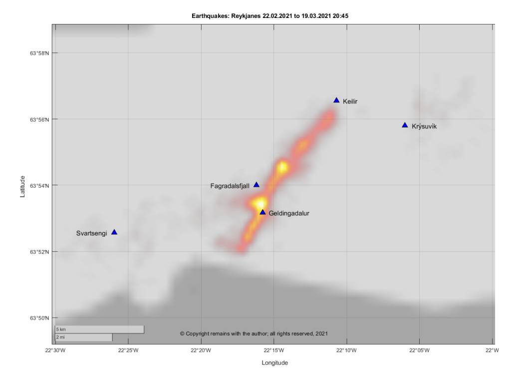
Earlier swarms in the current volcano-tectonic episode have resulted in magma intrusions, such as the one at Mt Þorbjörn which we discussed last year, but no eruption. The latest earthquake swarm which started on 22 February 2021 is the only one to result in an eruption at the time of writing.
Seismicity in the Current Swarm
We have updated our plots for the Reykjanes Peninsula and dividing them between the run up to the eruption on 19 March 2021 at 20:45 and after the eruption to 26 March 2021 15:55.
The plots preceding the eruption repeat the ones shown earlier so we are just showing the geodensity plot for comparison. You will note that the earthquakes do not reach down to 15 km in the current swarm to date. However, there were one or two deeper earthquake in some of the earlier episodes.
The plots for the period after the onset of the eruption (19.03.2021 20:45 to 26.03.2021 15.55) show that activity is concentrated on Geldingadalur and two spots north east of Fagradalsjall. Seismic activity has also extended further south.


